干旱气象 ›› 2026, Vol. 44 ›› Issue (3): 425-436.DOI: 10.11755/j.issn.1006-7639-2026-03-0425
滇西北高原一次典型对流性大暴雨天气过程分析
张崇莉( ), 董自香, 马妍, 靳宗许(), 杨锦涛, 秦香婷
云南省丽江市气象局 云南 丽江 674100
-
收稿日期:2025-10-31修回日期:2026-04-24出版日期:2026-06-30发布日期:2026-07-16 -
通讯作者:靳宗许(1989—),男,云南楚雄人,高级工程师,主要从事中短期天气预报预警服务工作。E-mail: jin_zongxu@163.com。
-
作者简介:张崇莉(1982—),女,云南丽江人,高级工程师,主要从事CINRAD/CC雷达相关工作。E-mail: 110562916@qq.com。 -
基金资助:2024年云南基层台站气象科技创新与能力提升计划项目(STIAP202440);2024年云南基层台站气象科技创新与能力提升计划项目(STIAP202445)
Analysis of a typical convective heavy rainfall process in the northwest plateau of Yunnan Province
ZHANG Chongli(), DONG Zixiang, MA Yan, JIN Zongxu(), YANG Jintao, QIN Xiangting
Lijiang Meteorological Bureau of Yunnan Province Lijiang 674100, Yunnan, China
-
Received:2025-10-31Revised:2026-04-24Online:2026-06-30Published:2026-07-16

摘要:
为探究滇西北高原对流性暴雨的触发机制,利用多源探测资料对2024年6月24日云南丽江市一次典型对流性暴雨过程进行诊断。结果表明:(1)此次过程主要受500 hPa副热带高压和滇缅高压之间的辐合区与700 hPa切变线共同影响,配合冷空气南下形成不稳定层结,为强降水提供了充足的动力条件和有利的环流背景。(2)大暴雨天气过程由局地生成的β中尺度、γ中尺度对流单体产生,对应雷达反射率因子最大达59.5 dBZ,速度图上存在速度模糊、涡旋、弱中气旋等特征。(3)暴雨水汽来源于孟加拉湾和南海,在地形辐合抬升作用下,丽江中部至东南部存在强水汽辐合区,强水汽辐合区与切变线位置对应良好;西南急流输送暖湿气流并增强低层辐合,高层西北急流通过抽吸作用加强上升运动,冷空气入侵进一步促进对流维持,强水汽聚集配合低层辐合、高层辐散的动力抬升条件,是局地大暴雨发生的主要原因。(4)丽江市南北走向山脉与地面辐合线共同作用,通过地形抬升和气流辐合触发并加强对流,成为此次大暴雨过程中对流持续触发和维持的重要因素,偏东气流对强对流发生具有较好的指示意义。(5)积状云降水回波中负闪峰值超前强降水约40 min,而积层混合云降水回波中则出现降水峰值提前现象。
中图分类号:
引用本文
张崇莉, 董自香, 马妍, 靳宗许, 杨锦涛, 秦香婷. 滇西北高原一次典型对流性大暴雨天气过程分析[J]. 干旱气象, 2026, 44(3): 425-436.
ZHANG Chongli, DONG Zixiang, MA Yan, JIN Zongxu, YANG Jintao, QIN Xiangting. Analysis of a typical convective heavy rainfall process in the northwest plateau of Yunnan Province[J]. Journal of Arid Meteorology, 2026, 44(3): 425-436.
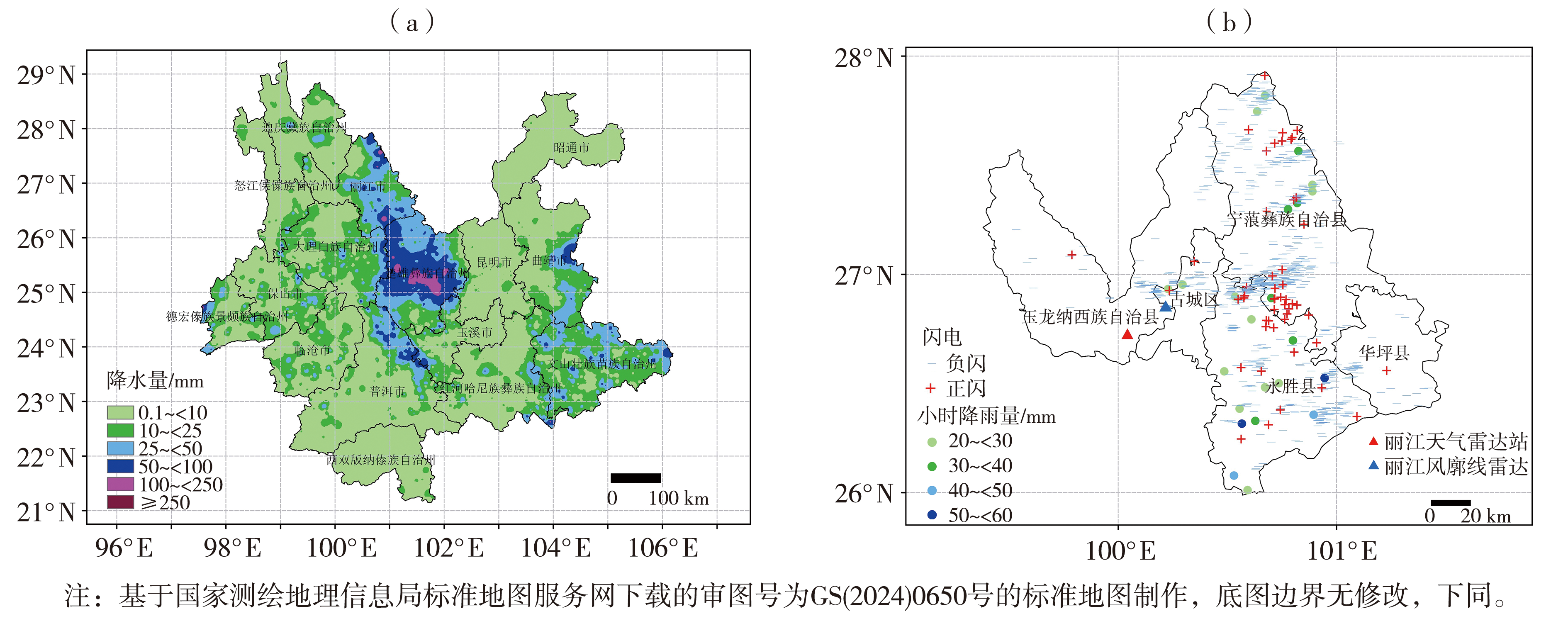
图1 2024年6月23日20:00—24日20:00云南区域自动站累计降水量(a)和丽江市短时强降水、闪电落区(b)分布
Fig.1 The distribution of accumulated precipitation from regional automatic weather stations in Yunnan (a) and short-term heavy rainfall and lightning zones in Lijiang (b) from 20:00 on June 23 to 20:00 on 24 June 2024
图1 2024年6月23日20:00—24日20:00云南区域自动站累计降水量(a)和丽江市短时强降水、闪电落区(b)分布
Fig.1 The distribution of accumulated precipitation from regional automatic weather stations in Yunnan (a) and short-term heavy rainfall and lightning zones in Lijiang (b) from 20:00 on June 23 to 20:00 on 24 June 2024

图2 2024年6月23日08:00(a)、20:00(b)500 hPa风场(风矢,单位:m·s-1)、高度场(蓝色实线,单位:dagpm)、温度场(红色虚线,单位:℃) (蓝色圆点代表丽江站,下同)
Fig.2 The 500 hPa wind fields (wind vectors, Unit: m·s-1), height fields (blue solid lines, Unit: dagpm) and temperature fields (red dashed lines, Unit: ℃) at 08:00 (a) and 20:00 (b) on 23 June 2024 (The blue dot represents Lijiang Station, the same as below)
图2 2024年6月23日08:00(a)、20:00(b)500 hPa风场(风矢,单位:m·s-1)、高度场(蓝色实线,单位:dagpm)、温度场(红色虚线,单位:℃) (蓝色圆点代表丽江站,下同)
Fig.2 The 500 hPa wind fields (wind vectors, Unit: m·s-1), height fields (blue solid lines, Unit: dagpm) and temperature fields (red dashed lines, Unit: ℃) at 08:00 (a) and 20:00 (b) on 23 June 2024 (The blue dot represents Lijiang Station, the same as below)
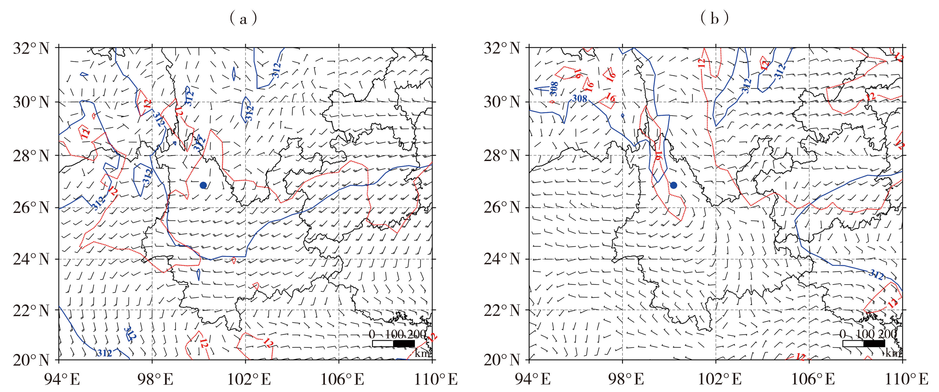
图3 2024年6月23日08:00(a)、20:00(b)700 hPa风场(风矢,单位:m·s-1)、高度场(蓝色实线,单位:dagpm)、温度场(红色虚线,单位:℃)
Fig.3 The 700 hPa wind fields (wind vectors, Unit: m·s-1), height fields (blue solid lines, Unit: dagpm) and temperature fields (red dashed lines, Unit: ℃) at 08:00 (a) and 20:00 (b) on 23 June 2024
图3 2024年6月23日08:00(a)、20:00(b)700 hPa风场(风矢,单位:m·s-1)、高度场(蓝色实线,单位:dagpm)、温度场(红色虚线,单位:℃)
Fig.3 The 700 hPa wind fields (wind vectors, Unit: m·s-1), height fields (blue solid lines, Unit: dagpm) and temperature fields (red dashed lines, Unit: ℃) at 08:00 (a) and 20:00 (b) on 23 June 2024

图4 2024年6月23日20:00(a)、22:00(b)与24日00:00(c)、02:00(d)700 hPa水汽通量(矢量,单位:g·cm-1·hPa-1·s-1)和水汽通量散度(填色,单位:10-4 g·cm-2·hPa-1·s-1)
Fig.4 The water vapor flux (vectors, Unit: g·cm-1·hPa-1·s-1) and water vapor flux divergence (the color shaded, Unit: 10-4 g·cm-2·hPa-1·s-1) at 700 hPa at 20:00 (a) and 22:00 (b) on 23 June, 00:00 (c) and 02:00 (d) on 24 June 2024
图4 2024年6月23日20:00(a)、22:00(b)与24日00:00(c)、02:00(d)700 hPa水汽通量(矢量,单位:g·cm-1·hPa-1·s-1)和水汽通量散度(填色,单位:10-4 g·cm-2·hPa-1·s-1)
Fig.4 The water vapor flux (vectors, Unit: g·cm-1·hPa-1·s-1) and water vapor flux divergence (the color shaded, Unit: 10-4 g·cm-2·hPa-1·s-1) at 700 hPa at 20:00 (a) and 22:00 (b) on 23 June, 00:00 (c) and 02:00 (d) on 24 June 2024
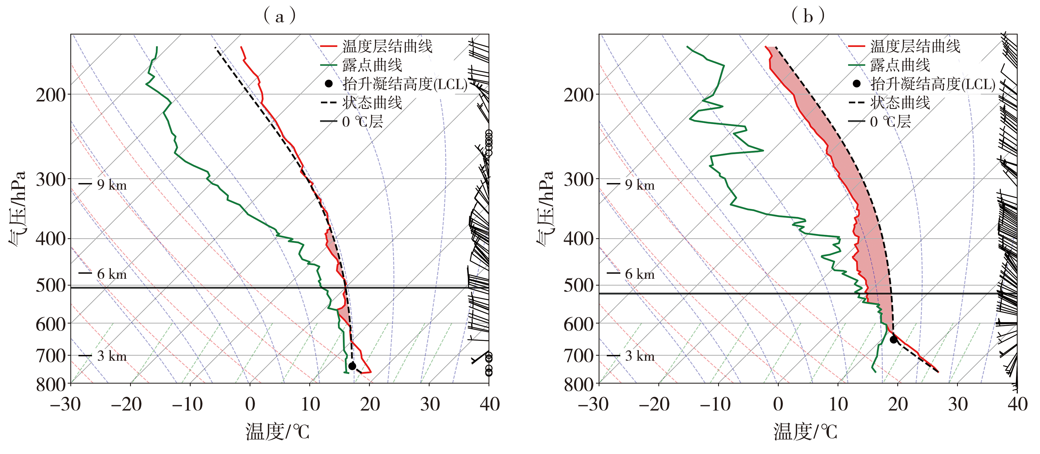
图5 2024年6月23日08:00(a)、20:00(b)丽江站T-ln P图 (黑色圆圈表示风速<2 m·s-1)
Fig.5 The T-ln P charts at 08:00 (a) and 20:00 (b) at Lijiang Station on 23 June 2024 (Black circles represent wind speed less than 2 m·s-1)
图5 2024年6月23日08:00(a)、20:00(b)丽江站T-ln P图 (黑色圆圈表示风速<2 m·s-1)
Fig.5 The T-ln P charts at 08:00 (a) and 20:00 (b) at Lijiang Station on 23 June 2024 (Black circles represent wind speed less than 2 m·s-1)

图6 2024年6月23日20:00(a)、22:00(b)与24日00:00(c)、02:00(d)700 hPa风场(矢量,单位:m·s-1)和垂直速度(填色,单位:Pa·s-1)
Fig.6 The wind fields (vectors, Unit: m·s-1) and vertical velocity (the color shaded, Unit: Pa·s-1) at 700 hPa at 20:00 (a), 22:00 (b) on 23 June, and 00:00 (c), 02:00 (d) on 24 June 2024
图6 2024年6月23日20:00(a)、22:00(b)与24日00:00(c)、02:00(d)700 hPa风场(矢量,单位:m·s-1)和垂直速度(填色,单位:Pa·s-1)
Fig.6 The wind fields (vectors, Unit: m·s-1) and vertical velocity (the color shaded, Unit: Pa·s-1) at 700 hPa at 20:00 (a), 22:00 (b) on 23 June, and 00:00 (c), 02:00 (d) on 24 June 2024

图7 2024年6月23日20:33(a、b)、22:06(c、d)、22:53(e、f)及24日00:26(g、h)丽江市多普勒雷达组合反射率(a、c、e、g,单位:dBZ)和1.5°仰角基本径向速度(b、d、f、h,单位:m·s-1)
Fig.7 The radar composite reflectivity factor (a, c, e, g, Unit: dBZ) and 1.5° elevation radial velocity (b, d, f, h, Unit: m·s-1) from Lijiang doppler weather radar at 20:33 (a, b), 22:06 (c, d), 22:53 (e, f) on 23 June and 00:26 (g, h) on 24 June 2024
图7 2024年6月23日20:33(a、b)、22:06(c、d)、22:53(e、f)及24日00:26(g、h)丽江市多普勒雷达组合反射率(a、c、e、g,单位:dBZ)和1.5°仰角基本径向速度(b、d、f、h,单位:m·s-1)
Fig.7 The radar composite reflectivity factor (a, c, e, g, Unit: dBZ) and 1.5° elevation radial velocity (b, d, f, h, Unit: m·s-1) from Lijiang doppler weather radar at 20:33 (a, b), 22:06 (c, d), 22:53 (e, f) on 23 June and 00:26 (g, h) on 24 June 2024

图8 2024年6月23日20:33(a、e)、22:06(b、f)、22:53(c、g)与24日00:26(d、h)丽江天气雷达反射率(a、b、c、d,单位:dBZ)与径向速度(e、f、g、h,单位:m·s-1)剖面
Fig.8 The profiles of reflectivity factor (a, b, c, d, Unit: dBZ) and radial velocity (e, f, g, h, Unit: m·s-1) from Lijiang weather radar at 20:33 (a, e), 22:06 (b, f), 22:53 (c, g) on 23 June and 00:26 (d, h) on 24 June 2024
图8 2024年6月23日20:33(a、e)、22:06(b、f)、22:53(c、g)与24日00:26(d、h)丽江天气雷达反射率(a、b、c、d,单位:dBZ)与径向速度(e、f、g、h,单位:m·s-1)剖面
Fig.8 The profiles of reflectivity factor (a, b, c, d, Unit: dBZ) and radial velocity (e, f, g, h, Unit: m·s-1) from Lijiang weather radar at 20:33 (a, e), 22:06 (b, f), 22:53 (c, g) on 23 June and 00:26 (d, h) on 24 June 2024

图9 2024年6月23日21:00—24日03:00丽江站风羽图(单位:m·s-1)
Fig.9 The wind barbs chart over Lijiang Station from 21:00 on June 23 to 03:00 on 24 June 2024 (Unit: m·s-1)
图9 2024年6月23日21:00—24日03:00丽江站风羽图(单位:m·s-1)
Fig.9 The wind barbs chart over Lijiang Station from 21:00 on June 23 to 03:00 on 24 June 2024 (Unit: m·s-1)
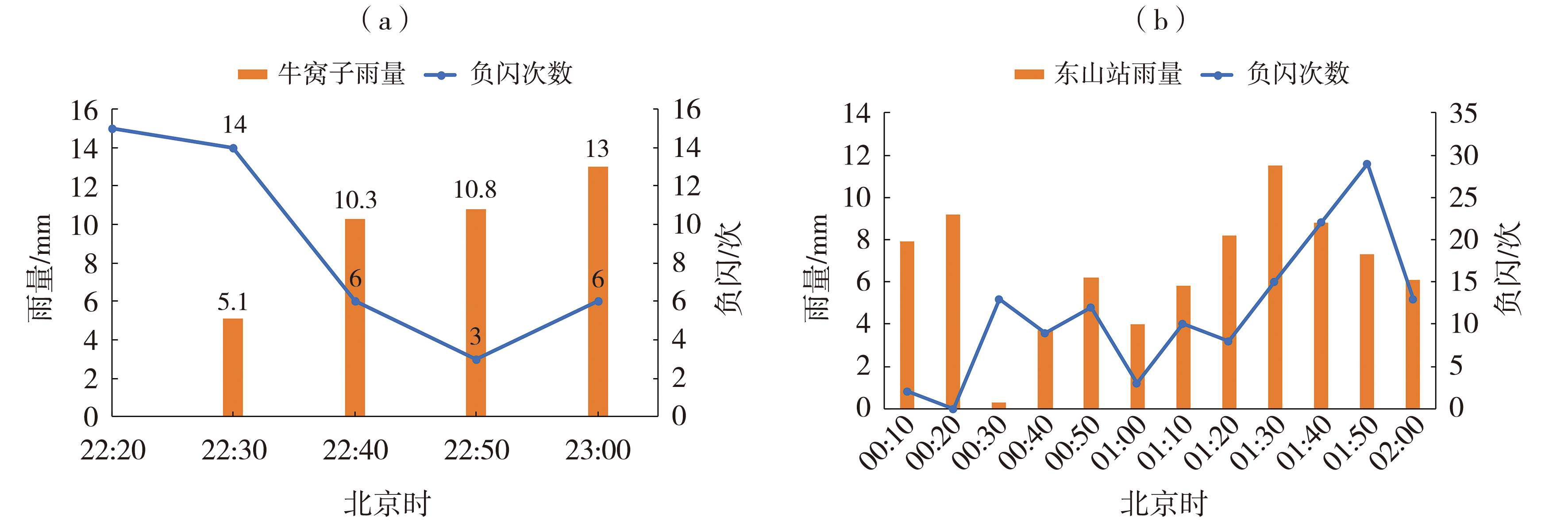
图10 2024年6月23日22:20—23:00牛窝子站(a)和24日00:00—02:00东山站(b)10 min雨量、负闪次数变化
Fig.10 The variation of 10-minute precipitation and number of negative lightning at Niuwozi Station from 22:20 to 23:00 on 23 June (a) and at Dongshan Station from 00:00 to 02:00 on 24 June (b) 2024
图10 2024年6月23日22:20—23:00牛窝子站(a)和24日00:00—02:00东山站(b)10 min雨量、负闪次数变化
Fig.10 The variation of 10-minute precipitation and number of negative lightning at Niuwozi Station from 22:20 to 23:00 on 23 June (a) and at Dongshan Station from 00:00 to 02:00 on 24 June (b) 2024
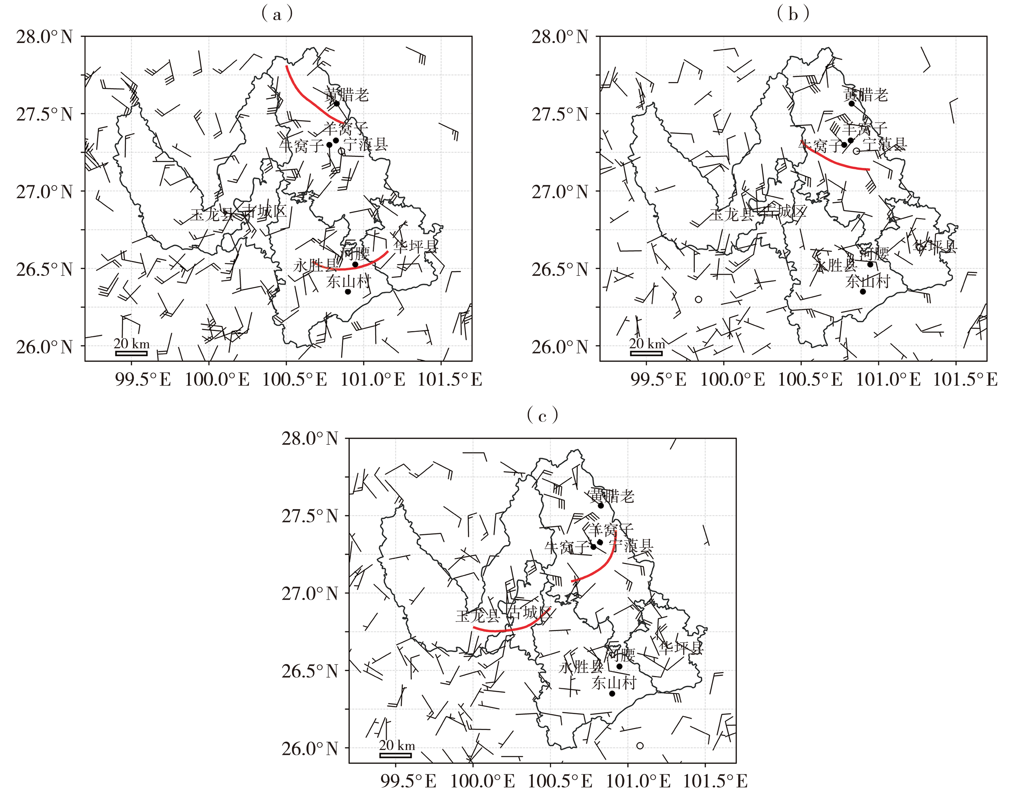
图11 2024年6月23日17:00(a)、23:00(b)和24日00:00(c)地面风场(单位:m·s-1)和辐合线(红色实线)
Fig.11 The ground wind fields (Unit: m·s-1) and convergence lines (solid red lines) at 17:00 (a), 23:00 (b) on 23 June and 00:00 on 24 June (c) 2024
图11 2024年6月23日17:00(a)、23:00(b)和24日00:00(c)地面风场(单位:m·s-1)和辐合线(红色实线)
Fig.11 The ground wind fields (Unit: m·s-1) and convergence lines (solid red lines) at 17:00 (a), 23:00 (b) on 23 June and 00:00 on 24 June (c) 2024
| [1] | 贺哲, 王君, 栗晗, 等, 2020. 河南省一次副高边缘对流性暴雨的多尺度特征[J]. 干旱气象, 38(3): 423-432. |
| [2] | 李华宏, 许彦艳, 王曼, 等, 2020. 低纬高原一次短时强降水过程的综合分析[J]. 云南大学学报:自然科学版, 42(3): 515-524. |
| [3] | 李梦, 竹利, 张悦含, 2025. 四川盆地一次极端暴雨过程的演变及成因分析[J]. 干旱气象, 43(2): 242-253. |
| [4] | 李永军, 徐金波, 李玄, 等, 2025. 四川南部一次局地暖区暴雨中尺度特征及成因[J]. 大气科学, 49(3): 664-680. |
| [5] | 梁军, 贾旭轩, 张胜军, 等, 2025. 辽东半岛一次大暴雨过程触发和维持机制分析[J]. 干旱气象, 43(3): 435-449. |
| [6] | 刘红武, 胡燕, 苏涛, 等, 2021. 2019年主汛期湖南两次致灾暴雨过程对比分析[J]. 高原气象, 40(5): 1 101-1 114. |
| [7] | 柳龙生, 刘璐, 李英, 2025. 2023年7月一次华北极端暴雨的多尺度特征[J]. 大气科学, 49(3): 645-663. |
| [8] | 鲁亚斌, 李华宏, 闵颖, 等, 2018. 一次云南强对流暴雨的中尺度特征分析[J]. 气象, 44(5): 645-654. |
| [9] | 马志敏, 王将, 连钰, 等, 2023. 云南一次强对流暴雨天气学成因分析[J]. 干旱气象, 41(4): 629-638. |
| [10] | 全国气象防灾减灾标准化技术委员会, 2012. 降水量等级:GB/T 28592—2012[S]. 北京: 中国标准出版社. |
| [11] | 石延召, 刘维成, 傅朝, 等, 2024. 甘肃陇南两次暴雨天气过程对比分析[J]. 干旱气象, 42(1): 107-116. |
| [12] | 王青霞, 唐明晖, 吴亚昊, 等, 2025. 基于多源观测资料的长沙“4·29”强对流天气过程分析[J]. 暴雨灾害, 44(3): 309-321. |
| [13] | 魏庆, 周威, 吴容, 等, 2023. 盆地西部一次极端短时强降水过程的多源资料分析[J]. 高原山地气象研究, 43(2): 19-27. |
| [14] | 解明恩, 段纬, 2022. 风雨彩云南:云南气象略论[M]. 昆明: 云南科技出版社: 10-14. |
| [15] | 闫玮, 欧阳智, 王泳棋, 等, 2024. 2021年“7·20”河南特大暴雨水汽输送特征[J]. 兰州大学学报:自然科学版, 60(2): 143-150. |
| [16] | 杨霞, 何清, 李圆圆, 等, 2023. 塔里木东风低空急流在南疆暴雨和非暴雨过程中的差异[J]. 大气科学, 47(6): 1 693-1 708. |
| [17] | 杨秀梅, 孔祥伟, 王勇, 等, 2023. 一次干旱区极端暴雨天气的中尺度特征分析[J]. 高原气象, 42(4): 978-992. |
| [18] | 袁凯, 庞晶, 李武阶, 等, 2023. 深度学习模型在2021年汛期武汉市雷达回波临近预报中的应用评估[J]. 干旱气象, 41(1): 173-185. |
| [19] | 袁薇, 高学浩, 2018. 天气雷达探测与应用[M]. 北京: 气象出版社. |
| [20] | 张腾飞, 段旭, 张杰, 等, 2011. 云南强对流暴雨的闪电和雷达回波特征及相关性[J]. 热带气象学报, 27(3): 379-386. |
| [21] | 张腾飞, 张杰, 尹丽云, 2023. 滇西南一次超级单体持续降雹过程分析[J]. 云南大学学报:自然科学版, 45(2):409-417. |
| [22] | 周鹏康, 秦金梅, 2016. 云南1981—2010年雨季暴雨时空分布特征[J]. 云南地理环境研究, 28(4): 63-69. |
| [23] | 周伟东, 韩宁, 戴建华, 等, 2022. 上海地区暴雨预警评估及不同天气型暴雨预警差异分析[J]. 暴雨灾害, 41(4): 405-412. |
| [24] | FOWLER H J, LENDERINK G, PREIN A F, et al, 2021. Anthropogenic intensification of short-duration rainfall extremes[J]. Nature Reviews Earth & Environment, 2(2): 107-122. |
| [25] | HAN J Y, DU H B, WU Z F, et al, 2019. Changes in extreme precipitation over dry and wet regions of China during 1961-2014[J]. Journal of Geophysical Research: Atmospheres, 124(11): 5 847-5 859. |
| [26] | KEBEDE A, WARRACH-SAGI K, SCHWITALLA T, et al, 2024. Assessment of seasonal rainfall prediction in Ethiopia: Evaluating a dynamic recurrent neural network to downscale ECMWF-SEAS5 Rainfall[J]. Advances in Atmospheric Sciences, 41(11): 2 230-2 244. |
| [27] | LIU S K, CHANG G X, 2025. Spatial-temporal analysis of precipitation extremes over China during 1961-2019[J]. Discover Atmosphere, 3(24): 1-17. |
| [28] | WANG Q, ZHAI P M, ZHANG Q, 2025. Regional patterns of climate change and extreme events in China since 1961[J]. Journal of meteorological research, 39 (3): 688-697. |
| [29] | YANG J, HE S, BAO Q, 2021. Convective/large-scale rainfall partitions of tropical heavy precipitation in CMIP6 atmospheric models[J]. Advances in Atmospheric Sciences, 38(6): 1 020-1 027. |
| [1] | 高雷娜, 翟亮, 张琳, 王忠石, 韩亚静, 焦洋. 基于新型观测资料的徒骇-马颊河流域“8·26”极端降水过程分析[J]. 干旱气象, 2026, 44(3): 412-424. |
| [2] | 汤浩, 周雅蔓, 安大维, 王敏仲. 天山峡谷北缘一次极端下坡风暴三维结构及触发机理分析[J]. 干旱气象, 2026, 44(2): 241-253. |
| [3] | 马玉芳, 于波, 马秀梅, 郑玲, 马守存, 梁依玲, 王佳琳. 近10 a北京地区10月两次区域性寒潮天气过程对比分析[J]. 干旱气象, 2026, 44(1): 138-148. |
| [4] | 董琪如, 王莹, 李英华, 杨旭, 梁康壮. 京津冀地区一次极端暖区暴雨成因分析[J]. 干旱气象, 2026, 44(1): 115-125. |
| [5] | 任丽, 卜文惠, 于震宇, 白俊杰, 李瑶. 一次伴有极端降水的东北冷涡过程分析[J]. 干旱气象, 2025, 43(6): 939-952. |
| [6] | 崔慧慧, 李荣, 孙存永. 郑州短时强降水精细时空分布特征及地形影响[J]. 干旱气象, 2025, 43(6): 920-930. |
| [7] | 艾润冰, 王璐璐. 远距离热带气旋影响下的驻马店暴雨特征和预报思路[J]. 干旱气象, 2025, 43(6): 891-900. |
| [8] | 姬雪帅, 康博思, 侯晓琦, 郭旭晖, 石文伯, 黄山江. 京津冀地区“23·7”特大暴雨精细化特征及成因分析[J]. 干旱气象, 2025, 43(6): 878-890. |
| [9] | 黄丽娜, 陈艳真, 陈宇航, 李忆平, 杨明灿, 陈诗琳. “杜苏芮”台风过程中莆田市特大暴雨阶段性和强度特征[J]. 干旱气象, 2025, 43(5): 713-722. |
| [10] | 江远安, 杨柳, 于碧馨, 周雅蔓, 余行杰, 张俊兰. 库车河铜场水库典型雨洪过程的气象水文特征[J]. 干旱气象, 2025, 43(5): 733-744. |
| [11] | 赵睿峰, 张桂莲, 黄晓璐, 霍志丽, 江靖. 内蒙古东南部一次伴冻雨的极端暴雪天气特征[J]. 干旱气象, 2025, 43(4): 607-615. |
| [12] | 王文波, 李晓利, 曹云飞, 杨明, 高晓梅, 杨萌. 风廓线雷达资料在一次对流暴雨过程中的特征分析[J]. 干旱气象, 2025, 43(4): 627-636. |
| [13] | 徐庆喆, 徐爽, 金巍, 田璐, 高清源, 谭政华, 孙安妮. 辽宁两次极端雨转暴雪过程对比分析[J]. 干旱气象, 2025, 43(3): 450-459. |
| [14] | 杨芳园, 杨素雨, 甄廷忠, 杨竹云, 李晓鹏, 胡勇华, 石宝灵. 云南省一次罕见飑线过程发生机制分析[J]. 干旱气象, 2025, 43(2): 265-276. |
| [15] | 胡嘉缨, 赵桂香, 闫慧, 徐逸雯, 操俊伟. 复杂地形下一次飑线的组织化过程及成因分析[J]. 干旱气象, 2025, 43(2): 289-299. |
| 阅读次数 | ||||||
|
全文 |
|
|||||
|
摘要 |
|
|||||
