干旱气象 ›› 2025, Vol. 43 ›› Issue (6): 878-890.DOI: 10.11755/j.issn.1006-7639-2025-06-0878
京津冀地区“23·7”特大暴雨精细化特征及成因分析
姬雪帅1,2( ), 康博思2, 侯晓琦2, 郭旭晖2, 石文伯2, 黄山江2()
1.成都信息工程大学大气科学学院 四川 成都 610225 2.河北省张家口市气象局 河北 张家口 075000
-
收稿日期:2025-03-22修回日期:2025-07-09出版日期:2025-12-31发布日期:2026-01-19 -
通讯作者:黄山江(1969—),男,正高级工程师,主要从事中短期天气预报。E-mail: 407649759@qq.com。
-
作者简介:姬雪帅(1991—),男,高级工程师,主要从事短时临近天气预报及其相关方法研究。E-mail: 1358744797@qq.com。 -
基金资助:河北省气象局科研项目(25ky07);张家口市劳模和工匠人才创新工作室共同资助
Refined characteristics and cause analysis of the “23·7” extraordinary heavy rainfall in Beijing-Tianjin-Hebei region
JI Xueshuai1,2(), KANG Bosi2, HOU Xiaoqi2, GUO Xuhui2, SHI Wenbo2, HUANG Shanjiang2()
1. School of Atmospheric Sciences ,Chengdu University of Information & Technology Chengdu 610225, China 2. Zhangjiakou Meteorological Bureau of Hebei Province ,Zhangjiakou 075000 Hebei, China
-
Received:2025-03-22Revised:2025-07-09Online:2025-12-31Published:2026-01-19
摘要:
为探究登陆台风强降水的形成机制,探索高分辨率资料在持续性强降水中的应用,剖析动力、热力等要素的协同作用,利用地面气象站降水资料、欧洲中期天气预报中心再分析资料、雨滴谱资料和双偏振雷达资料对发生在2023年7月29日—8月1日的“23·7”京津冀地区特大暴雨天气过程的观测特征及热动力成因进行分析。结果表明:1)副热带高压与大陆高压脊形成的高压坝阻滞台风“杜苏芮”残余环流,东高西低的环流配置为暴雨提供了稳定的环流背景;2)降水以小雨滴为主,标准化数浓度随雨强增大而升高,表明降水量级主要由高数浓度粒子驱动,呈现典型的热带降水特征;3)锋生作用通过切变变形项和水平散度项触发锋面次级环流,形成强烈的垂直运动,延长降水持续时间;4)凝结潜热释放通过正反馈机制增强上升运动与水汽辐合,与锋生作用协同驱动暴雨维持。三者关系表明:高数浓度小雨滴的微物理特征受暖云碰并-破碎平衡调控,锋生作用提供动力抬升条件,而凝结潜热释放则通过加热大气进一步强化动力环流,形成“微物理-动力-热力”耦合的暴雨增强机制。
中图分类号:
引用本文
姬雪帅, 康博思, 侯晓琦, 郭旭晖, 石文伯, 黄山江. 京津冀地区“23·7”特大暴雨精细化特征及成因分析[J]. 干旱气象, 2025, 43(6): 878-890.
JI Xueshuai, KANG Bosi, HOU Xiaoqi, GUO Xuhui, SHI Wenbo, HUANG Shanjiang. Refined characteristics and cause analysis of the “23·7” extraordinary heavy rainfall in Beijing-Tianjin-Hebei region[J]. Journal of Arid Meteorology, 2025, 43(6): 878-890.

图1 京津冀区域2023年7月29日08:00—8月1日08:00累计降水量(a)及29日08:00—30日08:00(b)、30日08:00—31日08:00(c)、31日08:00—8月1日08:00(d)逐24 h降水量空间分布(单位:mm)
Fig.1 The spatial distribution of cumulative precipitation from 08:00 July 29 to 08:00 August 1 (a), and 24-hour precipitation from 08:00 on 29 July to 08:00 on 30 July (b), from 08:00 on 30 July to 08:00 on 31 July (c), and from 08:00 on 31 July to 08:00 on 1 August 2023 (d) in the Beijing-Tianjin-Hebei region (Unit: mm)

图2 2023年7月29日08:00—8月1日08:00梁家庄站(a)和紫荆关站(b)逐小时雨量分布
Fig.2 The hourly rainfall distribution at Liangjiazhuang Station (a) and Zijingguan Station (b) from 08:00 on 29 July to 08:00 on 1 August 2023
图2 2023年7月29日08:00—8月1日08:00梁家庄站(a)和紫荆关站(b)逐小时雨量分布
Fig.2 The hourly rainfall distribution at Liangjiazhuang Station (a) and Zijingguan Station (b) from 08:00 on 29 July to 08:00 on 1 August 2023

图3 2023年7月30日20:00(a)和31日20:00(b)500 hPa高度场(黑色等值线,单位:dagpm)、850 hPa相对湿度(填色,单位:%)及风场(风矢,单位:m·s-1) (图中黑色方框为研究区域)
Fig.3 Height field (black contours, Unit: dagpm) at 500 hPa, relative humidity (the grey shaded, Unit: %) and wind field (wind vectors, Unit: m·s-1) at 850 hPa at 20:00 on 30 (a) and 20:00 on 31 (b) July 2023 (The black box represents the study area)

图4 2023年7月29日—8月1日怀来站(a、c)和保定站(b、d)雨滴数浓度(a、b,单位:mm-1·m-3)和雨强(c、d)随时间的变化
Fig.4 The variation of raindrop number concentration (a, b, Unit: mm-1·m-3) and rainfall intensity (c, d) at Huailai Station (a, c) and Baoding Station (b, d) from 29 July to 1 August 2023
图4 2023年7月29日—8月1日怀来站(a、c)和保定站(b、d)雨滴数浓度(a、b,单位:mm-1·m-3)和雨强(c、d)随时间的变化
Fig.4 The variation of raindrop number concentration (a, b, Unit: mm-1·m-3) and rainfall intensity (c, d) at Huailai Station (a, c) and Baoding Station (b, d) from 29 July to 1 August 2023

图5 怀来站(a、c)和保定站(b、d)雨滴质量加权直径(a、b)和标准化数浓度(c、d)与雨强的散点图
Fig.5 The scatter plots of mass-weighted average diameter (a, b) and standardized number concentration (c, d) of raindrops with rain intensity at Huailai Station (a, c) and Baoding Station (b, d)
图5 怀来站(a、c)和保定站(b、d)雨滴质量加权直径(a、b)和标准化数浓度(c、d)与雨强的散点图
Fig.5 The scatter plots of mass-weighted average diameter (a, b) and standardized number concentration (c, d) of raindrops with rain intensity at Huailai Station (a, c) and Baoding Station (b, d)
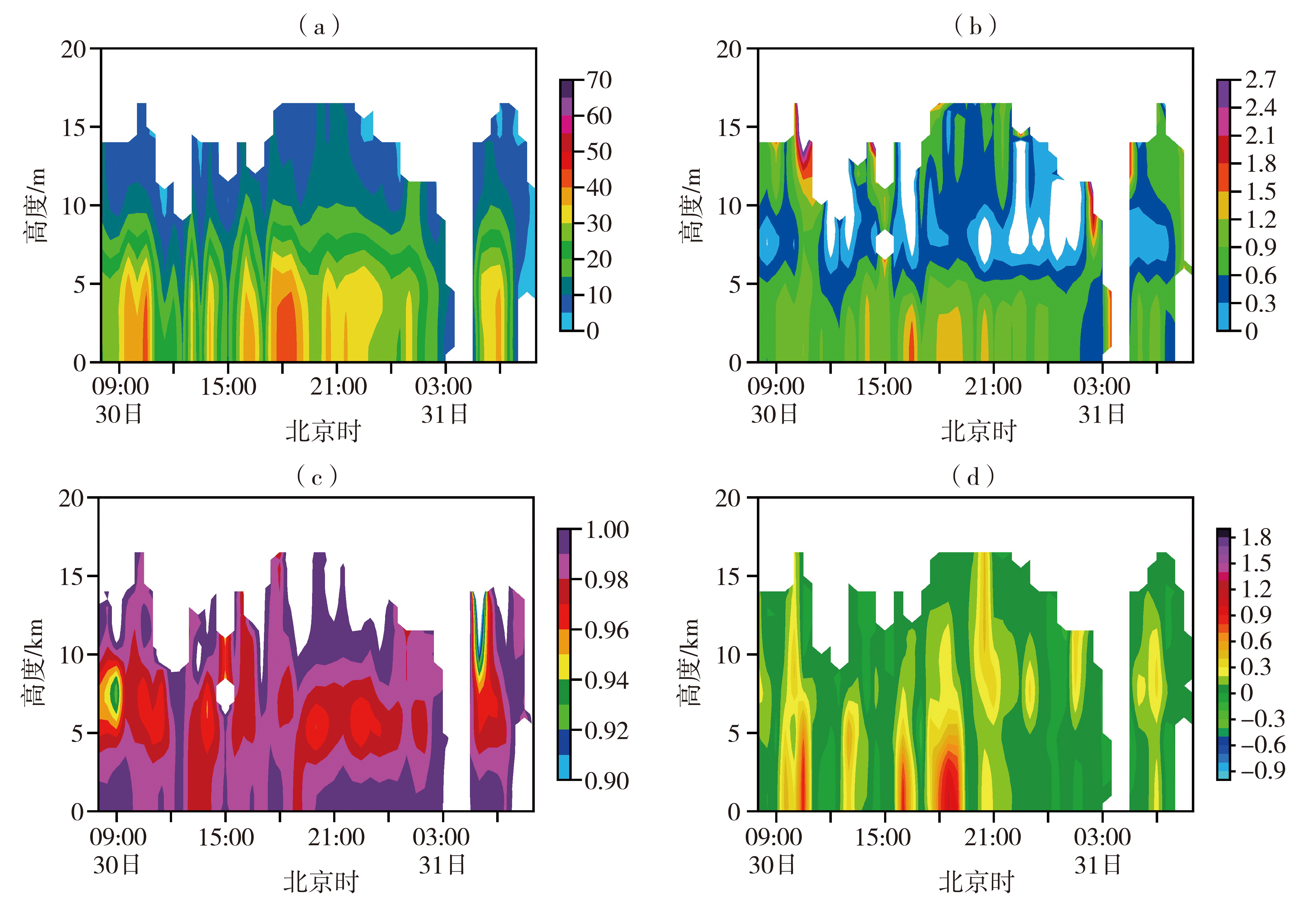
图6 2023年7月30—31日保定站双偏振雷达反射率因子(a,单位:dBZ)、差分反射率因子(b,单位:dB)、相关系数(c)及差分相移率[d,单位:(°)·km-1]的时间-高度剖面
Fig.6 The time-altitude profiles of the reflectivity factor (a, Unit: dBZ), differential reflectivity factor (b, Unit: dB), correlation coefficient (c), and differential phase shift rate (d, Unit: (°)·km-1) of the dual-polarization radar at Baoding Station during 30-31 July 2023
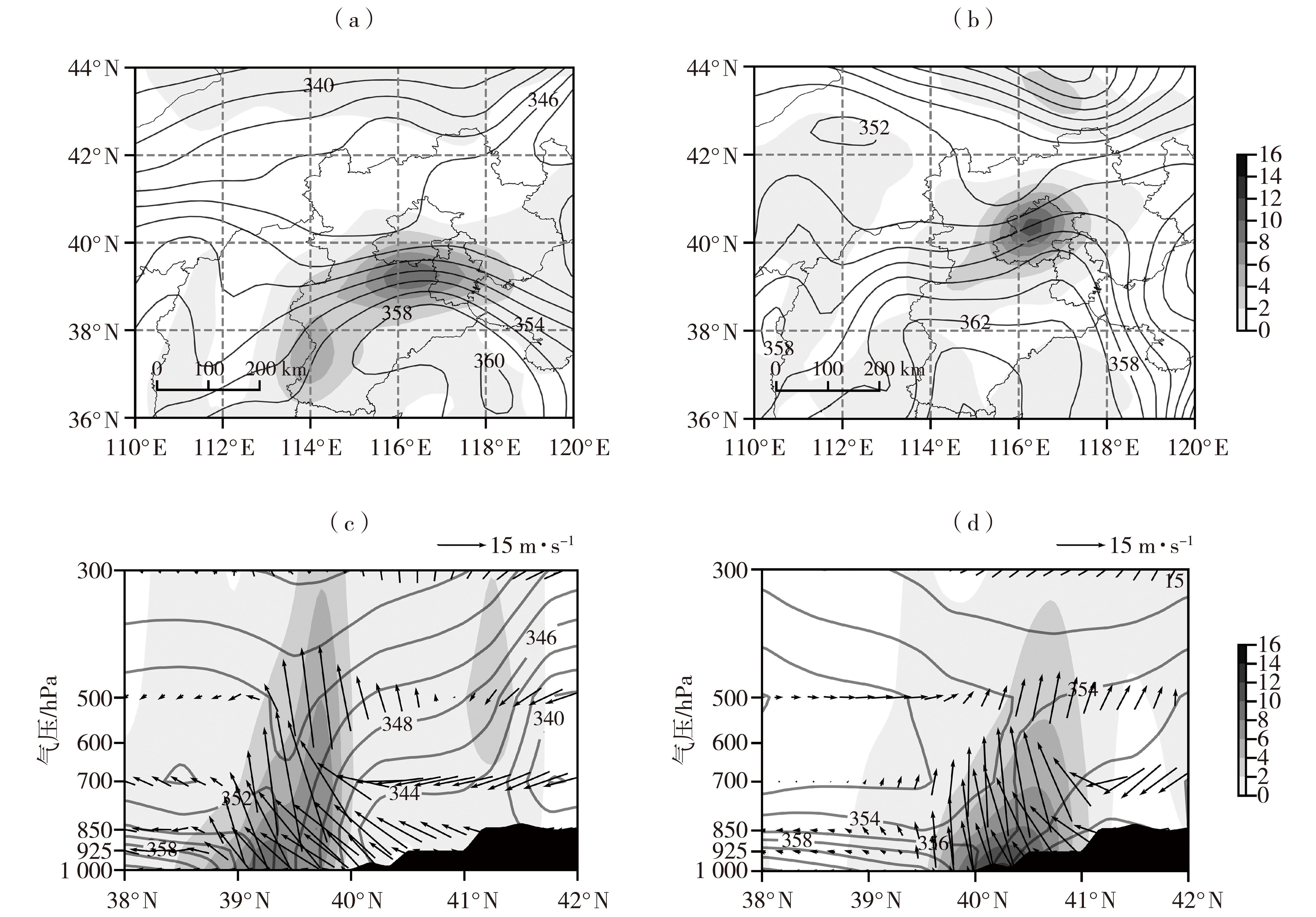
图7 2023年7月30日14:00(a、c)和31日14:00(b、d)925 hPa锋生函数(灰色阴影,单位:10-9 K·m-1·s-1)和假相当位温(等值线,单位:K)(a、b)及沿115.5°E的经向风和垂直速度合成矢量(矢量箭头,单位:m·s-1)、假相当位温(等值线,单位:K)和锋生函数(灰色阴影,单位:10-9 K·m-1·s-1)的纬度-高度剖面(c、d) (黑色阴影是地形)
Fig.7 The 925 hPa frontogenetic function (the grey shaded, Unit: 10?? K·m?¹·s?¹) and pseudo-equivalent potential temperature (isolines, Unit: K) (a, b), and the latitude-height cross sections of the zonal wind and vertical velocity composite vector (vector arrows, Unit: m·s?¹), pseudo-equivalent potential temperature (isolines, Unit: K), and frontogenetic function (the grey shaded, Unit: 10?? K·m?¹·s?¹) along 115.5°E (c, d) at 14:00 on 30 (a, c) and 14:00 on 31 (b, d) July 2023 (The black shaded represents the terrain)

图8 2023年7月30—31日保定(a)和北京(b)假相当位温(等值线,单位:K)和锋生函数(灰色阴影,单位:10-9 K·m-1·s-1 )的时间-高度剖面
Fig.8 Time-height cross sections of pseudo-equivalent potential temperature (isolines, Unit: K) and frontogenetic function (the grey shaded, Unit: 10-9 K·m-1·s-1 ) over Baoding (a) and Beijing (b) during 30-31 July 2023

图9 2023年7月30日14:00(a、c)和31日14:00(b、d)925 hPa锋生函数水平散度项(灰色阴影,单位:10-9 K·m-1·s-1)叠加散度(等值线,单位:10-5 s-1)(a、b)和锋生函数水平变形项(灰色阴影,单位:10-9 K·m-1·s-1)叠加切变变形(等值线,单位:10-5 s-1)(c、d)
Fig.9 Horizontal divergence term of frontogenetic function (the grey shaded, Unit: 10-9 K·m-1·s-1 ) superimposed divergence (isolines, Unit: 10-5 s-1) (a, b) and horizontal deformation term of frontogenetic function (the grey shaded, Unit: 10-9 K·m-1·s-1) superimposed shear deformation (isolines, Unit: 10-5 s-1) (c, d) at 925 hPa at 14:00 on 30 (a, c) and 14:00 on 31 (b, d) July 2023

图10 2023年7月30日(a、b)和31日(c、d)视热源(Q1)(a、c)和视水汽汇(Q2)(b、d)的平均分布(单位:W·m-2)
Fig.10 Daily average distribution of apparent-heat-source (Q1) (a, c) and apparent-moisture-sink (Q2) (b, d) on 30 (a, b) and 31 (c, d) July 2023 (Unit: W·m-2)
图10 2023年7月30日(a、b)和31日(c、d)视热源(Q1)(a、c)和视水汽汇(Q2)(b、d)的平均分布(单位:W·m-2)
Fig.10 Daily average distribution of apparent-heat-source (Q1) (a, c) and apparent-moisture-sink (Q2) (b, d) on 30 (a, b) and 31 (c, d) July 2023 (Unit: W·m-2)

图11 2023年7月30—31日保定(a)和北京(b)视热源(Q1)和视水汽汇(Q2)的时间分布
Fig.11 Temporal distributions of apparent-heat-source (Q1) and apparent-moisture-sink (Q2) over Baoding (a) and Beijing (b) during 30-31 July 2023
图11 2023年7月30—31日保定(a)和北京(b)视热源(Q1)和视水汽汇(Q2)的时间分布
Fig.11 Temporal distributions of apparent-heat-source (Q1) and apparent-moisture-sink (Q2) over Baoding (a) and Beijing (b) during 30-31 July 2023

图12 2023年7月 30日(a、b)和31日(c、d)大尺度凝结潜热加热率(Hs)(a、c)和对流凝结潜热加热率(Hc)(b、d)的平均分布(单位:K·h-1)
Fig.12 Average distribution of large-scale condensation latent heat heating rate (Hs) (a, c) and convective condensation latent heat heating rate (Hc) (b, d) on 30 (a, b) and 31 (c, d) July 2023 (Unit: K·h-1)
图12 2023年7月 30日(a、b)和31日(c、d)大尺度凝结潜热加热率(Hs)(a、c)和对流凝结潜热加热率(Hc)(b、d)的平均分布(单位:K·h-1)
Fig.12 Average distribution of large-scale condensation latent heat heating rate (Hs) (a, c) and convective condensation latent heat heating rate (Hc) (b, d) on 30 (a, b) and 31 (c, d) July 2023 (Unit: K·h-1)
| [1] | 布和朝鲁, 诸葛安然, 谢作威, 等, 2022. 2021年“7.20”河南暴雨水汽输送特征及其关键天气尺度系统[J]. 大气科学, 46(3): 725-744. |
| [2] | 戴进, 余兴, 刘贵华, 徐小红, 等, 2010. 一次暴雨过程中云微物理特征的卫星反演分析[J]. 气象学报, 68(3): 387-397. |
| [3] | 党娟, 刘卫国, 陶玥, 2016. 一次降水性层积云系的微物理特征分析[J]. 高原气象, 35(6): 1 639-1 649. |
| [4] | 丁一汇, 蔡则怡, 李吉顺, 1978. 1975年8月上旬河南特大暴雨的研究[J]. 大气科学, 2(4): 276-289. |
| [5] | 高拴柱, 2020. 2018年台风温比亚的强对流螺旋雨带观测特征分析[J]. 气象, 46(6): 792-800. |
| [6] | 高洋, 蔡淼, 曹治强, 等, 2022. “21·7”河南暴雨环境场及云的宏微观特征[J]. 应用气象学报, 33(6): 682-695. |
| [7] | 郭云谦, 王毅, 沈越婷, 等, 2020. 台风“利奇马”不同区域降水极端性特征及成因分析[J]. 气象科学, 40(1): 65-77. |
| [8] | 何立富, 陈双, 郭云谦, 2020. 台风利奇马极端强降雨观测特征及成因[J]. 应用气象学报, 31(5): 513-526. |
| [9] | 雷蕾, 孙继松, 何娜, 等, 2017. “7·20”华北特大暴雨过程中低涡发展演变机制研究[J]. 气象学报, 75(5): 685-699. |
| [10] | 李栋梁, 柳苗, 王慧, 2008. 青藏高原雨季降水凝结潜热的估算研究[J]. 高原气象, 28(1): 10-16. |
| [11] | 李英, 陈联寿, 雷小途, 2013. Winnie (9711)台风变性加强过程中的降水变化研究[J]. 大气科学, 37(3): 623-633. |
| [12] | 李泽椿, 谌芸, 王新敏, 等, 2022. 从“75·8”到“21·7”的思考[J]. 气象与环境科学, 45(2): 1-13. |
| [13] | 李兆慧, 王东海, 王建捷, 等, 2011. 一次暴雪过程的锋生函数和急流—锋面次级环流分析[J]. 高原气象, 30(6): 1 505-1 515. |
| [14] | 刘向文, 孙照渤, 顾伟宗, 等, 2009. 我国东部季风区夏季持续非绝热加热的特征分析和数值试验[J]. 大气科学, 33(1): 71-80. |
| [15] | 刘奕辰, 周伟灿, 常煜, 等, 2018. 山东半岛东海岸一次台风暴雨的成因研究[J]. 高原气象, 37(6): 1 684-1 695. |
| [16] | 刘裕禄, 方祥生, 金飞胜, 等, 2009. 台风凤凰形成发展过程中对流凝结潜热和感热的作用[J]. 气象, 35(12): 51-57. |
| [17] | 吕心艳, 许映龙, 董林, 等, 2021. 2018年西北太平洋台风活动特征和预报难点分析[J]. 气象, 47(3): 359-372. |
| [18] | 齐道日娜, 王秀明, 俞小鼎, 等, 2023. 河南“21.7”极端暴雨过程天气尺度系统发展维持机制分析[J]. 气象学报, 81(1): 1-18. |
| [19] | 冉令坤, 李舒文, 周玉淑, 等, 2021. 2021年河南“7.20”极端暴雨动、热力和水汽特征观测分析[J]. 大气科学, 45(6): 1 366-1 383. |
| [20] | 孙建华, 齐琳琳, 赵思雄, 2006. “9608”号台风登陆北上引发北方特大暴雨的中尺度对流系统研究[J]. 气象学报, 64(1): 57-71. |
| [21] | 孙莎莎, 陈博宇, 孙军, 等, 2023. 台风摩羯(1814)引发山东持续性强降水的阶段性特征及其成因分析[J]. 高原气象, 42(4): 962-977. |
| [22] | 汤彬, 王宗明, 胡文婷, 等, 2023. 2021年河南省一次罕见暴雨过程的降水特征及成因[J]. 大气科学, 47(2): 517-533. |
| [23] | 陶诗言, 1980. 中国之暴雨[M]. 北京: 科学出版社: 120-125. |
| [24] | 向纯怡, 赵海坤, 刘青元, 等, 2020. 1909号台风“利奇马”登陆后强降水分布特征[J]. 气象科学, 40(3): 294-302. |
| [25] | 张芳华, 陈涛, 杨舒楠, 等, 2014. 一次冬季暴雨过程中的锋生和条件对称不稳定分析[J]. 气象, 40(9): 1 048-1 057. |
| [26] | 赵思雄, 孙建华, 鲁蓉, 等, 2018. “7·20”华北和北京大暴雨过程的分析[J]. 气象, 44(3): 351-360. |
| [27] | 郑永骏, 吴国雄, 刘屹岷, 2013. 涡旋发展和移动的动力和热力问题I: PV-Q观点[J]. 气象学报, 71(2): 185-197. |
| [28] | ATLAS D, SRIVASTAVA R C, SEKHON R S, 1973. Doppler radar characteristics of precipitation at vertical incidence[J]. Review of Geophysics, 11(1): 1-35. |
| [29] | CHEN G T J, WANG C C, WANG A H, 2007. A case study of subtropical frontogenesis during a blocking event[J]. Monthly Weather Review, 135(7): 2 588-2 609. |
| [30] | MA Y, NI G H, CHANDRA C V, et al, 2019. Statistical characteristics of rainfall size distribution during rainy seasons in the Beijing urban area and implications for radar rainfall estimation[J]. Hydrology and Earth System Sciences, 23(10): 4 153-4 170. |
| [31] | YANAI M, LI C F, SONG Z S, 1992. Seasonal heating of the Tibetan Plateau and its effects on the evolution of the Asian summer monsoon[J]. Journal of the Meteorological Society of Japan, 70(1B): 319-351. |
| [32] | ZWIEBEL J, BAELEN J V, ANQUETIN S, et al, 2016. Impacts of orography and rain intensity on rainfall structure: The case of the HyMeXIOP7a event[J]. Quarterly Journal of the Royal Meteorological Society, 142(S1): 310-319. |
| [1] | 肖玮, 傅朝, 徐丽丽, 刘维成, 狄潇泓, 郑新, 杨秀梅. 陇东南汛前期2次斜压锋生类短时强降水过程动力特征对比[J]. 干旱气象, 2021, 39(4): 641-651. |
| [2] | 仝泽鹏, 杨莲梅, 曾勇, 李建刚, 刘凡. 利用微雨雷达研究伊宁地区一次大雨过程的雨滴谱垂直演变特征[J]. 干旱气象, 2021, 39(2): 279-287. |
| [3] | 陈子健, 胡向峰, 陈宝君, 李芷霞, 孔凡超. 河北省中南部暴雨雨滴谱特征[J]. 干旱气象, 2019, 37(4): 586-596. |
| [4] | 翟亮,黄钰,李梓铭,陈云波,郭金兰,李靖. 风廓线雷达和雨滴谱仪资料在北京一次弱雨雪天气中的特征分析[J]. 干旱气象, 2019, 37(1): 90-96. |
| [5] | 杨俊梅1,王星星2,封秋娟1,任晓霞1. 山西汾阳地区层状云和对流云降水雨滴谱特征[J]. 干旱气象, 2017, 35(3): 439-. |
| [6] | 周黎明1,王庆1,龚佃利1,张洪生1,孙晶2. 2015年春季山东一场转折性降水微物理特征分析[J]. 干旱气象, 2016, 34(4): 678-684. |
| [7] | 李德俊,唐仁茂,江鸿,袁正腾,陈英英,熊洁. 武汉一次对流云火箭人工增雨作业的综合观测分析[J]. 干旱气象, 2016, 34(2): 362-369. |
| [8] | 王江1,李如琦1,黄艳2,赵克明1,李建刚1,周雅蔓1. 2013年南疆西部一次罕见暴雨的成因[J]. 干旱气象, 2015, 33(6): 910-917. |
| [9] | 李宝东, 孙玉稳, 孙 霞, 刘 伟, 韩 洋, 蒋元华. 河北春季一次飞机人工增雪的综合分析[J]. 干旱气象, 2014, 32(5): 819-829. |
| [10] | 段宇辉,王文,田志广,张南. 华北北部相似形势下的两次雨转暴雪过程对比[J]. 干旱气象, 2013, 31(4): 784-789. |
| [11] | 王志超, 王咏青, 马鸿青, 于雷. 华北中部一次切变线暴雨诊断分析[J]. J4, 2010, 28(4): 422-429. |
| [12] | 王 文, 蔡晓军, 隆 霄. “99. 6”梅雨锋暴雨模拟资料的诊断分析[J]. J4, 2007, 25(4): 5-11. |
| 阅读次数 | ||||||
|
全文 |
|
|||||
|
摘要 |
|
|||||
