干旱气象 ›› 2025, Vol. 43 ›› Issue (6): 891-900.DOI: 10.11755/j.issn.1006-7639-2025-06-0891

• 论文 • 上一篇    下一篇

远距离热带气旋影响下的驻马店暴雨特征和预报思路

艾润冰1,2(), 王璐璐2   

  1. 1.中国气象局·河南省农业气象保障与应用技术重点开放实验室河南 郑州 450003
    2.河南省驻马店市气象局河南 驻马店 463000
  • 收稿日期:2024-10-28 修回日期:2025-05-09 出版日期:2025-12-31 发布日期:2026-01-19
  • 作者简介:艾润冰(1995—),女,河南许昌人,工程师,主要从事短期天气预报和强对流天气研究。E-mail: 2624111547@qq.com
  • 基金资助:
    河南省科技研发计划联合基金(应用攻关类)项目(242103810097);河南省重点实验室应用技术研究基金项目(KY202452);驻马店市花生种植气象服务重点实验室研究基金项目(KL202504)

Characteristics and forecasting approaches of tropical cyclone remote precipitations in Zhumadian

AI Runbing1,2(), WANG Lulu2   

  1. 1. China Meteorological Administration·Henan Provincial Key Laboratory of Agricultural Meteorological Support and Application TechnologyZhengzhou 450003, China
    2. Zhumadian Meteorological Bureau of Henan ProvinceZhumadian 463000, Henan, China
  • Received:2024-10-28 Revised:2025-05-09 Online:2025-12-31 Published:2026-01-19

摘要:

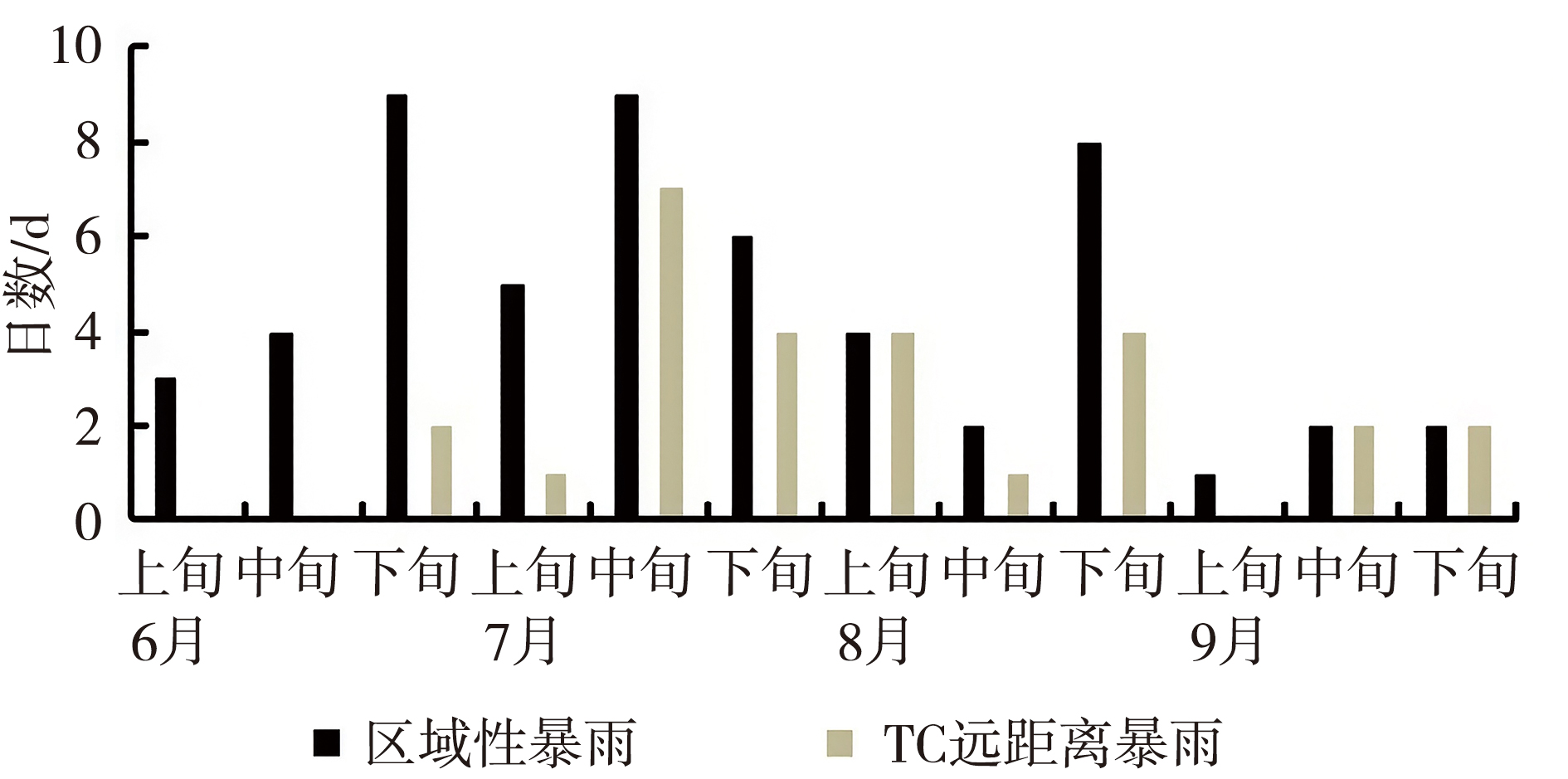
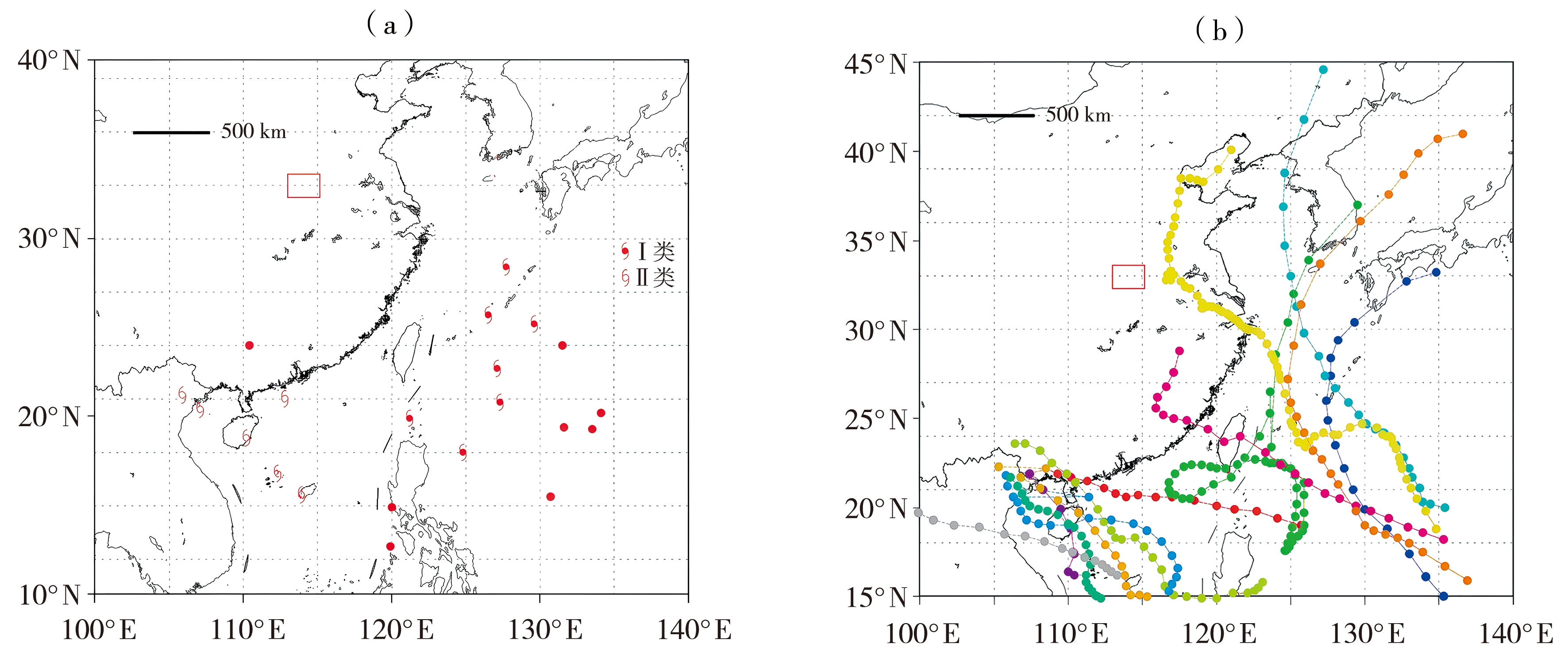
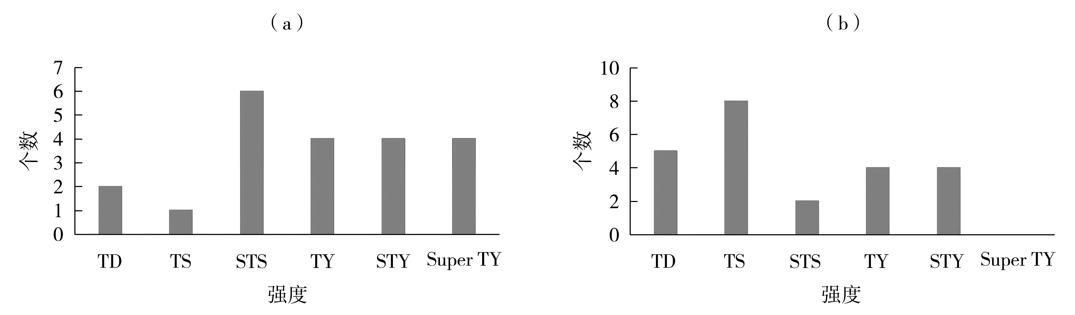
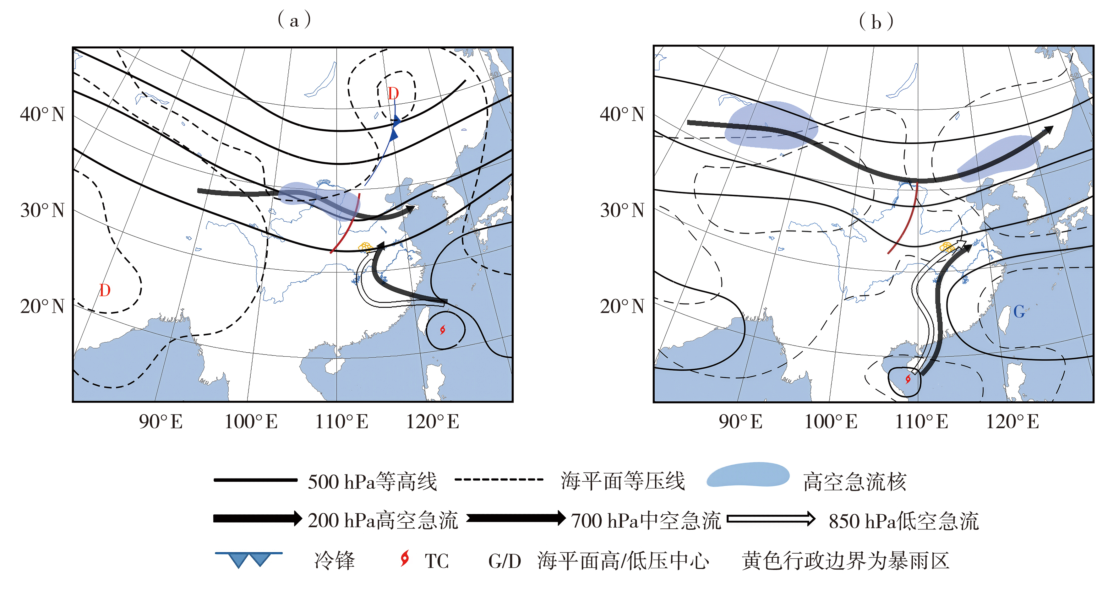
利用地面常规气象观测资料、中国气象局最佳热带气旋(Tropical Cyclone,TC)路径数据集、美国国家环境预测中心/美国国家大气研究中心(National Centers for Environmental Prediction/National Centers for Atmospheric Reasearch,NCEP/NCAR)再分析资料以及拉格朗日混合单粒子轨道模型(Hybrid Single-Particle Lagrangian Integrated Trajectory Model,HYSPLIT),对2001—2023年影响驻马店的热带气旋远距离暴雨进行统计与合成分析。结果表明,驻马店市远距离暴雨(Tropical Cyclone Remote Precipitation,TRP)主要发生于7月中下旬及8月,多出现在TC强度增强或最强阶段。根据TC中心位置的分布特征,将远距离暴雨分为两类。合成分析结果显示,影响驻马店市TRP的主要环流系统包括TC、副热带高压、西风槽配置以及高、低空急流。两类TRP过程的背景差异主要体现在TC、副热带高压和西风槽的位置配置及水汽来源路径上。TRP发生前24 h,两类过程均表现为高层辐散、低层辐合的环流结构,但其强度均弱于TRP发生时刻。关键影响系统的相对位置以及远距离TC能否与本地建立有效的水汽输送通道,对TRP的发生具有决定性作用;同时,高、低空急流耦合所激发的垂直运动是决定暴雨强度的关键动力因素。在此基础上,归纳并提出了两类热带气旋远距离暴雨过程的预报思路。

关键词: TC远距离暴雨, 统计特征, 预报思路, 驻马店

Abstract:

Using conventional ground-based meteorological observations, the China Meteorological Administration (CMA) best-track dataset of tropical cyclones (TCs), the National Centers for Environmental Prediction/National Centers for Atmospheric Research (NCEP/NCAR) reanalysis data, and the Hybrid Single-Particle Lagrangian Integrated Trajectory (HYSPLIT) model, statistical and composite analyses were conducted for tropical cyclone remote precipitation (TRP) events affecting Zhumadian during 2001-2023. The results show that TRP events in Zhumadian mainly occur from mid to late July and in August, and most of them are associated with the TC intensification or mature stages. According to the spatial distribution characteristics of TC center locations, the TRP events are classified into two types. Composite analyses indicate that the primary circulation systems influencing TRP in Zhumadian include the TC, subtropical high, and midlatitude westerly trough configuration, as well as upper- and lower-level jet streams. The background differences between the two TRP types are mainly reflected in the relative positions of the TC, subtropical high, and westerly trough, as well as in the moisture transport pathways. At 24 hours prior to TRP occurrence, both types exhibit a circulation pattern characterized by upper-level divergence and lower-level convergence, but the intensity is weaker than that at the time of TRP occurrence. Further analysis reveals that the relative positions of the key influencing systems and whether a remote TC can establish an effective moisture transport channel with the local region play a decisive role in the occurrence of TRP. Meanwhile, the vertical motion induced by the coupling of upper- and lower-level jet streams is the key dynamical factor controlling TRP intensity. Based on these results, forecasting approaches for the two types of TRP events in Zhumadian are summarized.

Key words: tropical cyclone remote precipitation, statistical characteristics, forecasting approaches, Zhumadian

中图分类号: