干旱气象 ›› 2025, Vol. 43 ›› Issue (4): 627-636.DOI: 10.11755/j.issn.1006-7639-2025-04-0627

• 论文 • 上一篇    下一篇

风廓线雷达资料在一次对流暴雨过程中的特征分析

王文波1(), 李晓利1(), 曹云飞2, 杨明2, 高晓梅1, 杨萌1   

  1. 1.山东省潍坊市气象局,山东 潍坊 261011
    2.民航安徽空管分局,安徽 合肥 230051
  • 收稿日期:2024-10-11 修回日期:2024-11-20 出版日期:2025-08-31 发布日期:2025-09-08
  • 通讯作者: 李晓利(1980—),女,湖南湘潭人,高级工程师,主要从事气象数据分析与应用工作。E-mail: xiaoli4114@163.com
  • 作者简介:王文波(1987—),男,山东潍坊人,高级工程师,主要从事天气预报研究。E-mail: sdwfwwb@163.com
  • 基金资助:
    山东省自然科学基金项目(ZR2023MD118);山东省气象局重点课题项目(2023sdqxz10);山东省气象局重大天气专项(SDTQ2023-06);中国气象局复盘总结专项(FPZJ2025-074);山东省气象局预报员专项(SDYBY2020-07)

Characteristic analysis of wind profile radar data in a convective rainstorm

WANG Wenbo1(), LI Xiaoli1(), CAO Yunfei2, YANG Ming2, GAO Xiaomei1, YANG Meng1   

  1. 1. Weifang Meteorological Bureau of Shandong Province, Weifang 261011, Shangdong, China
    2. Civil Aviation Atc Substation in Anhui, Hefei 230051, China
  • Received:2024-10-11 Revised:2024-11-20 Online:2025-08-31 Published:2025-09-08

摘要:

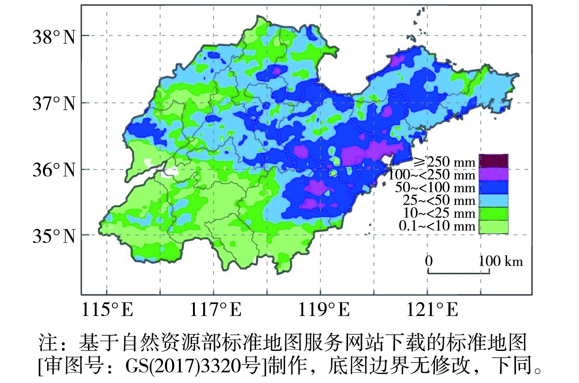
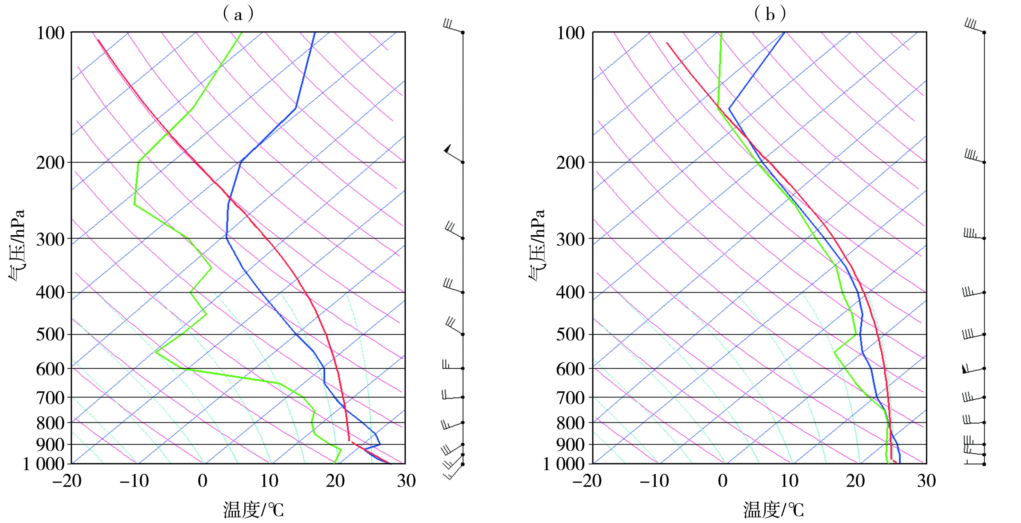
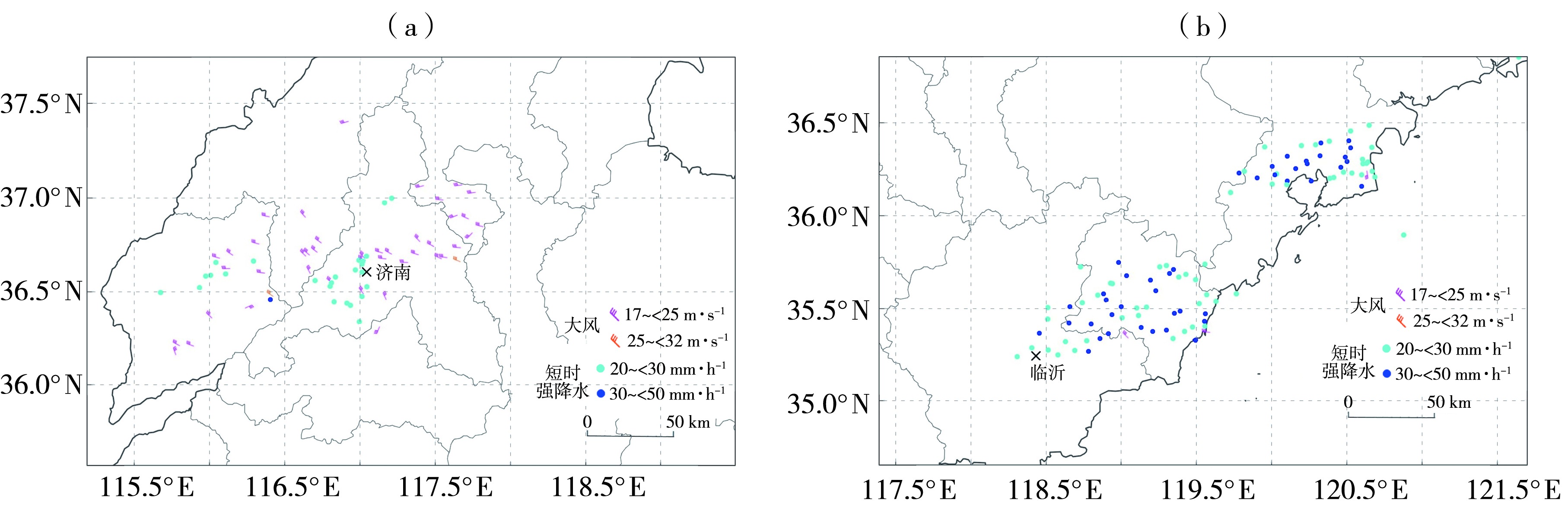
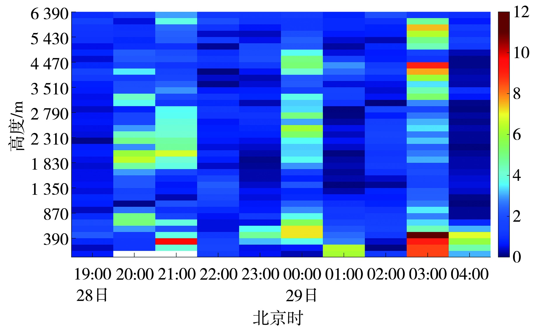
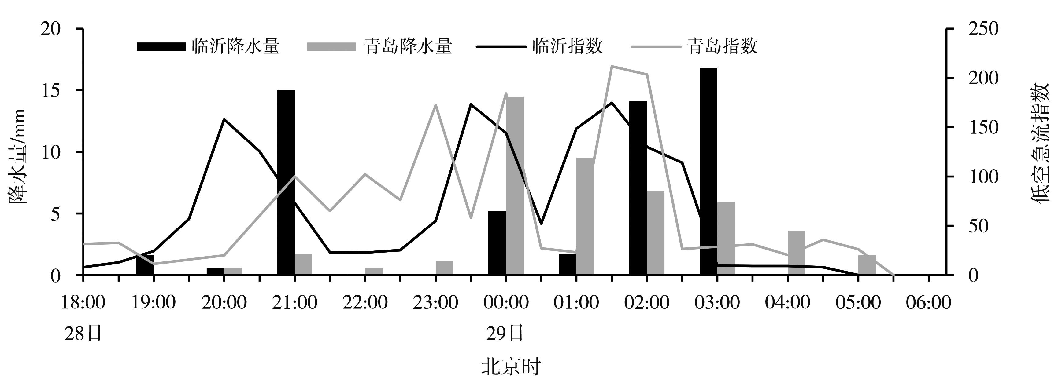
高时空分辨率的风廓线雷达资料在短时降水的临近预报预警中具有重要价值。基于常规气象观测、区域站资料、美国国家环境预报中心(National Center for Environmental Prediction,NCEP)再分析资料及风廓线雷达组网数据,对2023年山东入汛以来首场大范围暴雨过程进行分析,结果表明,此次过程受高空槽、低涡、低空急流及中尺度切变线共同影响,6月27日为暖区对流,28日以低涡引发的短时强降水为主;强降水主要位于中尺度切变线右侧的正涡度平流区及辐合中心上空,低层辐合与高层辐散的垂直配置为强对流发生提供动力条件;1 km以下超低空风场变化对强降水具有指示意义,低空急流下探及水平风脉动与降水强度呈一定正相关;强降水前1.0 h内低空急流指数与垂直风切变明显增强,降水结束前风切变迅速减弱,近地层出现强切变,风廓线雷达在识别短时强降水临近特征方面具有明显优势。

关键词: 风廓线雷达, 暴雨, 中尺度切变线, 低空急流

Abstract:

High spatiotemporal resolution wind profile radar data are of significant value in the nowcasting and early warning of short-duration heavy precipitation. Based on conventional meteorological observations, regional automatic station data, reanalysis data from the National Centers for Environmental Prediction (NCEP), and wind profile radar network observations, this study analyzes the first large-scale heavy rainstorm event in Shandong Province following the onset of the 2023 flood season. The results indicate that, this event was jointly influenced by an upper-level trough, a low vortex, a low-level jet (LLJ), and a mesoscale shear line. Convection on June 27 occurred in the warm sector, while short-duration heavy rainfall on June 28 was primarily induced by the low vortex. The heavy precipitation mainly occurred on the right side of the mesoscale shear line, within regions of positive vorticity advection and above convergence centers. The vertical configuration of low-level convergence and upper-level divergence provided favorable dynamic conditions for strong convection. Variations in the near-surface wind field below 1 km were indicative of heavy rainfall. The downward extension of the LLJ and enhanced horizontal wind perturbations were positively correlated with precipitation intensity. Within 1 hour prior to the onset of heavy rainfall, both the LLJ index and vertical wind shear increased significantly. Before the cessation of rainfall, vertical wind shear weakened rapidly, and strong low-level shear appeared near the surface. Wind profile radar showed clear advantages in identifying precursor signatures for nowcasting short-duration heavy rainfall events.

Key words: wind profile radar, rainstorm, mesoscale shear line, low-level jet

中图分类号: