干旱气象 ›› 2024, Vol. 42 ›› Issue (4): 588-597.DOI: 10.11755/j.issn.1006-7639(2024)-04-0588

• 论文 • 上一篇    下一篇

台风“安比”变性机制及其对内蒙古大暴雨影响的数值模拟研究

林弘杰1(), 文小航2, 黄晓璐3(), 李瑞青4   

  1. 1.内蒙古自治区气象科学研究所,内蒙古 呼和浩特 010051
    2.成都信息工程大学大气科学学院,四川 成都 610225
    3.内蒙古自治区气象台,内蒙古 呼和浩特 010051
    4.内蒙古大学,内蒙古 呼和浩特 010021
  • 收稿日期:2024-03-15 修回日期:2024-06-07 出版日期:2024-08-31 发布日期:2024-09-13
  • 通讯作者: 黄晓璐(1991—),女,内蒙古赤峰人,高级工程师,主要从事短时临近预报及强对流机理研究。E-mail: 674222133@qq.com
  • 作者简介:林弘杰(1992—),男,内蒙古呼和浩特人,工程师,主要从事天气预报及数值模式应用研究。E-mail: 407649759@qq.com
  • 基金资助:
    内蒙古自治区自然科学基金青年基金项目(2023QN04008);内蒙古自治区气象局科技创新项目(nmqxkjcx202462);内蒙古自治区自然科学基金面上项目(2023MS04008)

Numerical simulation study of Typhoon “Ambi” degeneration mechanism and its impact on heavy rainstorm in Inner Mongolia

LIN Hongjie1(), WEN Xiaohang2, HUANG Xiaolu3(), LI Ruiqing4   

  1. 1. Inner Mongolia Institute of Meteorological Sciences, Hohhot 010051, China
    2. College of Atmospheric Sciences, Chengdu University of Information Technology, Chengdu 610225, China
    3. Inner Mongolia Autonomous Region Meteorological Observatory, Hohhot 010051, China
    4. Inner Mongolia University, Hohhot 010021, China
  • Received:2024-03-15 Revised:2024-06-07 Online:2024-08-31 Published:2024-09-13

摘要:

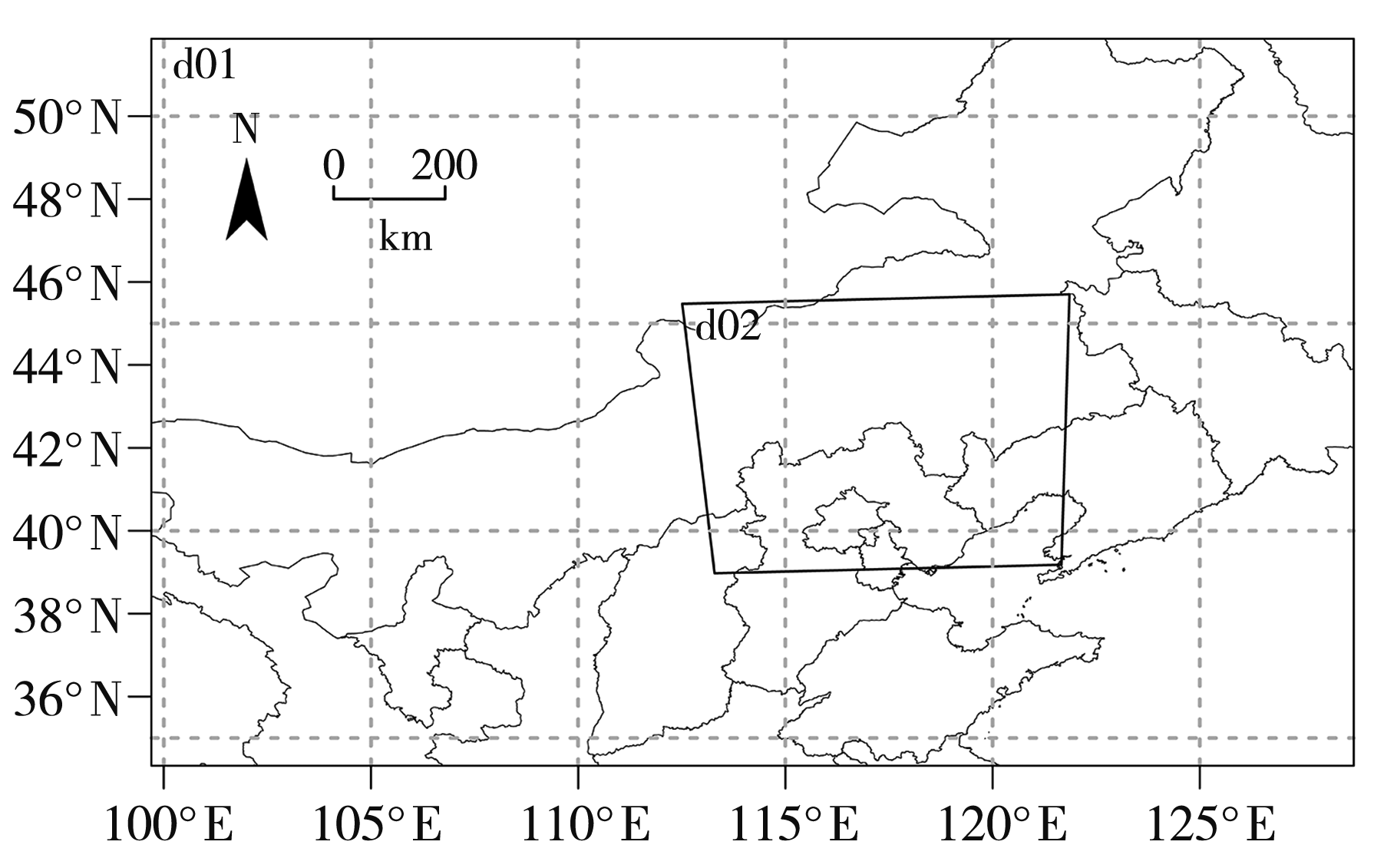
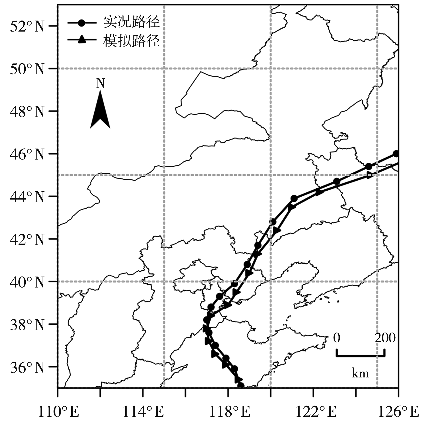
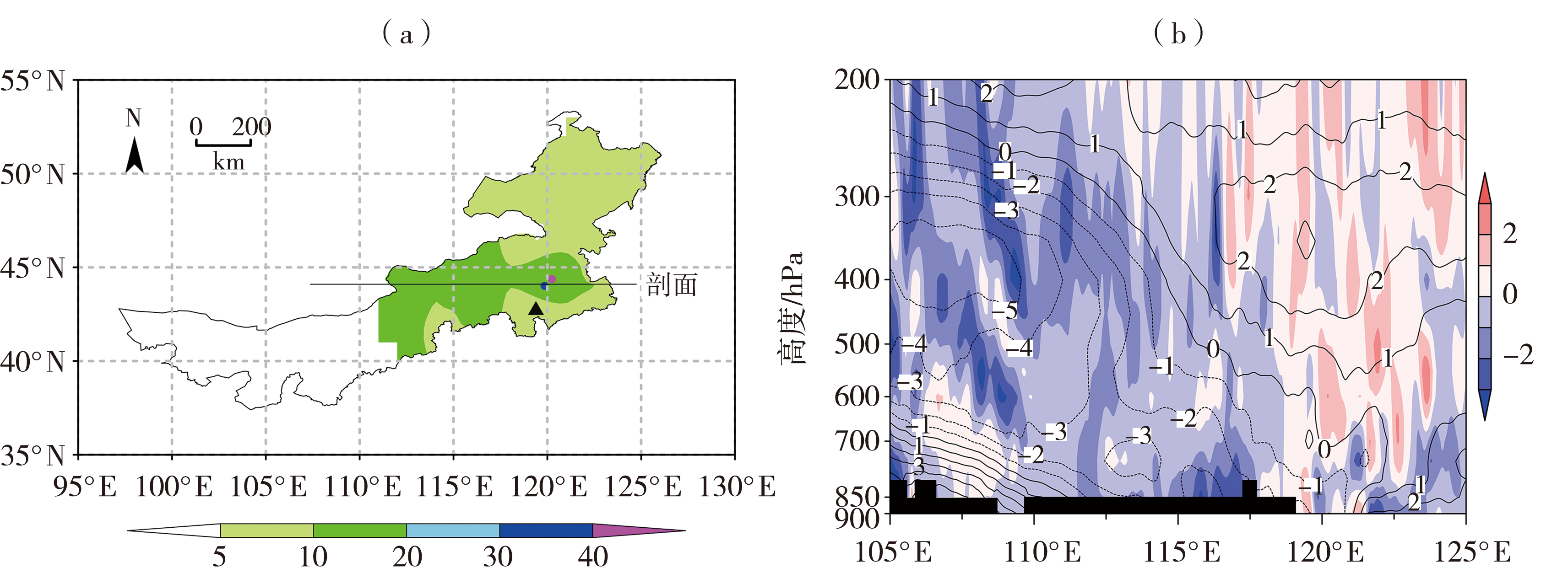
台风“安比”是首个进入内蒙古的热带气旋,引发了该地区中东部的罕见致灾性大暴雨。本文利用中尺度数值预报模式(Weather Research Forecast,WRF)输出的模拟结果、美国国家环境预报中心/国家大气研究中心(National Centers for Environmental Prediction/National Center for Atmospheric Research,NCEP/NCAR)再分析资料、台风路径数据及常规观测资料等,对“安比”北上过程中的变性机制及其对内蒙古大暴雨天气的影响进行了分析。结果显示:大暴雨过程的大尺度环流背景是台风与中高纬西风带高空槽的相互作用,西风槽提供的冷空气与台风的暖湿气流交汇引发了此次大暴雨;在西风槽并入台风的过程中,冷空气自西向东楔入并向下扩散东移,产生强烈的冷平流,推动暖湿空气抬升,破坏了台风的正压暖心结构,并形成“东暖西冷”的不对称温度结构,导致台风变性为温带气旋;主要的降水区域位于MPV1正值区与MPV2负值区的重叠区,区域的对流不稳定和斜压不稳定能量积聚,促进强降水的发展;冷暖空气的交汇区出现强锋生作用,形成明显锋区,为大暴雨提供动力条件,锋生带附近有明显次级环流圈形成,锋前为上升气流,锋后为下沉气流,强降水区域对应上升气流最强区域。

关键词: 台风“安比”, 大暴雨, 变性, 数值模拟, 内蒙古

Abstract:

Typhoon “Ambi” was the first tropical cyclone to enter Inner Mongolia, causing rare catastrophic heavy rainstorm in the central and eastern parts of the region. This paper analyzes the transformation mechanism of “Ambi” during its northward movement and its impact on the heavy rainfall weather in Inner Mongolia using simulation results from the mesoscale numerical forecasting model (Weather Research Forecast, WRF), reanalysis data from the National Centers for Environmental Prediction/National Center for Atmospheric Research (NCEP/NCAR), typhoon path data, and routine observational data. The results indicate that the large-scale atmospheric circulation background of the heavy rainstorm was the interaction between the typhoon and the mid-to-high latitude westerly trough, where the cold air provided by the westerly trough met with the warm and moist airflow of the typhoon, triggering this heavy rainfall event. During the process of the westerly trough merging with the typhoon, cold air intruded from west to east and moved downward, generating a strong cold advection that lifted the warm and moist air, disrupted the barotropic warm core structure of the typhoon, and formed an asymmetric temperature structure of “warm in the east and cold in the west”, transforming the typhoon into an extratropical cyclone. The main precipitation area was located in the overlapping zone of positive MPV1 and negative MPV2 values, where the accumulation of convective instability and baroclinic instability energy promoted the development of intense precipitation. In the region where cold and warm air intersected, strong frontogenesis occurred, forming a distinct frontal zone, which provided the dynamical conditions for heavy rainstorm. Near the frontal band, a noticeable secondary circulation developed, with ascending airflow at the front and descending airflow at the rear, with the area of strongest precipitation corresponding to the region of strongest ascending airflow.

Key words: Typhoon “Ambi”, heavy rainstorm, degeneration, numerical simulation, Inner Mongolia

中图分类号: