干旱气象 ›› 2025, Vol. 43 ›› Issue (5): 713-722.DOI: 10.11755/j.issn.1006-7639-2025-05-0713

• 论文 • 上一篇    下一篇

“杜苏芮”台风过程中莆田市特大暴雨阶段性和强度特征

黄丽娜1,2(), 陈艳真1, 陈宇航1, 李忆平3(), 杨明灿1, 陈诗琳4   

  1. 1.福建省莆田市气象局,福建 莆田 351180
    2.中国气象局海峡灾害天气重点开放实验室,福建 福州 350008
    3.中国气象局兰州干旱气象研究所,甘肃省干旱气候变化与减灾重点实验室,中国气象局干旱气候变化与减灾重点实验室,甘肃 兰州 730020
    4.福建省莆田市城厢区气象局,福建 城厢 351100
  • 收稿日期:2025-01-16 修回日期:2025-04-14 出版日期:2025-10-31 发布日期:2025-11-09
  • 通讯作者: 李忆平(1981—),女,主要从事气候监测及其机理研究。E-mail: liyiping532@163.com
  • 作者简介:黄丽娜(1971—),女,正高级工程师,主要从事天气预报研究。E-mail: lenah@163.com
  • 基金资助:
    福建省自然科学基金项目(2022J011074);中国气象局复盘专项(FPZJ2024-066)

Characteristics of stages and intensity of a severe torrential rainfall in Putian City during Typhoon “Doksuri”

HUANG Lina1,2(), CHEN Yanzhen1, CHEN Yuhang1, LI Yiping3(), YANG Mingcan1, CHEN Shilin4   

  1. 1. Putian Meteorological Bureau of Fujian, Putian 351180, Fujian, China
    2. Key Open Laboratory of Straits Severe Weather, China Meteorological Administration, Fuzhou 350008, China
    3. Institute of Arid Meteorology, China Meteorological Administration, Key Laboratory of Arid Climatic Change and Reducing Disaster of Gansu Province, Key Laboratory of Arid Climatic Change and Disaster Reduction of CMA, Lanzhou 730020, China
    4. Chengxiang Meteorological Bureau of Fujian, Chengxiang 351100, Fujian, China
  • Received:2025-01-16 Revised:2025-04-14 Online:2025-10-31 Published:2025-11-09

摘要:

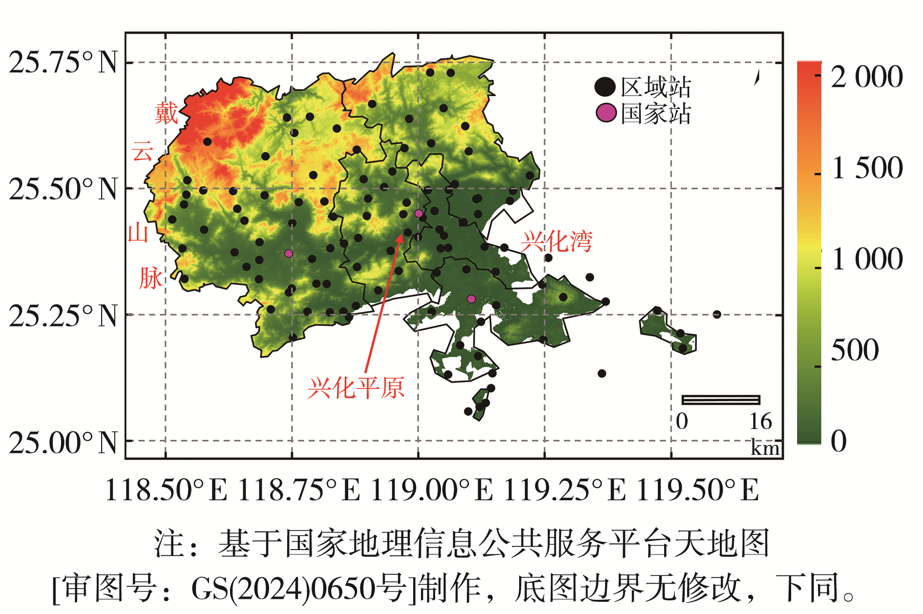
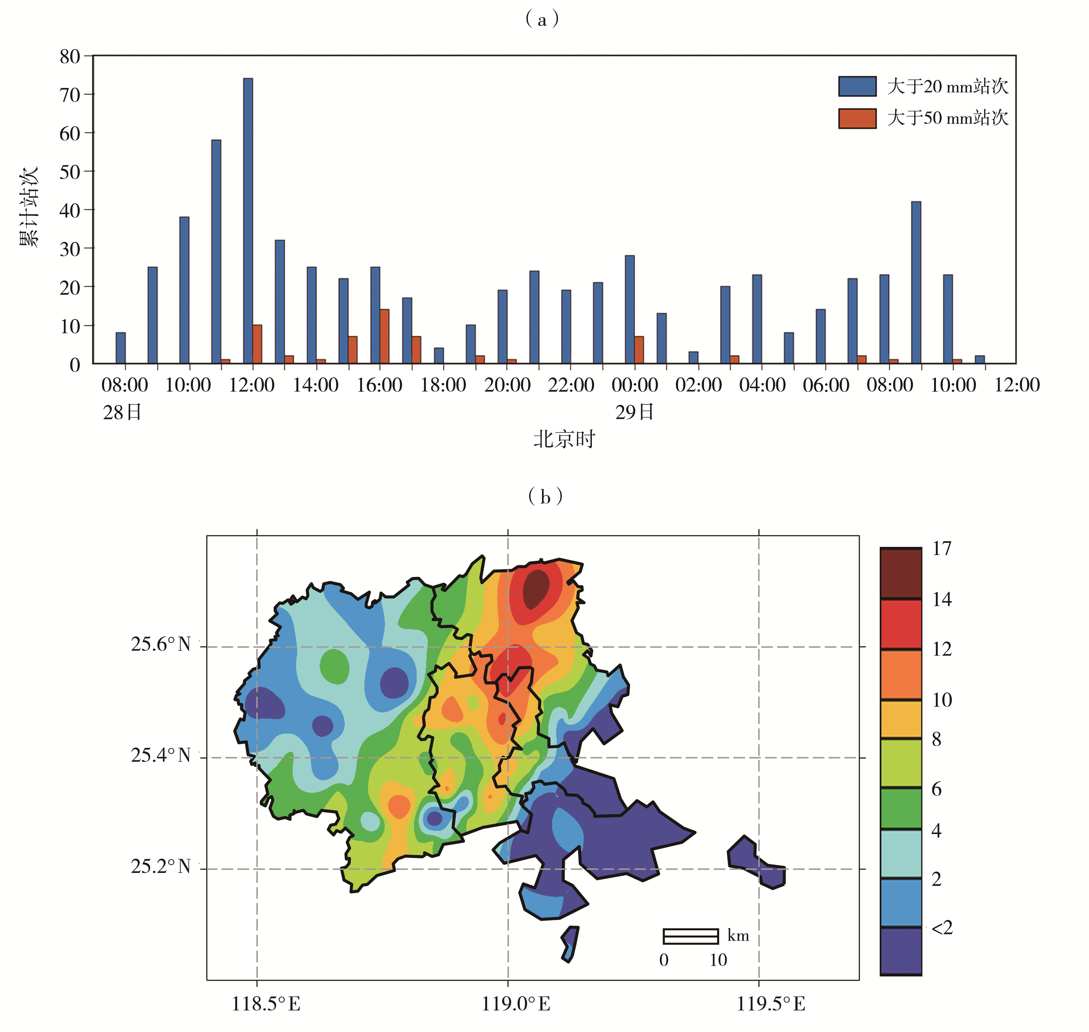
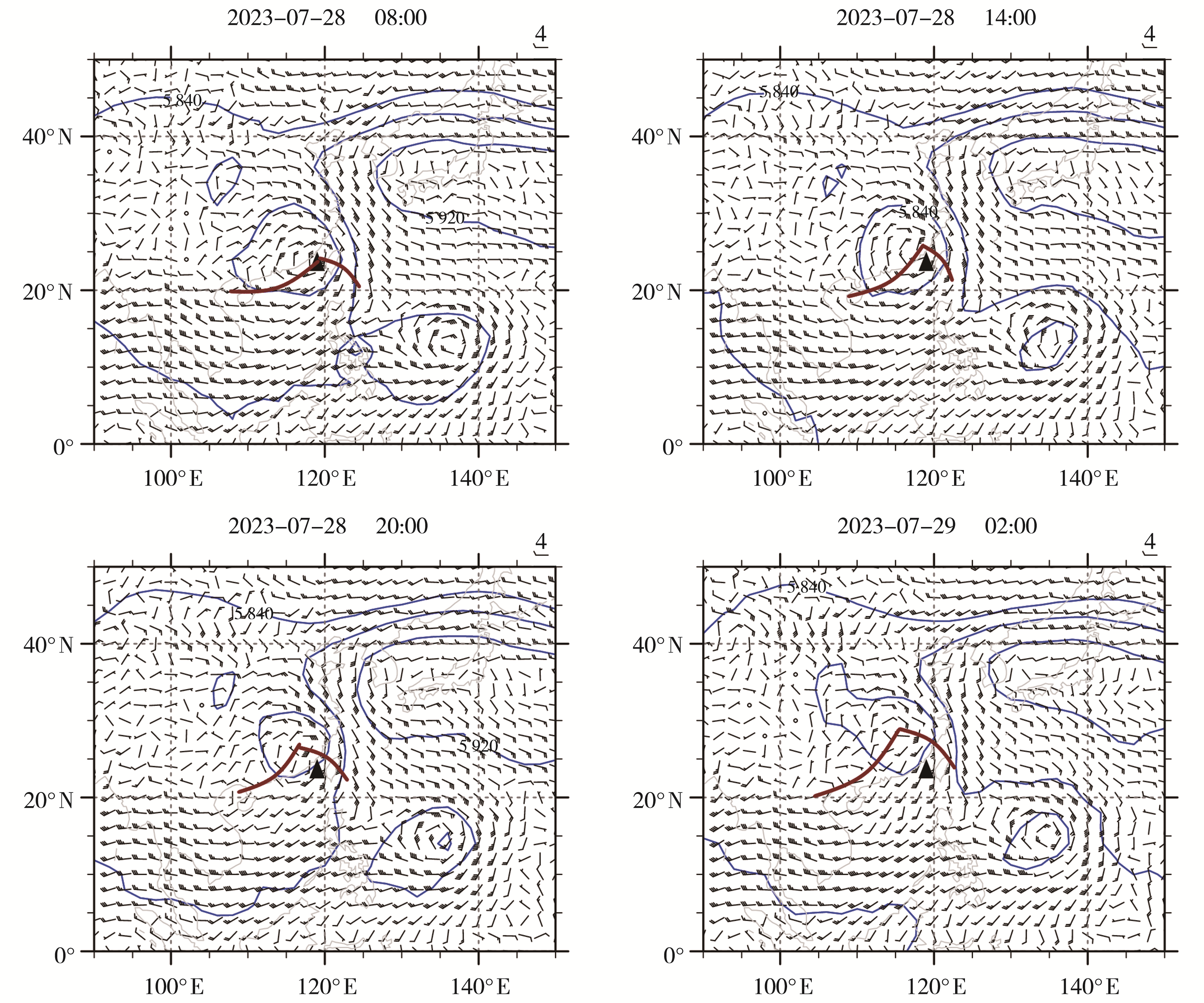
2023年第5号台风“杜苏芮”(2305)造成福建省莆田市罕见特大暴雨。本文利用福建省地面气象观测数据、雷达和卫星等多源观测资料及欧洲中期天气预报中心(European Centre for Medium-Range Weather Forecasts,ECMWF)再分析资料,分析“杜苏芮”引发的莆田市特大暴雨的阶段性和强度特征。结果表明:本次过程由3个暴雨阶段以“无缝衔接”的形式组成,第一阶段为台风眼壁暴雨,具有短时雨强较强、空间分布均匀的特点;第二阶段为螺旋雨带暴雨,具有小时雨强差异显著、雨峰明显的特点;第三阶段为季风暴雨,具有暴雨范围广、持续时间长的特点。“杜苏芮”引发的莆田暴雨极端性显著,具体表现为:暴雨强度强、特大暴雨影响范围广、累计雨量大、短时强降水发生频次高且持续时间长。其中,莆田站24 h雨量达561.7 mm,突破福建省历史最高记录,极端性特征尤为突出。台风暖式切变线、低空南风急流和季风等系统持续维持,是三个阶段暴雨实现“无缝衔接”的重要天气背景,兴化平原“三面环山、向南开口”的地形对南风急流的抬升和收缩作用是暴雨中心位于兴化平原至东北部山区的重要因素。

关键词: “杜苏芮”台风, 特大暴雨, 极端性, 短时强降水, 兴化平原

Abstract:

Typhoon Doksuri (No.2305) caused an extremely rare torrential rainfall over Putian City, Fujian Province. Based on multi-source observational data, including surface meteorological observational data of Fujian Province, radar and satellite data, as well as reanalysis data from ECMWF (European Centre for Medium-Range Weather Forecasts), the stages and intensity characteristics of the extreme rainfall induced by Typhoon Doksuri were analyzed. The main conclusions are as follows: The entire rainfall process was consisted of three seamlessly-linked stages. The first stage was the typhoon eyewall rainstorm, which had the characteristics of intense short-term rainfall and uniform spatial distribution. The second stage was the spiral rainband rainstorm, which was characterized by significant differences in hourly rainfall intensity and distinct rain peaks. The third stage was the monsoon-enhanced rainstorm, with the characteristics of a wide range of heavy rain and a long duration. The heavy rain in Putian caused by Typhoon Doksuri exhibits remarkable extremeness, with specific manifestations as follows: extremely intense heavy rainfall, a wide impact range of extremely heavy rainfall, large cumulative rainfall, high frequency of short-term heavy precipitation, and long duration. Among these, the 24-hour rainfall at Putian Station reached 561.7 mm, breaking the historical record of Fujian Province, and its extreme characteristics are particularly prominent. The continuous maintenance of typhoon warm shear line, low-level southerly jet and monsoon system is an important weather background for the three stages of rainstorm to achieve “seamless connection”. The uplift and contraction of the southerly jet caused by the terrain of Xinghua Plain “surrounded by mountains on three sides and opening to the south” is an important factor for the rainstorm center to be located in the Xinghua Plain to the northeast mountainous area.

Key words: typhoon “Doksuri”, extreme rainfall, extremity, short-duration heavy rainfall, Xinghua Plain

中图分类号: