干旱气象 ›› 2023, Vol. 41 ›› Issue (4): 629-638.DOI: 10.11755/j.issn.1006-7639(2023)-04-0629

• 论文 • 上一篇    下一篇

云南一次强对流暴雨天气学成因分析

马志敏1,3(), 王将4, 连钰1,3, 张万诚2,3, 牛法宝1,3(), 杨素雨1,3   

  1. 1.云南省气象台,云南 昆明 650034
    2.云南省气象科学研究所,云南 昆明 650034
    3.中国气象局横断山区低纬高原灾害性天气研究中心,云南 昆明 650034
    4.云南省昆明市气象局,云南 昆明 650501
  • 收稿日期:2021-10-22 修回日期:2022-02-18 出版日期:2023-08-31 发布日期:2023-08-29
  • 通讯作者: 牛法宝(1972—),男,高级工程师,主要从事天气预报及服务工作。E-mail: 729441981@qq.com。
  • 作者简介:马志敏(1984—),男,高级工程师,主要从事天气预报及数值模拟研究。E-mail:413931483@qq.com
  • 基金资助:
    国家自然基金项目(41765003);国家自然基金项目(42075013);国家自然基金项目(42365007);云南省气象局创新团队项目(2022CX01);中国气象局复盘专项(FPZJ2023-119)

Analysis on synoptic causes of a severe convective rainstorm in Yunnan

MA Zhimin1,3(), WANG Jiang4, LIAN Yu1,3, ZHANG Wancheng2,3, NIU Fabao1,3(), YANG Suyu1,3   

  1. 1. Yunnan Meteorological Observatory, Kunming 650034, China
    2. Yunnan Institute of Meteorological Sciences, Kunming 650034, China
    3. Research Center for Disastrous Weather over Hengduan Mountains Low-Latitude Plateau, CMA, Kunming 650034, China
    4. Kunming Meteorological Bureau of Yunnan Province, Kunming 650501, China
  • Received:2021-10-22 Revised:2022-02-18 Online:2023-08-31 Published:2023-08-29

摘要:

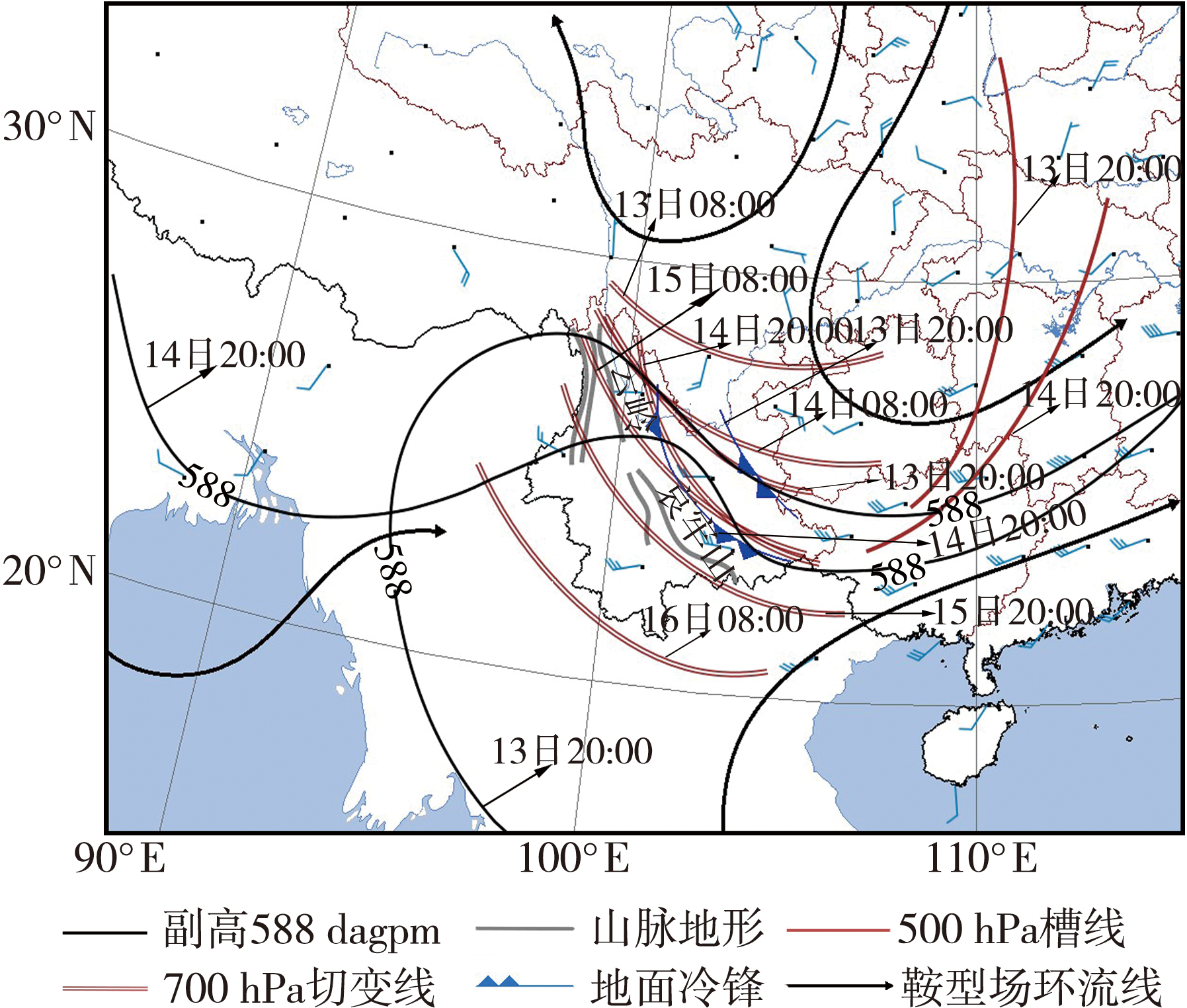
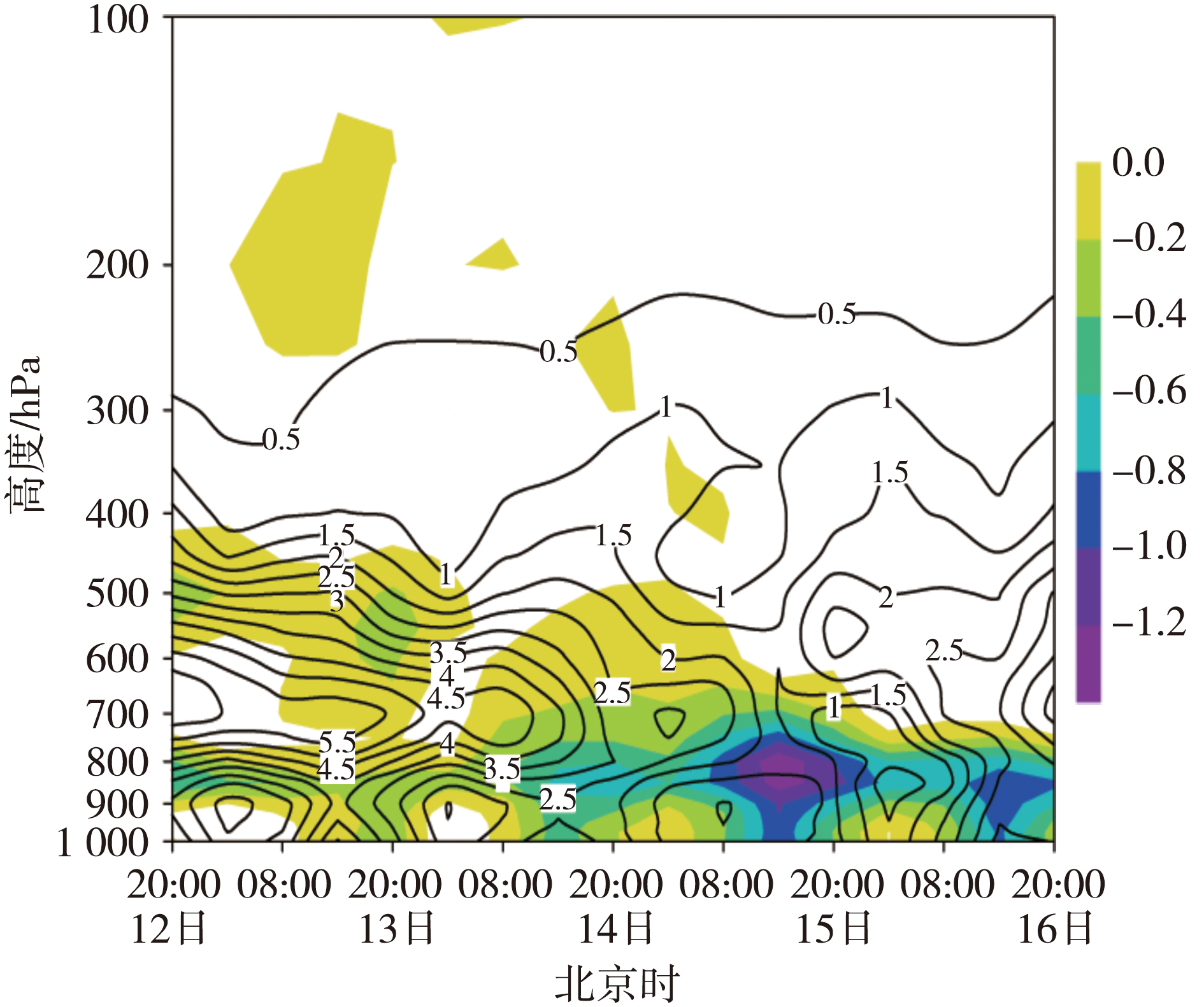
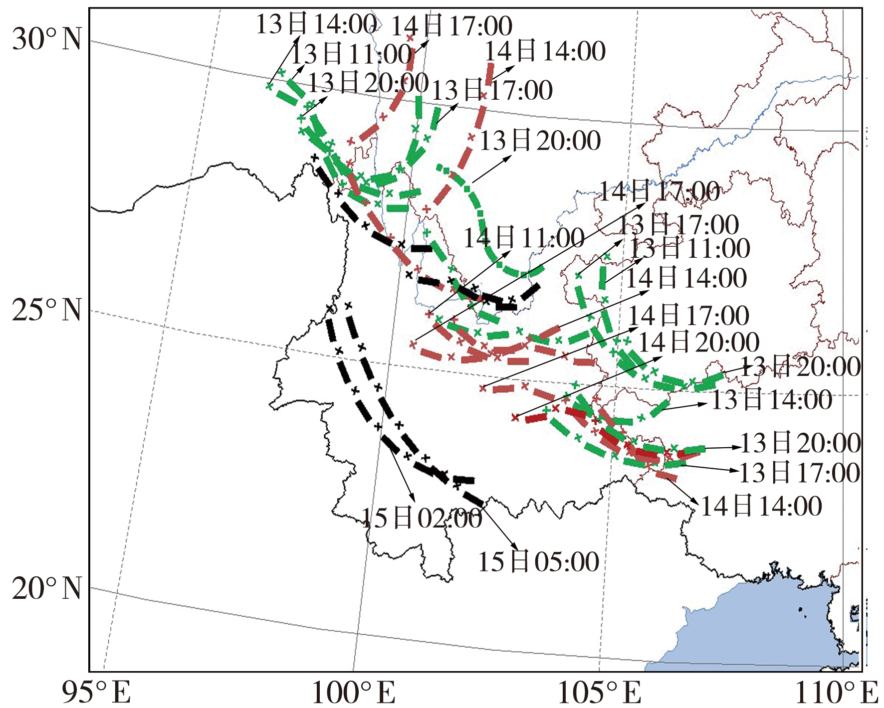
为提高暴雨预报准确率,减少暴雨致灾损失,基于地面常规气象观测资料、卫星云图反演的云顶亮温(Black Body Temperature, TBB)资料及美国国家环境预报中心(National Centers for Environmental Prediction, NCEP)再分析资料,对2017年8月云南一次强对流暴雨成因进行分析。结果表明:500 hPa低槽东移、700 hPa切变线南压、地面冷锋西推是此次降水过程发生的天气背景;中-β、中-α尺度对流系统(Mesoscale Convective System, MCS)是产生强对流暴雨的直接系统,强降雨主要出现在TBB梯度大值区;MCS与700 hPa切变线关系最为密切,切变线位于滇中以东地区,MCS呈椭圆状,沿切变线附近及后部发展,切变线靠近哀牢山或翻越后,MCS呈西北—东南向带状分布,沿切变线前部发展;切变线翻越哀牢山前,白天移动较快,主要产生雷暴天气,夜间移动缓慢,降雨较强;强对流暴雨需重点关注水汽通量辐合大值区、800 hPa与500 hPa温差大于20 ℃区域;强降雨时段,整层大气均为上升运动,强降雨区维持低层辐合、中高层辐散的动力抽吸机制。

关键词: 强对流暴雨, 短时强降水, 切变线, MCS

Abstract:

In order to improve the accuracy of rainstorm forecast and reduce the disaster losses caused by rainstorm, based on the ground conventional meteorological observation data, TBB (Black Body Temperature) data from satellite images and reanalysis data from National Centers for Environmental Prediction (NCEP), the synoptic causes of a strong convective rainstorm in Yunnan in August 2017 were analyzed. The results show that the eastward movement of 500 hPa trough, the southward movement of 700 hPa shear line and the westward movement of surface cold front are the synoptic background of this precipitation process. The mesoscale convective systems (MCS) on the Meso-α and Meso-β scales directly trigger the convective rainstorm. The heavy rainfall generally happens in the region with a high gradient of TBB. The MCS is closely related to 700 hPa wind shear line where is located to the east of Mid-Yunnan. The MCS is elliptically-shaped, developing along the neighboring and backside of the wind shear line. After the wind shear line getting close and cross over the Ailao Mountain, the MCSs distribute in a belt from northwest to southeast, and develop in front of the wind shear line. The wind shear line moves fast during the daytime before crossing over the Ailao Mountain, mainly producing thunderstorm weather while it moves slowly at nighttime, and the rainfall is strong. The forecast of strong convective rainstorm should focus on the large value area of water vapor flux convergence and the area where the temperature difference between 800 hPa and 500 hPa is greater than 20 ℃. During the heavy rainfall, the whole layer atmosphere is ascending, and the heavy rainfall area maintains the dynamic pumping mechanism of convergence at lower level and divergence at middle and upper levels.

Key words: severe convective rainstorm, short-term heavy rainfall, shear line, MCS

中图分类号: