干旱气象 ›› 2022, Vol. 40 ›› Issue (4): 656-666.DOI: 10.11755/j.issn.1006-7639(2022)-04-0656
西太平洋副热带高压控制下湖南一次短时强降水成因分析
兰明才1,2( ), 周莉1,2(), 蒋帅3, 尹依雯3, 许霖1
- 1. 湖南省气象台,湖南 长沙 410118
2. 气象防灾减灾湖南省重点实验室,湖南 长沙 410118
3. 湖南省岳阳市气象局,湖南 岳阳 414000
-
收稿日期:2021-07-15修回日期:2022-02-24出版日期:2022-08-31发布日期:2022-09-22 -
通讯作者:周莉 -
作者简介:兰明才(1984—),男,高级工程师,主要从事天气预报预测及短时临近预报预警技术研究. E-mail: 372917798@qq.com。 -
基金资助:湖南省自然科学基金项目-青年基金(2022JJ40214);湖南省气象局研究型业务预报预测专项(XQKJ21C009);泛珠三角科技创新开放基金(FZSJ202104);2019年度湖南省重点领域研发计划项目(2019SK2161);2021年中国气象局创新发展专项(CXFZ2021J020);湖南省气象局2022年重点课题(XQKJ22A005)
Causes of a short-term heavy rainfall under the control of the western Pacific subtropical high in Hunan Province
LAN Mingcai1,2(), ZHOU Li1,2(), JIANG Shuai3, YIN Yiwen3, XU Lin1
- 1. Hunan Meteorological Observatory, Changsha 410118, China
2. Key Laboratory of Preventing and Reducing Meteorological Disaster in Hunan Province, Changsha 410118, China
3. Yueyang Meteorological Bureau of Hunan Province, Yueyang 414000, Hunan, China
-
Received:2021-07-15Revised:2022-02-24Online:2022-08-31Published:2022-09-22 -
Contact:ZHOU Li
摘要:
在天气预报业务中,发生在西太平洋副热带高压控制下的短时强降水容易出现漏报。为加深对西太平洋副热带高压控制下湖南短时强降水的认识,探究其成因和触发机制,本文利用地面自动站、多普勒天气雷达观测资料及FY-2F云顶亮温、NCEP再分析资料等,针对2018年9月6日一次西太平洋副热带高压控制下的湖南短时强降水成因开展研究。结果表明:在强盛的西太平洋副热带高压脊区内,丰沛的水汽、较强的不稳定能量及一定的抬升条件可触发短时强降水天气。正午前,受弱冷空气侵入影响,低层切变配合地面中尺度辐合线引起近地面动力抬升,从而触发对流性降水;午后,受太阳辐射影响,地面气温达到对流触发温度,从而触发热对流。正涡度区及低层辐合区在降水发生后都向上延伸,有利于垂直上升运动的维持,但较典型汛期强降水过程的动力条件明显偏弱。环境风及其垂直风切变小,且雷暴单体移动缓慢,有利于强降水在同一地区长时间维持。
中图分类号:
引用本文
兰明才, 周莉, 蒋帅, 尹依雯, 许霖. 西太平洋副热带高压控制下湖南一次短时强降水成因分析[J]. 干旱气象, 2022, 40(4): 656-666.
LAN Mingcai, ZHOU Li, JIANG Shuai, YIN Yiwen, XU Lin. Causes of a short-term heavy rainfall under the control of the western Pacific subtropical high in Hunan Province[J]. Journal of Arid Meteorology, 2022, 40(4): 656-666.
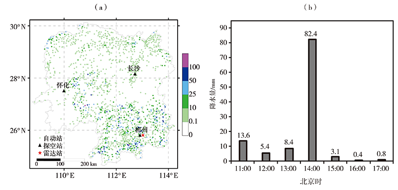
图1 2018年9月6日07:00—20:00湖南省自动站累计雨量(a,单位:mm)和11:00—17:00三十六湾站逐小时降水量(b)
Fig.1 The accumulative precipitation at automatic weather stations of Hunan Province from 07:00 BST to 20:00 BST (a, Unit: mm) and hourly precipitation at Sanshiliuwan station from 11:00 BST to 17:00 BST (b) on September 6, 2018
图1 2018年9月6日07:00—20:00湖南省自动站累计雨量(a,单位:mm)和11:00—17:00三十六湾站逐小时降水量(b)
Fig.1 The accumulative precipitation at automatic weather stations of Hunan Province from 07:00 BST to 20:00 BST (a, Unit: mm) and hourly precipitation at Sanshiliuwan station from 11:00 BST to 17:00 BST (b) on September 6, 2018
表1 2018年9月6日07:00—20:00湖南省区域自动站降水统计
Tab.1 The statistics of rainfall at regional automatic weather stations of Hunan Province from 07:00 BST to 20:00 BST on September 6, 2018
| 时 间 | 1 h内 | 时 间 | 3 h内 | |||||
|---|---|---|---|---|---|---|---|---|
| N20/个 | N50/个 | Rmax/mm | S | N50/个 | Rmax/mm | S | ||
| 07:00—08:00 | 8 | 1 | 56.3 | 道县 | 07:00—10:00 | 2 | 65.6 | 道县 |
| 08:00—09:00 | 8 | 0 | 37.8 | 道县 | 08:00—11:00 | 2 | 69.7 | 安化县 |
| 09:00—10:00 | 11 | 0 | 46.3 | 辰溪县 | 09:00—12:00 | 3 | 81.2 | 安化县 |
| 10:00—11:00 | 11 | 0 | 35.4 | 零陵区 | 10:00—13:00 | 5 | 66.6 | 祁阳县 |
| 11:00—12:00 | 16 | 1 | 53.5 | 祁阳县 | 11:00—14:00 | 9 | 96.2 | 临武县 |
| 12:00—13:00 | 28 | 2 | 53.5 | 祁阳县 | 12:00—15:00 | 15 | 93.9 | 临武县 |
| 13:00—14:00 | 23 | 3 | 82.4 | 临武县 | 13:00—16:00 | 13 | 88.7 | 临武县 |
| 14:00—15:00 | 26 | 4 | 72.1 | 临武县 | 14:00—17:00 | 13 | 78.3 | 衡阳县 |
| 15:00—16:00 | 26 | 0 | 45.9 | 衡南县 | 15:00—18:00 | 13 | 80.8 | 衡阳县 |
| 16:00—17:00 | 29 | 3 | 70.7 | 冷水滩区 | 16:00—19:00 | 11 | 102.3 | 武冈市 |
| 17:00—18:00 | 12 | 4 | 68.0 | 茶陵县 | 17:00—20:00 | 7 | 103.4 | 武冈市 |
| 18:00—19:00 | 4 | 1 | 71.8 | 武冈市 | ||||
| 19:00—20:00 | 1 | 0 | 40.2 | 武冈市 | ||||

图2 2018年9月6日08:00(a、c)和14:00(b、d)500 hPa(a、b)和925 hPa(c、d)位势高度场 (等值线,单位:dagpm)及风场(风向杆,单位:m∙s-1)
Fig.2 Geopotential height field (isolines, Unit: dagpm) and wind field (wind shafts, Unit: m∙s-1) at 500 hPa (a, b) and 925 hPa (c, d) at 08:00 BST (a, c) and 14:00 BST (b, d) on September 6, 2018
图2 2018年9月6日08:00(a、c)和14:00(b、d)500 hPa(a、b)和925 hPa(c、d)位势高度场 (等值线,单位:dagpm)及风场(风向杆,单位:m∙s-1)
Fig.2 Geopotential height field (isolines, Unit: dagpm) and wind field (wind shafts, Unit: m∙s-1) at 500 hPa (a, b) and 925 hPa (c, d) at 08:00 BST (a, c) and 14:00 BST (b, d) on September 6, 2018
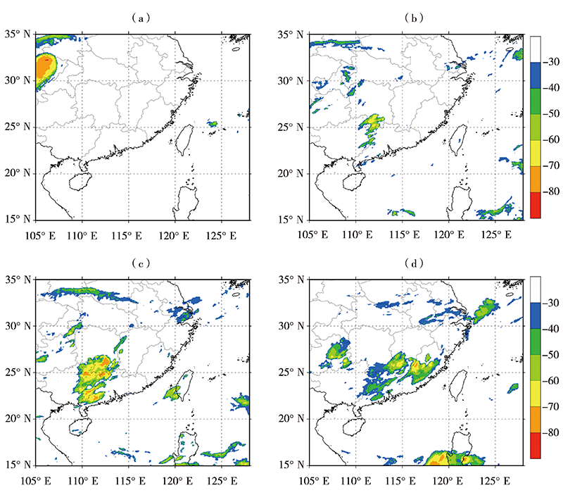
图3 2018年9月6日07:30(a)、12:30(b)、15:30(c)和22:30(d)TBB(单位:℃)
Fig.3 The TBB at 07:30 BST (a), 12:30 BST (b), 15:30 BST (c) and 22:30 BST (d) on September 6, 2018 (Unit: ℃)
图3 2018年9月6日07:30(a)、12:30(b)、15:30(c)和22:30(d)TBB(单位:℃)
Fig.3 The TBB at 07:30 BST (a), 12:30 BST (b), 15:30 BST (c) and 22:30 BST (d) on September 6, 2018 (Unit: ℃)
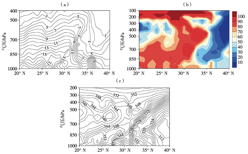
图4 2018年9月6日08:00沿三十六湾站(112.55°E, 25.27°N)的比湿(a,单位:g∙kg-1)、相对湿度(b,单位:%)和假相当位温(c,单位:K)经向垂直剖面
Fig.4 The meridional vertical section of specific humidity (a, Unit: g∙kg-1), relative humidity (b, Unit: %) and pseudo-equivalent potential temperature (c, Unit: K) along Sanshiliuwan station (112.55°E, 25.27°N) at 08:00 BST on September 6, 2018
表2 2018年9月6日08:00和20:00郴州、怀化、长沙探空站对流物理量参数统计
Tab. 2 The statistics of convective physical parameters at Chenzhou, Huaihua and Changsha radiosonde stations at 08:00 BST and 20:00 BST on September 6, 2018
| 站点 | 时间 | CAPE /(J·kg-1) | CIN /(J·kg-1) | K /℃ | SI | IC | Tc/℃ | LCL/hPa | LFC/hPa |
|---|---|---|---|---|---|---|---|---|---|
| 怀化 | 08:00 | 1139.4 | 27.2 | 38 | -1.1 | -23.8 | 27.6 | 962.8 | 860.8 |
| 20:00 | 195.6 | 119.5 | 40 | -1.4 | -21.4 | 27.9 | 921.6 | 701.6 | |
| 长沙 | 08:00 | 0.0 | — | 41 | -2.4 | -18.2 | 36.6 | 964.3 | — |
| 20:00 | 0.0 | — | 40 | -1.1 | -11.8 | 35.2 | 951.2 | — | |
| 郴州 | 08:00 | 610.0 | 89.8 | 40 | -1.5 | -10.7 | 31.8 | 909.4 | 763.4 |
| 20:00 | 1027.5 | 18.8 | 39 | -2.1 | -10.7 | 28.5 | 937.2 | 857.2 |
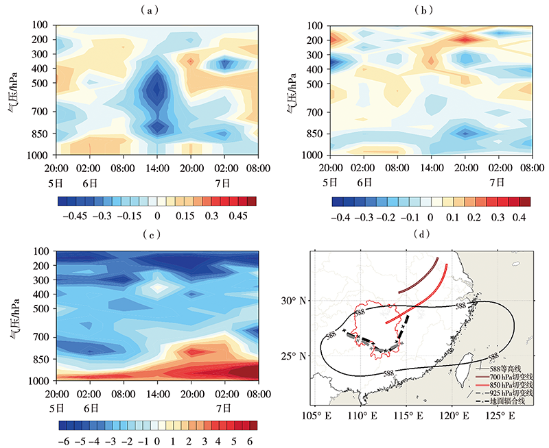
图5 2018年9月5—7日三十六湾站(112.55°E,25.27°N)垂直速度(a,单位:Pa∙ s-1)、散度(b,单位:10-4 s-1)和涡度(c,单位:10-5 s-1)的时间-高度剖面以及6日14:00天气形势示意图(d)
Fig.5 The time-height section of vertical velocity (a, Unit: Pa∙s-1), divergence (b, Unit: 10-4 s-1) and vorticity (c, Unit: 10-5 s-1) at Sanshiliuwan station (112.55°E, 25.27°N) from 5 to 7 September and sketch map of weather situation at 14:00 BST on September 6 (d), 2018
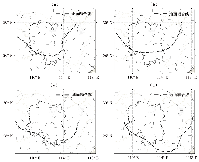
图6 2018年9月6日08:00(a)、11:00(b)、14:00(c)、17:00(d)地面风场(单位:m·s-1)
Fig.6 The surface wind field at 08:00 BST (a), 11:00 BST (b), 14:00 BST (c) and 17:00 BST (d)on September 6, 2018 (Unit: m·s-1)
图6 2018年9月6日08:00(a)、11:00(b)、14:00(c)、17:00(d)地面风场(单位:m·s-1)
Fig.6 The surface wind field at 08:00 BST (a), 11:00 BST (b), 14:00 BST (c) and 17:00 BST (d)on September 6, 2018 (Unit: m·s-1)
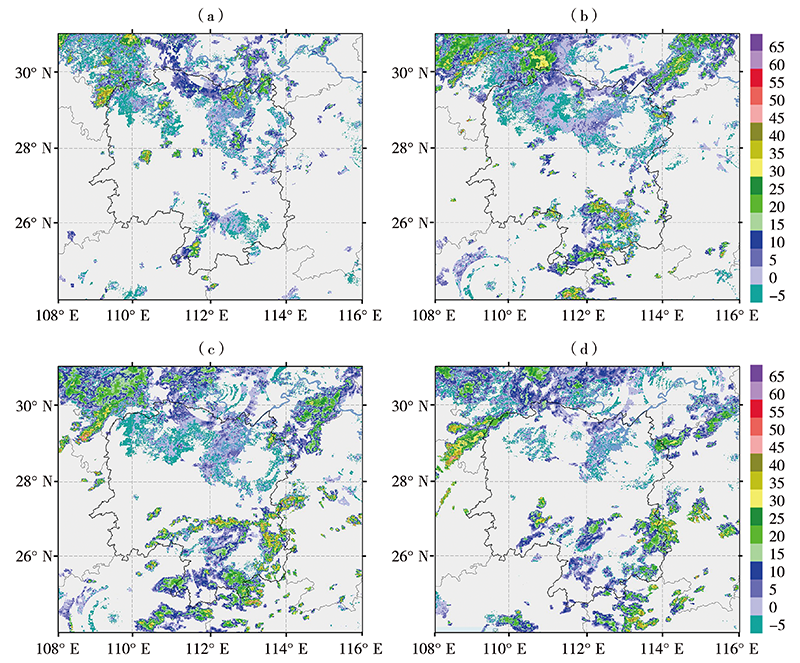
图7 2018年9月6日08:00(a)、13:00(b)、16:00(c)、18:00(d)湖南省及周边地区3 km高度多普勒天气雷达回波拼图(单位:dBZ)
Fig.7 The mosaic map of Doppler radar echo at 3 km height in Hunan Province and its surroundings at 08:00 BST (a), 13:00 BST (b), 16:00 BST (c) and 18:00 BST (d) on September 6, 2018 (Unit: dBZ)
图7 2018年9月6日08:00(a)、13:00(b)、16:00(c)、18:00(d)湖南省及周边地区3 km高度多普勒天气雷达回波拼图(单位:dBZ)
Fig.7 The mosaic map of Doppler radar echo at 3 km height in Hunan Province and its surroundings at 08:00 BST (a), 13:00 BST (b), 16:00 BST (c) and 18:00 BST (d) on September 6, 2018 (Unit: dBZ)
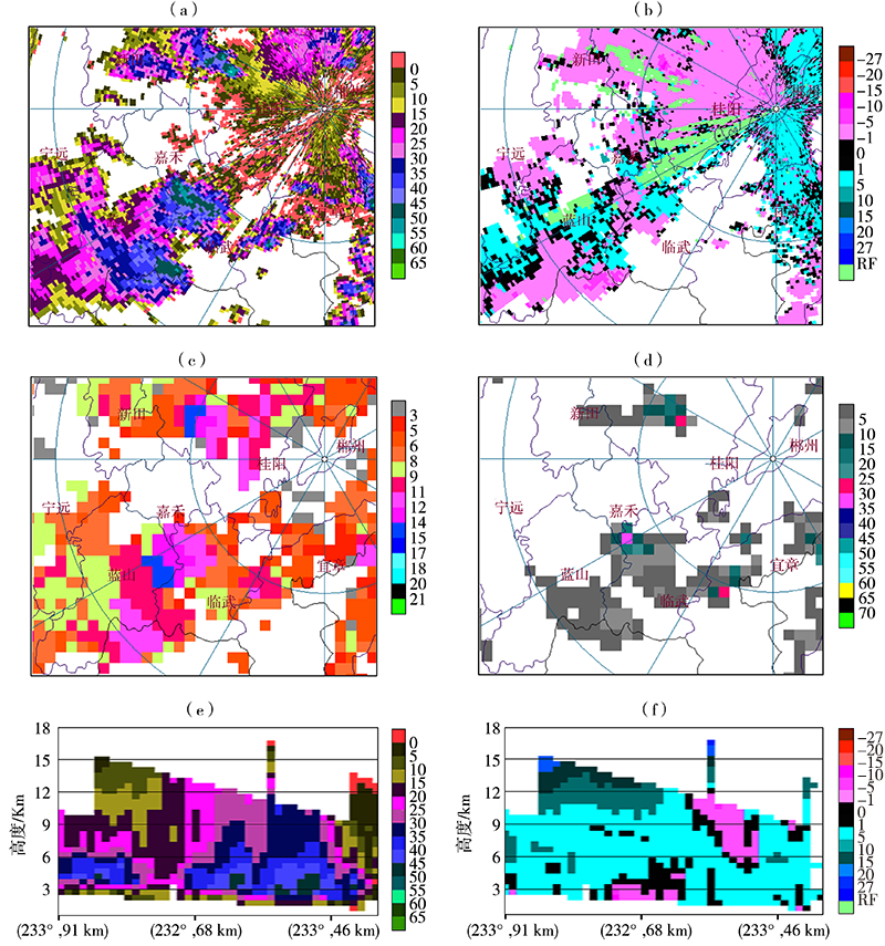
图8 2018年9月6日13:16郴州站雷达2.4°仰角基本反射率(a,单位:dBZ)、1.5°仰角径向速度(b,单位:m∙s-1)、回波顶高(c,单位:km)、垂直积分液态水含量(d,单位:kg∙m-2)及反射率(e, 单位:dBZ)和径向速度(f , 单位:m∙s-1)垂直剖面
Fig.8 The base reflectivity on 2.4° elevation angle (a, Unit: dBZ), radial velocity on 1.5° elevation angle (b, Unit: m∙s-1), echo top height (c, Unit: km), vertical integral liquid water content (d, Unit: kg∙m-2) and vertical section of reflectivity (e, Unit: dBZ) and radial velocity (f, Unit: m∙s-1) at Chenzhou radar station at 13:16 BST on September 6, 2018
| [1] | 高守亭, 周玉淑, 冉令坤. 我国暴雨形成机理及预报方法研究进展[J]. 大气科学, 2018, 42(4): 833-846. |
| [2] | 丁一汇. 陶诗言先生在中国暴雨发生条件和机制研究中的贡献[J]. 大气科学, 2014, 38(4): 616-626. |
| [3] | 许霖, 姚蓉, 李巧媛, 等. 湖南盛夏两次连续性暴雨过程对比分析[J]. 气象与环境学报, 2015, 31(3):15-22. |
| [4] | 叶成志, 潘志祥, 刘志雄, 等. "03.7"湘西北特大致洪暴雨的触发机制数值研究[J]. 应用气象学报, 2007, 18(4): 468-478. |
| [5] | 兰明才, 胡晓琳, 刘红武, 等. 湖南近55年极端降水指数时空分布特征的季节性差异分析[J]. 江西农业学报, 2017, 29(11):102-110. |
| [6] | 周莉, 胡瑞卿, 李伟, 等. 湖南省夏季极端降水异常时空特征及其成因分析[J]. 气象科学, 2018, 38(6):838-848. |
| [7] | REN X J, YANG X Q, SUN X G. Zonal oscillation of western Pacific subtropical high and subseasonal SST variations during Yangtze persistent heavy rainfall events[J]. Journal of Climate, 2013, 26(22):8929-8946. |
| [8] | 刘红武, 邓朝平, 李国平, 等. 东移影响湖南的西南低涡统计分析[J]. 气象与环境科学, 2016, 39(1):59-65. |
| [9] | CHEN X C, ZHAO K, XUE M. Spatial and temporal characteristics of warm season convection over Pearl River Delta region, China, based on 3 years of operational radar data[J]. Journal of Geophysical Research: Atmospheres, 2014, 119(22):12447-12 465. |
| [10] | CHERCHI A, AMBRIZZI T, BEHERA S, et al. The response of subtropical highs to climate change[J]. Current Climate Change Reports, 2018, 4(4): 371-382. |
| [11] | ZHOU T J, YU R C. Atmospheric water vapor transport associated with typical anomalous summer rainfall patterns in China[J]. Journal of Geophysical Research: Atmospheres, 2005, 110, D08104. DOI:10.1029/2004JD005413. |
| [12] | HOSKINS B J. On the existence and strength of the summer subtropical anticyclones: Bernhard Haurwitz memorial lecture[J]. Bulletin of the American Meteorological Society, 1996, 77(6): 1287-1292. |
| [13] | DU Y, YANG L, XIE S P. Tropical Indian Ocean influence on northwest Pacific tropical cyclones in summer following strong El Nino[J]. Journal of Climate, 2011, 24(1):315-322. |
| [14] | KOSAKA Y, CHOWDARY J S, XIE S P, et al. Limitations of seasonal predictability for summer climate over East Asia and the northwestern Pacific[J]. Journal of Climate, 2012, 25(21):7574-7589. |
| [15] | WANG B, XIANG B Q, LEE J Y. Subtropical high predictability establishes a promising way for monsoon and tropical storm predictions[J]. Proceedings of the National Academy of Sciences of the United States of America, 2013, 110(8):2718-2722. |
| [16] | 何立富, 陈涛, 孔期. 华南暖区暴雨研究进展[J]. 应用气象学报, 2016, 27(5):559-569. |
| [17] | 陈贝, 高文良. 川西南地区大暴雨气候特征分析[J]. 高原山地气象研究, 2014, 34(2):39-43. |
| [18] | 陈翔翔, 丁治英, 刘彩虹, 等. 2000—2009年5、6月华南暖区暴雨形成系统统计分析[J]. 热带气象学报, 2012, 28(5):707-718. |
| [19] | 夏茹娣, 赵思雄, 孙建华. 一类华南锋前暖区暴雨β中尺度系统环境特征的分析研究[J]. 大气科学, 2006, 30(5):988-1008. |
| [20] | 张晓美, 蒙伟光, 张艳霞, 等. 华南暖区暴雨中尺度对流系统的分析[J]. 热带气象学报, 2009, 25(5):551-560. |
| [21] | 叶朗明, 徐碧裕. 两次不同类型暖区暴雨的对比分析[J]. 气象研究与应用, 2014, 35(4):5-10, 52. |
| [22] | 刘屹岷, 吴国雄. 副热带高压研究回顾及对几个基本问题的再认识[J]. 气象学报, 2000, 58(4): 500-512. |
| [23] | 刘屹岷, 吴国雄, 刘辉, 等. 空间非均匀加热对副热带高压形成和变异的影响Ⅲ:凝结潜热加热与南亚高压及西太平洋副高[J]. 气象学报, 1999, 57(5):525-538. |
| [24] | 夏文梅, 马中元, 慕瑞琪, 等. 江西副高边缘雷暴大风雷达拼图回波特征分析[J]. 大气科学学报, 2021, 44(5):717-726. |
| [25] | 钱琦雯, 梁萍, 祁莉. 西太平洋副热带高压的季节内活动与变异研究进展[J]. 气象与环境科学, 2021, 44(6):93-101. |
| [26] | 张树民, 缪燕, 周金磊, 等. 副热带高压脊线附近江苏两次强对流天气对比分析[J]. 暴雨灾害, 2017, 36(5):422-430. |
| [27] | 尹红萍, 曹晓岗. 盛夏上海地区副热带高压型强对流特点分析[J]. 气象, 2010, 36(8): 19-25. |
| [28] | 刘红武, 胡燕, 张海, 等. 2020年"6.9"湖南致灾暴雨预报偏差及成因分析[J]. 灾害学, 2022, 37(2):117-124. |
| [29] | 蔡荣辉, 陈静静, 文萍, 等. 2017年湖南一次特大致洪暴雨过程的水汽特征[J]. 干旱气象, 2019, 37(2):288-300. |
| [1] | 许敏, 沈芳, 刘淇淇, 李娜, 王洁. 线状MCSs强降水特征及形成条件[J]. 干旱气象, 2022, 40(4): 596-604. |
| [2] | 钟敏, 肖安, 许冠宇. 基于CMA-MESO的分级短时强降水概率预报方法研究[J]. 干旱气象, 2022, 40(4): 700-709. |
| [3] | 李蓉, 刘新伟, 魏栋, 段海霞, 段伯隆, 李嘉睿, 狄潇泓. 基于区域自动站数据的兰州地区降水精细化特征[J]. 干旱气象, 2022, 40(1): 55-61. |
| [4] | 杨振鑫, 祁萍, 孙磊, 崔小平, 赵月兰. 青藏高原东北侧短时强降水阈值确定及特征分析[J]. 干旱气象, 2021, 39(4): 563-568. |
| [5] | 杨涛, 杨莲梅, 张云惠, 庄晓翠, 黄艳. 新疆短时强降水天气系统环流配置及雷达回波特征[J]. 干旱气象, 2021, 39(4): 631-640. |
| [6] | 肖玮, 傅朝, 徐丽丽, 刘维成, 狄潇泓, 郑新, 杨秀梅. 陇东南汛前期2次斜压锋生类短时强降水过程动力特征对比[J]. 干旱气象, 2021, 39(4): 641-651. |
| [7] | 师锐, 何光碧, 周春花. 四川一次持续性暴雨过程的水汽特征及多尺度系统影响分析[J]. 干旱气象, 2021, 39(3): 415-425. |
| [8] | 张武龙, 康岚, 周威, 银航, . 基于GRAPES-MESO模式的极端短时强降水预报[J]. 干旱气象, 2021, 39(3): 507-513. |
| [9] | 王孝慈, 李双君, 孟英杰. 2016—2020年6—7月长江流域主要暴雨过程特征及差异性分析[J]. 干旱气象, 2021, 39(06): 921-929. |
| [10] | 苏军锋, 张锋, 黄玉霞, 刘丽, 张秋瑜, 魏清霞, 张燕. 甘肃陇南市短时强降水时空分布特征及中尺度分析[J]. 干旱气象, 2021, 39(06): 966-973. |
| [11] | 马浩, 刘昌杰, 钱奇峰, 徐哲永, 肖晶晶, 杨明, 高大伟. 2018年5月浙江省极端高温气候特征及环流背景[J]. 干旱气象, 2020, 38(6): 909-919. |
| [12] | 张宁, 刘科男, 王遂缠, 王骥, 陈自艳. 兰州市短时强降水的时空分布特征及地形因素[J]. 干旱气象, 2020, 38(2): 242-248. |
| [13] | 程鹏, 罗汉, 陈佩璇, 曹彦超, 李宝梓, 陈祺. 庆阳黄土高原短时强降水统计特征及预警指标[J]. 干旱气象, 2020, 38(2): 319-328. |
| [14] | 张芹, 苏莉莉, 张秀珍, 袁静, 周树华, 王善芳. 山东一次暖区暴雨的环境场特征和触发机制[J]. 干旱气象, 2019, 37(6): 933-943. |
| [15] | 李媛, 李瑞芬, 张熙. 不同分布型El Niño事件对山东次年夏季降水的影响#br#[J]. 干旱气象, 2019, 37(5): 762-770. |
| 阅读次数 | ||||||
|
全文 |
|
|||||
|
摘要 |
|
|||||
