Journal of Arid Meteorology ›› 2025, Vol. 43 ›› Issue (4): 576-585.DOI: 10.11755/j.issn.1006-7639-2025-04-0576

• Articles • Previous Articles     Next Articles

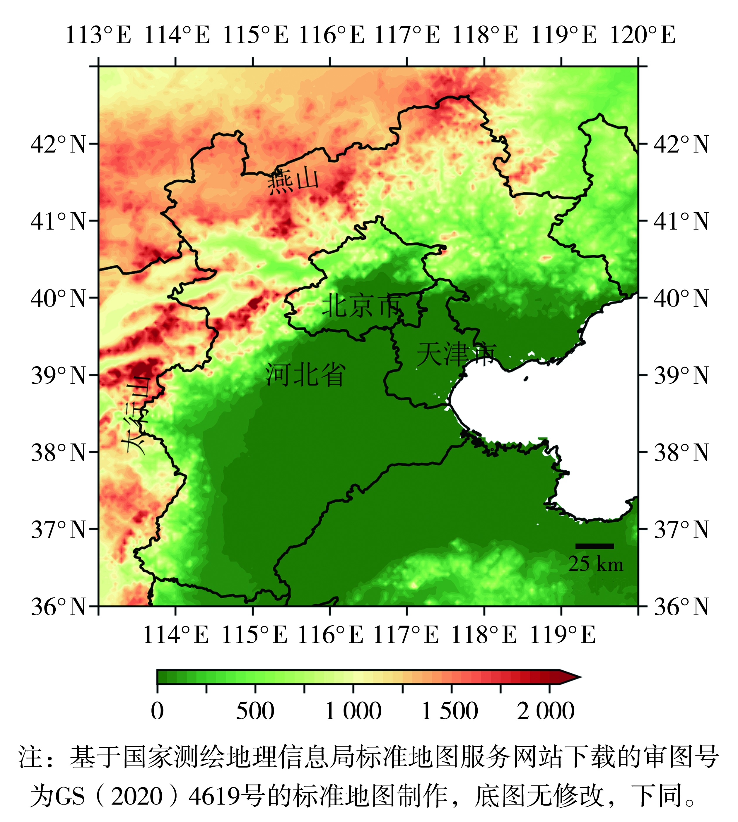
Summer precipitation characteristics under the influence of complex terrain in the Beijing-Tianjin-Hebei region and its numerical simulation evaluation

LI Jing1(), LI Ziming1,2(), HAO Cui1, DAI Yi1, XING Nan1   

  1. 1. Beijing Meteorological Observatory, Beijing 100097, China
    2. Beijing Yanyun Meteorological Technology Co., Ltd, Beijing 100097, China
  • Received:2024-05-20 Revised:2025-05-21 Online:2025-08-31 Published:2025-09-08

复杂地形下京津冀地区夏季降水特征及其数值模拟评估

李靖1(), 李梓铭1,2(), 郝翠1, 戴翼1, 邢楠1   

  1. 1.北京市气象台,北京 100097
    2.北京燕云气象科技有限责任公司,北京 100097
  • 通讯作者: 李梓铭
  • 作者简介:李靖(1981—),女,高级工程师,主要从事天气预报检验评估相关工作。E-mail: bjlj_02@163.com
  • 基金资助:
    中国气象局创新发展专项(CXFZ2024J017)

Abstract:

Based on the hourly precipitation analysis data of the China Meteorological Administration multi-source merged precipitation analysis system (CMPAS) and the hourly precipitation data predicted by the China Meteorological Administration mesoscale weather forecast system (CMA-MESO), the distribution characteristics of precipitation in the Beijing-Tianjin-Hebei region under special topographic conditions from June to September 2021 were analyzed, and the prediction performance of CMA-MESO was discussed. The results are as follows: (1) The observational maximum centers of mean hourly precipitation in the Beijing-Tianjin-Hebei region were primarily located in 100-600 m altitude on the windward slopes of the eastern Taihang Mountains and the southern foothills of the Yanshan Mountains, while the maximum centers predicted by the CMA-MESO were located on the side of the windward slope leaning towards the plain in front of the mountains. The observational hourly precipitation frequency and intensity were similar to precipitation amount, but the maximum center of hourly precipitation frequency was located on the windward slopes of the Taihang Mountains, leaning towards the mountainous side, while the maximum center of precipitation intensity was mainly distributed on the windward slopes in front of the mountains and the plain areas of the eastern Beijing-Tianjin-Hebei region. (2) The observational regional average hourly precipitation amount on the windward slopes in front of mountains of the Beijing-Tianjin-Hebei region exhibited a bimodal diurnal pattern, with the primary peak occurring from afternoon to evening and the secondary peak in the early morning. The primary peak predicted by the CMA-MESO was colse to observations, but the regional average hourly precipitation amount was significantly overestimated. (3) On the windward slopes in front of the mountains, the peak period of precipitation above 10 mm·h-1 occurred from the afternoon to the early morning and the early hours of the next day. The CMA-MESO forecast indicated that the precipitation above 10 mm·h-1 in the afternoon to evening period was slightly higher, while the precipitation in the early hours of the next day was slightly lower. (4) Precipitation events on the windward slopes from afternoon to early nighttime were mainly short-term precipitation events within 3 hours. The CMA-MESO taked the characteristic, but the amount of short-term precipitation events predicted by it was relatively high. (5) The CMA-MESO successfully forecasted the topographic enhancement of precipitation on the windward side of the mountains. However, the specific humidity below 850 hPa was underestimated, and the convective available potential energy value at 14:00 (Beijing Time) was significantly underestimated. These biases contributed to the existence of a negative precipitation bias center over the windward slopes.

Key words: CMA-MESO, the Beijing-Tianjin-Hebei region, evaluation of precipitation forecasting, average hourly precipitation amount, hourly precipitation frequency, precipitation intensity

摘要:

基于三源融合降水产品(China Meteorological Administration Multi-source Merged Precipitation Analysis System,CMPAS)和中尺度数值预报系统(China Meteorological Administration Mesoscale Weather Forecast System,CMA-MESO)预报的逐小时降水数据,分析2021年6—9月京津冀特殊地形下降水的分布特征,进一步评估CMA-MESO的预报性能。 结果表明:(1)京津冀地区实况平均小时降水量大值中心主要位于太行山东部和燕山南麓山前迎风坡海拔100~600 m处,CMA-MESO预报的大值区位于山前迎风坡偏向平原一侧;实况小时降水频率大值中心在太行山山前迎风坡偏向山区一侧,降水强度大值中心分布在山前迎风坡和东部平原地区。(2)京津冀山前迎风坡地区实况平均小时降水量随时间呈现双峰型特征,主峰值出现在午后至前半夜,次峰值出现在凌晨;CMA-MESO预报的主峰值时间与实况接近,但平均小时降水量明显偏大。(3)京津冀山前迎风坡地区实况10 mm·h-1以上降水量占比大值时段在午后至前半夜和凌晨;CMA-MESO预报的午后至傍晚时段10 mm·h-1以上降水量偏大,凌晨时段降水量偏小。(4)山前迎风坡地区午后至前半夜降水事件以3 h内的短时降水为主,CMA-MESO较好地把握了这一特征,但预报的短历时降水事件偏多。(5)CMA-MESO预报出了山前迎风坡一侧地形对降水的增幅作用,和山地上空的次级环流,但850 hPa以下比湿预报偏小,14:00(北京时)对流有效位能值明显偏小,也是山前迎风坡降水量存在负偏差中心的原因。

关键词: CMA-MESO, 京津冀地区, 降水预报评估, 平均小时降水量, 小时降水频率, 降水强度

CLC Number: