干旱气象 ›› 2026, Vol. 44 ›› Issue (4): 703-713.DOI: 10.11755/j.issn.1006-7639-2026-04-0703

• 论文 • 上一篇    

河北省边界层通风量时空特征及对PM2.5污染的影响

赵娜1,2,3(), 焦亚音3, 杨雨灵3, 赵玉广1,2,3(), 卢西畅4,5   

  1. 1 中国气象局太行山—燕山暴雨野外科学试验基地河北 邢台 054000
    2 河北省气象与现代经济重点实验室河北 石家庄 050021
    3 河北省气象灾害防御和环境气象中心河北 石家庄 050021
    4 河北饶阳国家气候观象台河北 饶阳 053900
    5 河北衡水市气象局河北 衡水 053000
  • 收稿日期:2025-09-11 修回日期:2026-02-08 出版日期:2026-08-30 发布日期:2026-09-16
  • 通讯作者: 赵玉广(1969—),男,河北辛集人,正高级工程师,主要从事环境气象预报技术研究。E-mail: zyg_9@163.com
  • 作者简介:赵娜(1983—),女,河北吴桥人,高级工程师,主要从事颗粒物和臭氧污染气象条件监测预报及模拟评估、重污染预报预警技术研究。E-mail: zhaona2307@126.com
  • 基金资助:
    河北省自然科学基金项目(D2024304014);中国气象局创新发展专项(CXFZ2026J138)

Spatiotemporal characteristics of boundary layer ventilation in Hebei Province and its impact on PM2.5 pollution

ZHAO Na1,2,3(), JIAO Yayin3, YANG Yuling3, ZHAO Yuguang1,2,3(), LU Xichang4,5   

  1. 1 Taihang-Yanshan Mountains Field Research Station for Heavy RainfallCMA, Xingtai 054000Hebei, China
    2 Hebei Key Laboratory of Meteorology and Modern EconomyShijiazhuang 050021, China
    3 Hebei Meteorological Disaster Prevention and Environment Meteorology CenterShijiazhuang 050021, China
    4 Raoyang National Climate Observatory of Hebei ProvinceRaoyang 053900Hebei, China
    5 Hengshui Meteorological Bureau of Hebei ProvinceHengshui 053000Hebei, China
  • Received:2025-09-11 Revised:2026-02-08 Online:2026-08-30 Published:2026-09-16

摘要:

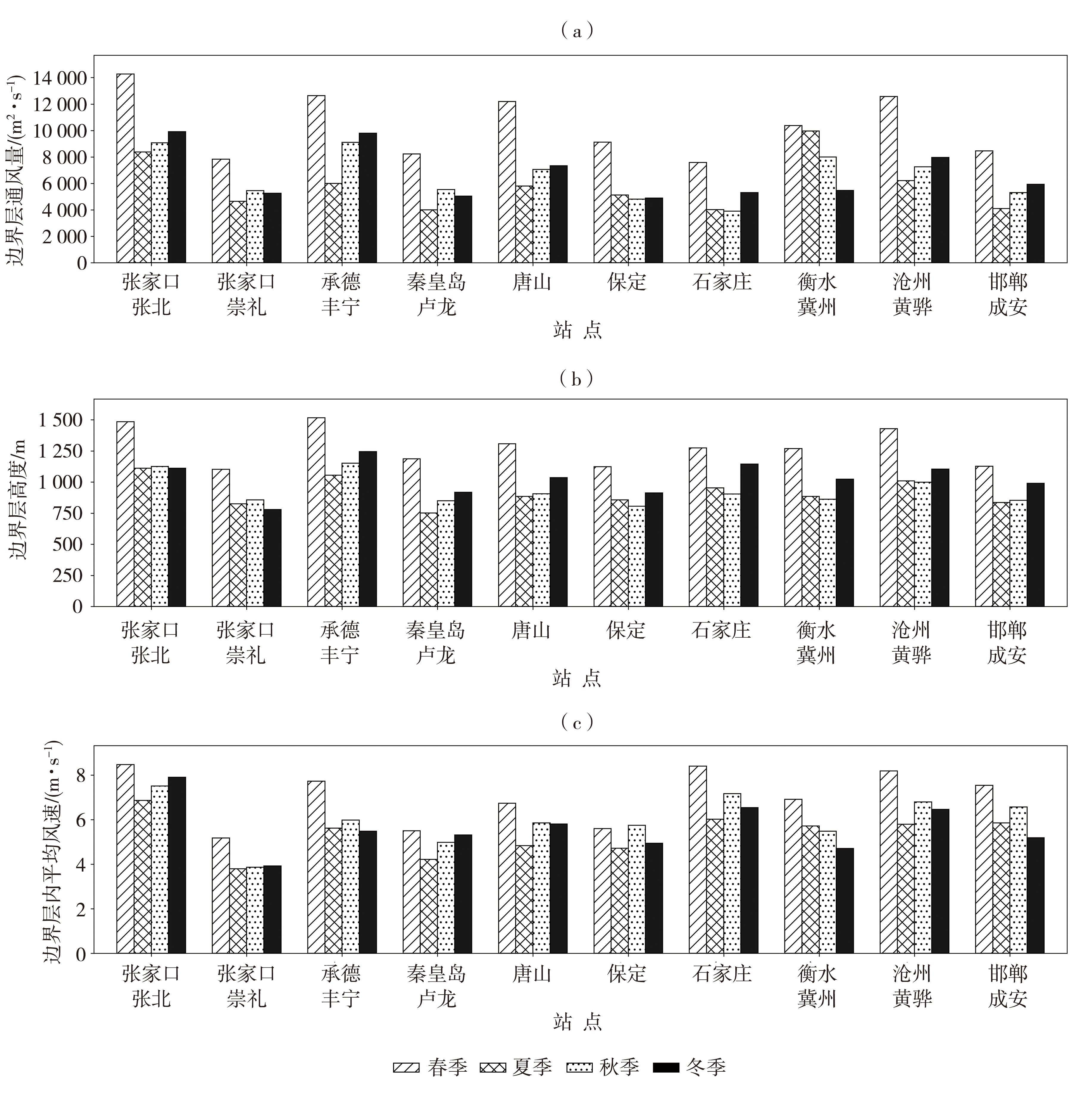
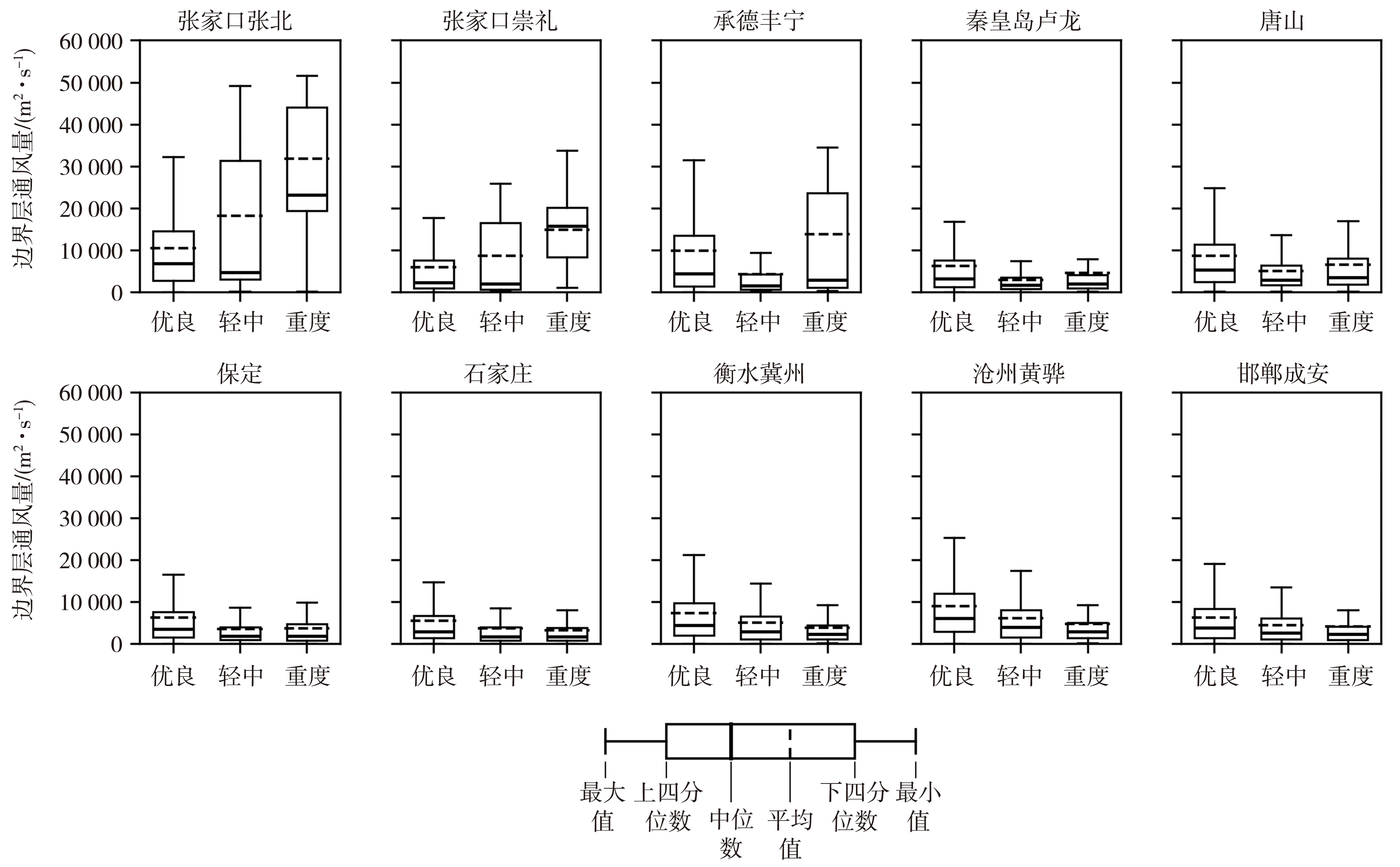
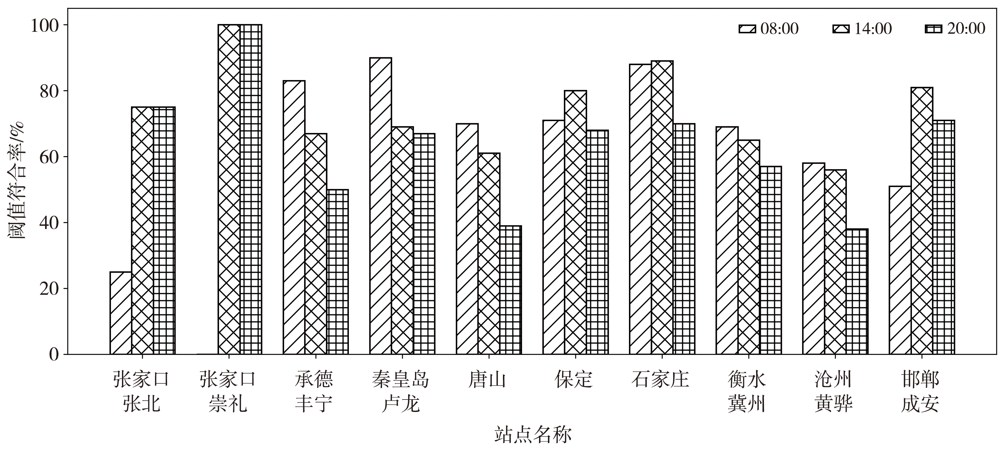
边界层通风量能够表征边界层内水平输送对污染物的扩散能力,是影响近地面污染物累积、传输与消散的重要因素。基于2021—2022年河北省10个站点风廓线雷达、地面气象和环境监测资料,系统分析边界层通风量的时空变化特征和主要影响因子及其与细颗粒物(PM2.5)污染的关系。结果表明,河北省边界层通风量空间上总体呈“北高南低”分布特征,张家口—承德(简称张承)地区较高,太行山东麓和燕山南麓地区较低;时间上表现为春季最强、夏季最弱,日变化呈午后单峰型特征,且多数站点边界层通风量变化与边界层内平均风速具有较好一致性。张承地区春季PM2.5质量浓度升高可能与大风沙尘过程有关。秋冬季,边界层通风量与PM2.5质量浓度超标存在较好的对应关系,确定08:00、14:00和20:00边界层通风量监测阈值分别为2 000、8 000和3 000 m2·s-1。利用2023—2024年独立资料验证表明,08:00和14:00边界层通风量阈值的平均符合率超过70%,表明所建立的阈值对秋冬季PM2.5污染过程具有较好的指示能力。

关键词: 风廓线雷达, 边界层通风量, 时空分布, PM2.5污染

Abstract:

Boundary layer ventilation (VI) can characterize the capacity of horizontal transport within the boundary layer to disperse pollutants, and is an important factor affecting the accumulation, transport, and dissipation of near-surface pollutants. Based on wind profiler radar, surface meteorological, and environmental monitoring data from 10 stations in Hebei Province during 2021-2022, the spatiotemporal variation characteristics and major influencing factors of VI and its relationship with fine particulate matter (PM2.5) pollution are systematically analyzed. The results show that VI in Hebei Province generally exhibits a spatial pattern of “higher in the north and lower in the south”, with higher values in the Zhangjiakou-Chengde region and lower values in the areas along the eastern foothills of the Taihang Mountains and the southern foothills of the Yanshan Mountains. Temporally, VI is strongest in spring and weakest in summer, and exhibits a unimodal diurnal variation pattern with a peak in the afternoon. VI variations at most stations are generally consistent with the mean wind speed within the boundary layer. The increase in PM2.5 mass concentrations in the Zhangjiakou-Chengde region during spring may be associated with strong winds and dust events. During autumn and winter, VI shows a good correspondence with PM2.5 mass concentration exceedances, and the VI monitoring thresholds are determined as 2 000, 8 000, and 3 000 m2·s-1 at 08:00, 14:00, and 20:00, respectively. Validation using independent data from 2023-2024 shows that the mean agreement rates of the thresholds at 08:00 and 14:00 exceed 70%, indicating that the established thresholds have good indicative capability for PM2.5 pollution events during autumn and winter.

Key words: wind profiler radar, boundary layer ventilation, spatiotemporal distribution, PM2.5 pollution

中图分类号: