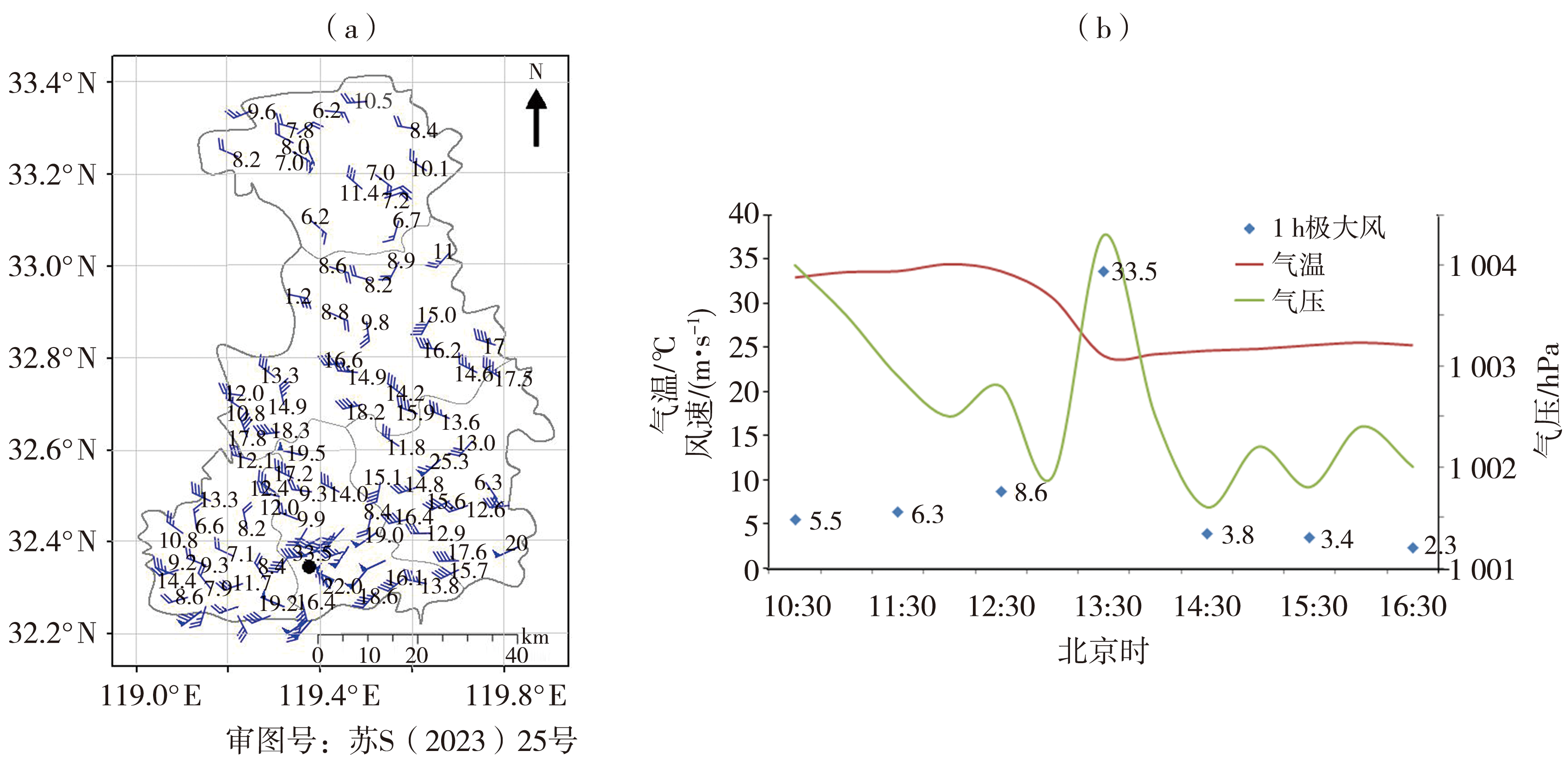
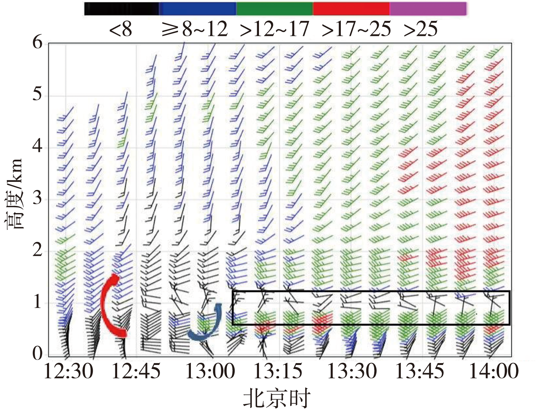
| [1] |
陈明轩, 王迎春, 2012. 低层垂直风切变和冷池相互作用影响华北地区一次飑线过程发展维持的数值模拟[J]. 气象学报, 70(3): 371-386.
|
| [2] |
陈圣劼, 刘梅, 杨梦兮, 等, 2022. 江苏“4·30”强风雹成因及双偏振雷达特征分析[J]. 气象科学, 42(5): 638-649.
|
| [3] |
丁一汇, 李鸿洲, 章名立, 等, 1982. 我国飑线发生条件的研究[J]. 大气科学, 6(1): 18-27.
|
| [4] |
段亚鹏, 王东海, 刘英, 2017. “东方之星”翻沉事件强对流天气分析及数值模拟[J]. 应用气象学报, 28(6): 666-677.
|
| [5] |
金子琪, 王新敏, 鲍艳松, 等, 2021. 基于卷积神经网络的飑线识别算法[J]. 应用气象学报, 32(5): 580-591.
|
| [6] |
梁俊平, 张一平, 2015. 2013年8月河南三次西南气流型强对流天气分析[J]. 气象, 41(11): 1 328-1 340.
|
| [7] |
马淑萍, 王秀明, 俞小鼎, 2019. 极端雷暴大风的环境参量特征[J]. 应用气象学报, 30(3): 292-301.
|
| [8] |
马中元, 苏俐敏, 谌芸, 等, 2014. 一次强飑线及飑前中小尺度系统特征分析[J]. 气象, 40(8): 916-929.
|
| [9] |
孙继松, 戴建华, 何立富, 等, 2014. 强对流天气预报的基本原理与技术方法:中国强对流天气预报手册[M]. 北京: 气象出版社.
|
| [10] |
王啸华, 郑媛媛, 濮梅娟, 等, 2018. 强天气综合报警追踪平台功能设计及龙卷预警中的应用[J]. 气象科技进展, 8(3): 61-69.
|
| [11] |
王秀明, 俞小鼎, 周小刚, 等, 2012. “6.3”区域致灾雷暴大风形成及维持原因分析[J]. 高原气象, 31(2): 504-514.
|
| [12] |
王易, 郑媛媛, 庄潇然, 等, 2022. 江苏典型下击暴流风暴结构特征统计分析[J]. 气象学报, 80(4): 592-603.
|
| [13] |
韦惠红, 吴翠红, 魏凡, 等, 2023. 湖北雷暴阵风锋特征及其对流触发作用分析[J]. 干旱气象, 41(1): 73-81.
DOI
|
| [14] |
吴海英, 裴海瑛, 沈树勤, 等, 2007. 飑线传播与发展及其引发地面强风过程个例分析[J]. 气象科技, 35(5): 676-680.
|
| [15] |
吴瑞姣, 陶玮, 周昆, 等, 2019. 江淮灾害性大风飑线的特征分析[J]. 气象, 45(2): 155-165.
|
| [16] |
严明良, 卞光辉, 沈树勤, 2006. 江苏沿海气象灾害预报及产业警示技术[J]. 气象科技, 34(6): 735-740.
|
| [17] |
俞小鼎, 王秀明, 李万莉, 等, 2020. 雷暴与强对流临近预报[M]. 北京: 气象出版社.
|
| [18] |
俞小鼎, 周小刚, 王秀明, 2012. 雷暴与强对流临近天气预报技术进展[J]. 气象学报, 70(3): 311-337.
|
| [19] |
张建军, 王咏青, 钟玮, 2016. 飑线组织化过程对环境垂直风切变和水汽的响应[J]. 大气科学, 40(4): 689-702.
|
| [20] |
郑媛媛, 张雪晨, 朱红芳, 等, 2014. 东北冷涡对江淮飑线生成的影响研究[J]. 高原气象, 33(1): 261-269.
DOI
|
| [21] |
周后福, 刁秀广, 赵倩, 等, 2017. 一次连续下击暴流天气的成因分析[J]. 干旱气象, 35(4): 641-648.
DOI
|
| [22] |
竹利, 卢德全, 廖文超, 等, 2021. 连续两次飑线大风成因对比分析[J]. 干旱气象, 39(5): 796-806.
DOI
|
| [23] |
JOHNS R H, HIRT W D, 1987. Derechos: Widespread convectively induced windstorms[J]. Weather and Forecasting, 2(1): 32-49.
|
| [24] |
MENG Z Y, YAN D C, ZHANG Y J, 2013. General features of squall lines in East China[J]. Monthly Weather Review, 141(5): 1 629-1 647.
|
| [25] |
TAKEMI T, 2014. Convection and precipitation under various stability and shear conditions: Squall lines in tropical versus midlatitude environment[J]. Atmospheric Research, 142: 111-123.
|
| [26] |
WILSON J W, MUELLER C K, 1993. Nowcasts of thunderstorm initiation and evolution[J]. Weather and Forecasting, 8(1): 113-131.
|
| [27] |
WILSON J W, SCHREIBER W E, 1986. Initiation of convective storms at radar-observed boundary-layer convergence lines[J]. Monthly Weather Review, 114(12), 2516-2 536.DOI:10.1175/1520-0493(1986)114<2516:IOCSAR>2.0.CO;2.
|
 ), Zhu Huan2, JIANG Qijin3, YIN Jun3, ZHANG Yuan1