干旱气象 ›› 2023, Vol. 41 ›› Issue (5): 753-763.DOI: 10.11755/j.issn.1006-7639(2023)-05-0753

• 论文 • 上一篇    下一篇

贵州一次辐合线锋生极端暴雨过程的中尺度特征分析

吴古会1,2(), 彭芳2,3, 齐大鹏1,2, 杜小玲1,2, 杨秀庄1,2()   

  1. 1.贵州省气象台,贵州 贵阳 550002
    2.贵州山地气候与资源重点实验室,贵州 贵阳 550002
    3.贵州省山地环境气候研究所,贵州 贵阳 550002
  • 收稿日期:2022-04-07 修回日期:2022-11-06 出版日期:2023-10-31 发布日期:2023-11-03
  • 通讯作者: 杨秀庄(1983—),男,贵州遵义人,高级工程师,主要从事天气预报预测及短时临近预报预警技术研究。E-mail: 115196063@qq.com
  • 作者简介:吴古会(1985—),女,贵州兴义人,高级工程师,主要从事天气预报预测及短时临近预报预警技术研究。E-mail:19106289@qq.com
  • 基金资助:
    中国气象局暴雨创新团队项目(CMACXTD002-3);西南区域重大科研业务项目(西南区域2014-3);贵州省山地气候与资源重点实验室基金项目(QHLSSLJ[2022]-12);中国气象局复盘总结专项(FPZJ2023-115)

Analysis on mesoscale feature of a extremely rainstorm process caused by the convergence line frontogenesis in Guizhou Province

WU Guhui1,2(), PENG Fang2,3, QI Dapeng1,2, DU Xiaoling1,2, YANG Xiuzhuang1,2()   

  1. 1. Guizhou Meteorological Observatory, Guiyang 550002, China
    2. Key Laboratory for Mountains Climate and Resources of Guizhou, Guiyang 550002, China
    3. Guizhou Institude of Mountainous Environment and Climate, Guiyang 550002, China
  • Received:2022-04-07 Revised:2022-11-06 Online:2023-10-31 Published:2023-11-03

摘要:

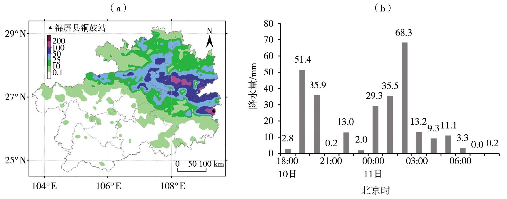
利用地面常规观测资料及加密自动站观测资料、FY-2G卫星云图、多普勒天气雷达产品和ERA5再分析资料,对2021年5月10日贵州东部和北部的一次辐合线锋生极端暴雨过程中尺度特征进行分析,初步探讨其形成机制。结果表明:此次极端暴雨过程发生在低涡切变背景下,低层强盛的南风为中尺度对流系统发生发展输送了充足的水汽和不稳定能量,地面辐合线及锋生提供了触发条件,暴雨区主要位于云团云顶亮温低值中心西侧或南侧梯度大值区,并沿地面辐合线呈东西向带状分布,最强降水发生在对流云团合并阶段。辐合线锋生作用在其西侧频繁触发对流单体,新生对流单体沿地面辐合线东移发展,持续影响贵州东部和北部地区。在降水最强的两个阶段,雷达回波呈现暖云和悬垂结构特征。地面辐合线及其锋生、上游降水带来的降温增压以及持续增强的南风有利于暴雨区水汽辐合增强,而垂直方向上纬向、经向中尺度次级环流上升支正好位于特大暴雨中心附近,有利于中尺度对流系统维持和增强。

关键词: 暴雨过程, 地面辐合线, 锋生, 中尺度特征, 次级环流

Abstract:

Based on ground conventional observation data and intensive observation data from automatic weather stations, cloud images of FY-2G satellite, Doppler radar data and ERA5 reanalysis data, the mesoscale synoptic characteristics of a extremely rainstorm process caused by convergence line frontogenesis in eastern and northern Guizhou on 10 May 2021 were analyzed, and the formation mechanism was preliminary discussed. The results show that the extremely rainstorm process occurred under the background of low vortex shear, and the strong southerly wind at low level transported abundant water vapor and unstable energy for the occurrence and development of the mesoscale convective system, the surface convergence line and its frontogenesis provided triggerring condition for the rainstorm. The rainstorm areas mainly occurred in the large gradient areas of temperature black body (TBB), in which were located on the west or south side of the low value center of cloud cluster TBB, and they appeared a strip-shaped distribution in east-west direction along the surface convergence line. The strongest precipitation occurred at the merging stage of convective cloud cluster. The frontogenesis caused by the convergence line frequently triggered convective cells on the west side of the convergence line, and the new convective cells moved and developed eastward along the surface convergence line, which continuously affected the eastern and northern regions of Guizhou Province. At two stages of the strongest precipitation, the warm cloud and overhang structure characteristics of radar echo were obvious. The surface convergence line and its frontogenesis, the cooling and increasing pressure generated by the upstream precipitation and continuously strengthening southerly wind were conducive to the enhancement of water vapor convergence in rainstorm areas. In the vertical direction, the ascending branches of meridional and zonal mesoscale secondary circulation were located near the extremely rainstorm center, which was conducive to the maintenance and enhancement of mesoscale convective system.

Key words: rainstorm process, surface convergence line, frontogenesis, mesoscale feature, secondary circulation

中图分类号: