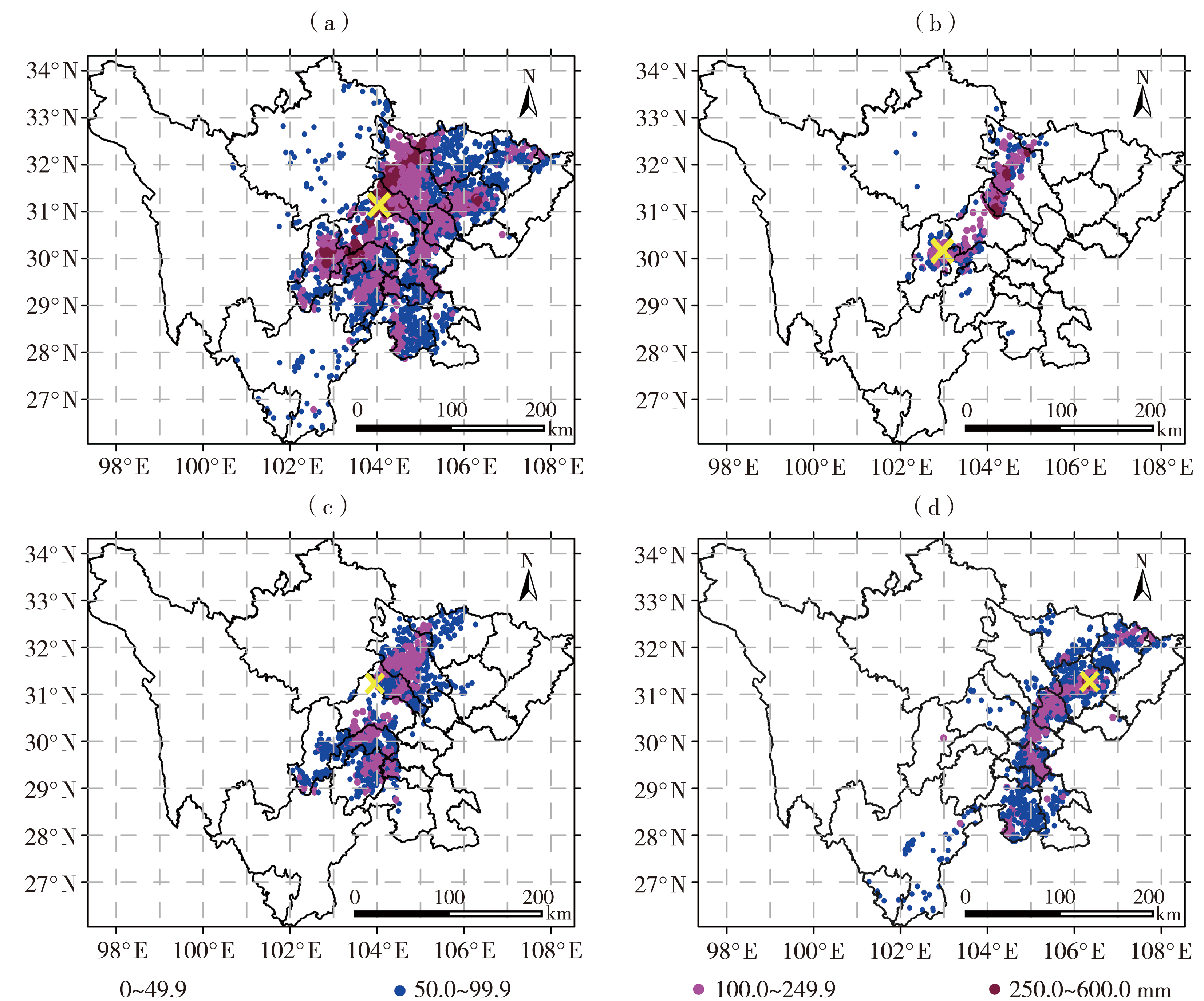
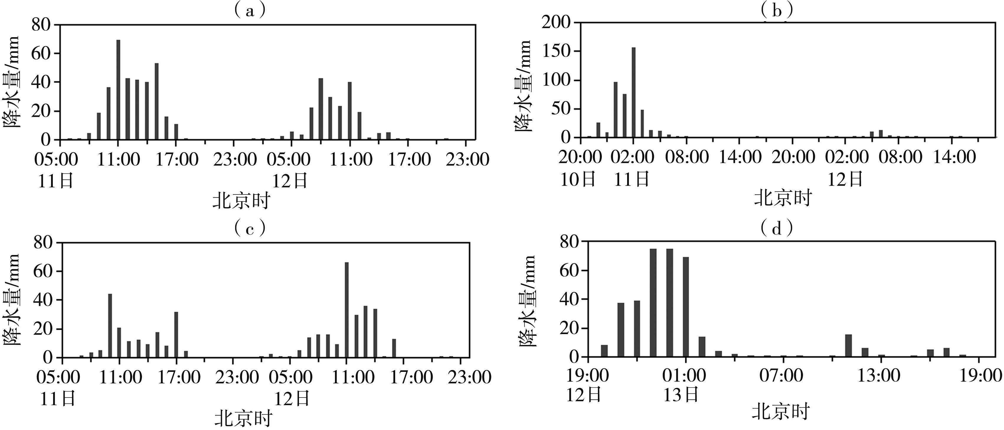
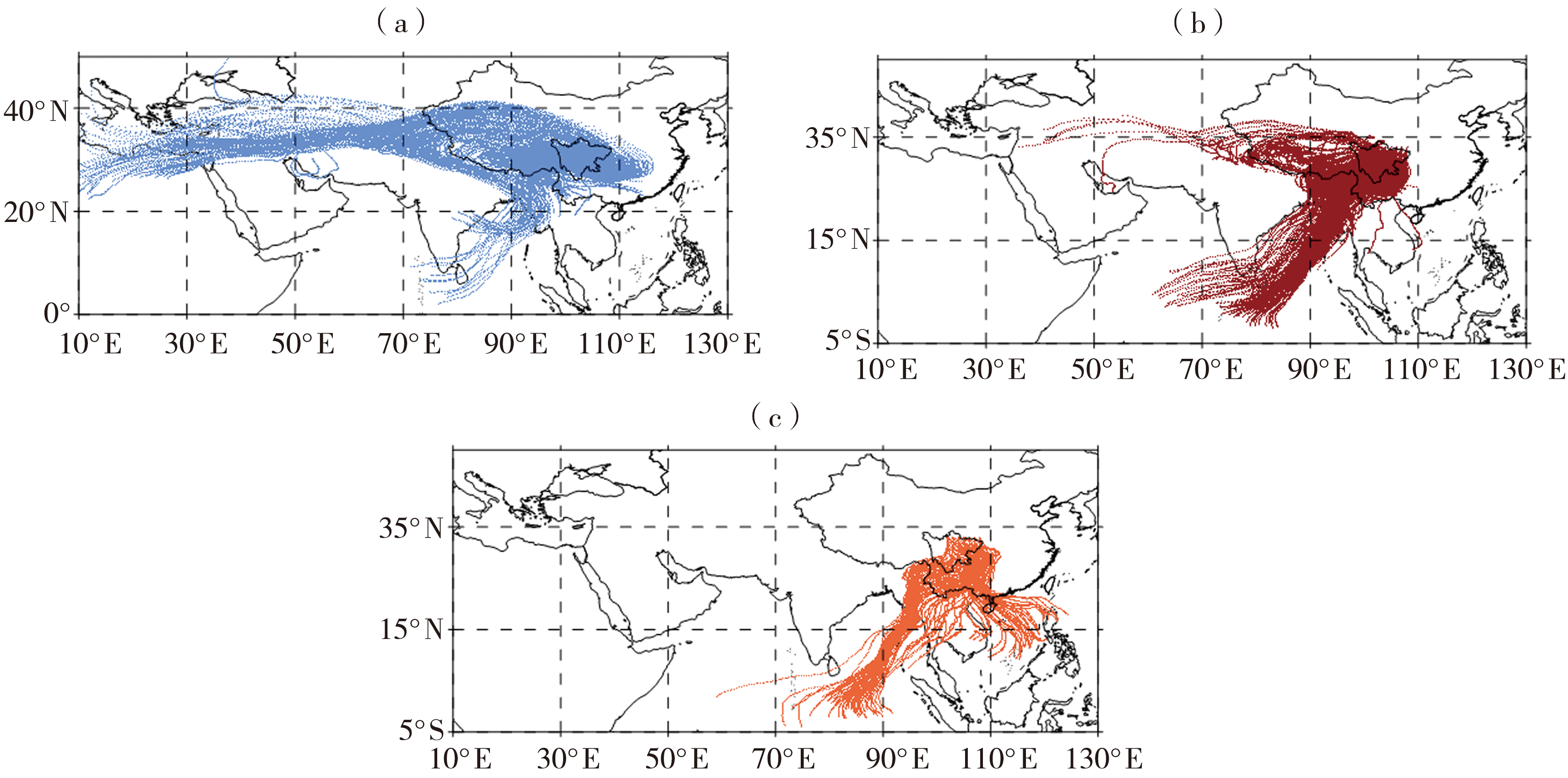
| [1] |
陈栋, 李跃清, 黄荣辉, 2007. 在“鞍”型大尺度环流背景下西南低涡发展的物理过程分析及其对川东暴雨发生的作用[J]. 大气科学, 31(2): 185-201.
|
| [2] |
丛芳, 曹萍萍, 王佳津, 等. 2021. 四川盆地夏季一次特大暴雨水汽特征[J]. 长江流域资源与环境, 30(8): 2 028-2 037.
|
| [3] |
高琦, 姚秀萍, 2021. 2020年长江中下游梅汛期干冷空气演变特征及其作用分析[J]. 暴雨灾害, 40(4): 342-351.
|
| [4] |
江志红, 梁卓然, 刘征宇, 等, 2011. 2007年淮河流域强降水过程的水汽输送特征分析[J]. 大气科学, 35(2): 361-372.
|
| [5] |
李晓容, 高青云, 付世军, 2020. 四川盆地东北部三次持续性暴雨过程水汽输送特征分析[J]. 暴雨灾害, 39(3): 234-240.
|
| [6] |
李永华, 徐海明, 高阳华, 等, 2010. 西南地区东部夏季旱涝的水汽输送特征[J]. 气象学报, 68(6): 932-943.
|
| [7] |
刘芸芸, 丁一汇, 2020. 2020年超强梅雨特征及其成因分析[J]. 气象, 46(11): 1 393-1 404.
|
| [8] |
牛若芸, 金荣花, 2009. 2008年梅雨异常大尺度环流成因分析[J]. 高原气象, 28(6): 1 326-1 334.
|
| [9] |
任伟, 任燕, 李兰兰, 2019. 基于HYSPLIT模式的济南机场一次暴雨过程的水汽输送特征分析[J]. 海洋气象学报, 39(1): 116-122.
|
| [10] |
师锐, 何光碧, 周春花, 2021. 四川一次持续性暴雨过程的水汽特征及多尺度系统影响分析[J]. 干旱气象, 39(3): 415-425.
|
| [11] |
王佳津, 王春学, 陈朝平, 等, 2015. 基于HYSPLIT4的一次四川盆地夏季暴雨水汽路径和源地分析[J]. 气象, 41(11): 1 315-1 327.
|
| [12] |
王佳津, 肖递祥, 王春学, 2017. 四川盆地极端暴雨水汽输送特征分析[J]. 自然资源学报, 32(10): 1 768-1 783.
|
| [13] |
王婧羽, 崔春光, 王晓芳, 等, 2014. 2012年7月21日北京特大暴雨过程的水汽输送特征[J]. 气象, 40(2): 133-145.
|
| [14] |
肖递祥, 屠妮妮, 祁生秀, 2015. 龙门山沿线暴雨过程的诊断分析及数值试验[J]. 高原气象, 34(1): 113-123.
DOI
|
| [15] |
肖递祥, 顾清源, 祁生秀, 2009. 2008年7月14—15日川西暴雨过程的温度层结变化分析[J]. 暴雨灾害, 28(1): 8-13.
|
| [16] |
肖递祥, 肖丹, 周长春, 等, 2013. 低层偏南气流对一次暴雨过程的动力作用分析和数值模拟[J]. 气象, 39(3): 281-290.
|
| [17] |
岳俊, 李国平, 2016. 应用拉格朗日方法研究四川盆地暴雨的水汽来源[J]. 热带气象学报, 32(2): 256-264.
|
| [18] |
张芳丽, 2020. 四川盆地突发性暴雨的影响系统与水汽输送特征研究[D]. 成都: 成都信息工程大学.
|
| [19] |
张雪蓉, 王丽芳, 王博妮, 等, 2021. 干冷空气对江苏热带低压倒槽大暴雨影响的数值试验[J]. 气象, 47(7): 791-804.
|
| [20] |
周长艳, 唐信英, 邓彪, 2015. 一次四川特大暴雨灾害降水特征及水汽来源分析[J]. 高原气象, 34(6): 1 636-1 647.
|
| [21] |
周长艳, 李跃清, 李薇, 等, 2005. 青藏高原东部及邻近地区水汽输送的气候特征[J]. 高原气象, 24(6): 880-888.
|
| [22] |
朱乾根, 林锦瑞, 寿绍文, 等, 2000. 天气学原理和方法[M]. 北京: 气象出版社.
|
| [23] |
DRAXLER R R, HESS G D, 1998. An overview of the HYSPLIT_4 modeling system for trajectories, dispersion, and deposition[J]. Australian Meteorological Magazine, 4(47): 295-308.
|
| [24] |
HUANG Y J, CUI X P, 2015a. Moisture sources of torrential rainfall events in the Sichuan Basin of China during summers of 2009-13[J]. Journal of Hydrometeorology, (16): 1 906-1 917.
|
| [25] |
HUANG Y J, CUI X P, 2015b. Moisture sources of an extreme precipitation event in Sichuan, China, based on the Lagrangian method[J]. Atmospheric Science Letters, (16): 177-183.
|
 ), XIAO Hongru1,2, YANG Kangquan1,2(