Journal of Arid Meteorology ›› 2023, Vol. 41 ›› Issue (4): 579-588.DOI: 10.11755/j.issn.1006-7639(2023)-04-0579
• Articles • Previous Articles Next Articles
Study on the suitability of surface meteorological stations in Sichuan Province based on relief degree of land surface
HUANG Xiaolong1,2( ), WU Wei1,2, XU Xiaoli1,2(), WANG Liwei3, SONG Yunfan2,4, LI Xue5
- 1. Sichuan Meteorological Observation and Data Centre, Chengdu 610072, China
2. Heavy Rain and Drought-Flood Disasters in Plateau and Basin Key Laboratory of Sichuan Province, Chengdu 610072, China
3. Jilin Meteorological Information Network Centre, Changchun 130062, China
4. Institute of Plateau Meteorology, CMA, Chengdu 610072, China
5. Guizhou Ecological Meteorology and Satellite Remote Sensing Center, Guiyang 550002, China
-
Received:2022-11-14Revised:2023-06-04Online:2023-08-31Published:2023-08-29
基于地形起伏度的四川省地面气象站点适宜性研究
黄晓龙1,2(), 吴薇1,2, 徐晓莉1,2(), 王丽伟3, 宋云帆2,4, 李雪5
- 1.四川省气象探测数据中心,四川 成都 610072
2.高原与盆地暴雨旱涝灾害四川省重点实验室,四川 成都 610072
3.吉林省气象信息网络中心,吉林 长春 130062
4.中国气象局成都高原气象研究所,四川 成都 610072
5.贵州省生态气象和卫星遥感中心,贵州 贵阳 550002
-
通讯作者:徐晓莉(1971—),女,正研级高工,主要从事气象信息技术研究。E-mail: scxuxiaoli@163.com。 -
作者简介:黄晓龙(1981—),男,高级工程师,主要从事气象资料质量控制、融合与产品评估研究。E-mail: xiaolonghuang116@163.com。 -
基金资助:四川省科技厅重点研发项目(2022YFS0541);中国气象局创新发展专项(CXFZ2021Z007);中国气象局创新发展专项(CXFZ2023J067);高原与盆地暴雨旱涝灾害四川省重点实验室科技发展基金项目(SCQXKJZD202102);高原与盆地暴雨旱涝灾害四川省重点实验室科技发展基金项目(SCQXKJYJXMS202221)
CLC Number:
Cite this article
HUANG Xiaolong, WU Wei, XU Xiaoli, WANG Liwei, SONG Yunfan, LI Xue. Study on the suitability of surface meteorological stations in Sichuan Province based on relief degree of land surface[J]. Journal of Arid Meteorology, 2023, 41(4): 579-588.
黄晓龙, 吴薇, 徐晓莉, 王丽伟, 宋云帆, 李雪. 基于地形起伏度的四川省地面气象站点适宜性研究[J]. 干旱气象, 2023, 41(4): 579-588.
share this article
Add to citation manager EndNote|Ris|BibTeX
URL: http://www.ghqx.org.cn/EN/10.11755/j.issn.1006-7639(2023)-04-0579

Fig.1 Altitude and spatial distribution of meteorological stations in Sichuan Province
Fig.1 Altitude and spatial distribution of meteorological stations in Sichuan Province
Tab.1 The RDLS corresponding to increasing window
| 序号 | 窗口 | 面积/km2 | 平均地形起伏度/m | 序号 | 窗口 | 面积/km2 | 平均地形起伏度/m | 序号 | 窗口 | 面积/km2 | 平均地形起伏度/m |
|---|---|---|---|---|---|---|---|---|---|---|---|
| 1 | 3×3 | 0.008 | 31.5 | 17 | 35×35 | 1.103 | 351.9 | 33 | 67×67 | 4.040 | 539.3 |
| 2 | 5×5 | 0.023 | 60.5 | 18 | 37×37 | 1.232 | 366.0 | 34 | 69×69 | 4.285 | 549.0 |
| 3 | 7×7 | 0.044 | 87.4 | 19 | 39×39 | 1.369 | 379.8 | 35 | 71×71 | 4.537 | 558.4 |
| 4 | 9×9 | 0.073 | 112.6 | 20 | 41×41 | 1.513 | 393.1 | 36 | 73×73 | 4.796 | 567.6 |
| 5 | 11×11 | 0.109 | 136.3 | 21 | 43×43 | 1.664 | 406.1 | 37 | 75×75 | 5.063 | 576.7 |
| 6 | 13×13 | 0.152 | 158.8 | 22 | 45×45 | 1.823 | 418.7 | 38 | 77×77 | 5.336 | 585.7 |
| 7 | 15×15 | 0.203 | 180.2 | 23 | 47×47 | 1.988 | 431.0 | 39 | 79×79 | 5.617 | 594.4 |
| 8 | 17×17 | 0.260 | 200.6 | 24 | 49×49 | 2.161 | 443.0 | 40 | 81×81 | 5.905 | 603.0 |
| 9 | 19×19 | 0.325 | 220.1 | 25 | 51×51 | 2.341 | 454.7 | 41 | 83×83 | 6.200 | 611.5 |
| 10 | 21×21 | 0.397 | 238.8 | 26 | 53×53 | 2.528 | 466.1 | 42 | 85×85 | 6.503 | 619.8 |
| 11 | 23×23 | 0.476 | 256.8 | 27 | 55×55 | 2.723 | 477.3 | 43 | 87×87 | 6.812 | 628.0 |
| 12 | 25×25 | 0.563 | 274.0 | 28 | 57×57 | 2.924 | 488.2 | 44 | 89×89 | 7.129 | 636.1 |
| 13 | 27×27 | 0.656 | 290.7 | 29 | 59×59 | 3.133 | 498.9 | 45 | 91×91 | 7.453 | 644.0 |
| 14 | 29×29 | 0.757 | 306.8 | 30 | 61×61 | 3.349 | 509.3 | 46 | 93×93 | 7.784 | 651.8 |
| 15 | 31×31 | 0.865 | 322.3 | 31 | 63×63 | 3.572 | 519.5 | 47 | 95×95 | 8.123 | 659.5 |
| 16 | 33×33 | 0.980 | 337.3 | 32 | 65×65 | 3.803 | 529.5 | 48 | 97×97 | 8.468 | 667.1 |

Fig.2 Spatial patterns of the RDLS with different window areas in Sichuan Province (Unit: m) (a) 3×3, (b) 33×33, (c) 65×65, (d) 97×97
Fig.2 Spatial patterns of the RDLS with different window areas in Sichuan Province (Unit: m) (a) 3×3, (b) 33×33, (c) 65×65, (d) 97×97
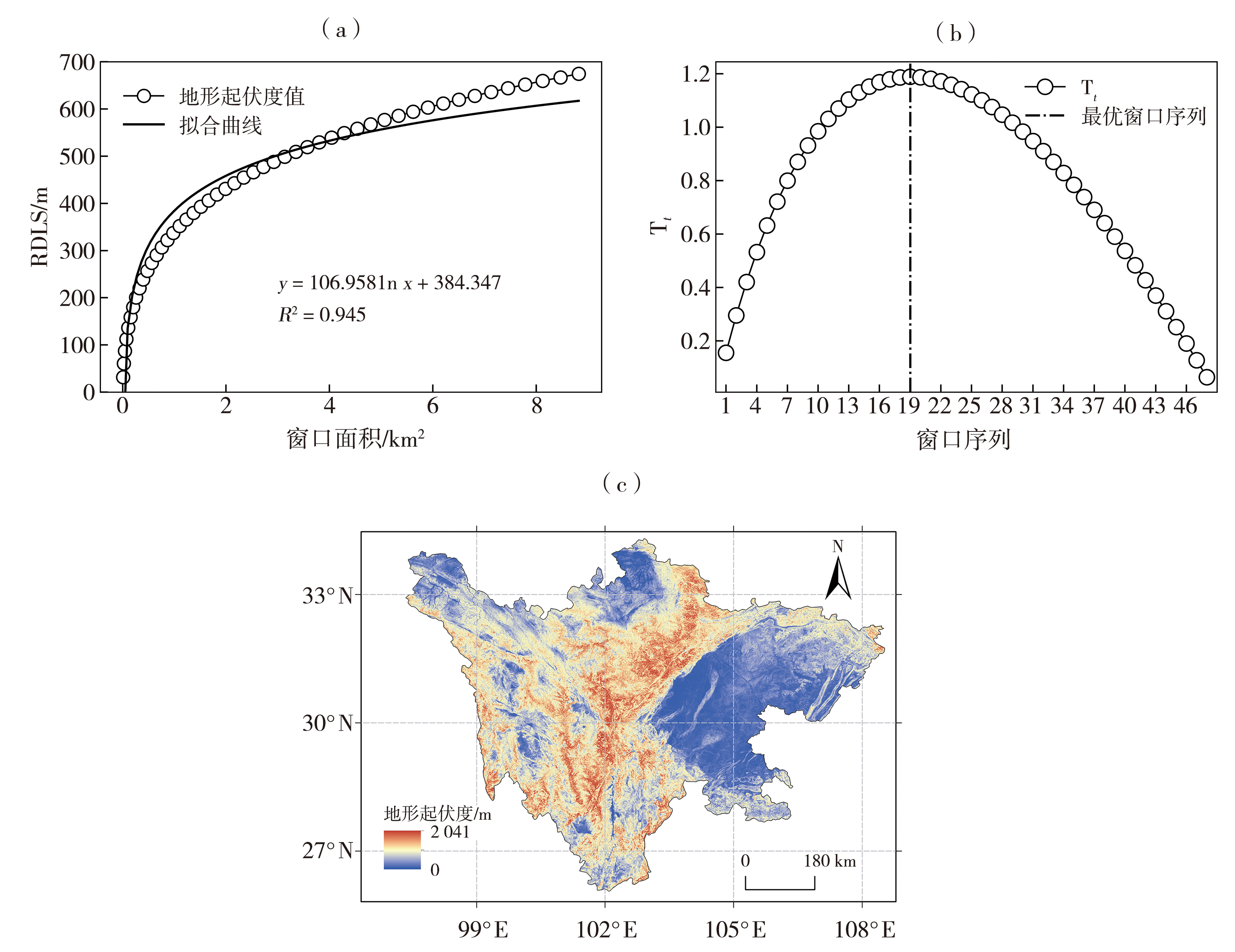
Fig.3 Fitting curve of the RDLS (a), change point curve (b) and optimal spatial pattern of the RDLS (c) in Sichuan Province
Fig.3 Fitting curve of the RDLS (a), change point curve (b) and optimal spatial pattern of the RDLS (c) in Sichuan Province
Tab.2 Number and proportion of meteorological observation stations in Sichuan Province under different types of the RDLS
| 站点类别 | 平原 | 台地 | 丘陵 | 小起伏山地 | 中起伏山地 | 大起伏山地 | 极大起伏山地 | |||||||
|---|---|---|---|---|---|---|---|---|---|---|---|---|---|---|
| 站数/个 | 占比/% | 站数/个 | 占比/% | 站数/个 | 占比/% | 站数/个 | 占比/% | 站数/个 | 占比/% | 站数/个 | 占比/% | 站数/个 | 占比/% | |
| 国家站 | 3 | 1.9 | 46 | 29.5 | 63 | 40.4 | 29 | 18.6 | 15 | 9.6 | 0 | 0.0 | 0 | 0.0 |
| 区域考核站 | 13 | 0.6 | 488 | 22.3 | 843 | 38.5 | 698 | 31.9 | 147 | 6.7 | 0 | 0.0 | 0 | 0.0 |
| 区域非考核站 | 59 | 2.0 | 554 | 19.1 | 873 | 30.1 | 1 114 | 38.4 | 293 | 10.1 | 6 | 0.2 | 0 | 0.0 |
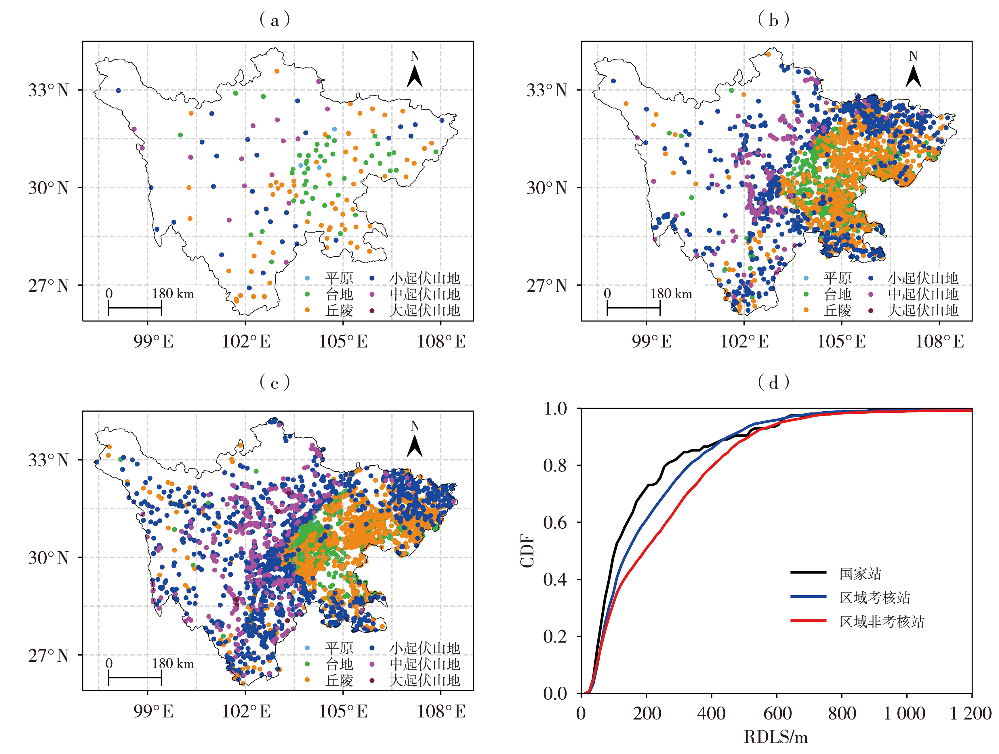
Fig.4 The spatial distribution of the RDLS of national stations (a), regional assessment stations (b), regional non-assessment stations (c) and the CDF of the number of different types meteorological stations with the change of the RDLS (d) in Sichuan Province
Fig.4 The spatial distribution of the RDLS of national stations (a), regional assessment stations (b), regional non-assessment stations (c) and the CDF of the number of different types meteorological stations with the change of the RDLS (d) in Sichuan Province
Tab.3 Regional representative evaluation of meteorological stations layout in Sichuan Province
| 区域代表性 | 像元数/个 | 面积/km2 | 面积占比/% |
|---|---|---|---|
| 高 | 51 422 649 | 46 280.38 | 8.75 |
| 适中 | 358 220 145 | 322 398.13 | 60.99 |
| 低 | 173 037 289 | 155 733.56 | 29.46 |
| 极低 | 4 689 806 | 4 220.83 | 0.80 |

Fig.5 Regional representative spatial pattern of the suitable meteorological stations in Sichuan Province
Fig.5 Regional representative spatial pattern of the suitable meteorological stations in Sichuan Province
Tab.4 The RDLS and regional representative evaluation of meteorological stations layout in various cities (prefectures) of Sichuan Province
| 序号 | 地区 | 地形起伏度/m | 区域代表性面积/km2 | |||||
|---|---|---|---|---|---|---|---|---|
| 平均起伏度 | 最小起伏度 | 最大起伏度 | 高 | 适中 | 低 | 极低 | ||
| 1 | 成都 | 179.7 | 14 | 1 404 | 7 283.3 | 4 395.9 | 1 523.8 | 65.9 |
| 2 | 自贡 | 88.2 | 13 | 372 | 2 190.1 | 2 477.0 | — | — |
| 3 | 泸州 | 225.1 | 18 | 936 | 2 001.3 | 10 116.8 | 425.9 | — |
| 4 | 德阳 | 181.9 | 19 | 1 532 | 2 899.6 | 2 749.0 | 793.7 | 45.9 |
| 5 | 绵阳 | 358.0 | 9 | 1 754 | 2 283.0 | 12 391.9 | 7 611.3 | 131.3 |
| 6 | 广元 | 330.4 | 0 | 1 104 | 32.2 | 15 314.3 | 2 648.5 | 1.0 |
| 7 | 遂宁 | 101.3 | 16 | 317 | 1 392.1 | 4 306.3 | — | — |
| 8 | 内江 | 90.6 | 20 | 414 | 2 405.7 | 3 298.6 | — | — |
| 9 | 乐山 | 322.8 | 15 | 1 671 | 1 862.4 | 8 748.0 | 3 049.8 | 54.9 |
| 10 | 南充 | 148.2 | 3 | 489 | 1 789.0 | 11 901.0 | — | — |
| 11 | 眉山 | 146.5 | 5 | 1 339 | 3 588.1 | 3 668.7 | 455.3 | 2.0 |
| 12 | 宜宾 | 216.1 | 19 | 911 | 2 097.4 | 11 277.3 | 552.3 | — |
| 13 | 广安 | 132.8 | 20 | 859 | 2 006.5 | 4 613.8 | 69.9 | — |
| 14 | 达州 | 276.7 | 17 | 1 325 | 1 679.0 | 14 407.6 | 1 770.5 | 12.7 |
| 15 | 雅安 | 542.8 | 16 | 1 613 | 291.4 | 6 412.6 | 9 420.0 | 290.8 |
| 16 | 巴中 | 325.8 | 40 | 1 004 | 20.6 | 12 057.0 | 1 484.0 | — |
| 17 | 资阳 | 79.9 | 3 | 392 | 4 011.1 | 4 462.5 | — | — |
| 18 | 阿坝 | 461.9 | 0 | 1 741 | 4 859.9 | 46 115.1 | 40 059.9 | 1 058.4 |
| 19 | 甘孜 | 440.8 | 4 | 1 915 | 2 845.1 | 101 828.7 | 57 227.2 | 1 723.1 |
| 20 | 凉山 | 478.4 | 0 | 2 041 | 738.0 | 36 060.4 | 26 282.0 | 866.2 |
| 21 | 攀枝花 | 423.6 | 27 | 1 285 | 4.3 | 5 342.3 | 2 318.1 | 10.1 |
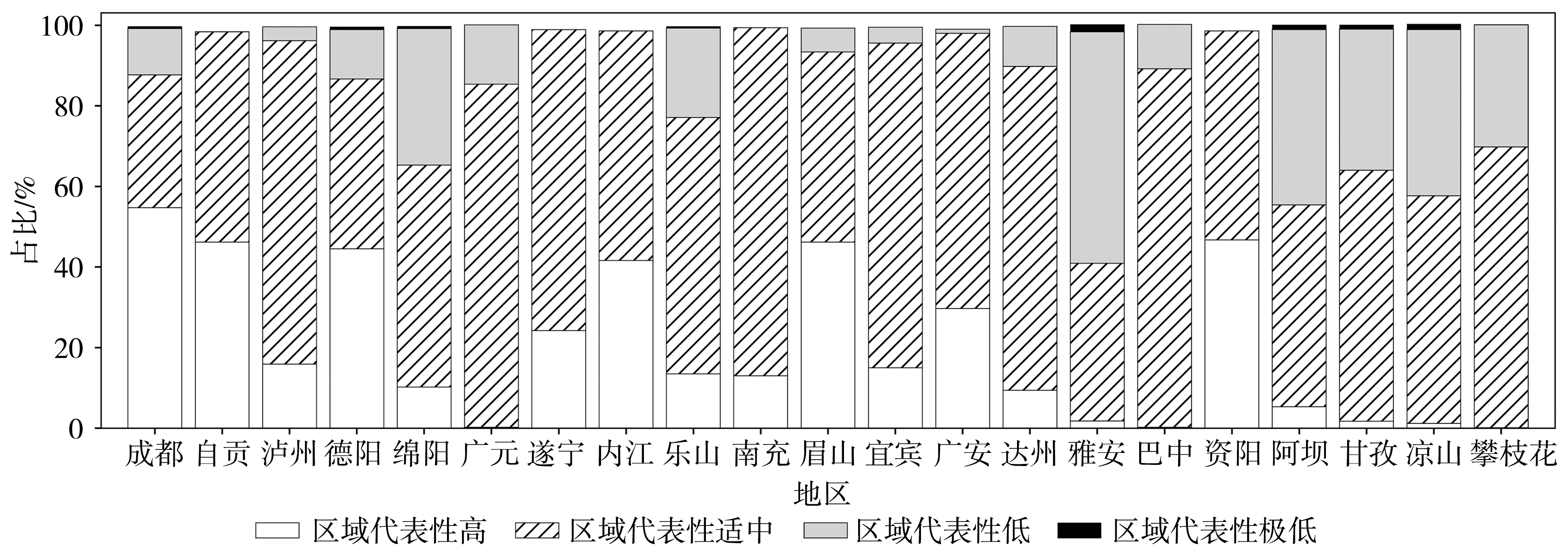
Fig.6 Proportion of different regional representative of meteorological stations layout in cities (prefectures) of Sichuan Province
Fig.6 Proportion of different regional representative of meteorological stations layout in cities (prefectures) of Sichuan Province
| [1] | 查瑞生, 陈梦琳, 赵晓雪, 2014. 基于地形起伏度的南川区人居环境地形适宜性评价[J]. 西南大学学报(自然科学版), 36(10): 150-156. |
| [2] | 陈学兄, 常庆瑞, 毕如田, 等, 2018. 地形起伏度最佳统计单元算法的比较研究[J]. 水土保持研究, 25(1): 52-56. |
| [3] | 程勇, 杨玲, 行鸿彦, 等, 2011. 气象台站网布局优化研究综述[J]. 南京信息工程大学学报(自然科学版), 3(6): 511-518. |
| [4] |
范建容, 张子瑜, 李立华, 2015. 四川省山地类型界定与山区类型划分[J]. 地理研究, 34(1): 65-73.
DOI |
| [5] | 封志明, 李文君, 李鹏, 等, 2020. 青藏高原地形起伏度及其地理意义[J]. 地理学报, 75(7): 1 359-1 372. |
| [6] | 郭佳, 李晋东, 刘艳祯, 2020. 基于不同水平分辨率DEM的数字地形分析研究[J]. 测绘与空间地理信息, 43(12): 214-216. |
| [7] | 巩庆, 马明杰, 蒋聚金, 等, 2023. 塔克拉玛干沙漠热力浮尘天气特征初步研究[J]. 沙漠与绿洲气象, 17(5): 147-152. |
| [8] |
韩海辉, 高婷, 易欢, 等, 2012. 基于变点分析法提取地势起伏度——以青藏高原为例[J]. 地理科学, 32(1): 101-104.
DOI |
| [9] | 后立胜, 蔡运龙, 2004. 土地利用/覆被变化研究的实质分析与进展评述[J]. 地理科学进展, 23(6): 96-104. |
| [10] | 黄晓龙, 徐晓莉, 吴薇, 等, 2022. 基于DEM的四川省地面气象台站地形特征分析[J]. 高原山地气象研究, 42(1): 135-142. |
| [11] | 郎玲玲, 程维明, 朱启疆, 等, 2007. 多尺度DEM提取地势起伏度的对比分析——以福建低山丘陵区为例[J]. 地球信息科学, (6): 1-6+135-136. |
| [12] | 李炳元, 潘保田, 韩嘉福, 2008. 中国陆地基本地貌类型及其划分指标探讨[J]. 第四纪研究, 28(4): 535-543. |
| [13] |
李想, 李国平, 2022. 四川夏季降水量空间插值方法的比较[J]. 干旱气象, 40(5): 897-907.
DOI |
| [14] | 卢萍, 李英, 2012. 不同地形资料对西南涡降水过程的数值模拟研究[J]. 高原山地气象研究, 32(2): 20-25. |
| [15] | 任芝花, 张志富, 孙超, 等, 2015. 全国自动气象站实时观测资料三级质量控制系统研制[J]. 气象, 41(10):1268-1 277. |
| [16] | 汤国安, 2014. 我国数字高程模型与数字地形分析研究进展[J]. 地理学报, 69(9): 1 305-1 325. |
| [17] | 王玲, 同小娟, 2007. 基于变点分析的地形起伏度研究[J]. 地理与地理信息科学, 23(6): 65-67. |
| [18] | 王国胜, 何清, 金莉莉, 等, 2022. 塔克拉玛干沙漠沙垄起伏地形夏季地表温度差异特征[J]. 沙漠与绿洲气象, 16(6): 131-140. |
| [19] | 吴利红, 康丽莉, 陈海燕, 等, 2007. 地面气象站环境变化对气温序列均一性影响[J]. 气象科技, 35(1): 152-156. |
| [20] |
吴薇, 黄晓龙, 徐晓莉, 等, 2023. 四川省降水实况分析产品影响因素综合评估[J]. 干旱气象, 41(1): 143-151.
DOI |
| [21] | 吴增祥, 臧海佳, 2007. 《气象台站历史沿革数据文件格式》标准设计[J]. 气象科技, 35(3): 439-441. |
| [22] | 徐保东, 李静, 柳钦火, 等, 2015. 地面站点观测数据代表性评价方法研究进展[J]. 遥感学报, 19(5): 703-718. |
| [23] | 许宝荣, 邹松兵, 刘勇, 等, 2015. GIS支持下黑河流域降水台站的地形代表性[J]. 兰州大学学报(自然科学版), 51(2): 166-172. |
| [24] |
杨丽杰, 曹彦超, 刘维成, 等, 2022. 陇东黄土高原旱区短时强降水的时空分布特征及地形影响研究[J]. 干旱气象, 40(6): 945-953.
DOI |
| [25] |
杨振鑫, 孙磊, 牛润和, 等, 2017. 甘肃省气象探测环境现状调查评估及保护措施[J]. 干旱气象, 35(4): 702-707.
DOI |
| [26] | 周芳弛, 李国平, 黄楚惠, 2023. 四川山地暖季夜间暴雨的空间分布以及对海拔高度的依赖性[J]. 沙漠与绿洲气象, 17(4): 79-87. |
| [27] | 张锦明, 游雄, 2013. 地形起伏度最佳分析区域预测模型[J]. 遥感学报, 17(4): 728-741. |
| [28] | 张颖, 赵宇鸾, 2016. 基于DEM的横断山县域山区类型划分[J]. 贵州师范大学学报(自然科学版), 34(6): 8-14. |
| [29] | 中国科学院地貌图集编辑委员会, 2009. 中华人民共和国地貌图集[M]. 北京: 科学出版社. |
| [30] | 钟静, 卢涛, 2018. 中国西南地区地形起伏度的最佳分析尺度确定[J]. 水土保持通报, 38(1): 175-181+186. |
| [31] | 朱明, 张静静, 马贺, 等, 2020. 基于DEM和均值变点法的伏牛山区地形起伏度分析[J]. 河南大学学报(自然科学版), 50(1): 36-43. |
| [32] | 曾超, 2021. 基于典型地形指标和地貌实体单元的四川省地貌形态自动分类及分区[J]. 山地学报, 39(4): 587-599. |
| [33] |
FENG Z M, YANG Y Z, ZHANG D, et al, 2009. Natural environment suitability for human settlements in China based on GIS[J]. Journal of Geographical Sciences, 19(4): 437-446.
DOI URL |
| [34] |
SLAYMAKER O, 2001. The role of remote sensing in geomorphology and terrain analysis in the Canadian Cordillera[J]. International Journal of Applied Earth Observation and Geoinformation, 3(1): 11-17.
DOI URL |
| [35] |
LIU Y, DENG W, SONG X Q, 2015. Relief degree of land surface and population distribution of mountainous areas in China[J]. Journal of Mountain Science, 12(2): 518-532.
DOI URL |
| Viewed | ||||||
|
Full text |
|
|||||
|
Abstract |
|
|||||