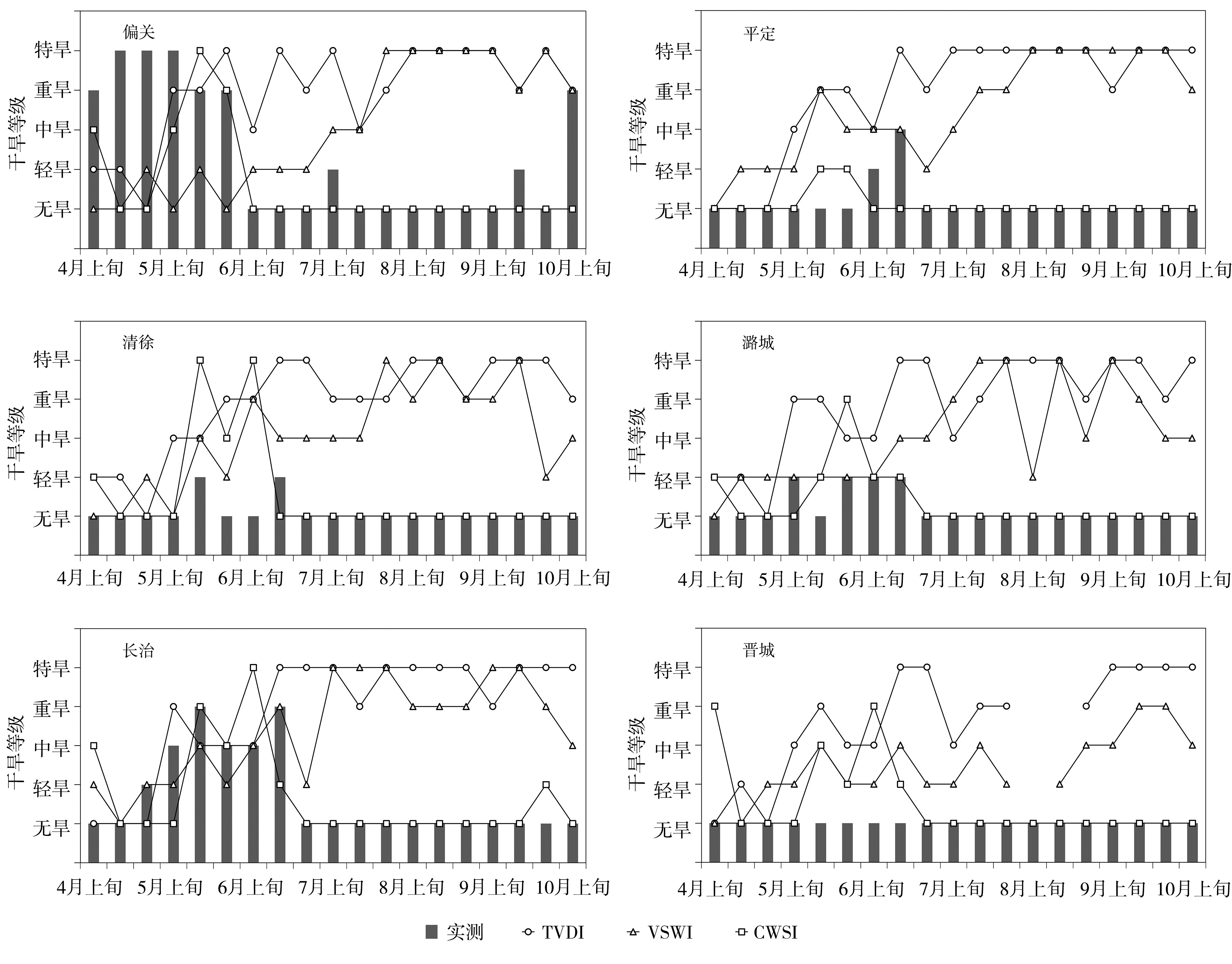
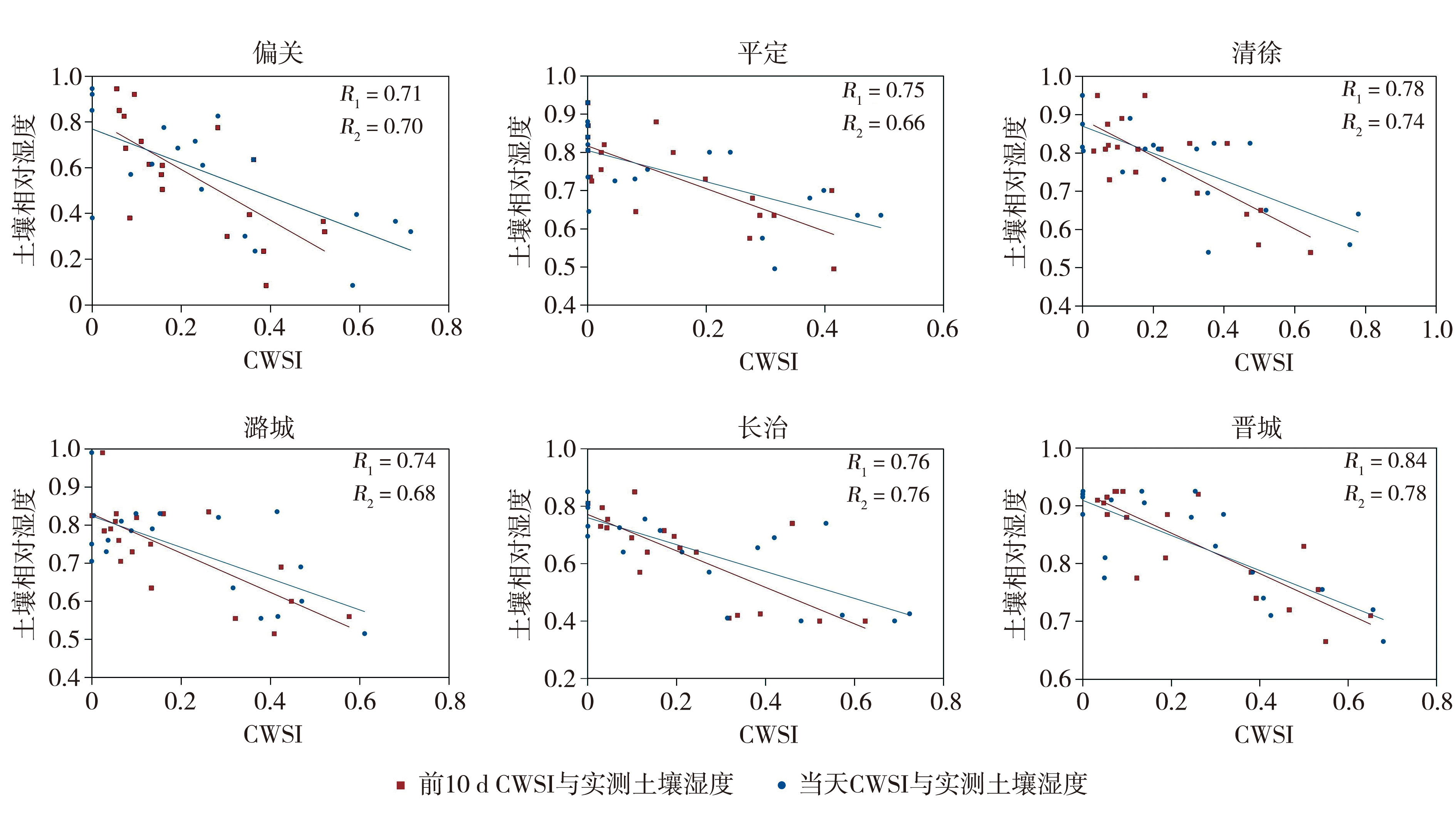
| [1] |
陈国茜, 祝存兄, 李林, 等, 2018. 青海高寒草地区曲麻莱县遥感干旱指数的适用性研究[J]. 干旱气象, 36(6): 905-910.
|
| [2] |
陈亮, 张超, 常斌, 等, 2019. 通用温度-植被指数特征空间农田干旱遥感监测[J]. 遥感信息, 34(5): 29-34.
|
| [3] |
高彦春, 龙笛, 2008. 遥感蒸散发模型研究进展[J]. 遥感学报, 12(3): 515-528.
|
| [4] |
郭铌, 王小平, 2015. 遥感干旱应用技术进展及面临的技术问题与发展机遇[J]. 干旱气象, 33(1): 1-18.
DOI
|
| [5] |
国家气候中心, 中国气象局预报与网络司,中国气象局兰州干旱气象研究所, 2017. 气象干旱等级:GB/T20481—2017[S]. 北京: 中国标准出版社.
|
| [6] |
李芬, 张建新, 武永利, 等, 2013. 近50年山西终霜冻的时空分布及其影响因素[J]. 地理学报, 68(11): 1 472-1 480.
|
| [7] |
梁任刚, 周旭, 李松, 等, 2022. 基于CWSI的贵州省干旱时空变化特征及影响因素分析[J]. 水土保持研究, 29(3): 284-291.
|
| [8] |
刘庆桐, 2005. 中国气象灾害大典: 山西卷[M]//温克刚. 中国气象灾害大典. 北京: 气象出版社: 10-11.
|
| [9] |
刘志明, 张柏, 晏明, 等, 2003. 土壤水分与干旱遥感研究的进展与趋势[J]. 地球科学进展, 18(4): 576-583.
DOI
|
| [10] |
马玉芬, 李火青, 2019. 不同土地利用数据对WRF模拟新疆高温天气的影响[J]. 沙漠与绿洲气象, 13(1):52-62.
|
| [11] |
钱锦霞, 王振华, 2008. 山西省春旱趋势及对农业的影响[J]. 自然灾害学报, 17(4): 105-110.
|
| [12] |
任兆鹏, 卢宇坤, 谢丰, 2020. 东北半干旱地区夏季能量水分传输过程分析[J]. 沙漠与绿洲气象, 14(3): 122-130
|
| [13] |
申广荣, 田国良, 2000. 基于GIS的黄淮海平原旱灾遥感监测研究-作物缺水指数模型的实现[J]. 生态学报, 20(2): 224-228.
|
| [14] |
史尚渝, 王飞, 金凯, 等, 2020. 黄土高原地区植被指数对干旱变化的响应[J]. 干旱气象, 38(1): 1-13.
|
| [15] |
汪左, 王芳, 张运, 2018. 基于CWSI的安徽省干旱时空特征及影响因素分析[J]. 自然资源学报, 33(5): 853-866.
DOI
|
| [16] |
王丽娟, 郭铌, 沙莎, 等, 2016. 混合像元对遥感干旱指数监测能力的影响[J]. 干旱气象, 34(5): 772-778.
DOI
|
| [17] |
王玲玲, 何巍, 罗米娜, 等, 2021. 基于归一化旱情综合指数的川西高原草地伏旱监测分析[J]. 干旱气象, 39(6): 884-893.
|
| [18] |
王万同, 2012. 基于遥感技术的区域地表蒸散估算研究——以伊洛河流域为例[D]. 开封: 河南大学.
|
| [19] |
王小平, 郭铌, 2003. 遥感监测干旱的方法及研究进展[J]. 干旱气象, 21(4): 76-81.
|
| [20] |
王玉娟, 王树东, 曾红娟, 等, 2014. 基于作物缺水指数法的渭河流域干旱特征[J]. 干旱区研究, 31(1): 118-124.
|
| [21] |
王志伟, 武永利, 2019. 农业干旱卫星遥感监测预报技术研究[M]. 北京: 气象出版社.
|
| [22] |
武永利, 相栋, 2013. FY2号气象卫星估算地面太阳辐射研究[J]. 自然资源学报, 28(12): 2 117-2 126.
|
| [23] |
谢婷, 马育军, 张午朝, 2021. 青海湖北岸大气向下长波辐射特征及云的影响[J]. 干旱气象, 39(2): 288-295.
|
| [24] |
易雪, 杨森, 刘鸣彦, 等, 2021. 辽宁省植被覆盖度时空变化特征及其对气候变化的响应[J]. 干旱气象, 39(2): 252-261.
|
| [25] |
张红卫, 陈怀亮, 申双和, 等, 2010. NDVI-ST特征空间及干湿边变化特征[J]. 气象科技, 38(1): 86-95.
|
| [26] |
张小平, 秦璐, 范卫东, 等, 2022. 山西最大冻土深度时空分布特征[J]. 干旱气象, 40(1): 49-54.
DOI
|
| [27] |
张学艺, 李剑萍, 秦其明, 等, 2009. 几种干旱监测模型在宁夏的对比应用[J]. 农业工程学报, 25(8): 18-23.
|
| [28] |
张艳红, 吕厚荃, 李森, 2008. 作物水分亏缺指数在农业干旱监测中的适用性[J]. 气象科技, 36(5): 596-600.
|
| [29] |
赵杰鹏, 张显峰, 廖春华, 等, 2011. 基于TVDI的大范围干旱区土壤水分遥感反演模型研究[J]. 遥感技术与应用, 26(6): 742-750.
|
| [30] |
赵伟, 李召良, 2007. 利用MODIS/EVI时间序列数据分析干旱对植被的影响[J]. 地理科学进展, 26(6): 40-47.
|
| [31] |
赵亚迪, 刘永和, 李建林, 等, 2018. 1960—2013年中国地表潜在蒸散发时空变化及其对气象因子的敏感性[J]. 沙漠与绿洲气象, 12(3): 1-9.
|
| [32] |
CARLSON T N, GILLIES R R, PERRY E M, 1994. A method to make use of thermal infrared temperature and NDVI measurements to infer surface soil water content and fractional vegetation cover[J]. Remote Sensing Review, 9(1/2): 161-173.
|
| [33] |
GOETZ S J, 1997. Multi-sensor analysis of NDVI, surface temperature and biophysical variables at a mixed grassland site[J]. International Journal of Remote Sensing, 18(1): 71-94.
|
| [34] |
HU X, SHI L, LIN L, et al, 2019. Nonlinear boundaries of land surface temperature-vegetation index space to estimate water deficit index and evaporation fraction[J]. Agricultural and Forest Meteorology, 279, 107736. DOI: 10. 1016/j.agrformet.2019.107736.
|
| [35] |
JACKSON R D, IDSO S B, REGINATO R J, et al, 1981. Canopy temperature as a crop water stress indicator[J]. Water Resources Research, 17(4): 1 133-1 138.
|
| [36] |
JIANG Y, TANG R, JIANG X, et al, 2019. Impact of clouds on the estimation of daily evapotranspiration from MODIS-derived instantaneous evapotranspiration using the constant global shortwave radiation ratio method[J]. International Journal of Remote Sensing, 40(5/6): 1 930-1 944.
|
| [37] |
LAMBIN E F, EHRLICH D, 1996. The surface temperature-vegetation index space for land cover and land-cover change analysis[J]. International Journal of Remote Sensing, 17(3): 463-487.
|
| [38] |
MA Z C, SUN P, ZHANG Q, et al, 2021. Characterization and evaluation of MODIS-derived crop water stress index (CWSI) for monitoring drought from 2001 to 2017 over Inner Mongolia[J]. Sustainability, 13(2): 916. DOI:10.3390/su13020916.
|
| [39] |
MENENTI M, CHOUDHURY B J, 1993. Parameterization of land surface evaporation by means of location dependent potential evaporation and surface temperature range[C]// Yokohama: Progress in Physical Geography.
|
| [40] |
OKE T R, JOHNSON G T, STEYN D G, et al, 1991. Simulation of surface urban heat islands under ‘ideal’ conditions at night part 2: Diagnosis of causation[J]. Boundary-Layer Meteorology, 56(4): 339-358.
|
| [41] |
PRICE J C, 1990. Using spatial context in satellite data to infer regional scale evapotranspiration[J]. IEEE Transactions on Geoscience and Remote Sensing, 28(5): 940-948.
|
| [42] |
RICHARD G A, LUIS S P, DIRK R, et al. Crop evapotranspiration, FAO irrigation and drainage paper NO. 56[R]. Rome: FAO, 1998: 24-25.
|
| [43] |
SU Z, 2002. The Surface Energy Balance System (SEBS) for estimation of turbulent heat fluxes[J]. Hydrology and Earth System Sciences, 6(1): 85-100.
|
 ), 任玉欢1, 杨茜1, 黄小燕2(