Journal of Arid Meteorology ›› 2025, Vol. 43 ›› Issue (1): 1-10.DOI: 10.11755/j.issn.1006-7639-2025-01-0001
• Articles • Previous Articles Next Articles
A meteorological drought index based on cumulative precipitation and cumulative evaporation
PAN Yongdi1,2( ), XIAO Jingjing3(), PAN Yanhua4, SHI Jie5
- 1. Wenzhou Meteorological Bureau of Zhejiang Province,Wenzhou 325027,Zhejiang,China
2. Wenzhou Key Laboratory of Typhoon Observations & Forecasting,Wenzhou 325027,Zhejiang,China
3. Zhejiang Climate Center,Hangzhou 310052,China
4. Wencheng Meteorological Bureau of Zhejiang Province,Wencheng 325300,Zhejiang,China
5. Dingxi Agricultural Testing Station,Dingxi 743000,Gansu,China
-
Received:2024-06-07Revised:2024-07-23Online:2025-02-28Published:2025-03-14
一种基于累积降水与累积蒸发的气象干旱指数
- 1.浙江省温州市气象局,浙江 温州 325027
2.温州市台风监测预报技术重点实验室,浙江 温州 325027
3.浙江省气候中心,浙江 杭州 310052
4.浙江省文成县气象局,浙江 文成 325300
5.甘肃省定西市农试站,甘肃 定西 743000
-
通讯作者:肖晶晶(1984—),男,主要从事作物气象及干旱风险研究。E-mail:xiojingjing2005@163.com。 -
作者简介:潘永地(1971—),男,正高级工程师,硕士,主要从事农业气象方面研究。E-mail:648679519@qq.com。 -
基金资助:浙江省基础公益计划项目(LGF22D050007);浙江省气象局重点项目(2022ZD07)
CLC Number:
Cite this article
PAN Yongdi, XIAO Jingjing, PAN Yanhua, SHI Jie. A meteorological drought index based on cumulative precipitation and cumulative evaporation[J]. Journal of Arid Meteorology, 2025, 43(1): 1-10.
潘永地, 肖晶晶, 潘彦华, 石界. 一种基于累积降水与累积蒸发的气象干旱指数[J]. 干旱气象, 2025, 43(1): 1-10.
share this article
Add to citation manager EndNote|Ris|BibTeX
URL: http://www.ghqx.org.cn/EN/10.11755/j.issn.1006-7639-2025-01-0001
Tab.1 Classification of drought grades based on soil relative moisture
| 10~20 cm深度土壤相对湿度(R) | 干旱等级 |
|---|---|
| R>60% | 无旱 |
| 50%<R≤60% | 轻旱 |
| 40%<R≤50% | 中旱 |
| 30%<R≤40% | 重旱 |
| R≤30% | 特旱 |
Tab.1 Classification of drought grades based on soil relative moisture
| 10~20 cm深度土壤相对湿度(R) | 干旱等级 |
|---|---|
| R>60% | 无旱 |
| 50%<R≤60% | 轻旱 |
| 40%<R≤50% | 中旱 |
| 30%<R≤40% | 重旱 |
| R≤30% | 特旱 |
Tab.2 Classification of drought grades based on dry soil layer thickness
| 干土层厚度(H)/cm | 干旱等级 |
|---|---|
| H<5 | 无旱 |
| 5≤H<10 | 轻旱 |
| 10≤H<15 | 中旱 |
| 15≤H<20 | 重旱 |
| H≥20 | 特旱 |
Tab.2 Classification of drought grades based on dry soil layer thickness
| 干土层厚度(H)/cm | 干旱等级 |
|---|---|
| H<5 | 无旱 |
| 5≤H<10 | 轻旱 |
| 10≤H<15 | 中旱 |
| 15≤H<20 | 重旱 |
| H≥20 | 特旱 |
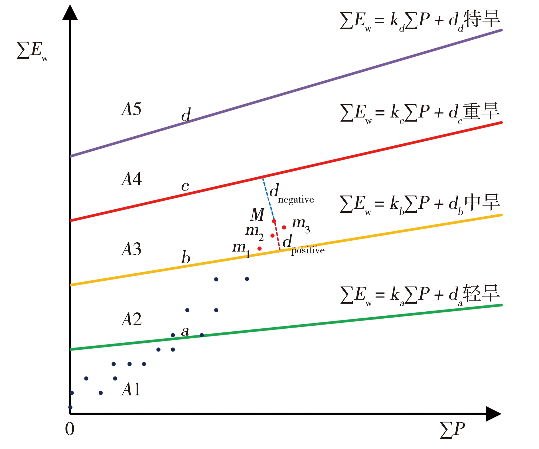
Fig.1 Schematic diagram of the conceptual model of soil drought grade distance index (Points,lines,etc.,see the article)
Fig.1 Schematic diagram of the conceptual model of soil drought grade distance index (Points,lines,etc.,see the article)
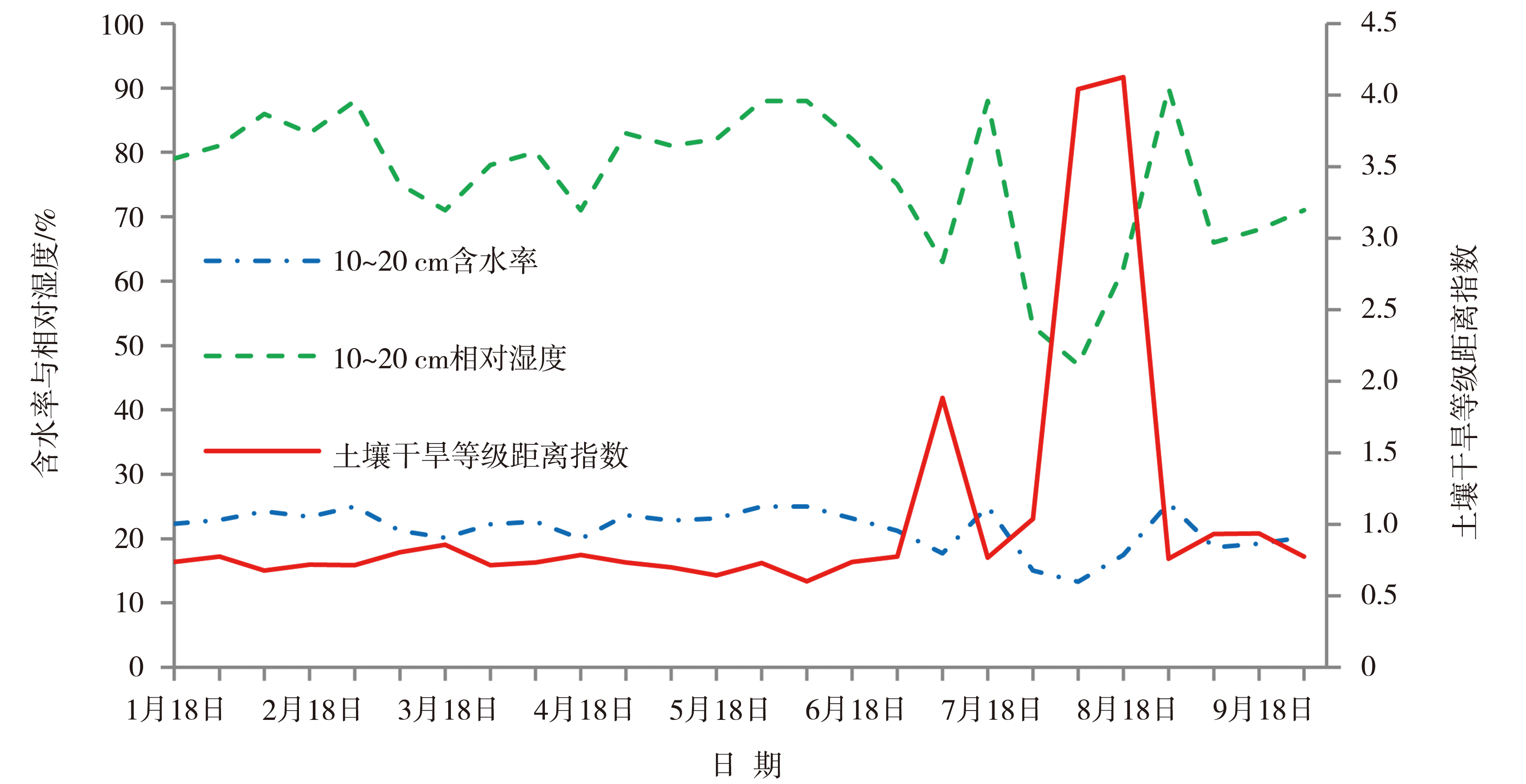
Fig.2 Evolution of soil drought grade distance index,soil water content,and soil relative moisture at Pingyang Station from January to September in 2013
Fig.2 Evolution of soil drought grade distance index,soil water content,and soil relative moisture at Pingyang Station from January to September in 2013
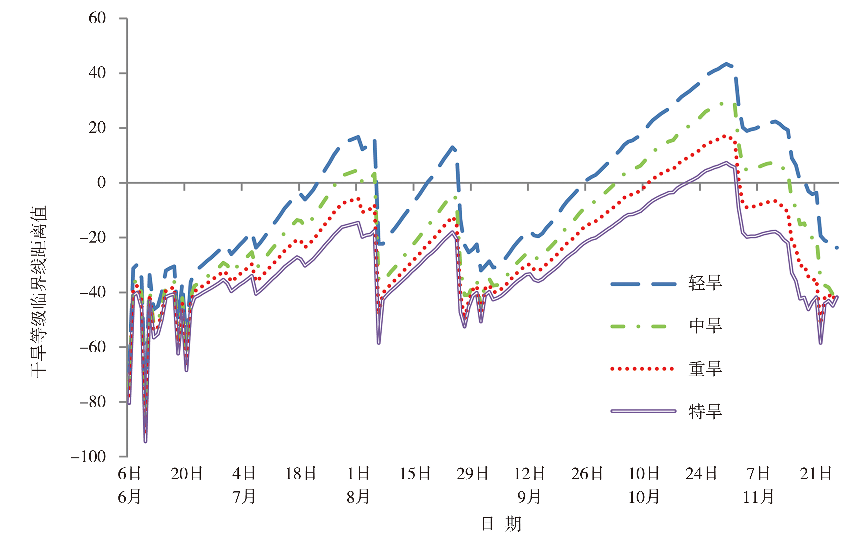
Fig.3 Daily variation of critical line distance for soil drought at Wenzhou Station from June 6 to December 31,2022
Fig.3 Daily variation of critical line distance for soil drought at Wenzhou Station from June 6 to December 31,2022
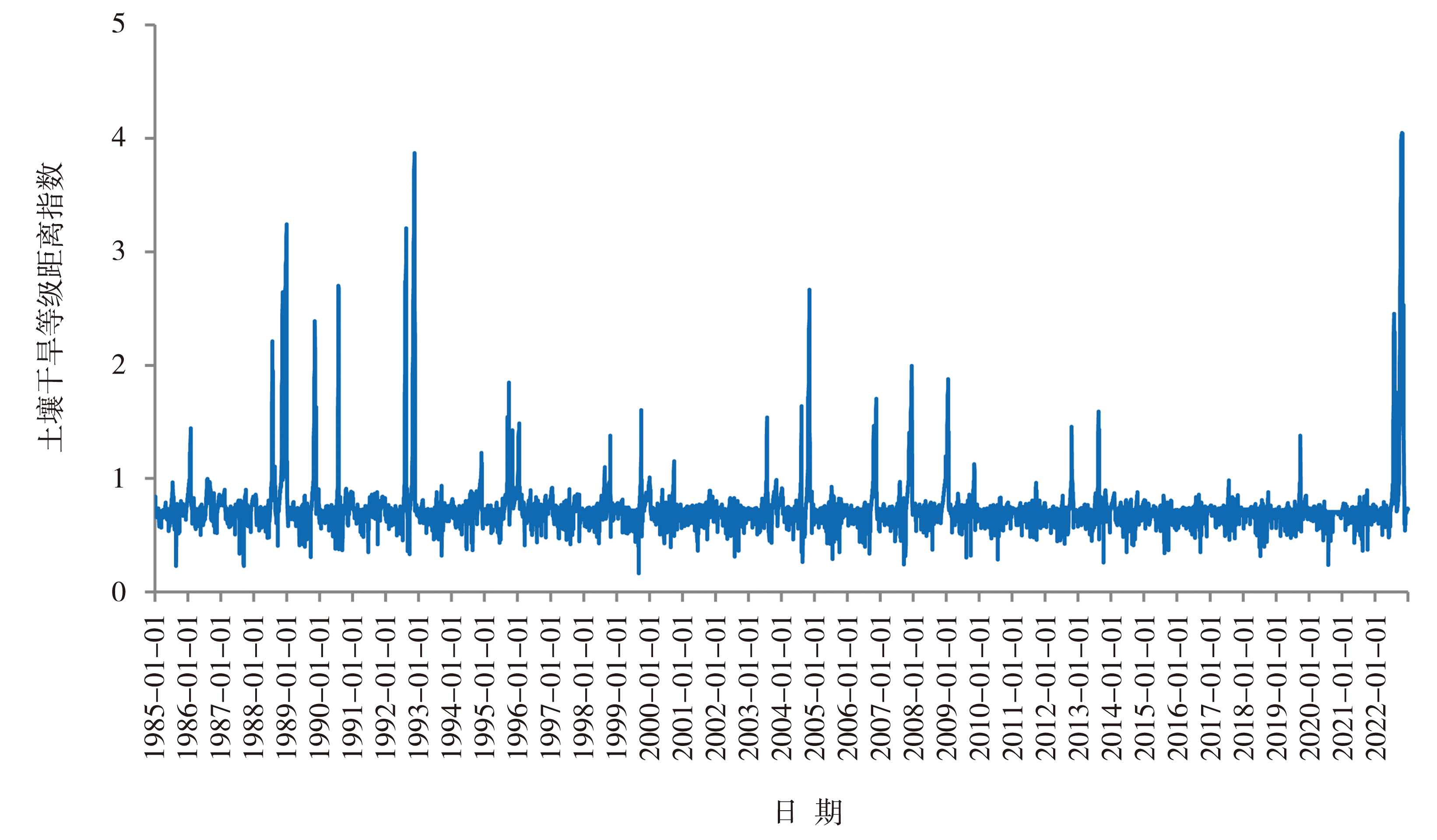
Fig.4 Daily variation of soil drought grade distance index from 1985 to 2022 at Wenzhou Station
Fig.4 Daily variation of soil drought grade distance index from 1985 to 2022 at Wenzhou Station
| [1] | 阿帕尔·肉孜, 阿吉古丽. 沙依提, 叶尔克江·霍依哈孜, 等, 2024. 基于SPI的1961-2020年昌吉地区作物生长季气象干旱时空特征研究[J]. 沙漠与绿洲气象, 18(2):163-168. |
| [2] | 陈灏, 张晓琳, 胡彩霞, 等, 2023. 基于GAMLSS模型的云南省非一致性标准化降水指数分析[J]. 水电能源科学, 41(4):9-12. |
| [3] | 傅抱璞, 1981. 土壤蒸发的计算[J]. 气象学报, 39(2):226-236. |
| [4] | 贺双燕, 杨晓静, 刘俊钊, 等, 2024. 2022年江西省干旱时空演变特征研究[J]. 中国水利水电科学研究院学报:中英文, 22(1):49-62. |
| [5] | 黄瑶, 何军, 甘薇薇, 等, 2023. 基于SPI的金沙江下游气象干旱时空分布特征及预测方法[J]. 高原山地气象研究, 43(2): 81-89. |
| [6] | 雷声, 全智平, 王能耕, 2023. 2022年江西省极端干旱回顾与思考[J]. 中国防汛抗旱, 33(4):1-6. |
| [7] | 李家誉, 佘敦先, 张利平, 等, 2022. 黄土高原植被变化对气象干旱多尺度响应特征与机制[J]. 水土保持学报, 36(6):280-289. |
| [8] |
廉泓林, 韩雪莹, 刘雅莉, 等, 2022. 基于标准化降水蒸散指数(SPEI)的毛乌素沙地1981—2020年干旱特征研究[J]. 中国沙漠,42(4):71-80.
DOI |
| [9] | 潘永地, 潘彦华, 王金瑞, 等, 2022. 基于卫星和数值预报产品计算短波辐射[J]. 亚热带资源与环境学报, 17(4):22-28. |
| [10] | 青海省气象局, 2017. 土壤干旱等级:DB63/T1578—2017[S]. 西宁: 青海省气象局. |
| [11] | 全国气候与气候变化标准化技术委员会, 2017.气象干旱等级: GB/T20481—2017[S]. 北京: 中国标准出版社. |
| [12] |
任至涵, 倪长健, 石荞语, 等, 2024. 基于最优概率分布函数的成都市近63 a干旱特征分析[J]. 干旱气象, 42(6): 844-853.
DOI |
| [13] | 商守卫, 王银堂, 崔婷婷, 等, 2022. 基于标准化降水指数的成都市气象干旱演变特征[J]. 水电能源科学, 40(12):26-29. |
| [14] | 宋刚勇, 胡洪浩, 杨茂松, 等, 2023. 2022年重庆市历史罕见干旱防御实践与思考[J]. 水利水电快报, 44(4):8-13. |
| [15] | 宋艳玲, 2022. 全球干旱指数研究进展[J]. 应用气象学报, 33(5):513-526. |
| [16] | 孙伟, 裘峰, 王丽萍, 等, 2023. 2022年贵州省干旱灾害应对与思考[J]. 水利水电快报, 44(4):24-27. |
| [17] | 唐怡, 卯昌书, 苏建广, 2023. 基于SPI指数的云南省干旱时空特征分析[J]. 水利水电快报, 44(2):17-23. |
| [18] |
王林, 陈文, 2014. 标准化降水蒸散指数在中国干旱监测的适用性分析[J]. 高原气象, 33(2):423-431.
DOI |
| [19] |
王姝, 李金建, 秦宁生, 2019. 基于历史帕默尔干旱指数(PDSI)数据集重建的长江源区过去706 a径流量[J]. 中国沙漠,39(3):126-135.
DOI |
| [20] |
王莺, 张强, 王劲松, 等, 2022. 21世纪以来干旱研究的若干新进展与展望[J]. 干旱气象, 40(4):549-566.
DOI |
| [21] | 温州市农业局, 2022. 温州市2022年干旱情况调查报告[R]. 温州: 温州市气象局. |
| [22] | 温州市气象局, 1985—2022. 温州市气候影响综合评价[R]. 温州: 温州市气象局. |
| [23] | 吴志勇, 程丹丹, 何海, 等, 2021. 综合干旱指数研究进展[J]. 水资源保护, 37(1):36-45. |
| [24] | 武荣盛, 侯琼, 杨玉辉, 等, 2021. 多时间尺度气象干旱指数在内蒙古典型草原的适应性研究[J]. 干旱气象, 39(2):177-184. |
| [25] | 杨家伟, 陈华, 侯雨坤, 等, 2019. 基于气象旱涝指数的旱涝急转事件识别方法[J]. 地理学报, 74(11):2358-2 370. |
| [26] | 杨晓静, 姜田亮, 刘燕龙, 等, 2023. 湖南省2022年干旱时空特征及旱灾防御策略研究[J]. 中国防汛抗旱, 33(4):7-14. |
| [27] | 张强, 李栋梁, 姚玉璧, 等, 2024. 干旱形成机制与预测理论方法及其灾害风险特征研究进展与展望[J]. 气象学报, 82(1):1-21. |
| [28] | 张强, 张良, 崔显成, 等, 2011. 干旱监测与评价技术的发展及其科学挑战[J]. 地球科学进展, 26(7):763-778. |
| [29] | 张瑜芳, 蔡树英, 蔡美娟, 1991. 表土低含水率条件下土壤非稳定蒸发研究[J]. 武汉水利电力学院学报, 24(2):157-164. |
| [30] | 郑超磊, 胡光成, 陈琪婷, 等, 2021. 遥感土壤水分对蒸散发估算的影响[J]. 遥感学报, 25(4):990-999. |
| [31] | 周丹, 张勃, 任培贵, 等, 2014. 基于标准化降水蒸散指数的陕西省近50 a干旱特征分析[J]. 自然资源学报, 29(4):677-688. |
| [32] |
朱占云, 张露萱, 李福刚, 等, 2024. 新安江流域气象干旱和水文干旱特征及两者之间的关系研究[J]. 干旱气象, 42(2):157-165.
DOI |
| [33] | ALLEY W M, 1984. The Palmer drought severity index: Limitations and assumptions[J]. Journal of Climate and Applied Meteorology, 23(7): 1 100-1 109. |
| [34] | ARSLAN O, 2021. Hydrological drought analysis for Bolu city with streamflow drought index[J]. International Scientific and Vocational Studies Journal, 5(2): 115-123. |
| [35] | CAMMALLERI C, ARIAS-MUÑOZ C, BARBOSA P, et al, 2021. A revision of the combined drought indicator (CDI) used in the European drought observatory (EDO)[J]. Natural Hazards and Earth System Sciences, 21(2): 481-495. |
| [36] | HAHM W J, DRALLE D N, SANDERS M, et al, 2022. Bedrock vadose zone storage dynamics under extreme drought: Consequences for plant water availability, recharge, and runoff[J]. Water Resources Research, 58(4): e2021WR031781. |
| [37] | TAREKE K A, AWOKE A G, 2022. Comparing surface water supply index and streamflow drought index for hydrological drought analysis in Ethiopia[J]. Heliyon, 8(12): e12000. DOI:10.1016/j.heliyon.2022.e12000. |
| [38] | LU E, 2009. Determining the start, duration, and strength of flood and drought with daily precipitation: Rationale[J]. Geophysical Research Letters, 36(12): L12707.DOI:10.1029/2009GL038817. |
| [39] | LYON B, 2004. The strength of El Niño and the spatial extent of tropical drought[J]. Geophysical Research Letters, 31(21): L21204. DOI:10.1029/2004GL020901. |
| [40] | MCKEE T B, DOESKEN N J, KLEIST J, 1993. The relationship of drought frequency and duration to times scales[C]// Proceedings of the 8th Conference on Applied Climatology,Anaheim, CA. Boston, MA: American Meteorological Society. |
| [41] | OYOUNALSOUD M S, ABDALLAH M, GOKHAN YILMAZ A, et al, 2023. A new meteorological drought index based on fuzzy logic: Development and comparative assessment with conventional drought indices[J]. Journal of Hydrology, 619: 129306. DOI:10.1016/j.jhydrol.2023.129306 |
| [42] | NOURANI V, 2022. Application of the artificial intelligence approach and remotely sensed imagery for soil moisture evaluation[J]. Hydrology Research, 53(5): 684-699. |
| [43] | PALMER W C, 1968. Keeping track of crop moisture conditions, nationwide: The new cropmoisture index[J]. Weatherwise, 21(4): 156-161. |
| [44] | PALMER W C, 1965. Meteorological Drought[R]. Research Paper No.45,Washion DC:U S Weather Bureau. |
| [45] | PRAJAPATI V K, KHANNA M, SINGH M, et al, 2021. Evaluation of time scale of meteorological, hydrological and agricultural drought indices[J]. Natural Hazards, 109(1): 89-109. |
| [46] | ZHANG Q, YAO Y B, LI Y H, et al, 2020. Causes and changes of drought in China: Research progress and prospects[J]. Journal of Meteorological Research, 34(3): 460-481. |
| [47] | VICENTE-SERRANO S M, BEGUERÍA S, LÓPEZ-MORENO J I, 2010. A multiscalar drought index sensitive to global warming: The standardized precipitation evapotranspiration index[J]. Journal of Climate, 23(7): 1 696-1 718. |
| [48] | ZHU Y, WANG W, SINGH V P, et al, 2016. Combined use of meteorological drought indices at multi-time scales for improving hydrological drought detection[J]. Science of the Total Environment, 571: 1 058-1 068. |
| [1] | YANG Xiaoling, SUN Xuying, YANG Jinhu, WU Wen, ZHAO Huihua, CHEN Jing. Identification and evolution characteristics of compound high-temperature and drought events in the Shiyang River Basin [J]. Journal of Arid Meteorology, 2024, 42(6): 836-843. |
| [2] | DENG Xingchen, YU Tong, SHEN Jiayi, ZHAO Xin, WANG Lin, ZHENG Fei. Impact of the 2023/2024 El Niño event on drought in the Panama Canal region [J]. Journal of Arid Meteorology, 2023, 41(6): 841-848. |
| [3] | WANG Ying, ZHANG Qiang, WANG Jinsong, HAN Lanying, WANG Suping, ZHANG Liang, YAO Yubi, HAO Xiaocui, WANG Sheng. New progress and prospect of drought research since the 21st century [J]. Journal of Arid Meteorology, 2022, 40(4): 549-566. |
| [4] | WU Rongsheng, HOU Qiong, YANG Yuhui, FENG Xuyu, LI Bin, ZHENG Fengjie. Applicability Evaluation of Multi-time-scales Meteorological Drought Indexes in Typical Steppe of Inner Mongolia [J]. Journal of Arid Meteorology, 2021, 39(2): 177-184. |
| [5] | GAO Ruina, WANG Suyan, GAO Na, ZUO Hejiang. Application Comparison of CI and MCI Drought Indexes in Ningxia [J]. Journal of Arid Meteorology, 2021, 39(2): 185-192. |
| [6] | LIU Haoye, DUAN Yuhui, LI Tongtong, WANG Zongmin. Observation Analysis on Cold Air Lake Structure in the Biathlon Venue for Beijing 2022 Winter Olympic Games [J]. Journal of Arid Meteorology, 2020, 38(6): 929-936. |
| [7] | HUANG Helou, DING Yeyi, TU Xiaoping, ZHAO Changyu, YAO Risheng. Impact of Urbanization on Extreme Temperature and Human Comfort Degree in Ningbo City [J]. Journal of Arid Meteorology, 2020, 38(03): 396-403. |
| [8] | WANG Siqi, ZHANG Xiang, CHEN Nengcheng, ZHOU Jiaxiang, HU Chuli, PENG Xiaoting. Monitoring and Comparison of Drought in Five Provinces of the Middle and Lower Reaches of the Yangtze River Based on the Multiple Drought Indices [J]. Journal of Arid Meteorology, 2019, 37(2): 209-217. |
| [9] | ZHU Li, LIU Rong, WEN Jun, ZHAO Min, WANG Chaoying. Climate Change and Drought Evolution in the Tao River Basin in the Past 50 Years [J]. Journal of Arid Meteorology, 2018, 36(2): 234-242. |
| [10] | GU Shuhong1,2, HU Jiamin1,2, GU Kun2,3, ZHANG Bo1,2,GU Xiaoping1,2, CHEN Zhongyun1,2, XU Yongling1,2. Research on Drought Monitoring of Dryland Agriculture Based on Soil Water Content Simulation in Guizhou Mountainous Area [J]. Journal of Arid Meteorology, 2017, 35(1): 29-35. |
| [11] | WANG Lijuan, GUO Ni, SHA Sha, HU Die,WANG Wei, DENG Zuqin, LIU Weigang. Effect of Mixed Pixel on Monitoring Ability of Remote Sensing Drought Index [J]. Journal of Arid Meteorology, 2016, 34(5): 772-778. |
| [12] | KANG Yanzhen1, WANG Shigong1,2, YANG Xu1,LI Jingxin3, XU Wenjun4, SHANG Kezheng1. Progress of Traffic Meteorological Researches About Monitoring and Forecasting Services on Express Highways [J]. Journal of Arid Meteorology, 2016, 34(4): 591-603. |
| [13] | WANG Junchao1, PENG Tao1,2, WANG Lijuan3. esign and Development of Elaborate Forecasting Platform About Precipitation and Hydrology in Small and Medium Watershed Based on Micaps3.1 [J]. Journal of Arid Meteorology, 2015, 33(4): 702-710. |
| [14] | GUO Ni, WANG Xiaoping. Advances and Developing Opportunities in Remote Sensing of Drought [J]. Journal of Arid Meteorology, 2015, 33(1): 1-18. |
| [15] | LI Jian,WANG Chenghai. Variation Characteristics of Visibility at Zhengzhou Airport During 2004 - 2012 [J]. Journal of Arid Meteorology, 2014, 32(5): 733-737. |
| Viewed | ||||||
|
Full text |
|
|||||
|
Abstract |
|
|||||