干旱气象 ›› 2023, Vol. 41 ›› Issue (6): 972-983.DOI: 10.11755/j.issn.1006-7639(2023)-06-0972

• 技术报告 • 上一篇    下一篇

陕南汉江盆地一次冷锋触发的短时强降水过程及预报检验


  1. 1. 陕西省气象台,陕西 西安 710014;

    2. 中国气象科学研究院灾害天气国家重点实验室,北京 100081;

    3. 高原与盆地暴雨旱涝灾害 四川省重点实验室,四川 成都 610072;

    4. 陕西省气象科学研究所,陕西 西安 710016;

    5. 新疆维吾尔自治区气象台,新疆 乌鲁木齐 830002

  • 收稿日期:2022-10-29 修回日期:2022-11-24 出版日期:2023-12-31 发布日期:2024-01-03
  • 通讯作者: 马永永(1990—),男,河南平顶山人,博士,高级工程师,主要从事资料同化、模式检验等研究。E-mail: ma-yong1990@163. com。
  • 作者简介:肖贻青(1990—),女,陕西渭南人,硕士,高级工程师,主要从事灾害性天气的机理及客观预报方法研究。 E-mail: xxyyqq1222@163. com
  • 基金资助:

    灾害天气国家重点实验室开放课题项目(2022LASW-B20)、中国气象局暴雨精细化分析和预报青年创新团队专项(CMA 2023QN05)、高原与盆地暴雨旱涝灾害四川省重点实验室开放研究基金项目(SZKT202210)及中国局创新发展专项项目(CXFZ 2023J031)

A short-time heavy precipitation process triggered by a cold front in the Hanjiang Basin of southern Shaanxi and its precipitation forecast verification

  1. 1. Shaanxi Meteorological Observatory, Xi’an 710014, China; 

    2. State Key Laboratory of Severe Weather, Chinese Academy of Meteorological Sciences, Beijing 100081, China; 

    3. Heavy Rain and Drought-Flood Disasters in Plateau and Basin Key Laboratory of Sichuan Province, Chengdu 610072, China; 

    4. Shaanxi Provincial Institute of Meteorological Science,Xi’an 710016, China; 

    5. Xinjiang Meteorological Observatory, Urumqi 830002, China

  • Received:2022-10-29 Revised:2022-11-24 Online:2023-12-31 Published:2024-01-03

摘要:

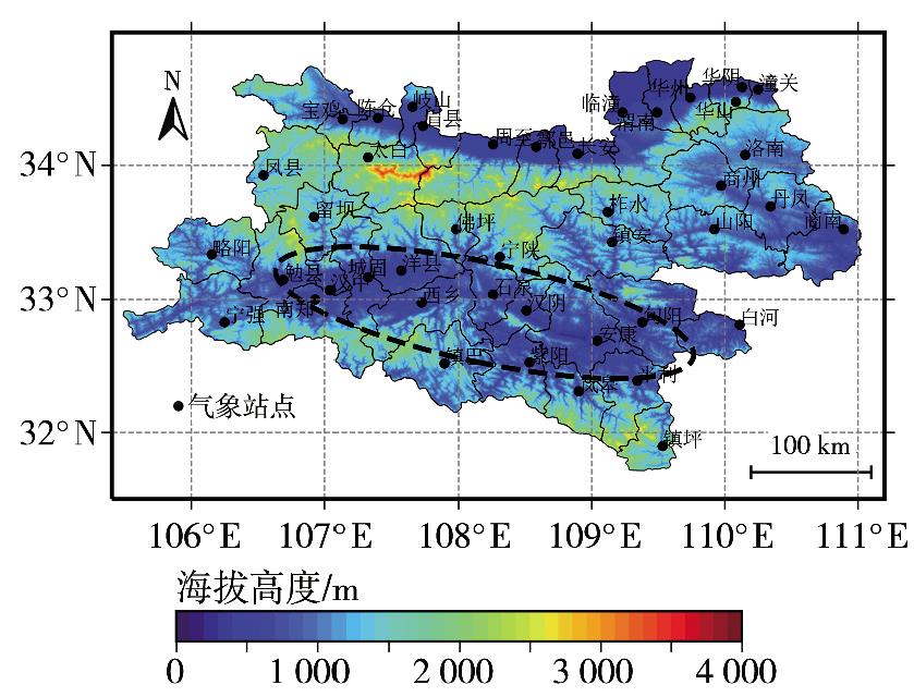
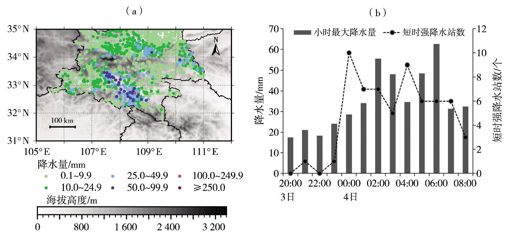
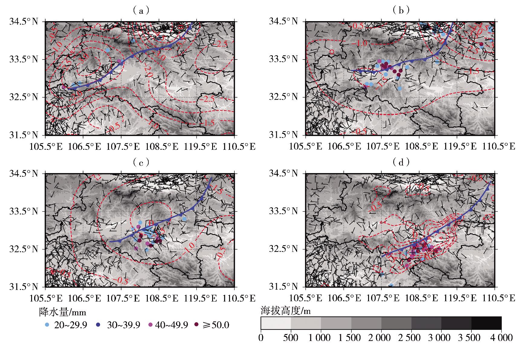
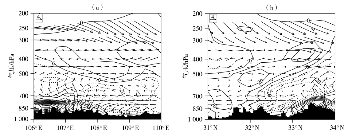
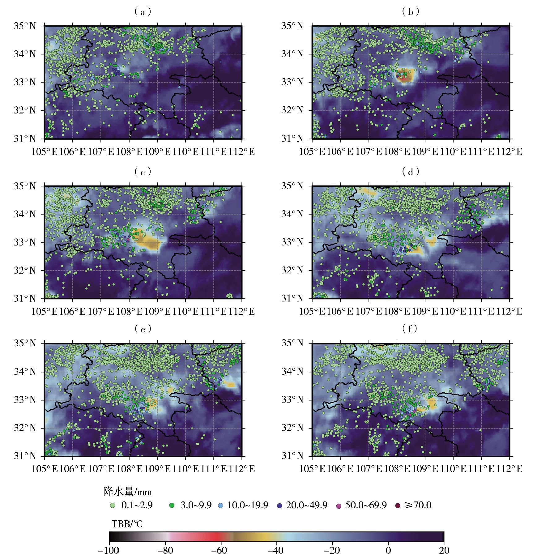
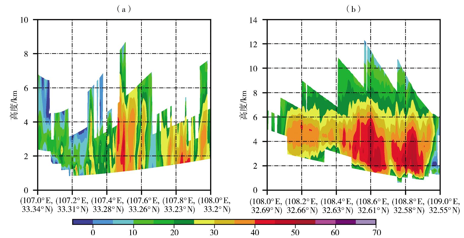
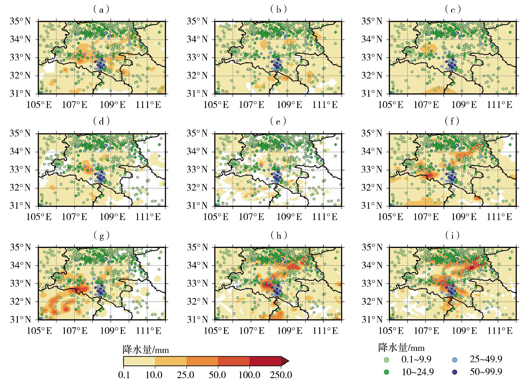
山区特殊地形下的强降水形成机理复杂、预报难度大,且此类强降水常导致严重的地质灾害。为提升特殊地形下强降水的预报能力,利用常规气象观测资料、欧洲中期天气预报中心(European Centre for Medium-Range Weather Forecasts,ECMWF)ERA5再分析资料、FY-4A卫星云图资料、多普勒雷达资料及多模式预报产品,对2022年6月3日夜间至4日清晨发生在陕南汉江盆地的局地短时强降水过程形成原因及模式预报性能进行检验分析。结果表明:(1)本次过程为一次锋面在盆地触发的短时强降水过程,由于对流不稳定层结浅薄、垂直风切变较弱,因此造成的强降水具有明显的局地性,但强度较大,12 h累计降水量多站超过50.0 mm,最大104.8 mm;(2)锋面两端受地形阻挡移动速度较慢并难以翻越高大山脉,因而不断在盆地内触发对流产生强降水,且在盆地近地层形成的次级环流可加强对流活动发展;(3)锋面前部形成的冷池在盆地不断触发新的对流单体后向传播形成列车效应,同时大于50 dBZ的强回波位于0 ℃层高度以下,具有较高的降水效率,且持续时间较长,因而带来最大62.6 mm·h-1 的短时强降水;(4)全球模式对此次短时强降水的预报能力有限,中尺度区域模式能够反映锋面对流的一些特征和降水,尤其是 CMA-TRAM(Tropical Regional Atmosphere Model for the SouthChina Sea)和 CMA-GD(China Meteorological Administration-Guangdong)模式能较好地反映局地强对流的触发及发展趋势,但对锋前冷池造成的对流系统强度和组织性仍预报偏差较大。

关键词:


Abstract:

It is difficult to forecast heavy precipitation under complex terrain in mountainous areas, which formation mechanism is complicated, and often brings serious geological disasters. Based on conventional observation data, European Centre for MediumRange Weather Forecasts ERA5 reanalysis data, FY-4A satellite cloud imagery, Doppler radar data and forecast products from various models, the factors contributing and model forecasting performance of local short-time heavy precipitation process in the Hanjiang Basin of southern Shaanxi from the night on 3 to the early morning on 4 June 2022 were examined and analyzed. The results are as follows:(1) This process is a short-time heavy precipitation triggered by the front in the Hanjiang Basin of southern Shaanxi. Due to shallow convection instability and weak vertical wind shear, the heavy precipitation exhibited localized characteristics with significant intensity. The accumulated precipitation in 12 hours exceeds 50 mm in many stations, with a maximum of 104. 8 mm. (2) The two ends of the front are blocked by the topography and move slowly and are difficult to cross the high mountains. Consequently, convection is continuously triggered within the basin, generating heavy precipitation, and the secondary circulation formed in the surface layer of the basin can enhance convective activity. (3) A cold pool formed in the front of front continuously triggers the backward propagation of new convective cells within the basin to form a train effect. Meanwhile, the intense radar reflectivity factor, exceeding 50 dBZ, is located below the 0 ℃ isotherm level, which has high precipitation efficiency and prolonged duration, thus bringing a short-time heavy precipitation with a maximum of 62. 6 mm·h-1 . (4) Global models displayed limited capability in forecasting this process, while mesoscale regional models can reflect the characteristics of frontal convection and precipitation, especially CMA-TRAM and CMA-GD models can reflect the triggering and development trend of local strong convection well. However, the intensity and organization of the convective system induced by the frontal cold pool of the front still have substantial forecast deviations.

Key words:

中图分类号: