干旱气象 ›› 2025, Vol. 43 ›› Issue (2): 231-241.DOI: 10.11755/j.issn.1006-7639-2025-02-0231

• 论文 • 上一篇    下一篇

四川盆地西部复杂地形小流域山洪径流模拟及其灾害成因分析

谢娜1(), 叶帮苹1(), 杨康权1,2, 陈军3, 康岚1,2, 范江琳1, 徐洋1   

  1. 1.四川省气象台,四川 成都 610072
    2.高原与盆地暴雨旱涝灾害四川省重点实验室,四川 成都 610072
    3.成都信息工程大学资源与环境学院,四川 成都 610225
  • 收稿日期:2024-09-25 修回日期:2025-02-22 出版日期:2025-04-30 发布日期:2025-05-13
  • 通讯作者: 叶帮苹(1988—),男,高级工程师,主要从事3S集成与气象应用。E-mail:gbcs567@qq.com。
  • 作者简介:谢娜(1981—),女,高级工程师,主要从事天气预报应用研究。E-mail:15717923@qq.com
  • 基金资助:
    四川省科技计划重点研发项目(2022YFS0542);中国气象局水文气象重点开放实验室开放研究课题(23SWQXM022);川西南(雅安)暴雨实验室科技发展基金项目(CXNBYSYSZD202402);四川省自然资源厅科研项目(ZDKJ-2024-006)

Simulation of runoff and analysis of disaster causes of flash floods in small watersheds with complex terrain in the western Sichuan Basin

XIE Na1(), YE Bangping1(), YANG Kangquan1,2, CHEN Jun3, KANG Lan1,2, FAN Jianglin1, XU Yang1   

  1. 1. Sichuan Province Meteorological Observatory, Chengdu 610072, China
    2. Heavy Rain and Drought-Flood Disasters in Plateau and Basin Key Laboratory of Sichuan Province, Chengdu 610072, China
    3. College of Resources and Environment, Chengdu University of Information Technology, Chengdu 610225, China
  • Received:2024-09-25 Revised:2025-02-22 Online:2025-04-30 Published:2025-05-13

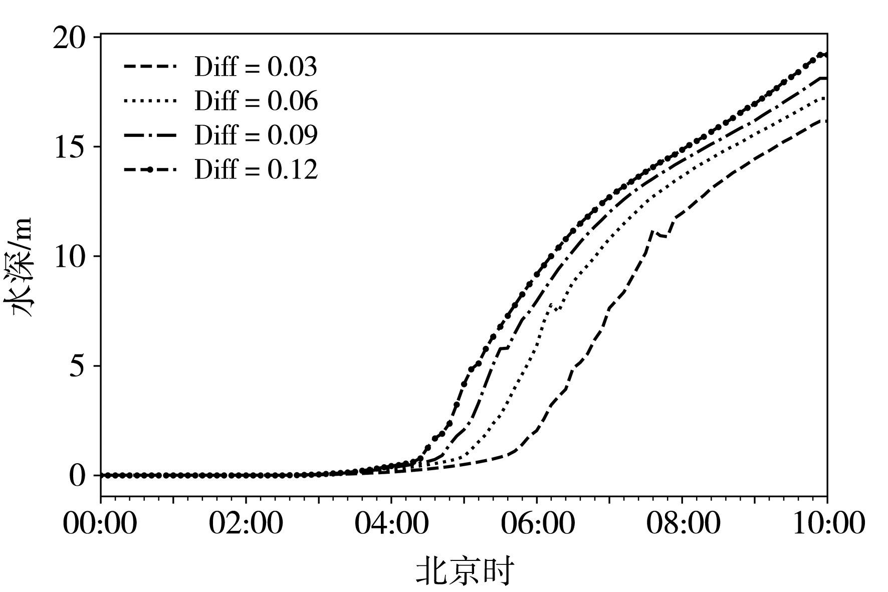
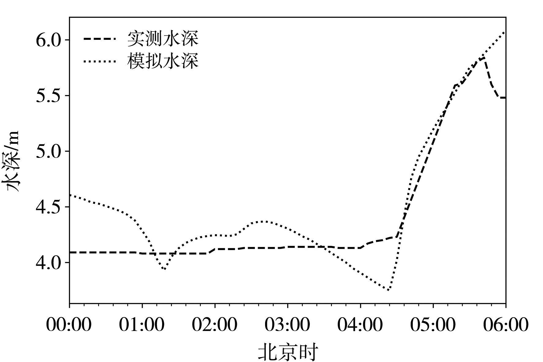
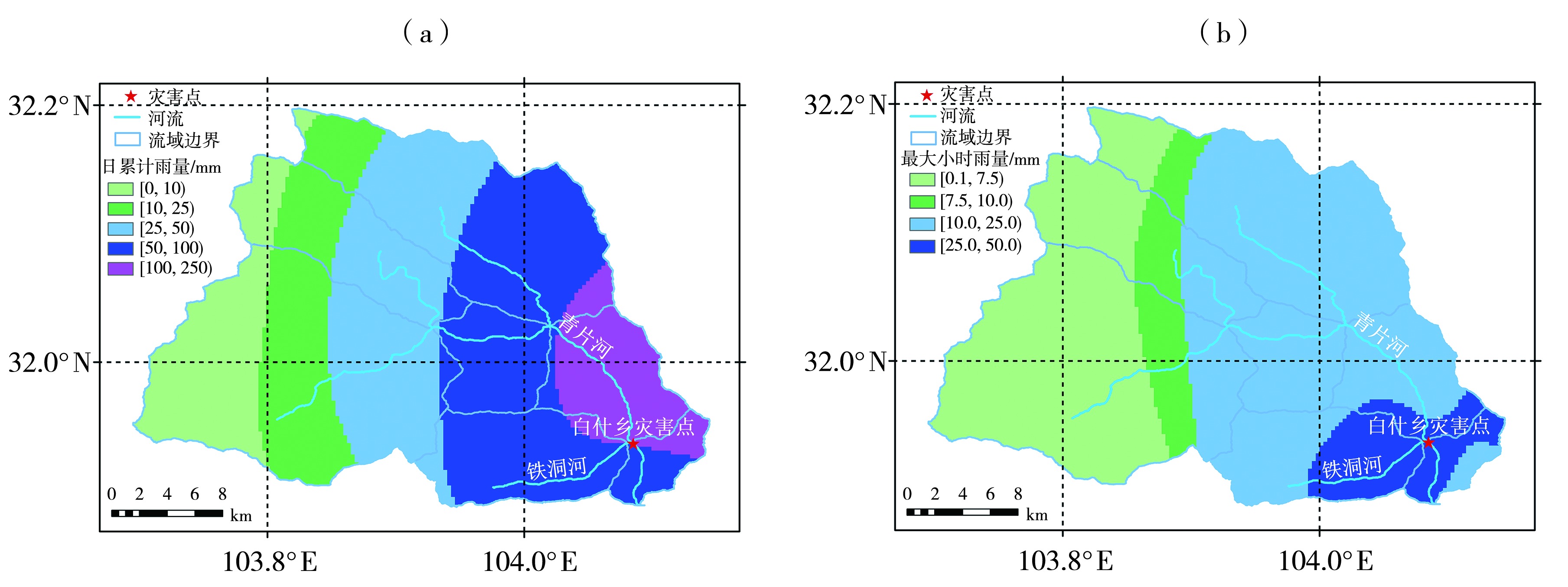
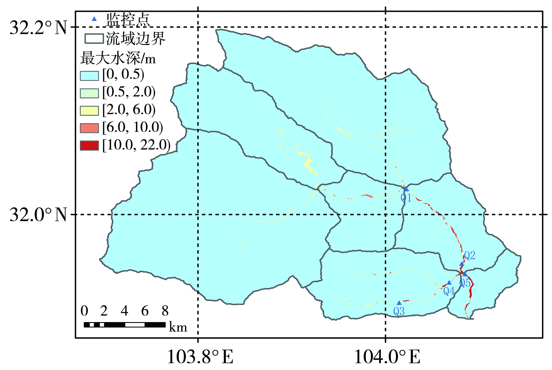
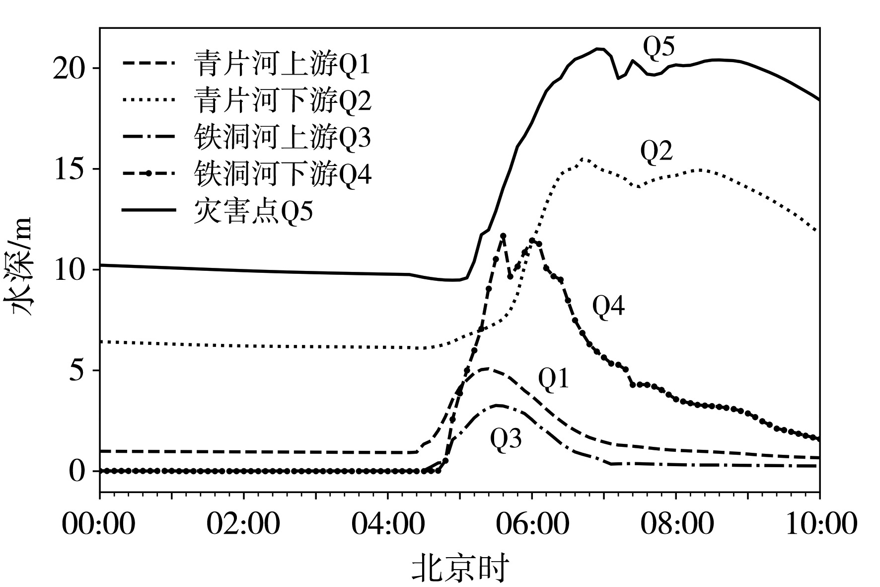
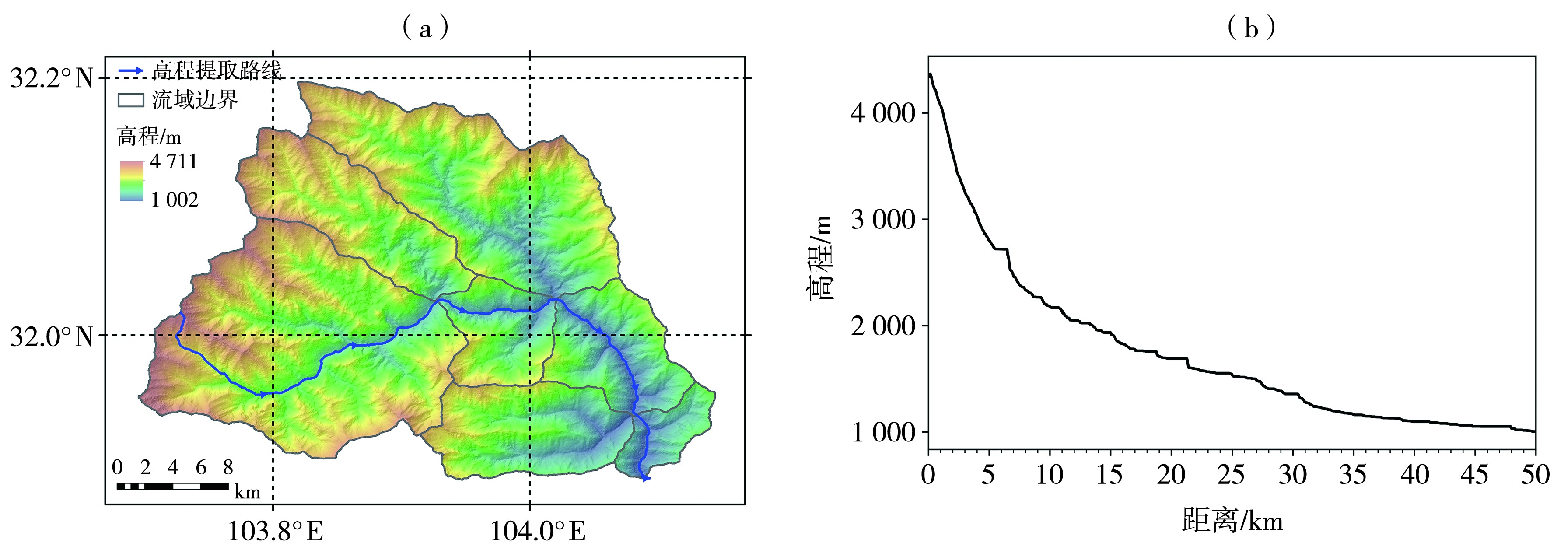
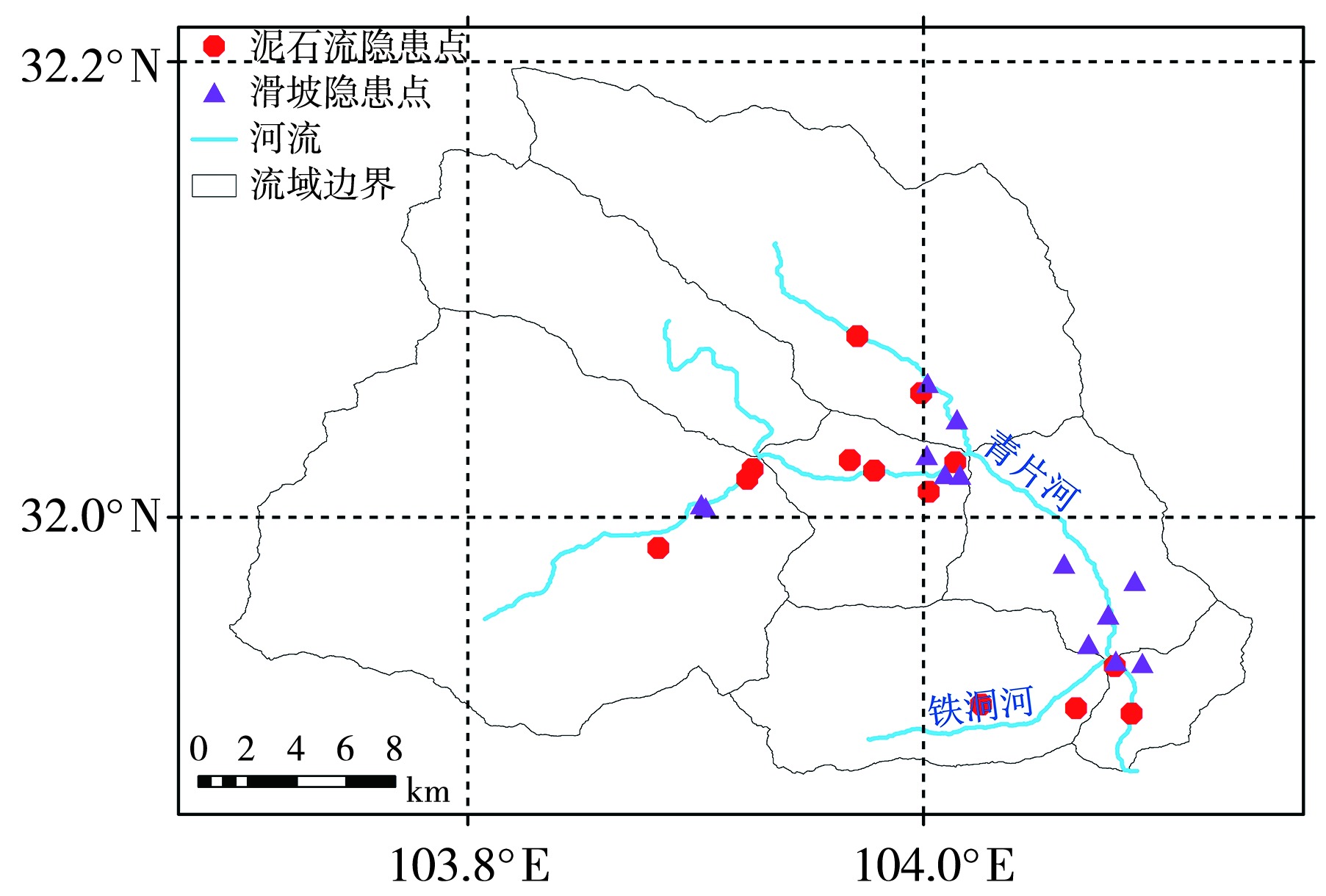
摘要: 基于分布式降雨径流汇流模型,采用分钟级雷达定量降雨估测数据和12.5 m分辨率地形数据,并利用双溪水文站的实测数据进行模型参数本地化,对2022年7月16日绵阳市北川县白什乡的山洪泥石流进行精细化模拟,回溯其径流形成与汇流过程,并分析灾害成因。结果表明,本地化后的径流汇流模型在水深模拟方面与实测数据拟合度较高,确定性系数R2达0.86,最大水深误差为0.25 m,水深涨幅误差为0.59 m,产流时间误差为0.1 h,均在可接受范围内,为后期模拟与分析奠定良好基础。2022年7月16日00:00(北京时)起,北川县持续降雨8.0 h,降雨强度达大暴雨等级。降雨中心位于白什乡灾害点及其上游的青片河和铁洞河流域,大雨及以上降水覆盖整个流域的70%,暴雨更是遍及中下游区域。流域内最大小时雨量达30 mm,最大累计雨量120 mm,中下游区域平均面雨量为88 mm。降雨持续时间长、强度高、覆盖范围广,是此次山洪的主要诱因。此外,流域地形落差大、河道狭窄,持续性暴雨加剧水流速度并推高河道水深,多个点位水流速度超过3.3 m·s-1;青片河下游水深持续上涨2.0 h,洪峰水深达15.4 m并持续2.6 h,为下游灾害点提供了主要径流;白什乡灾害点的洪峰水深高达21.0 m并在高位持续3.0 h。复杂地形条件下的持续性暴雨导致小流域发生大规模山洪,造成河道沿岸多个村落不同程度被淹没。研究区位于龙门山断裂带中心,是“5·12”汶川大地震的重灾区,区域内泥石流和滑坡隐患点多达23处。特大山洪剧烈冲刷泥石流物源引发山洪泥石流,对白什乡场镇造成毁灭性破坏。

关键词: 小流域山洪, N-S方程, 径流汇流模型, 成因分析

Abstract:

This study employs a distributed rainfall-runoff routing model, using minute-resolution radar quantitative precipitation estimation data and 12.5 m-resolution topographic data. Model parameters were calibrated using observed data from the Shuangxi Hydrological Station. A refined simulation was conducted to reproduce the flash flood and debris flow event that occurred in Baishi Township, Beichuan County, Mianyang City, Sichuan Province, on July 16, 2022. The model effectively retraced the runoff generation and confluence processes and analyzed the underlying causes of the disaster. Results show that the localized model performed well, with a high degree of consistency between simulated and observed water depths. The coefficient of determination (R2) reached 0.86, with a maximum water depth error of 0.25 m, a rise magnitude error of 0.59 m, and a runoff onset timing error of 0.1 h, all within acceptable margins and laying a solid foundation for subsequent analyses. From 00:00 Beijing time on July 16, 2022, Beichuan experienced 8.0 hours of continuous rainfall reaching rainstorm levels. The heaviest precipitation occurred in Baishi Township and the upstream basins of the Qingpian and Tiedong rivers, with rainstorms covering 70% of the total basin area and particularly affecting the middle and lower reaches. The maximum hourly rainfall reached 30 mm, the maximum cumulative rainfall was 120 mm, and the average rainfall in the middle and lower reaches was 88 mm. The long duration, high intensity, and wide spatial coverage of rainfall were the primary triggers of the flash flood. In addition, steep terrain gradients and narrow river channels accelerated runoff and increased water depth. Flow velocities at several locations exceeded 3.3 m·s-1. In the lower Qingpian River, water depth continued to rise for 2.0 hours, reaching a flood peak of 15.4 m that lasted for 2.6 hours, contributing significantly to the runoff at the disaster site. At Baishi Township, the peak flood depth reached 21.0 m and remained at a high level for 3.0 hours. Under complex terrain conditions, prolonged heavy rainfall triggered a large-scale flash flood in the small watershed, inundating multiple villages along the river to varying extents. The study area lies within the central Longmenshan Fault Zone and was severely impacted by the 2008 Wenchuan Earthquake. There are 23 identified hazard sites for debris flows and landslides in the basin. The intense flash flood scoured and mobilized abundant loose material, generating a catastrophic debris flow that caused devastating damage to Baishi Township.

Key words: small watershed flash floods, N-S equation, runoff convergence model, analysis of flash flood causes

中图分类号: