干旱气象 ›› 2022, Vol. 40 ›› Issue (6): 954-967.DOI: 10.11755/j.issn.1006-7639(2022)-06-0954
应用FY卫星产品分析陇东半干旱区特大暴雨事件云特征
李晨蕊1( ), 伏晶1(), 刘维成1, 王基鑫1, 王一丞1, 傅朝1, 郑新2
- 1.兰州中心气象台,甘肃 兰州 730020
2.兰州市气象局,甘肃 兰州 730020
-
收稿日期:2022-09-13修回日期:2022-11-16出版日期:2022-12-31发布日期:2023-01-10 -
通讯作者:伏晶 -
作者简介:李晨蕊(1991—),女,工程师,主要从事卫星遥感与强对流天气研究. E-mail:lcr0273@l26.com。 -
基金资助:甘肃省气象局气象科研项目重点项目(Zd2023-03);干旱气象科学研究基金项目(IAM202114);甘肃省气象局创新团队项目(GSQXCXTD-2020-01)
Cloud characteristics analysis of a torrential rainfall event use FY satellite in semi-arid region of Eastern Gansu Province
LI Chenrui1(), FU Jing1(), LIU Weicheng1, WANG Jixin1, WANG Yicheng1, FU Zhao1, ZHEN Xin2
- 1. Lanzhou Central Meteorological Observatory, Lanzhou 730020, China
2. Lanzhou Meteorological Bureau of Gansu Province, Lanzhou 730020, China
-
Received:2022-09-13Revised:2022-11-16Online:2022-12-31Published:2023-01-10 -
Contact:FU Jing
摘要:
降水与云的发生发展密切相关,研究强对流云特征,对降水机理分析、降水监测和预报具有重要意义。2022年7月15日地处西北半干旱区的甘肃陇东出现一次特大暴雨过程,多站日降水量和小时降水量均突破历史极值,本文基于FY-4A、FY-4B静止卫星扫描成像辐射计(advanced geostationary radiation imager, AGRI)数据,FY-3D极轨卫星微波湿度计(micro-wave humidity sounder, MWHS)和微波温度计(micro-wave temperature sounder, MWTS)融合产品,分析此次特大暴雨事件中云宏微观特征、云系演变特征及大气环境条件。结果表明:(1)暴雨云系的云顶类型为过冷水云、混合云、不透明冰云和多层云等,发生强降水的云顶类型以不透明冰云为主,云顶高度达14 km以上;暴雨云系云体深厚,主要为小粒径冰云且伴有强烈上升气流。(2)此次暴雨事件存在对流云团新生、合并及加强过程,对流云团稳定维持是导致特大暴雨发生的主要原因,降水与云顶相当黑体亮温(black body temperature, TBB)及其变化的关系密切,TBB低值区对应强降水,且强降水发生前TBB迅速下降。(3)强降水发生前大气层结表现出浅层对流不稳定的特征,中低层强烈增湿是对流不稳定发展的主要原因,低层绝对湿度的差异造成了不稳定条件及降水量级的差异。
中图分类号:
引用本文
李晨蕊, 伏晶, 刘维成, 王基鑫, 王一丞, 傅朝, 郑新. 应用FY卫星产品分析陇东半干旱区特大暴雨事件云特征[J]. 干旱气象, 2022, 40(6): 954-967.
LI Chenrui, FU Jing, LIU Weicheng, WANG Jixin, WANG Yicheng, FU Zhao, ZHEN Xin. Cloud characteristics analysis of a torrential rainfall event use FY satellite in semi-arid region of Eastern Gansu Province[J]. Journal of Arid Meteorology, 2022, 40(6): 954-967.
表1 卫星数据简介
Tab.1 Introduction to the satellite data
| 卫星 | 观测要素 | 空间分辨率 /km | 时间分辨率 |
|---|---|---|---|
| FY-4A | 云顶相当黑体亮温、云顶类型、云顶高度和大气水汽含量 | 4 | 15 min~1 h |
| FY-4B | 夜间微物理图像、白天微物理图像和强风暴图像 | 4 | 15 min~1 h |
| FY-3D | 大气温湿度廓线、K指数、抬升指数(lifting index,LI) | 33 | 轨道周期:101.5 min 回归周期:5.5 d |
表1 卫星数据简介
Tab.1 Introduction to the satellite data
| 卫星 | 观测要素 | 空间分辨率 /km | 时间分辨率 |
|---|---|---|---|
| FY-4A | 云顶相当黑体亮温、云顶类型、云顶高度和大气水汽含量 | 4 | 15 min~1 h |
| FY-4B | 夜间微物理图像、白天微物理图像和强风暴图像 | 4 | 15 min~1 h |
| FY-3D | 大气温湿度廓线、K指数、抬升指数(lifting index,LI) | 33 | 轨道周期:101.5 min 回归周期:5.5 d |
表2 FY-4B卫星多通道RGB组合
Tab.2 The multi-channel RGB combination from FY-4B satellite
| 卫星图像 | R | G | B |
|---|---|---|---|
| 夜间微物理图像 | IR 12.0 μm,10.8 μm | IR 10.8 μm,3.72 μm | IR 10.8 μm |
| 白天微物理图像 | WV 6.25 μm,7.1μm | IR 3.72 μm,10.8 μm | NIR 1.61 μm,VIS 0.66 μm |
| 强风暴图像 | VIS 0.83 μm | IR 3.72 μm | IR 10.8 μm |
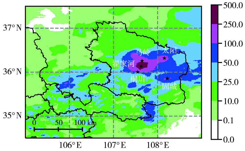
图1 2022年7月14日20:00至15日20:00陇东及其周边地区24 h累计降水量空间分布(单位:mm) (黑色五角星为5个区域站地理位置。下同)
Fig.1 The spatial distribution of 24 h cumulative precipitation from 20:00 BST on 14 to 20:00 BST on 15 July 2022 in Eastern Gansu and its surrounding areas (Unit: mm) (The black pentagram for 5 regional stations geography location. the same as below )
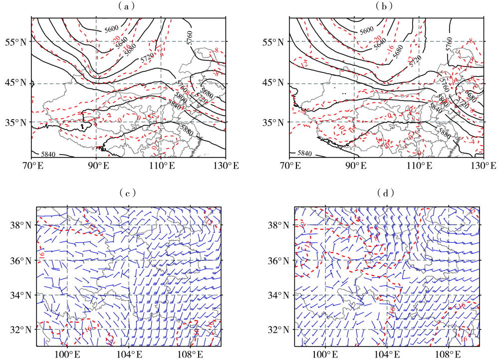
图2 2022年7月15日02:00(a、c)、14:00(b、d)500 hPa位势高度场(黑色等值线,单位:gpm)及温度场(红色等值线,单位:℃)(a、b),700 hPa风场(风矢量,单位:m·s-1)及温度场(红色等值线,单位:℃)(c、d)
Fig.2 The geopotential height field (black isolines, Unit: gpm) and temperature field (red isolines, Unit: ℃) at 500 hPa(a, b),wind field (wind vectors, Unit: m·s-1) and temperature field (red isolines, Unit: ℃) at 700 hPa (c, d) at 02:00 BST (a, c) and 14:00 BST (b, d) on 15 July 2022
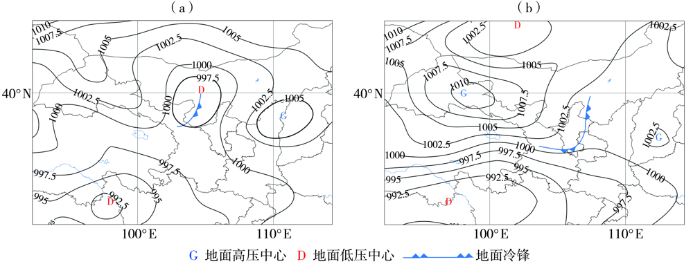
图3 2022年7月15日02:00(a)、14:00(b)海平面气压场(单位:hPa)
Fig.3 Sea-level pressure field (Unit: hPa) at 02:00 BST (a) and 14:00 BST (b) on 15 July 2022
图3 2022年7月15日02:00(a)、14:00(b)海平面气压场(单位:hPa)
Fig.3 Sea-level pressure field (Unit: hPa) at 02:00 BST (a) and 14:00 BST (b) on 15 July 2022

图4 2022年7月15日00:00—17:00 FY-4A卫星云顶类型分布
Fig.4 The distribution of cloud types from FY-4A satellite from 00:00 BST to 17:00 BST on 15 July 2022
图4 2022年7月15日00:00—17:00 FY-4A卫星云顶类型分布
Fig.4 The distribution of cloud types from FY-4A satellite from 00:00 BST to 17:00 BST on 15 July 2022

图5 2022年7月15日05:00(a)、17:00(b)FY-4A卫星云顶高度分布(单位:km)
Fig.5 The distribution of cloud top height from FY-4A satellite at 05:00 BST (a) and 17:00 BST (b) on 15 July 2022 (Unit: km)
图5 2022年7月15日05:00(a)、17:00(b)FY-4A卫星云顶高度分布(单位:km)
Fig.5 The distribution of cloud top height from FY-4A satellite at 05:00 BST (a) and 17:00 BST (b) on 15 July 2022 (Unit: km)
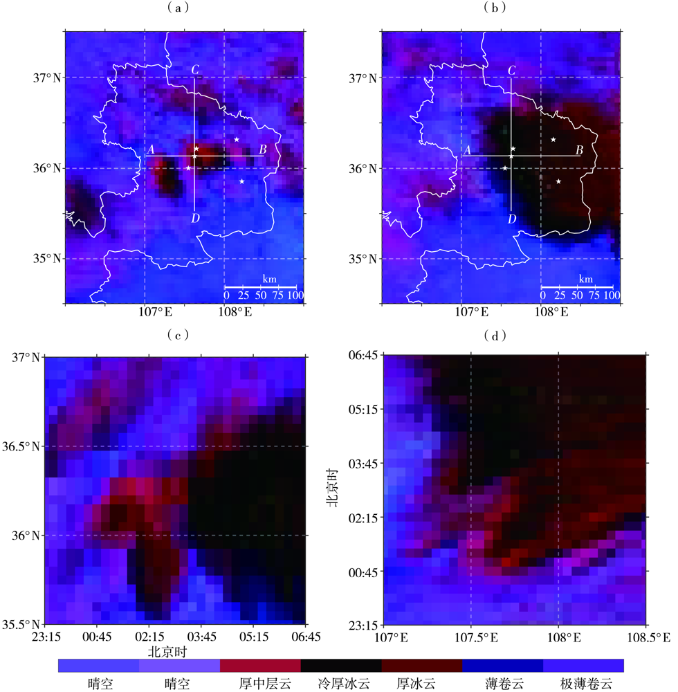
图6 2022年7月15日01:00(a)、05:00(b)FY-4B卫星夜间微物理图像及沿翟家河站(107.62°E,36.08°N)的纬度-时间(c,沿CD线段)和经度-时间(d,沿AB线段)剖面 (白色五角星为5个区域站地理位置)
Fig.6 The microphysical image at nighttime from FY-4B satellite at 01:00 BST (a) and 05:00 BST (b) on 15 July 2022, and the latitude-time (c, along CD line segment) and longitude-time (d, along AB line segment) cross section along Zhaijiahe station (107.62°E, 36.08°N) (The white pentagram for 5 regional stations geography location)
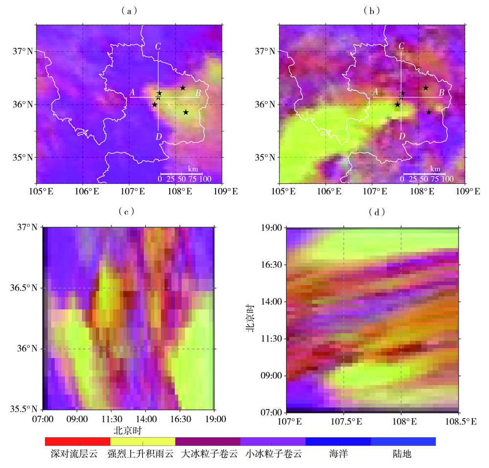
图7 2022年7月15日08:00(a)、16:00(b)FY-4B卫星白天强风暴图像及沿翟家河站(107.62°E,36.08°N)的纬度-时间(c,沿CD线段)和经度-时间(d,沿AB线段)剖面
Fig.7 The storm image on daytime from FY-4B satellite at 08:00 BST (a) and 16:00 BST (b) on 15 July 2022,and the latitude-time (c, along CD line segment) and longitude-time (d, along AB line segment) cross section along Zhaijiahe station (107.62°E,36.08°N)

图8 2022年7月15日14:00(a)、16:00(b)FY-4B卫星白天微物理图像及沿翟家河站(107.62°E,36.08°N)的纬度-时间(c,沿CD线段)和经度-时间(d,沿AB线段)剖面
Fig.8 The microphysical image in the daytime from FY-4B satellite at 14:00 BST (a) and 16:00 BST (b) on 15 July 2022,and the latitude-time (c, along CD line segment) and longitude-time (d, along AB line segment) cross section along Zhaijiahe station (107.62°E,36.08°N)
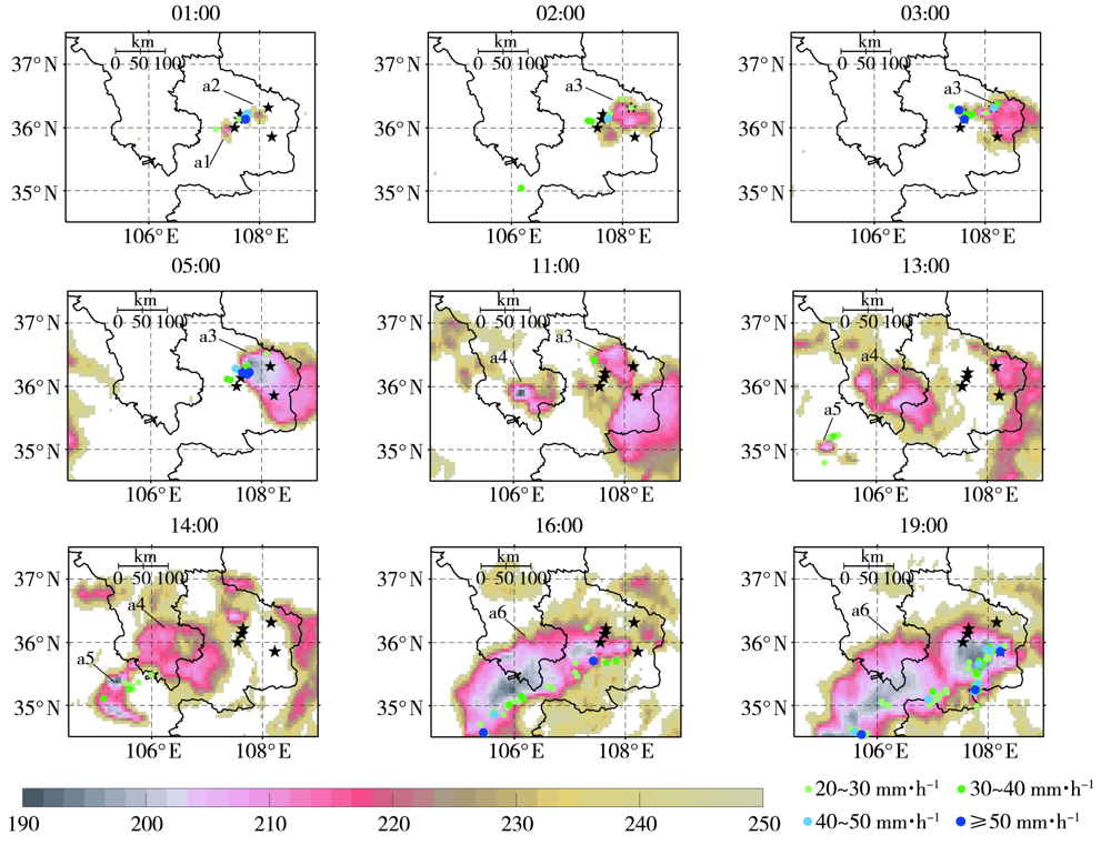
图9 2022年7月15日01:00—19:00 FY-4A卫星TBB分布(彩色填色区,单位:K)及小时雨强(彩色圆点,单位:mm·h-1)
Fig.9 The TBB distribution (color shaded areas, Unit: K) and hourly precipitation intensity (color dots, Unit: mm·h-1)from 01:00 BST to 19:00 BST on 15 July 2022
图9 2022年7月15日01:00—19:00 FY-4A卫星TBB分布(彩色填色区,单位:K)及小时雨强(彩色圆点,单位:mm·h-1)
Fig.9 The TBB distribution (color shaded areas, Unit: K) and hourly precipitation intensity (color dots, Unit: mm·h-1)from 01:00 BST to 19:00 BST on 15 July 2022
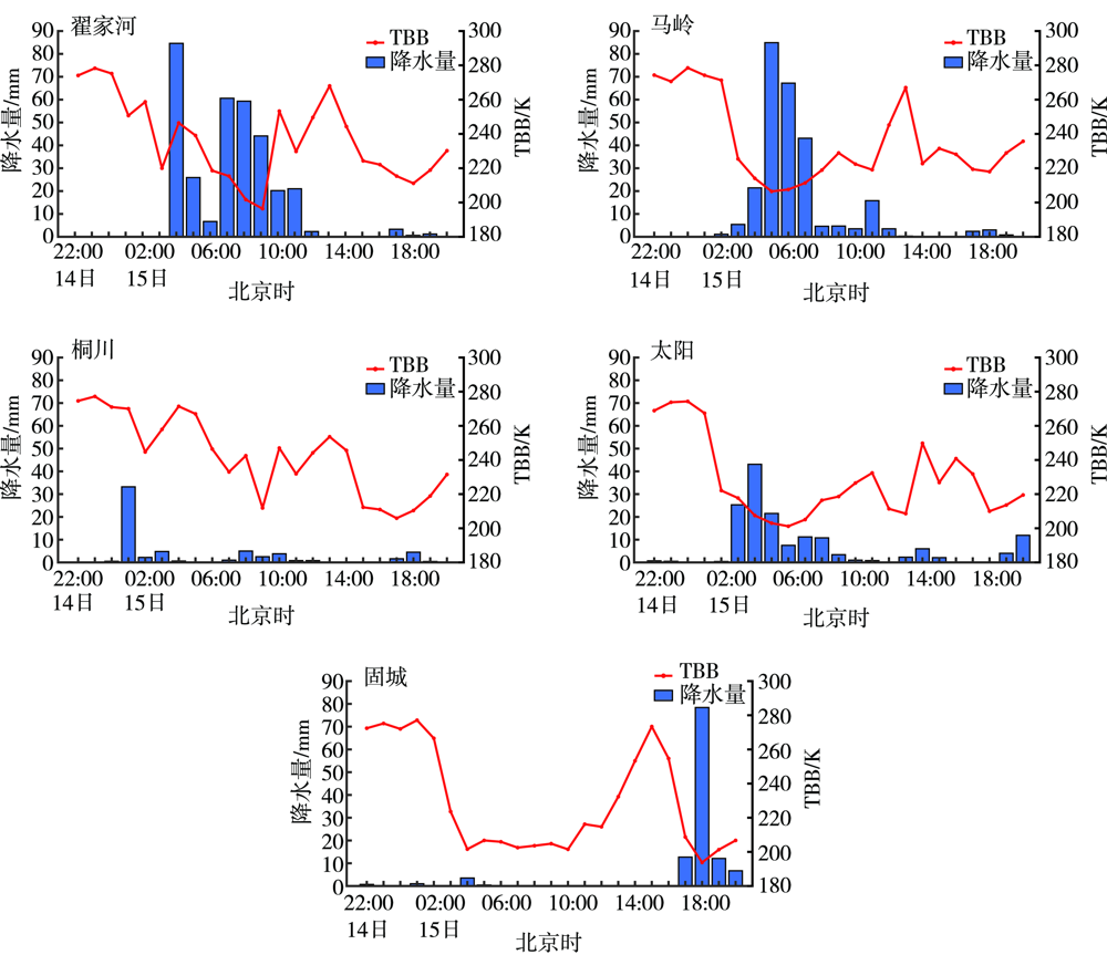
图10 2022年7月14日22:00至15日20:00庆阳不同站点TBB及降水量逐时变化
Fig.10 The hourly variation of TBB and precipitation at different stations in Qingyang from 22:00 BST 14 to 20:00 BST 15 July 2022
图10 2022年7月14日22:00至15日20:00庆阳不同站点TBB及降水量逐时变化
Fig.10 The hourly variation of TBB and precipitation at different stations in Qingyang from 22:00 BST 14 to 20:00 BST 15 July 2022
图11 2022年7月15日01:43 FY-3D卫星获取的K指数(a)、LI(b)
Fig.11 The K index (a) and LI (b) from FY-3D satellite at 01:43 BST on 15 July 2022
图11 2022年7月15日01:43 FY-3D卫星获取的K指数(a)、LI(b)
Fig.11 The K index (a) and LI (b) from FY-3D satellite at 01:43 BST on 15 July 2022

图12 2022年7月15日01:43 FY-3D卫星反演温度(a)、比湿(b)及假相当位温(c)垂直廓线
Fig.12 The vertical profile of temperature (a) and specific humidity (b) retrieved by FY-3D satellite and pseudo potential temperature vertical profile (c) at 01:43 BST on 15 July 2022
图12 2022年7月15日01:43 FY-3D卫星反演温度(a)、比湿(b)及假相当位温(c)垂直廓线
Fig.12 The vertical profile of temperature (a) and specific humidity (b) retrieved by FY-3D satellite and pseudo potential temperature vertical profile (c) at 01:43 BST on 15 July 2022
| [1] | 刘健, 张文建, 朱元竞, 等. 中尺度强暴雨云团云特征的多种卫星资料综合分析[J]. 应用气象学报, 2007, 18(2):158-164. |
| [2] | 杨磊, 才奎志, 孙丽, 等. 基于葵花8号卫星资料的沈阳两次暴雨过程中对流云特征对比分析[J]. 暴雨灾害, 2020, 39(2):125-135. |
| [3] | 何锡玉, 蔡夕方, 朱亚平, 等. 我国风云极轨气象卫星及应用进展[J]. 气象科技进展, 2021, 11(1):34-39. |
| [4] |
MADDOX R A. Mesoscale convective complexes[J]. Bulletin of the American Meteorological Society, 1980, 61(11): 1374-1387.
DOI URL |
| [5] |
MECIKALSKI J R, BEDKA K M. Forecasting convective initiation by monitoring the evolution of moving cumulus in daytime GOES imagery[J]. Monthly Weather Review, 2006, 134(1):49-78.
DOI URL |
| [6] | 覃丹宇, 方宗义. 利用静止气象卫星监测初生对流的研究进展[J]. 气象, 2014, 40(1):7-17. |
| [7] | 牛宁, 姜晓飞, 张昕, 等. 风云四号卫星产品在一次暴雨天气过程分析中的应用[J]. 卫星应用, 2022, 3:42-48. |
| [8] | 王清平, 秦贺, 程海艳, 等. 天山北坡中部一次短时暴雨的卫星反演云参数特征及成因分析[J]. 干旱区地理, 2021, 44(6):1580-1589. |
| [9] | 张夕迪, 孙军. 葵花8号卫星在暴雨对流云团监测中的应用分析[J]. 气象, 2018, 44(10):1245-1254. |
| [10] | 高梦醒, 肖天贵. 基于卫星云图对四川盆地东北部“9·13”暴雨特征分析[J]. 成都信息工程大学学报, 2016, 31(1):102-109. |
| [11] | 张琪, 任景轩, 肖递祥, 等. “5·6”四川盆地对流云团特征及触发机制[J]. 气象, 2017, 43(12): 1487-1495. |
| [12] | 吴涛, 张家国, 牛奔. 一次强降水过程涡旋状MCS结构特征及成因初步分析[J]. 气象, 2017, 43(5):540-551. |
| [13] |
朱平, 肖建设. 青海高原短时强降水天气的葵花-8卫星监测预警特征对比分析[J]. 高原气象, 2022, 41(2):502-514.
DOI |
| [14] | 张晓茹, 李映春, 纪晓玲, 等. 基于葵花-8卫星宁夏暴雨监测预警指标研究[J]. 沙漠与绿洲气象, 2022, 16(1):41-47. |
| [15] | 张晓茹, 陈豫英, 姚姗姗, 等. 贺兰山东麓一次局地强对流暴雨的中尺度特征[J]. 气象, 2022, 48(7):801-812. |
| [16] |
张雅乐, 俞小鼎. 黄河气旋暴雨过程发展演变成因分析[J]. 高原气象, 2021, 40(1):74-84.
DOI |
| [17] | 吴志彦, 李宏江, 赵海军, 等. 卫星水汽图像和位势涡度场在一次变性台风暴雨过程中的解译应用[J]. 气象与环境学报, 2018, 34(3):1-8. |
| [18] | 周鑫, 周顺武, 覃丹宇, 等. 利用FY-2F快速扫描资料分析对流初生阶段的云顶物理量特征[J]. 气象, 2019, 45(2):216-227 |
| [19] |
沈程锋, 李国平. 基于GPM资料的四川盆地及周边地区夏季地形降水垂直结构研究[J]. 高原气象, 2022, 41(6):1532-1543.
DOI |
| [20] | 傅云飞, 罗晶, 罗双, 等. GPM卫星DPR和GMI探测的2018年5月重庆超级单体云团降水结构特征分析[J]. 暴雨灾害, 2022, 41(1):1-14. |
| [21] | 李函璐, 孙礼璐, 杨柳, 等. 基于TRMM PR探测资料的青藏高原东坡降水结构特征分析[J]. 暴雨灾害, 2022, 41(4):384-395. |
| [22] | 李芳, 李南, 万瑜. 台风“温比亚”影响山东期间GPM资料的降水分析[J]. 海洋气象学报, 2020, 40(4):69-76. |
| [23] | 向朔育, 李跃清, 闵文彬, 等. 基于CloudSat探测的西南低涡对流云垂直结构特征[J]. 高原山地气象研究, 2019, 39(3):1-6. |
| [24] | 朱梅, 何君涛, 方勉, 等. GPM卫星资料在分析“杜苏芮”台风降水结构中的应用[J]. 干旱气象, 2018, 36(6):997-1002. |
| [25] | 王宝鉴, 黄玉霞, 魏栋, 等. TRMM卫星对青藏高原东坡一次大暴雨强降水结构的研究[J]. 气象学报, 2017, 75(6):966-980. |
| [26] |
蒋璐君, 李国平, 母灵, 等. 基于TRMM资料的西南涡强降水结构分析[J]. 高原气象, 2014, 33(3):607-614.
DOI |
| [27] |
CHANG W Y, LEE W C, LIOU Y U C. The kinematic and microphysical characteristics and associated precipitation efficiency of subtropical convection during SoWMEX/TiMREX[J]. Monthly Weather Review, 2015, 143(1):317-340.
DOI URL |
| [28] |
ZIPSER E J, LUTZ K R. The vertical profile of radar reflectivity of convective cells: a strong indicator of storm intensity and lightning probability?[J]. Monthly Weather Review, 1994, 122(8):1751-1759.
DOI URL |
| [29] | 陆风, 张晓虎, 陈博洋, 等. 风云四号气象卫星成像特性及其应用前景[J]. 海洋气象学报, 2017, 37(2):1-12 |
| [30] | 高大伟, 樊高峰, 胡永亮, 等. FY-3气象卫星微波水汽三维可视化及其在强天气监测中的应用[J]. 国土资源遥感, 2014, 26(1):139-143. |
| [31] |
SHAO J, GAO H, WANG X, et al. Application of Fengyun-4 satellite to flood disaster monitoring through a rapid multi-temporal synthesis approach[J]. Journal of Meteorological Research, 2020, 34(4):720-731.
DOI URL |
| [32] | 张琪, 任景轩, 肖红茹, 等. 基于FY-4A卫星资料的四川盆地MCC初生和成熟阶段特征[J]. 大气科学, 2021, 45(4):863-873. |
| [33] |
束艾青, 许冬梅, 李泓, 等. FY-3D卫星MWHS-2辐射率资料直接同化对台风“米娜”预报的影响[J]. 热带海洋学报, 2022, 41(5):17-28.
DOI |
| [34] | 乔海伟, 张彦丽. 融合FY-3C号和FY-4A号卫星数据的积雪面积变化研究——以祁连山区为例[J]. 遥感技术与应用, 2020, 35(6):1320-1328. |
| [35] |
TAN Z H, MA S, ZHAO X B. et al. Evaluation of cloud top height retrievals from China's next-generation geostationary meteorological satellite FY-4A[J]. Journal of Meteorological Research, 2019, 33(3):553-562.
DOI URL |
| [36] |
WANG T, LUO J, LIANG J, et al. Comparisons of AGRI/FY-4A cloud fraction and cloud top pressure with MODIS/Terra measurements over East Asia[J]. Journal of Meteorological Research, 2019, 33(4):705-719.
DOI URL |
| [37] | 王明, 陈英英, 周毓荃, 等. 基于一次暴雨过程的风云四号A星三种云参数应用效果对比分析[J]. 暴雨灾害, 2022, 41(4):396-404. |
| [38] |
崔林丽, 郭巍, 葛伟强, 等. FY-4A卫星云顶参数精度检验及台风应用研究[J]. 高原气象, 2020, 39(1):196-203.
DOI |
| [39] | 甘肃省气象局. 甘肃省气候图集[M]. 北京: 气象出版社, 2017. |
| [40] | 唐宏渊. 甘肃庆阳市干旱成因及防治对策[J]. 中国防汛抗旱, 2014, 24(6):4-6 |
| [41] | 张洪芬, 李祥科, 焦美玲, 等. 甘肃庆阳2018年暴雨异常偏多特征分析[J]. 气象与环境科学, 2021, 44(3):61-68. |
| [42] | 王雪芹, 徐卫红, 向朔育, 等. 基于FY-4卫星资料分析暴雨云系特征[J]. 高原山地气象研究, 2020, 40(1):36-40. |
| [43] | 衣娜娜, 苏立娟, 郑旭程, 等. 内蒙古西部地区降水云宏观特征[J]. 干旱气象, 2021, 39(3):406-414. |
| [44] | 孙继松, 戴建华, 何力富, 等. 强对流天气预报的基本原理与技术方法:中国强对流天气预报手册[M]. 北京: 气象出版社, 2014:23-24. |
| [45] | DOSWELL C A. A review for forecasters on the application of hodographs to forecasting severe thunderstorms[J]. National Weather Digest, 1991, 16(1):2-16 |
| [46] |
樊李苗, 俞小鼎. 中国短时强对流天气的若干环境参数特征分析[J]. 高原气象, 2013, 32(1): 156-165.
DOI |
| [47] | 高守亭, 周玉淑, 冉令坤. 我国暴雨形成机理及预报方法研究进展[J]. 大气科学, 2018, 42(4):833-846. |
| [48] |
REN S L, JIANG J Y, FANG X, et al. FY-4A/GIIRS temperature validation in winter and application to cold wave monitoring[J]. Journal of Meteorological Research, 2022, 36(4):658-676.
DOI URL |
| [1] | 肖贻青, 马永永, 陈小婷, 安大维, 黄少妮.
陕南汉江盆地一次冷锋触发的短时强降水过程及预报检验
[J]. 干旱气象, 2023, 41(6): 972-983. |
| [2] | 王一丞, 刘维成, 宋兴宇, 张文光.
卫星降水产品在陇东 2022年 7月特大暴雨事件中的适用性评估
[J]. 干旱气象, 2023, 41(6): 997-1007. |
| [3] | 唐永兰, 徐桂荣, 王晓芳, 肖艳姣, 祁海霞, 冷亮. 1992—2021年三峡库区夏季小时强降水时空分布特征[J]. 干旱气象, 2023, 41(4): 589-598. |
| [4] | 马志敏, 王将, 连钰, 张万诚, 牛法宝, 杨素雨. 云南一次强对流暴雨天气学成因分析[J]. 干旱气象, 2023, 41(4): 629-638. |
| [5] | 郭飞燕, 刁秀广, 褚颖佳, 李欣, 陆雪, 张少博. 两次极端强降水风暴双偏振参量特征对比分析[J]. 干旱气象, 2023, 41(1): 103-113. |
| [6] | 张君霞, 黄武斌, 杨秀梅, 刘维成, 周子涵, 沙宏娥. 陇东半干旱区一次特大暴雨事件的降水极端性分析[J]. 干旱气象, 2022, 40(6): 922-932. |
| [7] | 杨丽杰, 曹彦超, 刘维成, 徐丽丽, 张洪芬, 孙子茱. 陇东黄土高原旱区短时强降水的时空分布特征及地形影响研究[J]. 干旱气象, 2022, 40(6): 945-953. |
| [8] | 肖安, 尹小飞, 刘献耀. 江西省降水日变化时空分布特征[J]. 干旱气象, 2022, 40(5): 840-848. |
| [9] | 许敏, 沈芳, 刘淇淇, 李娜, 王洁. 线状MCSs强降水特征及形成条件[J]. 干旱气象, 2022, 40(4): 596-604. |
| [10] | 兰明才, 周莉, 蒋帅, 尹依雯, 许霖. 西太平洋副热带高压控制下湖南一次短时强降水成因分析[J]. 干旱气象, 2022, 40(4): 656-666. |
| [11] | 钟敏, 肖安, 许冠宇. 基于CMA-MESO的分级短时强降水概率预报方法研究[J]. 干旱气象, 2022, 40(4): 700-709. |
| [12] | 沈晓燕, 申燕玲, 权晨, 杜华礼, 颜玉倩. 不同方法对青海2020年强降水模式产品预报性能的检验对比[J]. 干旱气象, 2022, 40(2): 333-343. |
| [13] | 胡振菊, 黎璐, 黄小玉, 何炳文, 叶日新. 一次典型东风波极端暴雨的中尺度特征及地形影响分析[J]. 干旱气象, 2022, 40(1): 73-83. |
| [14] | 李蓉, 刘新伟, 魏栋, 段海霞, 段伯隆, 李嘉睿, 狄潇泓. 基于区域自动站数据的兰州地区降水精细化特征[J]. 干旱气象, 2022, 40(1): 55-61. |
| [15] | 杨振鑫, 祁萍, 孙磊, 崔小平, 赵月兰. 青藏高原东北侧短时强降水阈值确定及特征分析[J]. 干旱气象, 2021, 39(4): 563-568. |
| 阅读次数 | ||||||
|
全文 |
|
|||||
|
摘要 |
|
|||||
