Journal of Arid Meteorology ›› 2025, Vol. 43 ›› Issue (3): 413-423.DOI: 10.11755/j.issn.1006-7639-2025-03-0413
• Articles • Previous Articles Next Articles
Classification and meteorological element evolution of rainstorm in the eastern Helan Mountain foothills
CHEN Min1,2( ), CHEN Yuying1,3(), CHEN Rong1,2, CHEN Yuxi1, YANG Yuanyuan1,2
- 1. Key Laboratory for Meteorological Disaster Monitoring and Early Warning and Risk Management of Characteristic Agriculture in Arid Regions, CMA, Yinchuan 750002, China
2. Yinchuan Meteorological Office of Ningxia, Yinchuan 750002, China
3. Ningxia Key Laboratory of Meteorological Disaster Prevention and Mitigation, Yinchuan 750002, China
-
Received:2024-05-06Revised:2024-11-27Online:2025-06-30Published:2025-07-12
贺兰山东麓暴雨天气分型及气象要素演变特征研究
陈敏1,2(), 陈豫英1,3(), 陈荣1,2, 陈宇曦1, 杨苑媛1,2
- 1.中国气象局旱区特色农业气象灾害监测预警与风险管理重点实验室,宁夏 银川 750002
2.宁夏银川市气象局,宁夏 银川 750002
3.宁夏气象防灾减灾重点实验室,宁夏 银川 750002
-
通讯作者:陈豫英 -
作者简介:陈敏(1995—),女,陕西咸阳人,工程师,主要从事天气预报研究。E-mail: 1459545469@qq.com。 -
基金资助:国家自然科学基金项目(41965001);宁夏重点研发计划项目(2024BEG02034);宁夏自然科学基金项目(2024AAC03414);宁夏智能数字预报技术研究与应用科技创新团队项目(2024CXTD006);宁夏科技创新领军人才项目(2021GKLRLX05);及中国气象局旱区特色农业气象灾害监测预警与风险管理重点实验室青年培养项目(CAMT-202202)
CLC Number:
Cite this article
CHEN Min, CHEN Yuying, CHEN Rong, CHEN Yuxi, YANG Yuanyuan. Classification and meteorological element evolution of rainstorm in the eastern Helan Mountain foothills[J]. Journal of Arid Meteorology, 2025, 43(3): 413-423.
陈敏, 陈豫英, 陈荣, 陈宇曦, 杨苑媛. 贺兰山东麓暴雨天气分型及气象要素演变特征研究[J]. 干旱气象, 2025, 43(3): 413-423.
share this article
Add to citation manager EndNote|Ris|BibTeX
URL: http://www.ghqx.org.cn/EN/10.11755/j.issn.1006-7639-2025-03-0413
Tab.1 Classification and statistical characteristics of 17 rainstorm events in the eastern Helan Mountain foothills from 2016 to 2021
| 过程分类 | 平均持续 时间/h | 平均 雨量/mm | 暴雨平均 站数/个 | 大暴雨平均 站数/个 | 特大暴雨平均 站数/个 | 短时强降水 平均站数/个 | 最大累计 雨量/mm | 最大雨强/(mm·h-1) |
|---|---|---|---|---|---|---|---|---|
| 冷暖交汇型 | 15.3 | 19.0 | 26.4 | 0.7 | 0 | 28.9 | 119.1 | 58.0 |
| 暖区型 | 18.0 | 12.1 | 20.7 | 3.0 | 0.8 | 39.2 | 277.6 | 84.5 |
| 弱冷空气入侵型 | 14.0 | 12.9 | 23.0 | 1.3 | 0 | 36.5 | 136.2 | 54.5 |
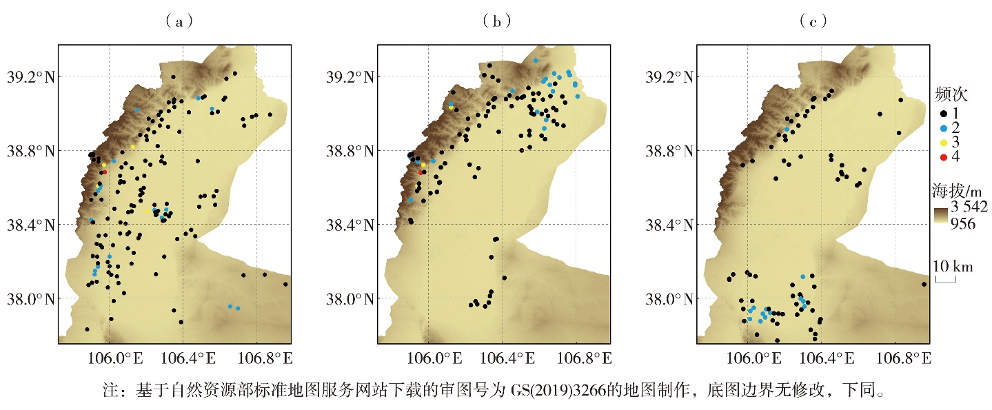
Fig.1 Statistics of rainstorm frequency (Unit: times) for cold-warm air convergence type (a), warm-sector type (b), and weak cold air intrusion type (c)
Fig.1 Statistics of rainstorm frequency (Unit: times) for cold-warm air convergence type (a), warm-sector type (b), and weak cold air intrusion type (c)
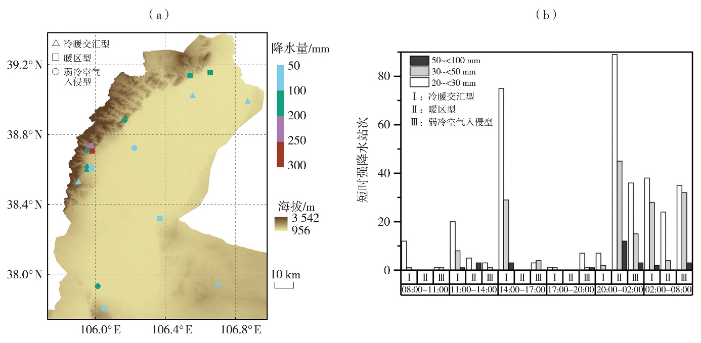
Fig.2 Rainstorm centers (a) and station counts of short-time heavy rainstorm by time period (b) of three types of rainstorm in the eastern foothills of Helan Mountain from 2016 to 2021
Fig.2 Rainstorm centers (a) and station counts of short-time heavy rainstorm by time period (b) of three types of rainstorm in the eastern foothills of Helan Mountain from 2016 to 2021
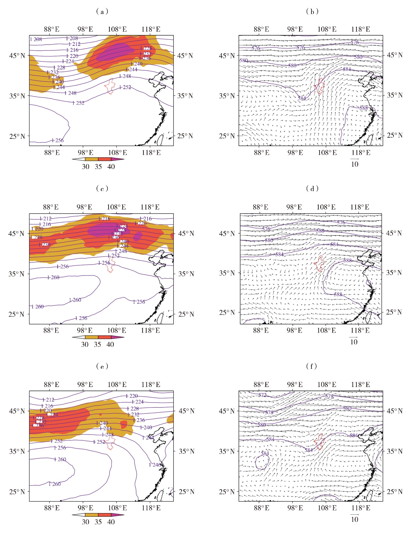
Fig.3 The average geopotential height field (contours, Unit: dagpm) and jet flow area with wind speed greater than or equal to 30 m·s-1 (the color shaded) at 200 hPa (a, c, e) and the average geopotential height field (contours, Unit: dagpm) and wind field (wind vectors, Unit: m·s-1) at 500 hPa (b, d, f) of rainstorm for cold-warm convergence type (a, b), warm-sector type (c, d), and weak cold air intrusion type (e, f) (The red line range indicates Ningxia, the same as below)
Fig.3 The average geopotential height field (contours, Unit: dagpm) and jet flow area with wind speed greater than or equal to 30 m·s-1 (the color shaded) at 200 hPa (a, c, e) and the average geopotential height field (contours, Unit: dagpm) and wind field (wind vectors, Unit: m·s-1) at 500 hPa (b, d, f) of rainstorm for cold-warm convergence type (a, b), warm-sector type (c, d), and weak cold air intrusion type (e, f) (The red line range indicates Ningxia, the same as below)

Fig.4 The composite wind field (vector arrows, Unit: m·s-1), relative humidity field (the green shadow, Unit: %) and water vapor flux greater than 8×10⁵ g·hPa·cm-1·s-1 (blue isolines, Unit: 105 g·hPa·cm-1·s-1) at 700 hPa (a, c, e) and 850 hPa (b, d, f) of rainstorm for cold-warm convergence type (a, b), warm-sector type (c, d), and weak cold air intrusion type (e, f)
Fig.4 The composite wind field (vector arrows, Unit: m·s-1), relative humidity field (the green shadow, Unit: %) and water vapor flux greater than 8×10⁵ g·hPa·cm-1·s-1 (blue isolines, Unit: 105 g·hPa·cm-1·s-1) at 700 hPa (a, c, e) and 850 hPa (b, d, f) of rainstorm for cold-warm convergence type (a, b), warm-sector type (c, d), and weak cold air intrusion type (e, f)
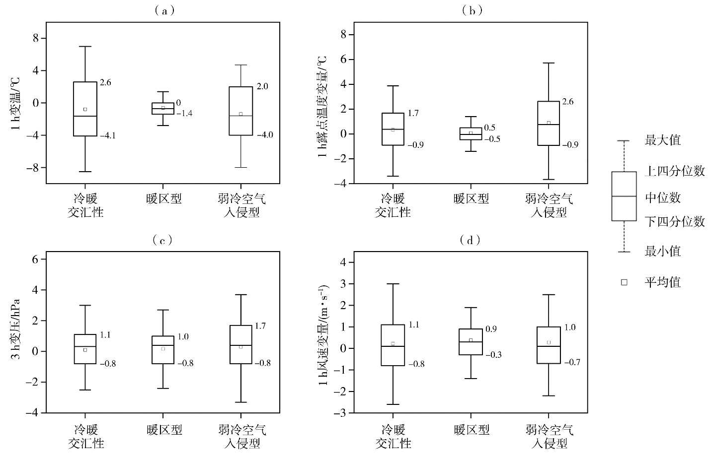
Fig.5 Box plots of 1-hour temperature change (a), 1-hour dew point temperature variation (b), 3-hour pressure change (c) and 1-hour wind speed variation (d) at the onset of rainstorm for cold-warm air convergence type, warm-sector type, and weak cold air intrusion type
Fig.5 Box plots of 1-hour temperature change (a), 1-hour dew point temperature variation (b), 3-hour pressure change (c) and 1-hour wind speed variation (d) at the onset of rainstorm for cold-warm air convergence type, warm-sector type, and weak cold air intrusion type
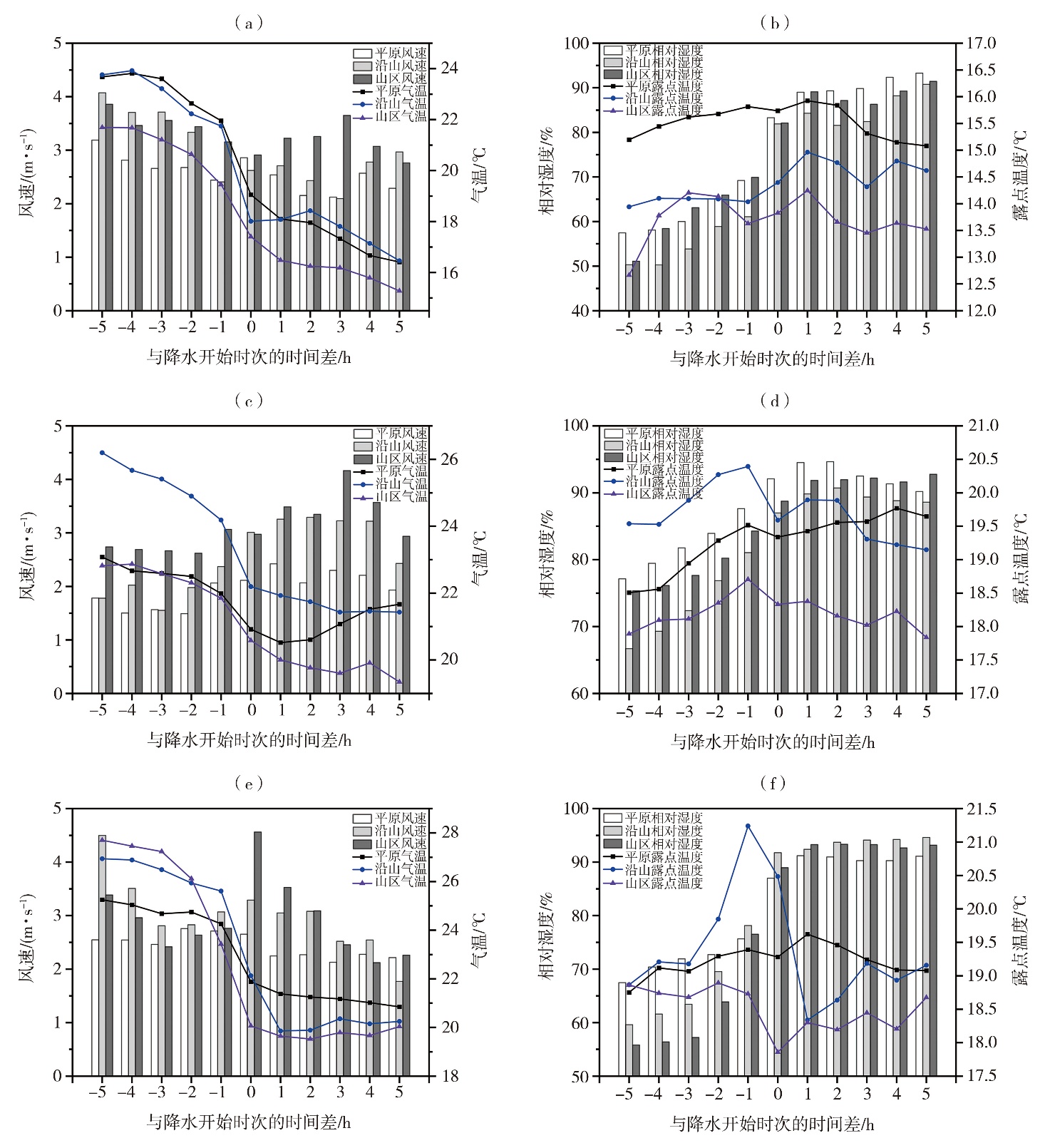
Fig.6 The variation of average wind speed, temperature (a, c, e), and relative humidity and dew point temperature (b, d, f) before and after the onset of rainstorm for different station types of cold-warm air convergence type (a, b), warm-sector type (c, d) and weak cold air intrusion type (e, f)
Fig.6 The variation of average wind speed, temperature (a, c, e), and relative humidity and dew point temperature (b, d, f) before and after the onset of rainstorm for different station types of cold-warm air convergence type (a, b), warm-sector type (c, d) and weak cold air intrusion type (e, f)
Tab. 2 Statistics of variation index with surface meteorological elements in different rainstorm types
| 暴雨类型 | 变温 | 变湿 | 变压 | 风速变化 | 露点温度变化 |
|---|---|---|---|---|---|
| 冷暖交汇型 | 前4 h降温6 ℃且前1 h降温2 ℃ | 前1 h增幅10% 且湿度≥90% | 3 h变幅-4.0~-1.0 hPa | 前1 h降温0.8~1.0 ℃ | |
| 暖区型 | 前5 h降温2~4 ℃ | 前1 h增幅5%~8%且湿度≥90% | 3 h变幅0.2~3.1 hPa | 前3 h增大3~4 m·s-1 | 前1 h降温0.8~1.0 ℃ |
| 弱冷空气 侵入型 | 前2 h降温4~6 ℃ | 前1 h增幅12%且湿度≥90% | 3 h变幅-2.5~3.2 hPa | 前3 h增大2 m·s-1 | 前1 h降温0.8~3.5 ℃ |
Tab. 3 Comparison of inspection results of surface meteorological element indexes in 17 rainstorm events 单位:%
| 暴雨类型 | TS评分 | 空报率 | 漏报率 | 变温达标率 | 变湿达标率 | 变压达标率 | 变风达标率 | 露点温度变化达标率 |
|---|---|---|---|---|---|---|---|---|
| 暖区型 | 48.65 | 40.32 | 27.53 | 35.35 | 57.77 | 53.43 | 30.97 | 53.58 |
| 冷暖交汇型 | 45.98 | 43.77 | 28.39 | 49.65 | 56.36 | 63.21 | 32.54 | 55.24 |
| 弱冷空气侵入型 | 41.37 | 45.67 | 36.56 | 42.44 | 51.16 | 47.92 | 26.24 | 50.47 |
| [1] | 曹怡清, 隆霄, 李超, 等, 2022. 低空急流对贺兰山东麓两次暴雨影响的数值模拟研究[J]. 干旱区研究, 39(6):1739-1 752. |
| [2] | 陈鹏, 庞玥, 张虹, 等, 2017. 台风与冷空气对重庆“9.17”大暴雨的影响分析[J]. 暴雨灾害, 36(3):227-234. |
| [3] | 陈涛, 陈博宇, 于超, 等, 2020. 华南前汛期锋面对流系统和暖区对流系统的多尺度特征和集合预报敏感性对比分析[J]. 气象, 46(9):1129-1 142. |
| [4] | 陈豫英, 陈楠, 任小芳, 等, 2018. 贺兰山东麓罕见特大暴雨的预报偏差和可预报性分析[J]. 气象, 44(1):159-169. |
| [5] |
陈豫英, 苏洋, 杨银, 等, 2021. 贺兰山东麓极端暴雨的中尺度特征[J]. 高原气象, 40(1):47-60.
DOI |
| [6] | 黄士松, 1986. 华南前汛期暴雨[M]. 广州: 广东科技出版社. |
| [7] | 李超, 隆霄, 曹怡清, 等, 2022. 贺兰山东麓20次暴雨过程环流形势及低空急流特征[J]. 干旱区研究, 39(6):1753-1 767. |
| [8] | 李晓虹, 苏占胜, 纳丽, 等, 2021. 贺兰山东麓暴雨气候特征及灾害防御对策[J]. 干旱区地理, 44(5):1231-1 239. |
| [9] | 梁钰, 邵宇翔, 席世平, 等, 2010. 一次弱环境场下的郑州局地暴雨预报难点分析[J]. 气象与环境科学, 33(3):23-28. |
| [10] | 全国气候与气候变化标准化技术委员会, 2017. 暴雨灾害等级:GB/T 33680—2017[S]. 北京: 中国标准出版社. |
| [11] | 邵建, 何劲夫, 陈敏, 等, 2024. 基于FY-4A卫星数据的短时强降水监测预警指标[J]. 气象科技, 52(1):141-150. |
| [12] |
邵建, 闫军, 裴晓蓉, 等, 2018. 自组织神经网络算法在宁夏暴雨天气分型中的应用[J]. 干旱气象, 36(5):852-857.
DOI |
| [13] |
沈晓玲, 潘灵杰, 左骏, 等, 2022. 浙江西部梅汛期两次相似落区暴雨过程对比分析[J]. 干旱气象, 40(2):244-255.
DOI |
| [14] | 寿绍文, 2019. 中国暴雨的天气学研究进展[J]. 暴雨灾害, 38(5):450-463. |
| [15] | 苏洋, 陈豫英, 杨侃, 等, 2023. 低空急流与贺兰山东麓暴雨过程的相关性研究[J]. 气象, 49(10):1171-1 186. |
| [16] | 陶诗言, 1980. 中国之暴雨[M]. 北京: 科学出版社. |
| [17] | 王璐璐, 贾浩松, 刘静, 2023. 一次由边界层冷空气引发的豫南对流性暴雨成因分析[J]. 暴雨灾害, 42(2):134-143. |
| [18] | 王孝慈, 李双君, 孟英杰, 2021. 2016—2020年6—7月长江流域主要暴雨过程特征及差异性分析[J]. 干旱气象, 39(6):921-929. |
| [19] | 《西北暴雨》编写组, 1992. 西北暴雨[M]. 北京: 气象出版社. |
| [20] | 杨侃, 纪晓玲, 毛璐, 等, 2020. 贺兰山两次特大致洪暴雨的数值模拟与地形影响对比[J]. 干旱气象, 38(4):581-590. |
| [21] | 俞小鼎, 2013. 短时强降水临近预报的思路与方法[J]. 暴雨灾害, 32(3):202-209. |
| [22] | 张晓惠, 倪允琪, 2009. 华南前汛期锋面对流系统与暖区对流系统的个例分析与对比研究[J]. 气象学报, 67(1):108-121. |
| [23] | 张晓茹, 陈豫英, 姚姗姗, 等, 2022. 贺兰山东麓一次局地强对流暴雨的中尺度特征[J]. 气象, 48(7):801-812. |
| [24] | CHEN Y Y, LI J P, LI X, et al, 2021. Spatio-temporal distribution of the rainstorm in the east side of the Helan Mountain and the possible causes of its variability[J]. Atmospheric Research, 252: 105469. DOI: 10.1016/j.atmosres. 2021.105469. |
| [1] | SHEN Jiaojiao, HAO Sujuan, JIN Lina, ZHANG Yabin, FAN Dandan, GUO Qi. Impact of urbanization on the climate environment in Xi’an over the past 60 years [J]. Journal of Arid Meteorology, 2025, 43(3): 403-412. |
| [2] | LIN Hongjie, WEN Xiaohang, HUANG Xiaolu, LI Ruiqing. Numerical simulation study of Typhoon “Ambi” degeneration mechanism and its impact on heavy rainstorm in Inner Mongolia [J]. Journal of Arid Meteorology, 2024, 42(4): 588-597. |
| [3] | PAN Liujie, LIANG Mian, QI Chunjuan, LI Peirong, ZHU Qingliang. Characteristics of meteorological elements and objective forecast verification at the key venues of “the 14th National Games” [J]. Journal of Arid Meteorology, 2023, 41(3): 491-502. |
| [4] | CHEN Rong, WANG Jianying, YANG Wenjun, CHEN Min, WANG Qian, LI Kun. Influence factors of atmospheric boundary layer inversion in Yinchuan City and the relation with PM2.5 in winter [J]. Journal of Arid Meteorology, 2023, 41(1): 123-131. |
| [5] | FENG Yao, Ayixianmu·niyazi, Reyila·yunusi. Cause Analysis of an Extreme Heavy Rainstorm Process on July 31 of 2018 in Hami of Xinjiang [J]. Journal of Arid Meteorology, 2021, 39(3): 426-435. |
| [6] | QI Yajie, CHEN Min, ZHONG Jiqin, FAN Shuiyong, LIU Ruiting, GUO Chunwei. Effect Evaluation of Short-term Forecast of Surface Meteorological Elements by Using RMAPS-ST Coupled Urban Canopy Model in North China [J]. Journal of Arid Meteorology, 2020, 38(5): 859-868. |
| [7] | TAN Changrong1, GUO Xiaoning, CHEN Qi, LI Jinhai,YOU Sangjie, MA Xuelian, MA Yuancang, QI Caihong. Study on Surface Ozone Characteristics and Its Influencing Factors in Xining [J]. Journal of Arid Meteorology, 2019, 37(1): 31-39. |
| [8] | ZHANG Guilian, ZHONG Xia, HAN Jingwei, ZHAO Fei,BAO Fuxiang, LI Ruiqing. Analysis on Characteristics of an Extreme Rainstorm Event in the Midwest of Inner Mongolia [J]. Journal of Arid Meteorology, 2018, 36(1): 17-26. |
| [9] | . Variation Characteristic of Main Meteorological Elements During Summer Sand-Dust Storm Processes in East of Hexi Corridor [J]. Journal of Arid Meteorology, 2017, 35(3): 427-. |
| [10] | WANG Jianpeng, XUE Chunfang, HUANG Shaoni,WANG Dan, PAN Liujie, CHENG Lu. Sensitivity Test of Impact of Urbanization and Anthropogenic Heat on Meteorological Elements in Xi’an [J]. Journal of Arid Meteorology, 2015, 33(3): 434-443. |
| [11] | HU Yuling,WANG Suichan,WANG Shigong,SHANG Kezheng,NING Guicai,KANG Caiyan. Analysis of a Rare Regional Heavy Rainstorm Weather Process in Early Summer in Northwest Arid Area in 2012 [J]. Journal of Arid Meteorology, 2015, 33(1): 128-137. |
| [12] | LIU Yong, GUO Damei, HU Qiyuan. Cause Analysis of an Extremely Heavy Rainstorm in Jiaxian County in the North Shaanxi Province on July 27 2012 [J]. Journal of Arid Meteorology, 2014, 32(3): 424-430. |
| [13] | ZHANG Jianming,ZHANG Xinping,CAI Xiufeng,ZHANG Qingyun. Analysis of the Heavy Rainstorm Process on May 13,of 2010 in Central of Hu’nan Province [J]. Journal of Arid Meteorology, 2013, 31(1): 117-125. |
| [14] | . Numerical Simulation and Diagnostic Analysis of a Heavy Rain Occurred in Jiuquan of Gansu Province [J]. Journal of Arid Meteorology, 2012, 30(1): 100-106. |
| [15] | . Change Character of Weather Elements at Tazhong of Xinjiang [J]. Journal of Arid Meteorology, 2011, 29(3): 315-321. |
| Viewed | ||||||
|
Full text |
|
|||||
|
Abstract |
|
|||||