Journal of Arid Meteorology ›› 2024, Vol. 42 ›› Issue (4): 637-648.DOI: 10.11755/j.issn.1006-7639(2024)-04-0637
• Review • Previous Articles Next Articles
Progress of satellite remote sensing inversion method for soil moisture
ZHONG Xue1,2( ), YANG Minglong1,2(), TANG Xiujuan3, HAN Aoxi1,2
- 1. School of Land Resources Engineering Kunming University of Science and Technology, Kunming 650093, China
2. Application Engineering Research Center of Spatial Information Surveying and Mapping Technology in Plateau and Mountainous Areas Set by Universities in Yunnan Province, Kunming 650093, China
3. Kunming Surveying and Mapping Institute, Kunming 650091, China
-
Received:2023-10-25Revised:2024-04-21Online:2024-08-31Published:2024-09-13
土壤水分卫星遥感反演方法研究进展
钟雪1,2(), 杨明龙1,2(), 唐秀娟3, 韩澳禧1,2
- 1.昆明理工大学国土资源工程学院,云南 昆明 650093
2.云南省高校高原山区空间信息测绘技术应用工程研究中心,云南 昆明 650093
3.昆明市测绘研究院,云南 昆明 650091
-
通讯作者:杨明龙(1982—),男,贵州岑巩人,博士,副教授,主要从事资源环境与遥感研究。E-mail:yangml3000@qq.com 。 -
作者简介:钟雪(1997—),女,云南红河人,硕士生,主要从事GIS与遥感应用研究。E-mail: 2226763632@qq.com。 -
基金资助:国家自然科学基金项目(41861054);国家自然科学基金项目(62266026)
CLC Number:
Cite this article
ZHONG Xue, YANG Minglong, TANG Xiujuan, HAN Aoxi. Progress of satellite remote sensing inversion method for soil moisture[J]. Journal of Arid Meteorology, 2024, 42(4): 637-648.
钟雪, 杨明龙, 唐秀娟, 韩澳禧. 土壤水分卫星遥感反演方法研究进展[J]. 干旱气象, 2024, 42(4): 637-648.
share this article
Add to citation manager EndNote|Ris|BibTeX
URL: http://www.ghqx.org.cn/EN/10.11755/j.issn.1006-7639(2024)-04-0637
Tab.1 Optical satellite data
| 数据 | 卫星名称 | 时间分辨率/d | 空间分辨率/m | 波段 | 时间序列 |
|---|---|---|---|---|---|
| AVHRR | NOAA 15 | 1~2 | 1 100 | 5 | 1998年至今 |
| NOAA 19 | 2009—2011年 | ||||
| MetOp-A | 2006年至今 | ||||
| MetOp-B | 2012年至今 | ||||
| MetOp-C | 2018年至今 | ||||
| ASTER | Terra | 15 | 15/30/90 | 14 | 1999年至今 |
| MODIS | Terra | 1 | 500/100 | 36 | 1999年至今 |
| Aqua | 2002年至今 | ||||
| Landsat | Landsat5 | 16 | 30/60 | 7 | 1984—2013年 |
| Landsat8 | 16 | 15/30/100 | 11 | 2013年至今 | |
| Sentinel-2 | Sentinel-2A | 10 | 10/60 | 12 | 2015年至今 |
| Sentinel-2B | 2017年至今 |
Tab.2 Microwave remote sensing data
| 传感器 | 卫星 | 时间分辨率/d | 空间分辨率 | 波段类型 | 时间序列 |
|---|---|---|---|---|---|
| ASCAT | MetOp-A/B/C | 3 | 12~25 km | C波段(主动) | 2007年至今 |
| AMSR-E | Aqua | 2 | 25 km | 多波段(被动) | 2002年至今 |
| AMSR-2 | GCOM WI | 2 | 25 km | 多波段(被动) | 2012年至今 |
| SMOS | SMOS | 1~3 | 35 km | L波段(被动) | 2010年至今 |
| SMAP | SMAP | 3 | 3~40 km | L波段(主被动) | 2015年至今 |
| MWRI | FY-3 | 1~3 | 25 km | 多波段(被动) | 2013年至今 |
| SAR | Sentinel-1 | 6 | 5×20 m | C波段(主动) | 2014年至今 |
| SAR | GF-3 | 2~3 | 1~500 m | C波段(主动) | 2016年至今 |
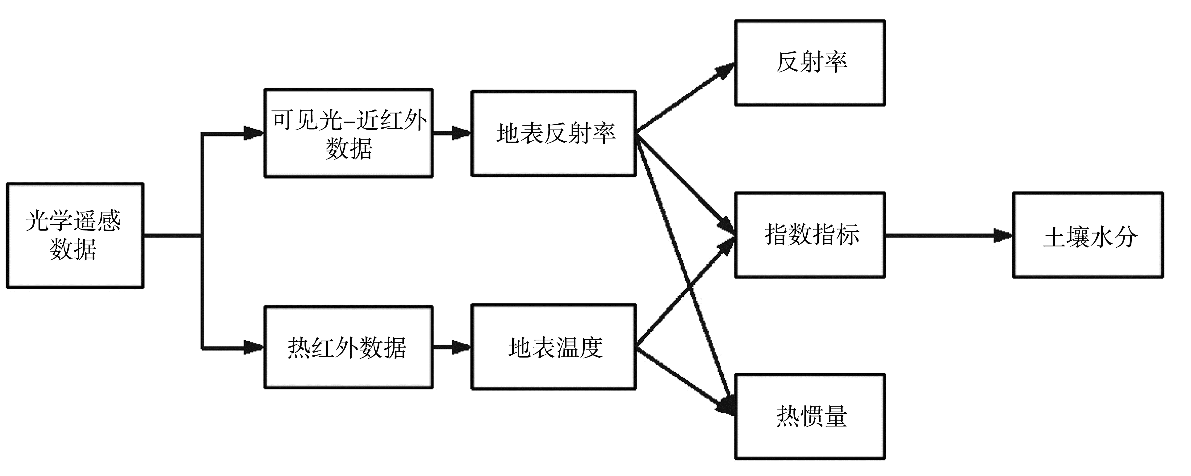
Fig.1 Schematic of the optical data inversion(Qin et al., 2021a)
Fig.1 Schematic of the optical data inversion(Qin et al., 2021a)
Tab.3 Comparison of the optical data inversion methods
| 方法 | 使用数据类型 | 反演使用参数 | 优点 | 缺点 |
|---|---|---|---|---|
| 反射率法 | 可见光-近红外 | 地表反射率 | 算法简单,适用于裸土区 | 反演精度低,偏经验化 |
| 指数法 | 可见光-近红外和热红外 | 植被指数或缺水指数 | 适用于植被覆盖区域 | 具有滞后性,仅描述土壤水分相对状态 |
| 热惯量法 | 可见光-近红外和热红外 | 土壤热惯量 | 适用于裸土区 | 需要大量辅助数据、计算复杂 |
Tab.3 Comparison of the optical data inversion methods
| 方法 | 使用数据类型 | 反演使用参数 | 优点 | 缺点 |
|---|---|---|---|---|
| 反射率法 | 可见光-近红外 | 地表反射率 | 算法简单,适用于裸土区 | 反演精度低,偏经验化 |
| 指数法 | 可见光-近红外和热红外 | 植被指数或缺水指数 | 适用于植被覆盖区域 | 具有滞后性,仅描述土壤水分相对状态 |
| 热惯量法 | 可见光-近红外和热红外 | 土壤热惯量 | 适用于裸土区 | 需要大量辅助数据、计算复杂 |
Tab.4 Soil moisture characteristic index
| 指数名称 | 计算公式 | 适用条件 | 文献 |
|---|---|---|---|
| 归一化植被指数 | 仅适用于定性土壤水分监测 | (潘宁等, | |
| 作物水分胁迫指数 | 适用于植被覆盖区反演 | (Jackson et al., | |
| 植被供水指数 | 适用于植被覆盖密度大的区域反演 | (Moranet al., | |
| 植被条件指数 | 适用于植被区,但需要较长时序数据 | (Kogan, | |
| 距平植被指数 | 适用于植被区,但需要较长时序数据 | (陈维英等, | |
| 温度植被干旱指数 | 适用于植被区,但对植被覆盖要求高 | (Sandholt et al., | |
| 垂直干旱指数 | 适用于裸土区 | (Ghulam et al., | |
| 改进垂直干旱指数 | 适用于植被区,需大量辅助数据 | (Pohn et al., |
Tab.5 Active microwave soil moisture inversion method
| 方法 | 原理 | 优点 | 缺点 | 文献 |
|---|---|---|---|---|
| 经验法 | 统计学数值拟合 | 反演过程简单;辅助数据需求较少;局部区域应用价值高 | 精确度较低;普适性较差 | (Cognard et al., |
| 理论建模法 | 电磁波散射分析理论 | 输入参数具有很强的逻辑性,反演机理明确;适用性较强 | 输入参数多;机理模拟本身存在理想 假设 | (Stogryn, |
| 半经验法 | 理论建模和数值拟合 | 输入参数相对较少;稳定性好 | 缺乏时空普适性,需要根据研究区变化再次拟合 | (Oh et al., |
| 人工智能法 | 智能算法训练 | 可行性较强;计算效率高 | 对于训练样本要求较高、物理机理薄弱 | (Oh, |
Tab.6 Passive microwave soil water inversion method
| 方法 | 原理 | 优势 | 劣势 | 文献 |
|---|---|---|---|---|
| 统计拟合法 | 统计学数值拟合 | 计算简单;局部应用价值较高 | 精度提升困难、缺乏机理分析、缺乏普适性 | (Wang et al., |
| 机理模拟法 | 基于辐射传输过程模拟确定土壤水分与亮温的函数关系 | 理论成熟;改进方向较为明确;反演精度较高;普适性较强 | 包含较多理想性假设;需要一定的辅助数据;需要先验条件且较为费时 | (Zhao et al., |
| 人工智能法 | 智能算法训练 | 较之机理模拟,计算效率高、费时少;拟合效果更好和反演精度高 | 物理基础薄弱、依赖训练样本选取,但良好训练样本获取较为困难 | (Zhao et al., |
| [1] | 陈维英, 肖乾广, 盛永伟, 1994. 距平植被指数在1992年特大干旱监测中的应用[J]. 环境遥感(2): 106-112. |
| [2] | 樊磊, 2017. 基于多源数据的土壤水分估算及森林火灾风险评估应用[D]. 北京: 中国科学院大学. |
| [3] | 方西瑶, 蒋玲梅, 崔慧珍, 2022. 基于Sentinel-1雷达数据的青藏高原地区土壤水分反演研究[J]. 遥感技术与应用, 37(6): 1 447-1 459. |
| [4] | 巩文军, 郭乙霏, 王文婷, 等, 2019. 基于混合象元分解的Landsat8与MODIS数据融合反演土壤墒情方法研究[J]. 灌溉排水学报, 38(7): 123-128. |
| [5] | 关韵桐, 2019. 基于SAR与光学数据的高原湿地土壤水分反演研究——以大山包湿地为例[D]. 昆明: 云南师范大学. |
| [6] | 郭交, 刘健, 宁纪锋, 等, 2019. 基于Sentinel多源数据的农田地表土壤水分反演模型构建与验证[J]. 农业工程学报, 35(14): 71-78. |
| [7] | 姜传礼, 赵健赟, 丁圆圆, 等, 2023. SPA算法与机器学习的黄河源土壤水分反演[J]. 光谱学与光谱分析, 43(6): 1 961-1 967. |
| [8] | 雷志斌, 孟庆岩, 田淑芳, 等, 2019. 基于GF-3和Landsat8遥感数据的土壤水分反演研究[J]. 地球信息科学学报, 21(12): 1 965-1 976. |
| [9] | 李伯祥, 陈晓勇, 徐雯婷, 2019. 基于水云模型的Sentinel-1A双极化反演植被覆盖区土壤水分[J]. 水土保持研究, 26(5): 39-44. |
| [10] |
李忆平, 李耀辉, 2017. 气象干旱指数在中国的适应性研究进展[J]. 干旱气象, 35(5): 709-723.
DOI |
| [11] | 刘帆, 申双和, 杨炳玉, 等, 2013. 不同土壤水分条件下玉米叶片/冠层气孔导度的光谱监测模型[J]. 中国农业气象, 34(6): 727-732. |
| [12] | 刘培君, 张琳, 艾里西尔·库尔班, 等, 1997. 卫星遥感估测土壤水分的一种方法[J]. 遥感学报, 1(2): 135-138. |
| [13] | 刘伟东, FRÉDÉRIC BARET, 张兵, 等, 2004. 高光谱遥感土壤湿度信息提取研究[J]. 土壤学报, 41(5): 700-706. |
| [14] | 马春芽, 王景雷, 黄修桥, 2018. 遥感监测土壤水分研究进展[J]. 节水灌溉(5): 70-74. |
| [15] | 马红章, 刘素美, 彭爱华, 等, 2016. L波段主被动微波协同反演裸土土壤水分[J]. 农业工程学报, 32(19): 133-138. |
| [16] | 孟祥金, 毛克彪, 孟飞, 等, 2019. 基于空间权重分解的降尺度土壤水分产品的中国土壤水分时空格局研究[J]. 高技术通讯, 29(4): 402-412. |
| [17] | 潘宁, 王帅, 刘焱序, 等, 2019. 土壤水分遥感反演研究进展[J]. 生态学报, 39(13): 4 615-4 626. |
| [18] | 覃湘栋, 庞治国, 江威, 2021a. 土壤水分光学遥感反演方法研究进展和挑战[J]. 人民珠江, 42(11):38-45. |
| [19] | 覃湘栋, 庞治国, 江威, 等, 2021b. 土壤水分微波反演方法进展和发展趋势[J]. 地球信息科学学报, 23(10): 1 728-1 742. |
| [20] | 宋扬, 房世波, 梁瀚月, 等, 2017. 基于MODIS数据的农业干旱遥感指数对比和应用[J]. 国土资源遥感, 29(2): 215-220. |
| [21] | 苏永荣, 宫阿都, 吕潇然, 等, 2015. 基于改进温度植被干旱指数的农田土壤水分反演方法[J]. 遥感信息, 30(6): 96-101. |
| [22] | 孙波, 梁勇, 汉牟田, 等, 2019. 基于GA-SVM的GNSS-IR土壤湿度反演方法[J]. 北京航空航天大学学报, 45(3): 486-492. |
| [23] | 王川, 2020. 联合光学和微波遥感数据反演根河林区火烧迹地土壤含水量[D]. 北京: 北京林业大学. |
| [24] | 王俊霞, 潘耀忠, 朱秀芳, 等, 2019. 土壤水分反演特征变量研究综述[J]. 土壤学报, 56(1): 23-35. |
| [25] | 王美林, 姜群鸥, 邵雅琪, 等, 2019. 基于TVDI的玛曲土壤湿度时空变化及其影响因素[J]. 中国水土保持科学, 17(4): 141-152. |
| [26] | 王雅婷, 孔金玲, 杨亮彦, 等, 2019. 基于SVR的旱区稀疏植被覆盖下土壤水分遥感反演[J]. 地球信息科学学报, 21(8): 1 275-1 283. |
| [27] |
王莺, 张强, 王劲松, 等, 2022. 21世纪以来干旱研究的若干新进展与展望[J]. 干旱气象, 40(4): 549-566.
DOI |
| [28] | 魏祖帅, 2019. 青藏高原地区SMAP土壤水分降尺度方法研究[D]. 武汉: 武汉大学. |
| [29] | 吴茜, 2017. 主被动微波协同反演植被覆盖地表土壤水分方法研究[D]. 泰安: 山东农业大学. |
| [30] | 吴善玉, 2019. 基于神经网络算法的多源遥感联合反演土壤湿度研究[D]. 南京: 南京信息工程大学. |
| [31] | 武晓波, 阎守邕, 田国良, 等, 1998. 在GIS支持下用NOAA/AVHRR数据进行旱情监测[J]. 遥感学报, 2(4): 280-284. |
| [32] |
杨扬, 王丽娟, 黄小燕, 等, 2023. 基于ERA5-Land产品的黄河流域蒸散时空变化特征[J]. 干旱气象, 41(3): 390-402.
DOI |
| [33] | 姚一飞, 王爽, 张珺锐, 等, 2022. 基于GF-1卫星遥感的河套灌区土壤含水率反演模型研究[J]. 农业机械学报, 53(9): 239-251. |
| [34] | 余凡, 赵英时, 2011. 基于主被动遥感数据融合的土壤水分信息提取[J]. 农业工程学报, 27(6): 187-192. |
| [35] | 岳胜如, 李瑞平, 邹春霞, 等, 2016. 基于多波段MODIS遥感数据的乌审旗土壤含水量监测研究[J]. 水土保持通报, 36(2): 146-150. |
| [36] | 张传波, 李卫国, 王晶, 等, 2022. 波段反射率和植被指数结合的作物生长季农田土壤水分估测[J]. 江苏农业学报, 38(1): 111-118. |
| [37] | 张双成, 鲍琳, 马中民, 等, 2022. 多源哨兵数据解译农田区土壤湿度算法研究[J]. 测绘科学, 47(8): 94-104. |
| [38] | 赵飞飞, 2021. 多源遥感数据协同的贵州石漠化地区土壤水分反演研究[D]. 贵阳: 贵州大学. |
| [39] | 周鹏, 丁建丽, 王飞, 等, 2010. 植被覆盖地表土壤水分遥感反演[J]. 遥感学报, 14(5): 959-973. |
| [40] | 周雨石, 2018. 基于改进热惯量模型土壤含水量时空变化研究—以黑河上游八宝河流域为例[D]. 开封: 河南大学. |
| [41] | ATTEMA E P, ULABY F T, 1978. Vegetable modeled as a water cloud[J]. Radio Science, 13(2): 357-364. |
| [42] | BOWERS S A, HANKS R J, 1965. Reflection of radiant energy from soils[J]. Soil Science, 100(2): 130-138. |
| [43] | COGNARD A L, LOUMAGNE C, NORMAND M, et al, 1995. Evaluation of the ERS 1/synthetic aperture radar capacity to estimate surface soil moisture: Two‐year results over the naizin watershed[J]. Water Resources Research, 31(4): 975-982. |
| [44] | DOBSON M C, ULABY F T, 1986. Preliminaly evaluation of the SIR-B response to soil moisture, surface roughness, and crop canopy cover[J]. IEEE Transactions on Geoscience and Remote Sensing, GE-24(4): 517-526. |
| [45] | DUBOIS P C, VAN ZYL J, ENGMAN T, 1995. Measuring soil moisture with imaging radars[J]. IEEE Transactions on Geoscience and Remote Sensing, 33(4): 915-926. |
| [46] | EBRAHIMI E, BAYAT H, NEYSHABURI M R, et al, 2014. Prediction capability of different soil water retention curve models using artificial neural networks[J]. Archives of Agronomy and Soil Science, 60(6): 859-879. |
| [47] | EHRLER W L, 1973. Cotton leaf temperatures as related to soil water depletion and meteorological factors[J]. Agronomy Journal, 65(3): 404-409. |
| [48] | EL HAJJ M, BAGHDADI N, ZRIBI M, et al, 2016. Soil moisture retrieval over irrigated grassland using X-band SAR data[J]. Remote Sensing of Environment, 176: 202-218. |
| [49] | FEIZIASL V, FOTOVAT A, ASTARAEI A, et al, 2014. Determination of soil and plant water balance and its critical stages for rainfed wheat using Crop Water Stress Index (CWSI)[J]. Journal of Water and Soil, 28(4): 804-817. |
| [50] | FUJII H, KOIKE T, IMAOKA K, 2009. Improvement of the AMSR-E algorithm for soil moisture estimation by introducing a fractional vegetation coverage dataset derived from MODIS data[J]. Journal of the Remote Sensing Society of Japan, 29(1): 282-292. |
| [51] | GHULAM A, QIN Q M, TEYIP T, et al, 2007a. Modified perpendicular drought index (MPDI): A real-time drought monitoring method[J]. ISPRS Journal of Photogrammetry and Remote Sensing, 62(2): 150-164. |
| [52] | GHULAM A, QIN Q M, ZHAN Z M, 2007b. Designing of the perpendicular drought index[J]. Environmental Geology, 52(6): 1 045-1 052. |
| [53] | GRILLAKIS M G, KOUTROULIS A G, ALEXAKIS D D, et al, 2021. Regionalizing root-zone soil moisture estimates from ESA CCI soil water index using machine learning and information on soil, vegetation, and climate[J]. Water Resources Research, 57(5), DOI: 10.1029/2020WR029249. |
| [54] | JACKSON R D, IDSO S B, REGINATO R J, et al, 1981. Canopy temperature as a crop water stress indicator[J]. Water Resources Research, 17(4): 1 133-1 138. |
| [55] | KARTHIKEYAN L, PAN M, KONINGS A G, et al, 2019. Simultaneous retrieval of global scale vegetation optical depth, surface roughness, and soil moisture using X-band AMSR-E observations[J]. Remote Sensing of Environment, 234, DOI: 10.1016/j.rse.2019.111473. |
| [56] | KOGAN F N, 1990. Remote sensing of weather impacts on vegetation in non-homogeneous areas[J]. International Journal of Remote Sensing, 11(8): 1 405-1 419. |
| [57] | LENG P, LI Z L, LIAO Q Y, et al, 2019. Determination of all-sky surface soil moisture at fine spatial resolution synergistically using optical/thermal infrared and microwave measurements[J]. Journal of Hydrology, 579, DOI: 10.1016/j.jhydrol.2019.124167. |
| [58] | LIEVENS H, REICHLE R H, LIU Q, et al, 2017. Joint Sentinel-1 and SMAP data assimilation to improve soil moisture estimates[J]. Geophysical Research Letters, 44(12): 6 145-6 153. |
| [59] | LIOU Y A, LIU S F, WANG W J, 2001. Retrieving soil moisture from simulated brightness temperatures by a neural network[J]. IEEE Transactions on Geoscience and Remote Sensing, 39(8): 1 662-1 672. |
| [60] | MENG Q Y, XIE Q X, WANG C M, et al, 2016. A fusion approach of the improved Dubois model and best canopy water retrieval models to retrieve soil moisture through all maize growth stages from Radarsat-2 and Landsat-8 data[J]. Environmental Earth Sciences, 75(20), 1377. DOI:10.1007/s12665-016-6182-4. |
| [61] | MERLIN O, AL BITAR A, WALKER J P, et al, 2009. A sequential model for disaggregating near-surface soil moisture observations using multi-resolution thermal sensors[J]. Remote Sensing of Environment, 113(10): 2 275-2 284. |
| [62] | MORAN M S, CLARKE T R, INOUE Y, et al, 1994. Estimating crop water deficit using the relation between surface-air temperature and spectral vegetation index[J]. Remote Sensing of Environment, 49(3): 246-263. |
| [63] | OH Y, 2006. Robust inversion technique for retrieving soil moisture from multi-polarised backscatter of bare surface[J]. Electronics Letters, 42(7): 414-415. |
| [64] | OH Y, SARABANDI K, ULABY F T, 1994. An inversion algorithm for retrieving soil moisture and surface roughness from polarimetric radar observation[C]// Proceedings of IGARSS ʼ94-1994 IEEE International Geoscience and Remote Sensing Symposium. Pasadena, CA, USA. IEEE, 1 582-1 584. DOI: 10.1109/IGARSS.1994.399504. |
| [65] | OH Y, SARABANDI K, ULABY F T, 1992. An empirical model and an inversion technique for radar scattering from bare soil surfaces[J]. IEEE Transactions on Geoscience and Remote Sensing, 30(2):370-381. |
| [66] | POHN H A, OFFIELD T W, WATSON K, 1974. Thermal inertia mapping from satellite-discrimination of geology unit in Oman[J]. Journal of Research of the U.S. Geological Survey, 2(2): 147-158. |
| [67] | PRICE J C, 1985. On the analysis of thermal infrared imagery: The limited utility of apparent thermal inertia[J]. Remote Sensing of Environment, 18(1): 59-73. |
| [68] | SADEGHI M, JONES S B, PHILPOT W D, 2015. A linear physically-based model for remote sensing of soil moisture using short wave infrared bands[J]. Remote Sensing of Environment, 164: 66-76. |
| [69] | SANDHOLT I, RASMUSSEN K, ANDERSEN J, 2002. A simple interpretation of the surface temperature/vegetation index space for assessment of surface moisture status[J]. Remote Sensing of Environment, 79(2/3): 213-224. |
| [70] | SHUKLA J, MINTZ Y, 1982. Influence of land-surface evapotranspiration on the earthʼs climate[J]. Science, 215(4539): 1 498-1 501. |
| [71] | SREEDEEP S, RESHMA A C, SINGH D N, 2004. Measuring soil electrical resistivity using a resistivity box and a resistivity probe[J]. Geotechnical Testing Journal, 27(4): 411-415. |
| [72] | SRIVASTAVA P K, HAN D W, RAMIREZ M R, et al, 2013. Machine learning techniques for downscaling SMOS satellite soil moisture using MODIS land surface temperature for hydrological application[J]. Water Resources Management, 27(8): 3 127-3 144. |
| [73] | STOGRYN A, 1967. Electromagnetic scattering from rough, finitely conducting surfaces[J]. Radio Science, 2(4): 415-428. |
| [74] | TAO L L, WANG G J, CHEN X, et al, 2019. Soil moisture retrieval using modified particle swarm optimization and back-propagation neural network[J]. Photogrammetric Engineering and Remote Sensing, 85(11): 789-798. |
| [75] | TONG C, WANG H Q, MAGAGI R, et al, 2020. Soil moisture retrievals by combining passive microwave and optical data[J]. Remote Sensing, 12(19). DOI: 10.3390/rs12193173. |
| [76] | ULABY F T, SARABANDI K, MCDONALD K, et al, 1990. Michigan microwave canopy scattering model[J]. International Journal of Remote Sensing, 11(7): 1 223-1 253. |
| [77] | WANG J R, MCMURTREY J E III, ENGMAN E T, et al, 1982. Radiometric measurements over bare and vegetated fields at 1.4-GHz and 5-GHz frequencies[J]. Remote Sensing of Environment, 12(4): 295-311. |
| [78] | WEI Z S, MENG Y Z, ZHANG W, et al, 2019. Downscaling SMAP soil moisture estimation with gradient boosting decision tree regression over the Tibetan Plateau[J]. Remote Sensing of Environment, 225: 30-44. |
| [79] | WEIMANN A, 1998. Inverting a microwave backscattering model by the use of a neural network for the estimation of soil moisture[C]// IGARSS ʼ98. Sensing and Managing the Environment. 1998 IEEE International Geoscience and Remote Sensing. Symposium Proceedings. Seattle, WA, USA. IEEE, 1 837-1 839. DOI: 10.1109/IGARSS.1998.703668. |
| [80] | YEE K, 1966. Numerical solution of initial boundary value problems involving Maxwellʼs equations in isotropic media[J]. IEEE Transactions on Antennas and Propagation, 14(3): 302-307. |
| [81] | ZENG J Y, LI Z, CHEN Q, et al, 2015. Evaluation of remotely sensed and reanalysis soil moisture products over the Tibetan Plateau using in-situ observations[J]. Remote Sensing of Environment, 163: 91-110. |
| [82] | ZENG W Z, XU C, HUANG J S, et al, 2016. Predicting near-surface moisture content of saline soils from near-infrared reflectance spectra with a modified Gaussian model[J]. Soil Science Society of America Journal, 80(6): 1 496-1 506. |
| [83] | ZHAO T J, ZHANG L X, SHI J C, et al, 2011. A physically based statistical methodology for surface soil moisture retrieval in the Tibet Plateau using microwave vegetation indices[J]. Journal of Geophysical Research, 116(D8), D08116. DOI: 10.1029/2010JD015229. |
| [84] | ZHAO W, SÁNCHEZ N, LU H, et al, 2018. A spatial downscaling approach for the SMAP passive surface soil moisture product using random forest regression[J]. Journal of Hydrology, 563: 1 009-1 024. |
| [1] | QIU Jinjing, CHEN Feng, DONG Meiying, FAN Yuemin, YU Zhenshou. Research on improvement of temperature forecasts of the regional numerical prediction system using CLDAS land data [J]. Journal of Arid Meteorology, 2024, 42(2): 238-250. |
| [2] | SHA Sha, WANG Lijuan, WANG Xiaoping, HU Die, ZHANG Liang. Study on monitoring method of agricultural drought in Gansu Province based on Temperature Vegetation Dryness Index [J]. Journal of Arid Meteorology, 2024, 42(1): 27-38. |
| [3] | WEI Sentao, WANG Chenghai, ZHANG Feimin, YANG Kai. Study of soil moisture prediction method based on soil temperature and moisture persistence [J]. Journal of Arid Meteorology, 2023, 41(5): 783-791. |
| [4] | QI Yue, ZHANG Qiang, HU Shujuan, WANG Runyuan, YANG Yang, LEI Jun, WANG Heling, ZHAO Hong, CHU Chao, JIN Rong. Response of photosynthetic parameters to leaf temperature of spring maize under drought stress [J]. Journal of Arid Meteorology, 2023, 41(2): 215-222. |
| [5] | ZHANG Cunhou, CUI Wei, YUE Kun, ZHAO Xinghua, WU Yingjie, SEN Di. Fluctuating response of soil moisture to precipitation in arid and semi-arid areas: a case study of Damao County in desert steppe [J]. Journal of Arid Meteorology, 2023, 41(2): 260-267. |
| [6] | LI Liang, YANG Zesu, HE Hang. Evapotranspiration-precipitation coupling strength response to hydrothermal factors over northern China [J]. Journal of Arid Meteorology, 2022, 40(5): 791-803. |
| [7] | HOU Qiong, MIAO Bailing, WANG Yingshun, DONG Chunli. Effects of Water Stress on Soil Moisture in Semiarid Typical Steppe [J]. Journal of Arid Meteorology, 2020, 38(6): 987-993. |
| [8] | WANG Long, GONG Huili, PAN Yun, MIAO Bailing, YANG Jingjing, CUI Xintong. Retrieval of Soil Moisture in Typical Steppe of Xilinhot Based on Sentinel-1 SAR Data [J]. Journal of Arid Meteorology, 2019, 37(6): 979-986. |
| [9] | HU Die, SHA Sha, WANG Lijuan, WANG Wei. Drought Monitoring Applications of the European Space Agency Climate Change Initiative Soil Moisture Combined Product in Gansu Province [J]. Journal of Arid Meteorology, 2019, 37(4): 517-528. |
| [10] | JING Hua, KANG Xiuli, MA Aiping, WANG Yuzhi, CUI Huanhu, ZHANG Jiancheng. Effect of Different Altitudes on Characteristics of Soil Water and Water Use Efficiency in Wheat Fields [J]. Journal of Arid Meteorology, 2019, 37(4): 656-662. |
| [11] | SUN Xia, FAN Guangzhou, ZHANG Yongli, LAI Xin. Temporal and Spatial Variation Characteristics of Soil Moisture at Different Layers of the Tibetan Plateau in Summer [J]. Journal of Arid Meteorology, 2019, 37(2): 252-261. |
| [12] | LIU Liwei, WEI Dong, WANG Xiaowei, CHENG Shanjun. Multi-data Intercomparison of Soil Moisture over China [J]. Journal of Arid Meteorology, 2019, 37(1): 40-47. |
| [13] | DENG Mingshan, MENG Xianhong, MA Yingsai, AN Yingying. Analysis on Soil Moisture Characteristics of Tibetan Plateau Based on GLDAS [J]. Journal of Arid Meteorology, 2018, 36(4): 595-602. |
| [14] | WANG Haimei, HOU Qiong, FENG Xuyu, YUN Wenli. Effect of Different Magnitude Rainfall Process on Soil Moisture in Typical Grassland of Xilinhot of Inner Mongolia [J]. Journal of Arid Meteorology, 2016, 34(6): 1010-1015. |
| [15] | YAO Jingyu, WANG Guoying, HUANG Jianping, BI Jianrong. Characteristics of Net Carbon Exchange over the Semi-arid Loess Plateau in Northwest China [J]. Journal of Arid Meteorology, 2016, 34(1): 88-95. |
| Viewed | ||||||
|
Full text |
|
|||||
|
Abstract |
|
|||||