Journal of Arid Meteorology ›› 2021, Vol. 39 ›› Issue (06): 930-938.DOI: 10.11755/j.issn.1006-7639(2021)-06-0930
• Articl • Previous Articles Next Articles
Spatial-temporal distribution and influence of disastrous rainstorm in southern Xinjiang during 2010-2019
WEI Yanying1( ), GONG Meiling1, LI Haihua2()
- 1. Bayingolin Mongol Autonomous Prefecture Meteorological Bureau of Xinjiang Uygur Autonomous Region, Korla 841000, Xinjiang, China
2. Xinjiang Meteorological Observatory, Urumqi 830002, China
-
Received:2021-01-05Revised:2021-06-02Online:2021-12-30Published:2021-12-31 -
Contact:LI Haihua
2010—2019年南疆致灾暴雨时空分布及其影响
- 1.新疆巴州气象局,新疆 库尔勒 841000
2.新疆维吾尔自治区气象台,新疆 乌鲁木齐 830002
-
通讯作者:李海花 -
作者简介:魏艳英(1977— ),女,工程师,主要从事应用气象方面工作. E-mail: 1027546316@qq.com。 -
基金资助:新疆气象局科研课题 “近10年南疆暴雨灾害损失评估技术研究”;国家自然科学基金共同资助(41965002)
CLC Number:
Cite this article
WEI Yanying, GONG Meiling, LI Haihua. Spatial-temporal distribution and influence of disastrous rainstorm in southern Xinjiang during 2010-2019[J]. Journal of Arid Meteorology, 2021, 39(06): 930-938.
魏艳英, 龚美玲, 李海花. 2010—2019年南疆致灾暴雨时空分布及其影响[J]. 干旱气象, 2021, 39(06): 930-938.
share this article
Add to citation manager EndNote|Ris|BibTeX
URL: http://www.ghqx.org.cn/EN/10.11755/j.issn.1006-7639(2021)-06-0930
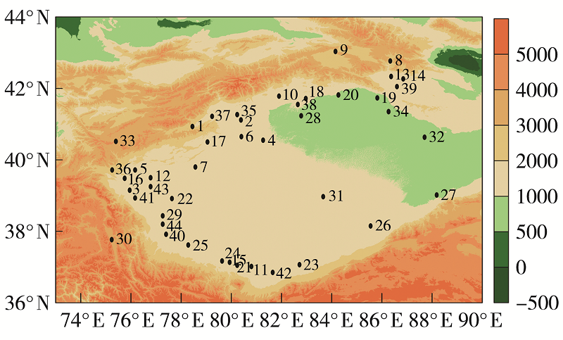
Fig.1 Topography (the shadow, Unit: m) and national meteorological stations (the black dots) distribution in the southern Xinjiang (The numbers are station serial numbers)
Fig.1 Topography (the shadow, Unit: m) and national meteorological stations (the black dots) distribution in the southern Xinjiang (The numbers are station serial numbers)
Tab.1 The station name corresponding to serial number in figure 1
| 地(州) | 站名(序号) |
|---|---|
| 克州 | 阿合奇(1)、阿克陶(2)、阿图什(3)、乌恰(4) |
| 阿克苏 | 阿克苏(5)、阿拉尔(6)、阿瓦提(7)、拜城(8)、柯坪(9)、库车(10)、沙雅(11)、温宿(12)、乌什(13)、新和(14) |
| 巴州 | 巴仑台(15)、巴音布鲁克(16)、和静(17)、和硕(18)、库尔勒(19)、轮台(20)、且末(21)、若羌(22)、塔中(23)、铁干里克(24)、尉犁(25)、焉耆(26) |
| 喀什 | 巴楚(27)、伽师(28)、喀什(29)、麦盖提(30)、莎车(31)、塔什库尔干(32)、吐尔尕特(33)、叶城(34)、英吉沙(35)、岳普湖(36)、泽普(37) |
| 和田 | 策勒(38)、和田(39)、洛浦(40)、民丰(41)、墨玉(42)、皮山(43)、于田(44) |
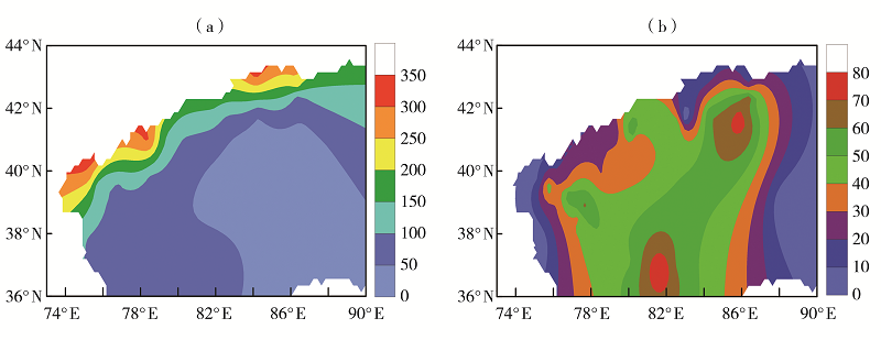
Fig.2 Spatial distribution of annual mean precipitation (a, Unit: mm) and the proportion of annual mean rainstorm precipitation to the total precipitation (b, Unit:%) in the southern Xinjiang during 2010-2019
Fig.2 Spatial distribution of annual mean precipitation (a, Unit: mm) and the proportion of annual mean rainstorm precipitation to the total precipitation (b, Unit:%) in the southern Xinjiang during 2010-2019
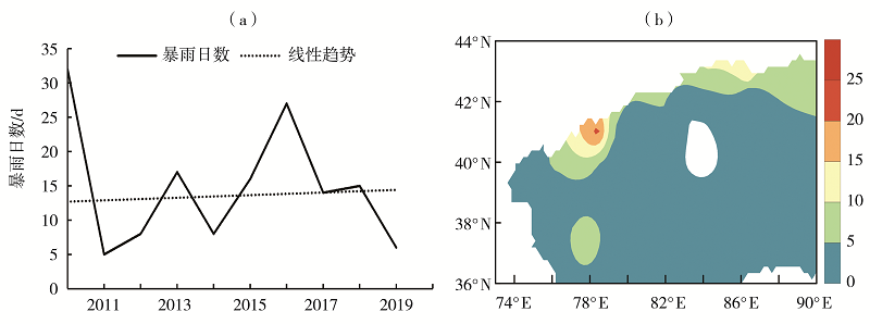
Fig.3 The inter-annual variation (a) and spatial distribution (b) of rainstorm days in the southern Xinjiang from March to October during 2010-2019 (Unit: d)
Fig.3 The inter-annual variation (a) and spatial distribution (b) of rainstorm days in the southern Xinjiang from March to October during 2010-2019 (Unit: d)
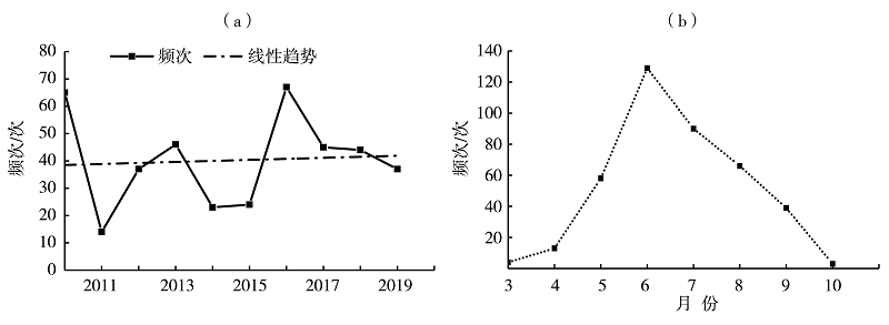
Fig.4 The inter-annual (a) and monthly (b) variation of occurrence frequency of rainstorm and flood disasters in the southern Xinjiang from March to October during 2010-2019
Fig.4 The inter-annual (a) and monthly (b) variation of occurrence frequency of rainstorm and flood disasters in the southern Xinjiang from March to October during 2010-2019
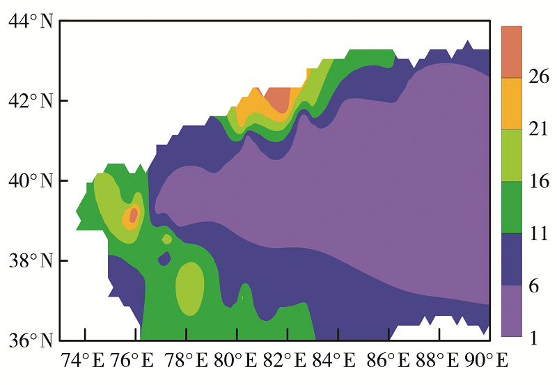
Fig.5 The spatial distribution of occurrence frequency of rainstorm and flood disasters in the southern Xinjiang from March to October during 2010-2019 (Unit: times)
Fig.5 The spatial distribution of occurrence frequency of rainstorm and flood disasters in the southern Xinjiang from March to October during 2010-2019 (Unit: times)
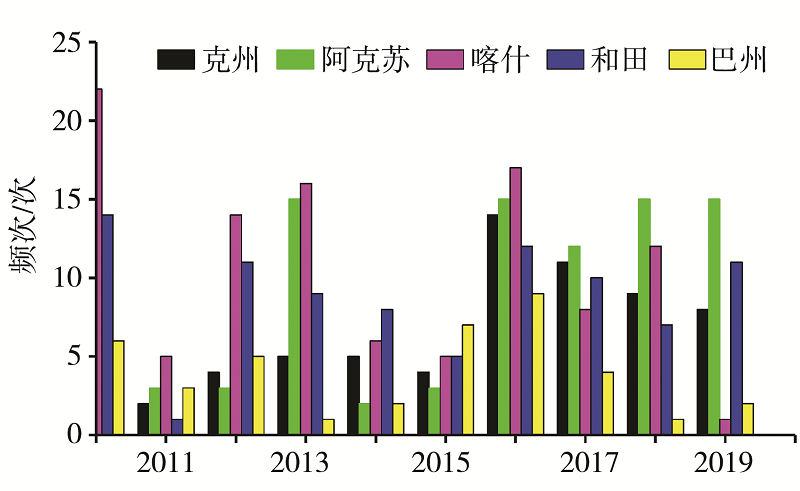
Fig.6 The inter-annual variation of occurrence frequency of rainstorm and flood disasters in different areas of the southern Xinjiang from March to October during 2010-2019
Fig.6 The inter-annual variation of occurrence frequency of rainstorm and flood disasters in different areas of the southern Xinjiang from March to October during 2010-2019
Tab.2 Statistics of rainstorm and flood disasters in different areas of the southern Xinjiang from March to October during 2010-2019
| 地(州) | 受灾人数/ 万人 | 农作物受灾 面积/hm2 | 直接经济 损失/万元 | 农业经济 损失/万元 | 农业经济损失占 直接经济损失的比例/% |
|---|---|---|---|---|---|
| 克州 | 11 | 89 176.3 | 124 317.50 | 82 583.18 | 66.4 |
| 阿克苏 | 168 | 529 044.1 | 1 025 366.00 | 801 391.52 | 78.2 |
| 巴州 | 17 | 302 141.4 | 233 458.40 | 184 181.97 | 78.9 |
| 喀什 | 144 | 189 274.7 | 364 260.60 | 141 985.61 | 39.0 |
| 和田 | 65 | 16 549.8 | 96 099.49 | 5527.08 | 5.8 |
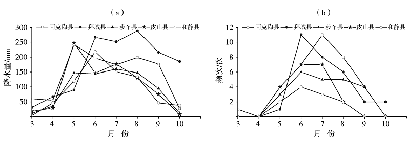
Fig.7 The variation of cumulative precipitation (a) and occurrence frequency of rainstorm and flood disasters (b) in representative counties of the southern Xinjiang from March to October during 2010-2019
Fig.7 The variation of cumulative precipitation (a) and occurrence frequency of rainstorm and flood disasters (b) in representative counties of the southern Xinjiang from March to October during 2010-2019
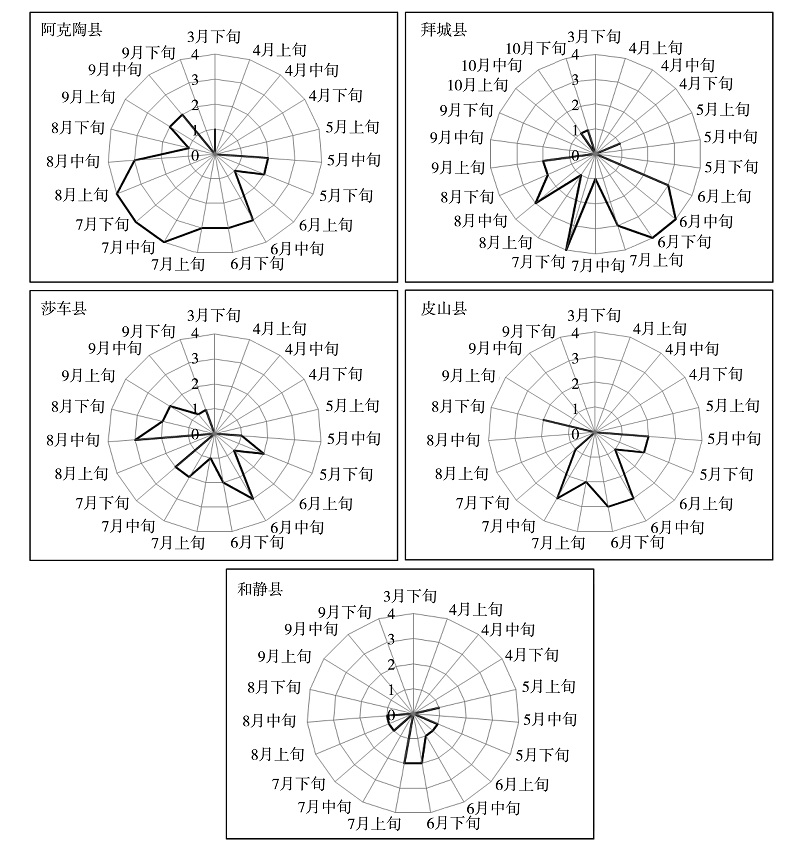
Fig.8 The ten days variation of occurrence frequency of rainstorm and flood disasters in representative counties of the southern Xinjiang from March to October during 2010-2019 (Unit: times)
Fig.8 The ten days variation of occurrence frequency of rainstorm and flood disasters in representative counties of the southern Xinjiang from March to October during 2010-2019 (Unit: times)
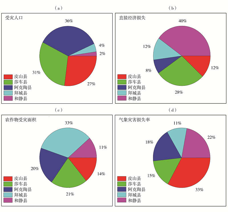
Fig.9 The distribution of proportion of affected population (a), direct economic loss (b), affected area of crops (c) and loss rate of meteorological disasters (d) in representative counties of the southern Xinjiang from March to October during 2010-2019
Fig.9 The distribution of proportion of affected population (a), direct economic loss (b), affected area of crops (c) and loss rate of meteorological disasters (d) in representative counties of the southern Xinjiang from March to October during 2010-2019
| [1] | 王春乙, 娄秀荣, 王建林. 中国农业气象灾害对作物产量的影响[J]. 自然灾害学报, 2007, 16(5):37-43. |
| [2] | 房世波, 阳晶晶, 周广胜. 30年来我国农业气象灾害变化趋势和分布特征[J]. 自然灾害学报, 2011, 20(5):69-73. |
| [3] | 周广胜. 气候变化对中国农业生产影响研究展望[J]. 气象与环境科学, 2015, 38(1):80-94. |
| [4] | 路明浩, 程先富. 洪水灾害风险评价研究综述[J]. 四川环境, 2010, 29(6):127-132. |
| [5] | 周月华, 彭涛, 史瑞琴. 我国暴雨洪涝灾害风险评估研究进展[J]. 暴雨灾害, 2019, 38(5):494-501. |
| [6] |
VISTE E, KORECHA D, SORTEBERG A. Recent drought and precipitation tendencies in Ethiopia[J]. Theoretical and Applied Climatology, 2013, 112(3/4):535-551.
DOI URL |
| [7] |
TAMMETS T, JAAGUS J. Climatology of precipitation extremes in Estonia using the method of moving precipitation totals[J]. Theoretical and Applied Climatology, 2012, 111(3/4):623-639.
DOI URL |
| [8] | 李泽椿, 谌芸, 张芳华, 等. 由河南“75·8”特大暴雨引发的思考[J]. 气象与环境科学, 2015, 38(3):1-12. |
| [9] | 司福意, 张一平, 赵海青, 等. 豫北“7·9”特大暴雨的形成与极端性探析[J]. 气象与环境科学, 2021, 44(1):65-73. |
| [10] | 宋清芝, 吕林宜. 黄河中游一次致洪暴雨过程的形成机理[J]. 气象与环境科学, 2018, 41(2):54-61. |
| [11] | 赵珊珊, 高歌, 黄大鹏, 等. 2004—2013年中国气象灾害损失特征分析[J]. 气象与环境学报, 2017, 33(1):101-107. |
| [12] | 宋连春. 中国气象灾害年鉴(2014)[M]. 北京: 气象出版社,2015. |
| [13] | 李柔珂, 李耀辉, 徐影. 未来中国地区的暴雨洪涝灾害风险预估[J]. 干旱气象, 2018, 36(3):341-352. |
| [14] | 姜逢清, 朱诚, 穆桂金. 当代新疆洪旱扩大化:人类活动的影响分析[J]. 地理学报, 2002, 57(1):57-65. |
| [15] | 姜逢清, 胡汝骥. 近50年来新疆气候变化与洪旱灾害扩大化[J]. 中国沙漠, 2004, 24(1):35-40. |
| [16] | 吴素芬, 张国威. 新疆河流洪水与洪灾的变化趋势[J]. 冰川冻土, 2003, 25(2):199-203. |
| [17] | 李燕. 近40年新疆河流洪水变化[J]. 冰川冻土, 2003, 25(3):342-346. |
| [18] | 董文玉, 胡江, 杨胜发. 新疆洪水成因及特性分析[J]. 重庆交通学院学报, 2004, 23(2):118-122. |
| [19] | 王慧, 毛炜峄, 李元鹏, 等. 新疆易灾暴雨的风险区划[J]. 冰川冻土, 2011, 33(6):1407-1413. |
| [20] | 吴美华, 王怀军, 孙桂丽, 等. 新疆农业气象灾害成因及其风险分析[J]. 干旱区地理, 2016, 39(6):1212-1220. |
| [21] | 王秋香, 崔彩霞, 姚艳丽. 新疆不同区域洪灾受灾面积变化趋势及多尺度分析[J]. 地理学报, 2008, 63(7):769-770. |
| [22] | 王妮, 崔彩霞, 刘艳. 新疆暴雨洪涝灾害损失的时空特征及其影响因素[J]. 干旱区研究, 2020, 37(2):325-330. |
| [23] | 吕新生, 周雅蔓, 余行杰, 等. 1961—2019年新疆暴雨山洪灾害损失的时空变化特征[J]. 沙漠与绿洲气象, 2021, 15(4):42-49. |
| [24] | 杨霞, 周鸿奎, 许婷婷, 等. 南疆夏季不同类型暴雨精细化特征分析[J]. 干旱区研究, 2021, 38(3):747-756. |
| [25] | 肖开提·多莱特. 新疆降水量级标准的划分[J]. 新疆气象, 2005, 28(3):7-8. |
| [26] | 项瑛, 张庆余, 许琪, 等. 江苏省主要气象灾害时空分布及演变特征分析[J]. 中国农学通报, 2019, 35(19):112-119. |
| [27] | 白世彪, 陈晔, 王建. 等值线绘图软件SURFER7.0中九种插值法介绍[J]. 物探化探计算技术, 2002, 24(2):157-162. |
| [28] |
满苏尔·沙比提, 吴美华. 南疆近60年来洪灾时空变化特征分析[J]. 地理科学, 2012, 32(3):386-392.
DOI |
| [1] | LIU Xinwei,WANG Chenghai,GUO Runxia,YANG Xiaojun,DI Xiaohong. Climate and Circulation Characteristics of Extreme Rainstorm Processes in Gansu from 1981 to 2018 [J]. Journal of Arid Meteorology, 2021, 39(5): 750-758. |
| [2] | YANG Wei,FENG Wen,ZENG Li,CHEN Youlong. Temporal and Spatial Distribution and Anomalous Circulation Characteristics of Winter Rainstorms in Hainan Province [J]. Journal of Arid Meteorology, 2021, 39(5): 759-765. |
| [3] | SHI Rui, HE Guangbi, ZHOU Chunhua. Condition of Water Vapor and Multi-scale System During a Continuous Heavy Rainfall Process in Sichuan [J]. Journal of Arid Meteorology, 2021, 39(3): 415-425. |
| [4] | FENG Yao, Ayixianmu·niyazi, Reyila·yunusi. Cause Analysis of an Extreme Heavy Rainstorm Process on July 31 of 2018 in Hami of Xinjiang [J]. Journal of Arid Meteorology, 2021, 39(3): 426-435. |
| [5] | ZHAO Zhinan, WANG Lirong, WANG Congmei, HAN Xiaoqing. Risk Distribution Characteristics of Rainstorm and Flood Disaster Based on Flood Area Model in the Xiaoma River Basin of Xingtai [J]. Journal of Arid Meteorology, 2021, 39(3): 486-493. |
| [6] |
WANG Jiajin, ZHANG Qi, ZHANG Tao, LONG Keji, SHI Rui, .
Low-level Wind Field Characteristic Observed by Wind Profile Radar During Two Rainstorm Processes in Chengdu#br#
#br#
[J]. Journal of Arid Meteorology, 2021, 39(1): 87-95.
|
| [7] | QIU Yixuan, REN Xiaofeng, YANG Xueyan, JIANG Zhongbao, LI Yufan. Rainstorm Intensity Formula and Design Rainstorm Pattern for Jilin City [J]. Journal of Arid Meteorology, 2021, 39(1): 151-158. |
| [8] | WANG Xiaoci, LI Shuangjun, MENG Yingjie. Characteristics and difference analysis of main rainstorm processes in Yangtze River Basin from June to July during 2016-2020 [J]. Journal of Arid Meteorology, 2021, 39(06): 921-929. |
| [9] | MIAO Qing, BAI Zibin, WANG Hongxia, GONG Yuanfa, DONG Chunqing. Abnormal characteristics of an extreme rainstorm process in autumn in Shanxi Province [J]. Journal of Arid Meteorology, 2021, 39(06): 984-994. |
| [10] | REN Yulong, ZHANG Tiejun, LIU Yuanpu, WU Jing. Numerical Simulation of Influence of Underlying Surface Heterogeneity on a Rainstorm Process in Summer Monsoon Transition Zone of China [J]. Journal of Arid Meteorology, 2020, 38(5): 755-763. |
| [11] | ZHAO Qiang, WANG Nan, CHEN Xiaoting, GAO Xingxing. Analysis on Causes and Prediction Deviation of the “8·21” Heavy Rain in Northern and Central Part of Shaanxi Province [J]. Journal of Arid Meteorology, 2020, 38(4): 559-568. |
| [12] | YANG Kan JI Xiaoling, MAO Lu, ZHANG Suzhao. Numerical Simulation and Comparative Analysis of Topographic Effects on Two Extraordinary Severe Flood Rainstorms in Helan Mountain [J]. Journal of Arid Meteorology, 2020, 38(4): 581-590. |
| [13] | SUI Yuxiu, YANG Jingtai, LI Yuqian, WANG Lei, ZHOU Meie, CAO Bo. Climatic Characteristics of Hails in Dalian Region of Liaoning Province from 1971 to 2018 [J]. Journal of Arid Meteorology, 2020, 38(2): 249-255. |
| [14] | ZHENG Jing, CHEN Juan, XU Xingsheng, XU Bin. Analysis on Causes of a Rainstorm Process Under Enhanced Low-altitude Jet Condition [J]. Journal of Arid Meteorology, 2020, 38(03): 411-422. |
| [15] | HE Zhe, WANG Jun, LI Han, LU Tan, CUI Liman, . Multi-scale Characteristics of a Convective Rainstorm on the Edge of Subtropical High in Henan Province [J]. Journal of Arid Meteorology, 2020, 38(03): 423-432. |
| Viewed | ||||||
|
Full text |
|
|||||
|
Abstract |
|
|||||