Journal of Arid Meteorology ›› 2022, Vol. 40 ›› Issue (6): 993-1002.DOI: 10.11755/j.issn.1006-7639(2022)-06-0993
• Articles • Previous Articles Next Articles
Environmental conditions and mesoscale characteristics of severe convective weather in Beijing-Tianjin-Hebei on 5 July 2021
XU Min1,2( ), SHEN Fang2, LIU Xuan3, LIU Yanjie2, ZHANG Xianghan2
- 1. Key Laboratory of Meteorology and Ecological Environment of Hebei Province, Shijiazhuang 050021, China
2. Langfang Meteorological Bureau of Hebei Province, Langfang 065000, Hebei, China
3. Wen’an County Meteorological Bureau of Hebei Province, Wen’an 065800, Hebei, China
-
Received:2022-01-12Revised:2022-04-02Online:2022-12-31Published:2023-01-10
京津冀“7·5”强对流天气形成的环境条件及中尺度特征
- 1.河北省气象与生态环境重点实验室,河北 石家庄 050021
2.河北省廊坊市气象局,河北 廊坊 065000
3.河北省文安县气象局,河北 文安 065800
-
作者简介:许敏(1983—),女,高级工程师,主要从事天气预报与决策服务工作.E-mail: hblfxm@163.com。 -
基金资助:河北省气象局面上项目(21ky21);河北省科技厅重点研发计划项目(20375407D);廊坊市气象局科研项目(2021-13)
CLC Number:
Cite this article
XU Min, SHEN Fang, LIU Xuan, LIU Yanjie, ZHANG Xianghan. Environmental conditions and mesoscale characteristics of severe convective weather in Beijing-Tianjin-Hebei on 5 July 2021[J]. Journal of Arid Meteorology, 2022, 40(6): 993-1002.
许敏, 沈芳, 刘璇, 刘艳杰, 张湘涵. 京津冀“7·5”强对流天气形成的环境条件及中尺度特征[J]. 干旱气象, 2022, 40(6): 993-1002.
share this article
Add to citation manager EndNote|Ris|BibTeX
URL: http://www.ghqx.org.cn/EN/10.11755/j.issn.1006-7639(2022)-06-0993

Fig.1 Cumulative precipitation (a, Unit: mm), extreme wind speed (b, Unit: m·s-1) and hourly rainfall of representative stations (c) in central Beijing-Tianjin-Hebei from 09:00 BST on 5 to 08:00 BST on 6 July 2021
Fig.1 Cumulative precipitation (a, Unit: mm), extreme wind speed (b, Unit: m·s-1) and hourly rainfall of representative stations (c) in central Beijing-Tianjin-Hebei from 09:00 BST on 5 to 08:00 BST on 6 July 2021

Fig.2 Distribution of whole layer PWV (color shaded areas, Unit: mm) and LI (red isolines, Unit: ℃) at 15:00 BST on 5 July 2021
Fig.2 Distribution of whole layer PWV (color shaded areas, Unit: mm) and LI (red isolines, Unit: ℃) at 15:00 BST on 5 July 2021
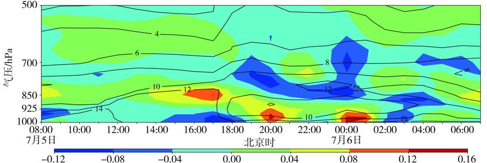
Fig.3 The height-time cross sections of water vapor flux divergence (color shaded areas, Unit: 10-6 g·hPa-1·cm-2·s-1) and specific humidity (black isolines, Unit: g·kg-1) in Sicundian station of Wuqing district in Tianjin from 08:00 BST on 5 to 07:00 BST on 6 July 2021
Fig.3 The height-time cross sections of water vapor flux divergence (color shaded areas, Unit: 10-6 g·hPa-1·cm-2·s-1) and specific humidity (black isolines, Unit: g·kg-1) in Sicundian station of Wuqing district in Tianjin from 08:00 BST on 5 to 07:00 BST on 6 July 2021
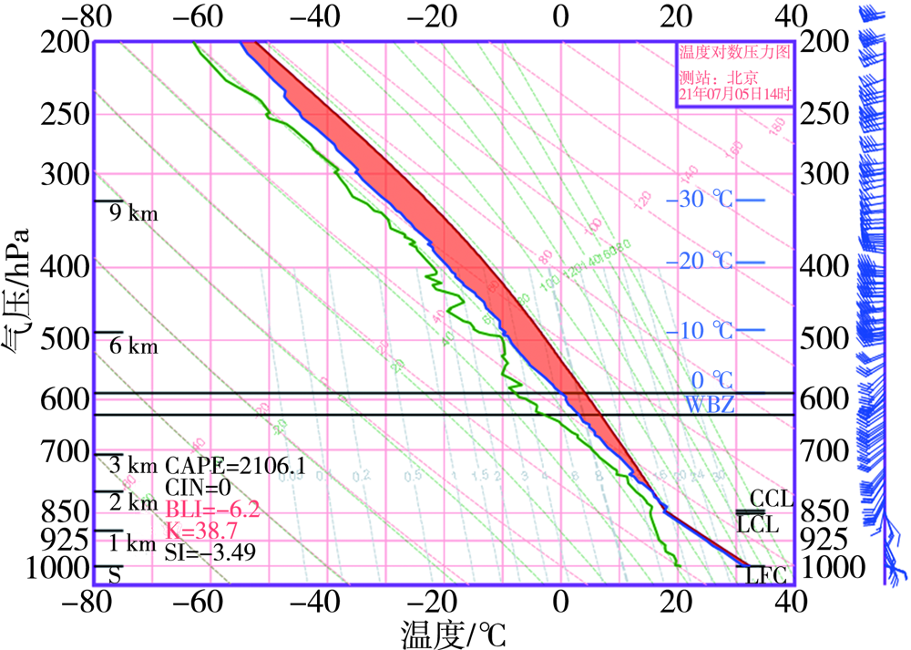
Fig.4 T-ln P of Beijing sounding station at 14:00 BST on 5 July 2021
Fig.4 T-ln P of Beijing sounding station at 14:00 BST on 5 July 2021
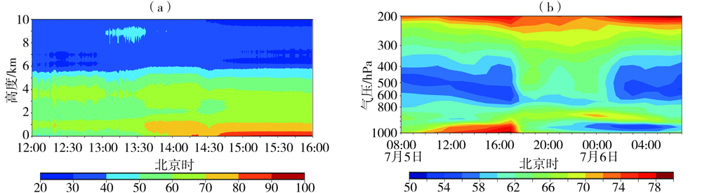
Fig.5 The height-time cross sections of relative humidity at Dachang station of Langfang from 12:00 BST to 16:00 BST on 5 (a, Unit: %) and θse in sub-central office area station of Tongzhou in Beijing from 08:00 BST on 5 to 07:00 BST on 6 (b, Unit: ℃) July 2021
Fig.5 The height-time cross sections of relative humidity at Dachang station of Langfang from 12:00 BST to 16:00 BST on 5 (a, Unit: %) and θse in sub-central office area station of Tongzhou in Beijing from 08:00 BST on 5 to 07:00 BST on 6 (b, Unit: ℃) July 2021
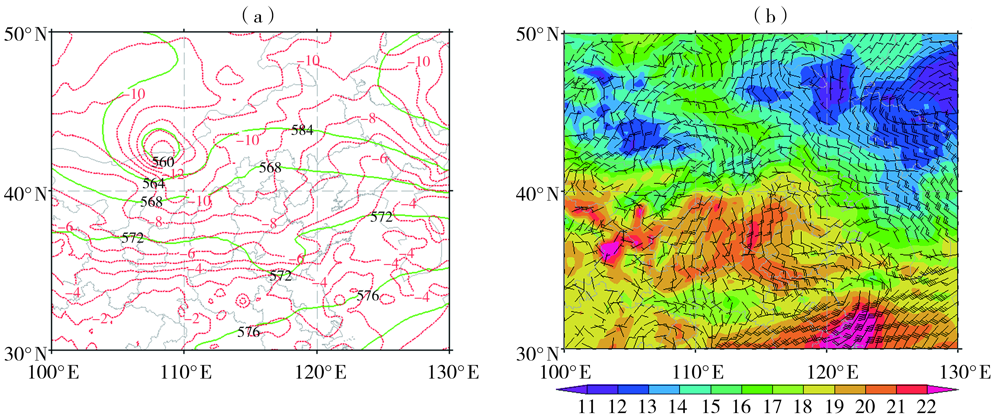
Fig.6 The geopotential height field (green solid isolines, Unit: dagpm), temperature field (red dotted isolines, Unit: ℃) at 500 hPa (a) and wind field (wind vectors, Unit: m·s-1), temperature field (color shaded areas, Unit: ℃) at 850 hPa (b) at 08:00 BST on 5 July 2021
Fig.6 The geopotential height field (green solid isolines, Unit: dagpm), temperature field (red dotted isolines, Unit: ℃) at 500 hPa (a) and wind field (wind vectors, Unit: m·s-1), temperature field (color shaded areas, Unit: ℃) at 850 hPa (b) at 08:00 BST on 5 July 2021
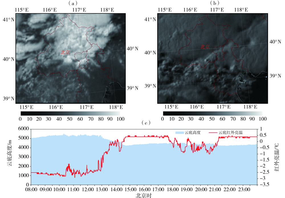
Fig.7 The visible cloud picture from FY-2G satellite (Unit: %) at 14:00 BST (a), 18:00 BST (b) and cloud base height, infrared brightness temperature from 08:00 BST to 23:59 BST at Dachang station of Langfang (c) on 5 July 2021
Fig.7 The visible cloud picture from FY-2G satellite (Unit: %) at 14:00 BST (a), 18:00 BST (b) and cloud base height, infrared brightness temperature from 08:00 BST to 23:59 BST at Dachang station of Langfang (c) on 5 July 2021
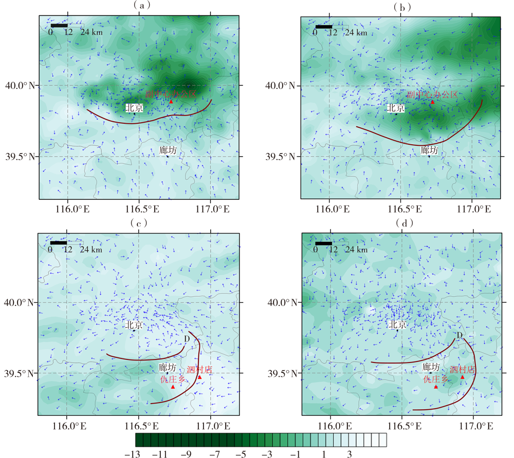
Fig.8 Hourly variation of surface temperature (color shaded areas, Unit: ℃) and direction of the wind (arrows) at 14:00 BST (a), 15:00 BST (b), 19:00 BST (c) and 20:00 BST (d) on 5 July 2021 (The brown solid lines are the ground convergence lines, letter D is the ground convergence center)
Fig.8 Hourly variation of surface temperature (color shaded areas, Unit: ℃) and direction of the wind (arrows) at 14:00 BST (a), 15:00 BST (b), 19:00 BST (c) and 20:00 BST (d) on 5 July 2021 (The brown solid lines are the ground convergence lines, letter D is the ground convergence center)
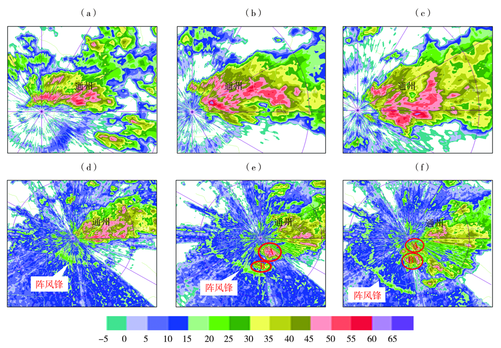
Fig.9 Radar reflectivity factor at 6.0° elevation angle (a, b, c) at 14:00 BST (a), 14:30 BST (b), 15:00 BST (c) and 0.5° elevation angle (d, e, f) at 15:00 BST (d), 15:30 BST (e), 16:00 BST (f) on 5 July 2021 from Beijing radar station (Unit:dBZ) (The letter A and B are convective cells)
Fig.9 Radar reflectivity factor at 6.0° elevation angle (a, b, c) at 14:00 BST (a), 14:30 BST (b), 15:00 BST (c) and 0.5° elevation angle (d, e, f) at 15:00 BST (d), 15:30 BST (e), 16:00 BST (f) on 5 July 2021 from Beijing radar station (Unit:dBZ) (The letter A and B are convective cells)
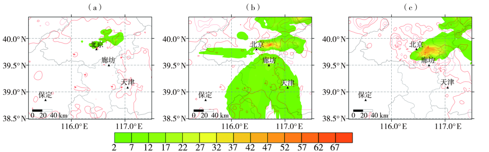
Fig.10 One-hour precipitation (color shaded areas, Unit: mm) and extreme wind speed (red isolines, Unit: m·s-1) at 14:00 BST (a), 15:00 BST (b) and 16:00 BST (c) on 5 July 2021
Fig.10 One-hour precipitation (color shaded areas, Unit: mm) and extreme wind speed (red isolines, Unit: m·s-1) at 14:00 BST (a), 15:00 BST (b) and 16:00 BST (c) on 5 July 2021
| [1] | 孙继松, 何娜, 王国荣, 等. “7.21”北京大暴雨系统的结构演变特征及成因初探[J]. 暴雨灾害, 2012, 31(3):218-225. |
| [2] | 孙伟, 曹舒娅, 解小寒, 等. 苏南一次深秋局地强对流的多源资料分析[J]. 沙漠与绿洲气象, 2018, 12(3):56-63. |
| [3] | 孙继松, 戴建华, 何立富, 等. 强对流天气预报的基本原理与技术方法:中国强对流天气预报手册[M]. 北京: 气象出版社, 2014:2-158. |
| [4] | 董春卿, 武永利, 郭媛媛, 等. 山西强对流天气分类指标与判据的应用[J]. 干旱气象, 2021, 39(2):345-355. |
| [5] | 张武龙, 康岚, 杨康权, 等. 四川盆地不同强度短时强降水物理量特征对比分析[J]. 气象, 2021, 47(4):439-449. |
| [6] | 郑媛媛, 姚晨, 郝莹, 等. 不同类型大尺度环流背景下强对流天气的短时临近预报预警研究[J]. 气象, 2011, 37(7):795-801. |
| [7] |
樊李苗, 俞小鼎. 中国短时强对流天气的若干环境参数特征分析[J]. 高原气象, 2013, 32(1):156-165.
DOI |
| [8] | 周雅蔓, 孙迪, 赵勇, 等. 新疆北部夏季大范围极端降水及其环流异常特征[J]. 干旱气象, 2021, 39(2):215-224. |
| [9] |
许敏, 张瑜, 张绍恢. 风廓线雷达资料在冀中一次强降水天气预报中的应用[J]. 干旱气象, 2016, 34(5):898-905.
DOI |
| [10] | 陈明轩, 肖现, 高峰. 出流边界对京津冀地区强对流局地新生及快速增强的动力效应[J]. 大气科学, 2017, 41(5):897-917. |
| [11] |
徐娟, 纪凡华, 韩风军, 等. 2012年盛夏山东西部一次短时强降水天气的形成机制[J]. 干旱气象, 2014, 32(3):439-445+459.
DOI |
| [12] | 崔丽曼, 苏爱芳, 张宇星, 等. 2016年河南省一次大范围强对流天气成因分析[J]. 气象与环境学报, 2020, 36(2):9-19. |
| [13] |
赵瑜, 赵桂香, 王思慜, 等. “7·28”山西中部强对流天气的中尺度分析[J]. 干旱气象, 2017, 35(5):874-885.
DOI |
| [14] | 张泽娇, 牛生杰, 丁辉. 利用亮温资料建立降水临近预报方法的研究[J]. 大气科学学报, 2015, 38(2):241-248. |
| [15] | 蔡奕萍, 汪博炜, 冼星河. 微波辐射计资料在降水临近预报中的应用[J]. 广东气象, 2018, 40(5):31-34. |
| [16] | 高美谭, 廖菲, 周芯玉, 等. 基于微波辐射计的短时强降水潜势预报[J]. 广东气象, 2021, 43(2):1-4. |
| [17] | 贺哲, 王君, 栗晗, 等. 河南省一次副高边缘对流性暴雨的多尺度特征[J]. 干旱气象, 2020, 38(3):423-432. |
| [18] | 田付友, 杨舒楠, 郑永光, 等. 北京地区两次极端特大暴雨过程中短时强降水环境条件对比分析[J]. 暴雨灾害, 2021, 40(1):27-36. |
| [19] | 方翀, 毛冬艳, 张小雯, 等. 2012年7月21日北京地区特大暴雨中尺度对流条件和特征初步分析[J]. 气象, 2012, 38(10):1278-1287. |
| [20] | 雷蕾, 邢楠, 周璇, 等. 2018年北京“7·16”暖区特大暴雨特征及形成机制研究[J]. 气象学报, 2020, 78(1):1-17. |
| [21] | 杨波, 孙继松, 毛旭, 等. 北京地区短时强降水过程的多尺度环流特征[J]. 气象学报, 2016, 74(6):919-934. |
| [22] |
SUN J Z, XUE M, WILSON J W, et al. Use of NWP for nowcasting convective precipitation: recent progress and challenges[J]. Bulletin of the American Meteorological Society, 2014, 95(3):409-426.
DOI URL |
| [23] |
JAMES P M, REICHERT B K, HEIZENREDER D. NowCastMIX: automatic integrated warning for severe convection on nowcasting time scales at the German weather service[J]. Weather and Forecasting, 2018, 33(5):1413-1433.
DOI URL |
| [24] | 于怀征, 刁秀广, 孟宪贵, 等. 山东省一次罕见强对流天气的环境场及雷达特征分析[J]. 暴雨灾害, 2020, 39(5):477-486. |
| [25] | 罗琪, 郑永光, 陈敏. 2017年北京北部一次罕见强弓状飑线过程演变和机理[J]. 气象学报, 2019, 77(3):371-386. |
| [26] | 孙京, 蔡然, 柴健, 等. 基于微波辐射计和闪电观测资料估算对流性降水方法初探[J]. 干旱气象, 2018, 36(3):438-446. |
| [27] |
DOSWELL C A, BROOKS H E, MADDOX R A. Flash flood forecasting: an ingradients-based methodology[J]. Weather and Forecasting, 1996, 11(4): 560-581.
DOI URL |
| [28] | 何跃, 李强, 刘伯骏, 等. 四川盆地一次西南涡作用下大暴雨过程的短时强降水分析[J]. 沙漠与绿洲气象, 2019, 13(6):29-38. |
| [29] | 朱乾根, 林锦瑞, 寿绍文, 等. 天气学原理和方法[M]. 北京: 气象出版社, 2007:422-426. |
| [30] | 张楠, 何群英, 刘彬贤, 等. 非典型环流形势下天津一次局地暴雨过程中尺度特征分析[J]. 暴雨灾害, 2018, 37(3):230-237. |
| [31] | 雷蕾, 孙继松, 乔林, 等. 一次超级单体雹暴的中尺度对流特征和形成条件分析[J]. 气象科技进展, 2019, 9(5):16-23. |
| [32] | 程月星, 孙继松, 戴高菊, 等. 2016年北京地区一次雷暴大风的观测研究[J]. 气象, 2018, 44(12):1529-1541. |
| [33] |
WILSON J W, FENG Y, CHEN M, et al. Nowcasting challenges during the Beijing Olympics: successes, failures, and implications for future nowcasting systems[J]. Weather and Forecasting, 2010, 25(6):1691-1714.
DOI URL |
| [34] |
WILSON J W, SCHREIBER W E. Initiation of convective storms at radar-observed boundary-layer convergence lines[J]. Monthly Weather Review, 1986, 114(12):2516-2536.
DOI URL |
| [35] | 丁青兰, 王令, 卞素芬, 等. 北京局地降水中地形和边界层辐合线的作用[J]. 气象科技, 2009, 37(2):152-155+261. |
| [1] |
XIAO Yiqing , MA Yongyong , CHEN Xiaoting , AN Dawei , HUANG Shaoni.
A short-time heavy precipitation process triggered by a cold front in the Hanjiang Basin of southern Shaanxi and its precipitation forecast verification
|
| [2] | FENG Jinqin, LU Yunyun, LAI Qiaozhen, CAI Jing. Analysis of trigger mechanism of a mesoscale covective system in western mountainous area of Fujian [J]. Journal of Arid Meteorology, 2022, 40(1): 62-72. |
| [3] | ZHU Li,LU Dequan,LIAO Wenchao,ZHENG Linlin. Comparative Analysis of Causes of Two Consecutive Squall Line Gales [J]. Journal of Arid Meteorology, 2021, 39(5): 796-806. |
| [4] | NIE Yun, ZHOU Jixian, LI Xijin, RAN Yang, CHEN Chao. Environmental Condition and Structure Feature of a Warm-sector Squall Line Process in Guizhou Province [J]. Journal of Arid Meteorology, 2020, 38(5): 782-793. |
| [5] | GUAN Xiaojun, QIN Jing. Motion and Intensity Characteristics of a Strong Squall Line Process Affecting Fujian Province#br# [J]. Journal of Arid Meteorology, 2019, 37(5): 799-808. |
| [6] | ZENG Yong, YANG Lianmei, ZHANG Yingxin. Mechanism Analysis of Dry Intrusion During a Severe Convective Weather Process Under the Background of Central Asian Vortex in Aksu Area of Xinjiang [J]. Journal of Arid Meteorology, 2018, 36(1): 34-43. |
| [7] | ZHAO Yu, ZHAO Guixiang, WANG Simin, SHEN Liwen. Meso-scale Analysis of A Strong Convective Weather Process Occuring on 28 July 2016 in Central Shanxi Province [J]. Journal of Arid Meteorology, 2017, 35(5): 874-885. |
| [8] | ZHUANG Xiaocui, QIN Jiaxiu, LI Boyuan. Mesoscale Characteristics of a Snowstorm in Western Xinjiang in 2014 [J]. Journal of Arid Meteorology, 2016, 34(2): 326-334. |
| [9] | WEI Yong,PENG Jun,RESULI Abula,WANG Cunliang,CHEN Jianmin. Comprehensive Analysis of a Severe Hail in the Middle Section on Northern Slope of Tianshan Mountain in Xinjiang [J]. Journal of Arid Meteorology, 2013, 31(4): 771-777. |
| [10] | SU Junfeng,Lü Hong,YAN Huiling,WEI Bangxian,YANG Jian’an,CHU Xiaoju. Analysis of the Mesoscale Characteristics of a Rainstorm Process [J]. Journal of Arid Meteorology, 2013, 31(1): 156-162. |
| Viewed | ||||||
|
Full text |
|
|||||
|
Abstract |
|
|||||