Journal of Arid Meteorology ›› 2023, Vol. 41 ›› Issue (5): 764-773.DOI: 10.11755/j.issn.1006-7639(2023)-05-0764
• Articles • Previous Articles Next Articles
Analysis on development mechanism of two consecutive warm zone squall lines in Zhejiang Province
QIAN Zhuolei1( ), ZHAO Chiyu3, ZHU Zhejun2, SHENG Zhewen1
- 1. Shaoxing Meteorological Observatory of Zhejiang Province, Shaoxing 312000, Zhejiang, China
2. Shaoxing Meteorological Disaster Prevention and Reduction Center of Zhejiang Province, Shaoxing 312000, Zhejiang, China
3. Shaoxing Meteorological Service Center of Zhejiang Province, Shaoxing 312000, Zhejiang, China
-
Received:2022-06-01Revised:2022-09-20Online:2023-10-31Published:2023-11-03
浙江连续两次暖区飑线发展机制分析
- 1.浙江省绍兴市气象台,浙江 绍兴 312000
2.浙江省绍兴市气象防灾减灾中心,浙江 绍兴 312000
3.浙江省绍兴市气象服务中心,浙江 绍兴 312000
-
作者简介:钱卓蕾(1985—),女,硕士,高级工程师,主要从事天气预报和气候研究工作。E-mail:1033404758@qq.com。 -
基金资助:浙江省气象局重点项目(2021ZD28)
CLC Number:
Cite this article
QIAN Zhuolei, ZHAO Chiyu, ZHU Zhejun, SHENG Zhewen. Analysis on development mechanism of two consecutive warm zone squall lines in Zhejiang Province[J]. Journal of Arid Meteorology, 2023, 41(5): 764-773.
钱卓蕾, 赵驰宇, 朱哲君, 沈哲文. 浙江连续两次暖区飑线发展机制分析[J]. 干旱气象, 2023, 41(5): 764-773.
share this article
Add to citation manager EndNote|Ris|BibTeX
URL: http://www.ghqx.org.cn/EN/10.11755/j.issn.1006-7639(2023)-05-0764
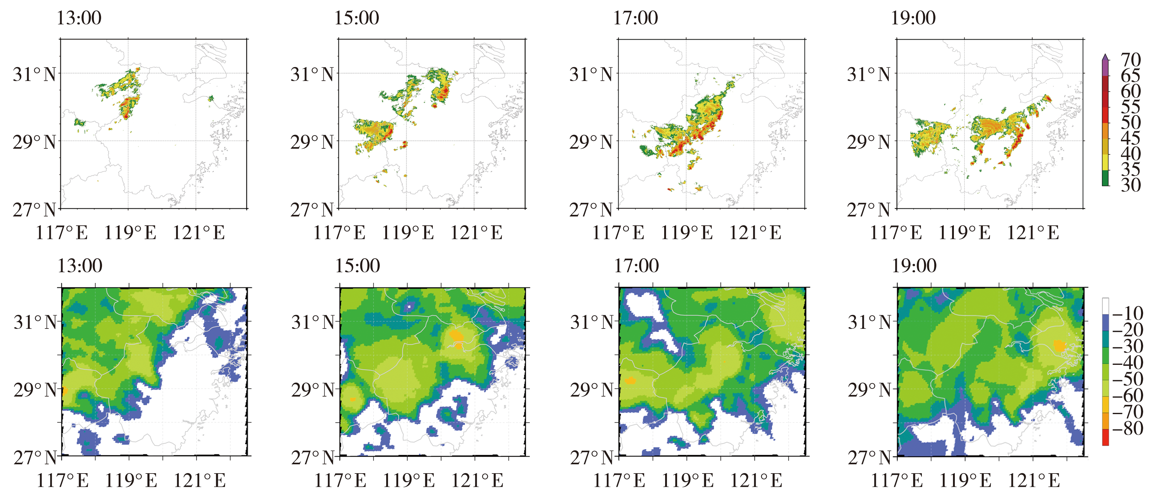
Fig.1 The evolution of combined reflectivity factor at Jinhua station (the top, Unit: dBZ) and TBB (the bottom, Unit: ℃) on 25 April 2022
Fig.1 The evolution of combined reflectivity factor at Jinhua station (the top, Unit: dBZ) and TBB (the bottom, Unit: ℃) on 25 April 2022
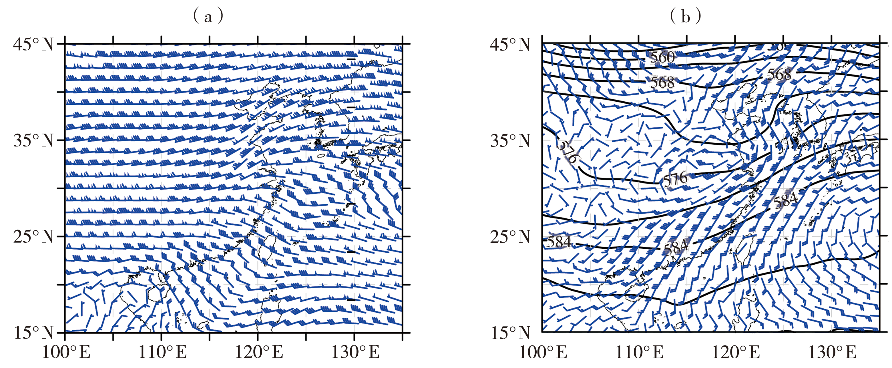
Fig.2 The 200 hPa wind field (wind vectors, Unit: m·s-1) (a), 500 hPa geopotential height field (contours, Unti: gpm) and 850 hPa wind field (wind vectors, Unit: m·s-1) (b) at 12:00 on 25 April 2022
Fig.2 The 200 hPa wind field (wind vectors, Unit: m·s-1) (a), 500 hPa geopotential height field (contours, Unti: gpm) and 850 hPa wind field (wind vectors, Unit: m·s-1) (b) at 12:00 on 25 April 2022

Fig.3 The sounding curves at Jiaxing station at 11:00 (a) and Shaoxing station at 14:00 (b) on 25 April 2022 (The red thick line is the stratification curve, and the dark green thick line is the dew point curve, and the vertical wind field is shown on the right)
Fig.3 The sounding curves at Jiaxing station at 11:00 (a) and Shaoxing station at 14:00 (b) on 25 April 2022 (The red thick line is the stratification curve, and the dark green thick line is the dew point curve, and the vertical wind field is shown on the right)
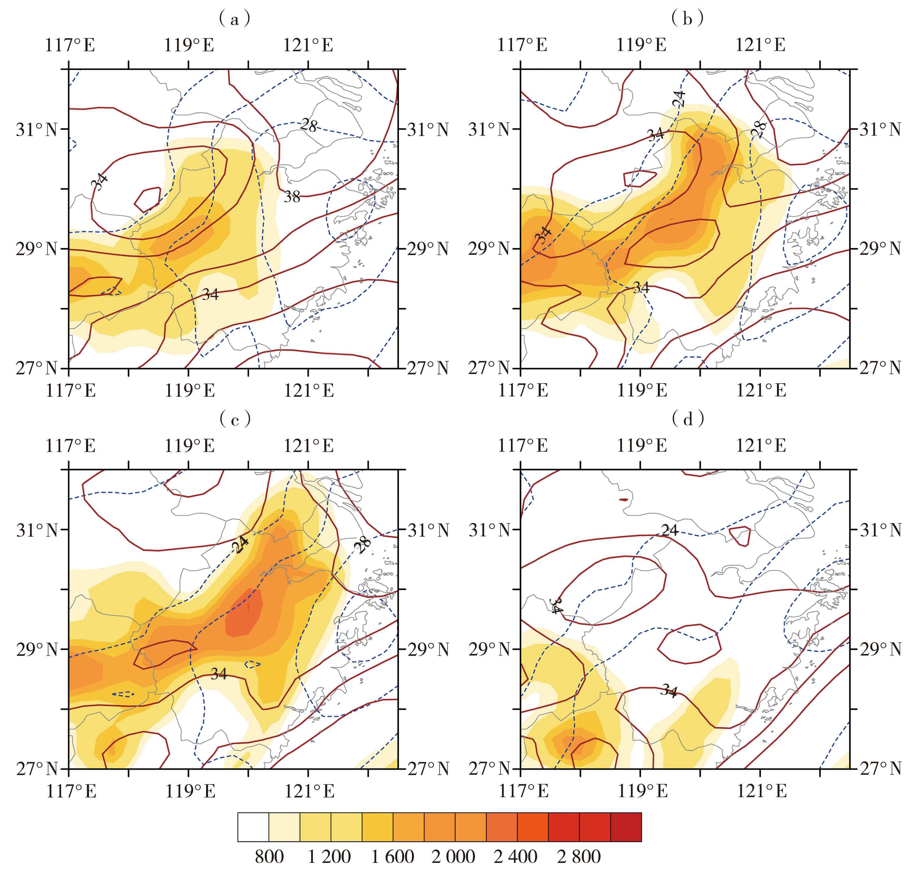
Fig.4 Distribution of convective effective potential energy (color shaded, Unit: J·kg-1), K index (brown solid lines, Unit: °C) and temperature difference between 850 hPa and 500 hPa (blue dotted lines, Unit: °C) at 12:00 (a), 14:00 (b), 16:00 (c) and 18:00 (d) on 25 April 2022
Fig.4 Distribution of convective effective potential energy (color shaded, Unit: J·kg-1), K index (brown solid lines, Unit: °C) and temperature difference between 850 hPa and 500 hPa (blue dotted lines, Unit: °C) at 12:00 (a), 14:00 (b), 16:00 (c) and 18:00 (d) on 25 April 2022

Fig.5 The vertical section of vortex potential (isolines, Unit: 10-6 m2·s-1·K·kg-1), relative humidity (color shaded, Unit: %) and wind field (wind vectors, Unit: m·s-1) on the isentropic surface at 12:00 (a), 14:00 (b), 16:00 (c) and 18:00 (d) on 25 April 2022
Fig.5 The vertical section of vortex potential (isolines, Unit: 10-6 m2·s-1·K·kg-1), relative humidity (color shaded, Unit: %) and wind field (wind vectors, Unit: m·s-1) on the isentropic surface at 12:00 (a), 14:00 (b), 16:00 (c) and 18:00 (d) on 25 April 2022

Fig.6 The one-hour surface extremely strong wind (wind vectors, Unit: m·s-1), one-hour pressure change (isolines, Unit: hPa) and radar reflectivity factor on 0.5° elevation at Jinhua station (color shaded, Unit: dBZ) at 13:00 (a), 15:00 (b), 17:00 (c) and 19:00 (d) on 25 April 2022 (The red thick dashed line represents the mesoscale convergence line)
Fig.6 The one-hour surface extremely strong wind (wind vectors, Unit: m·s-1), one-hour pressure change (isolines, Unit: hPa) and radar reflectivity factor on 0.5° elevation at Jinhua station (color shaded, Unit: dBZ) at 13:00 (a), 15:00 (b), 17:00 (c) and 19:00 (d) on 25 April 2022 (The red thick dashed line represents the mesoscale convergence line)
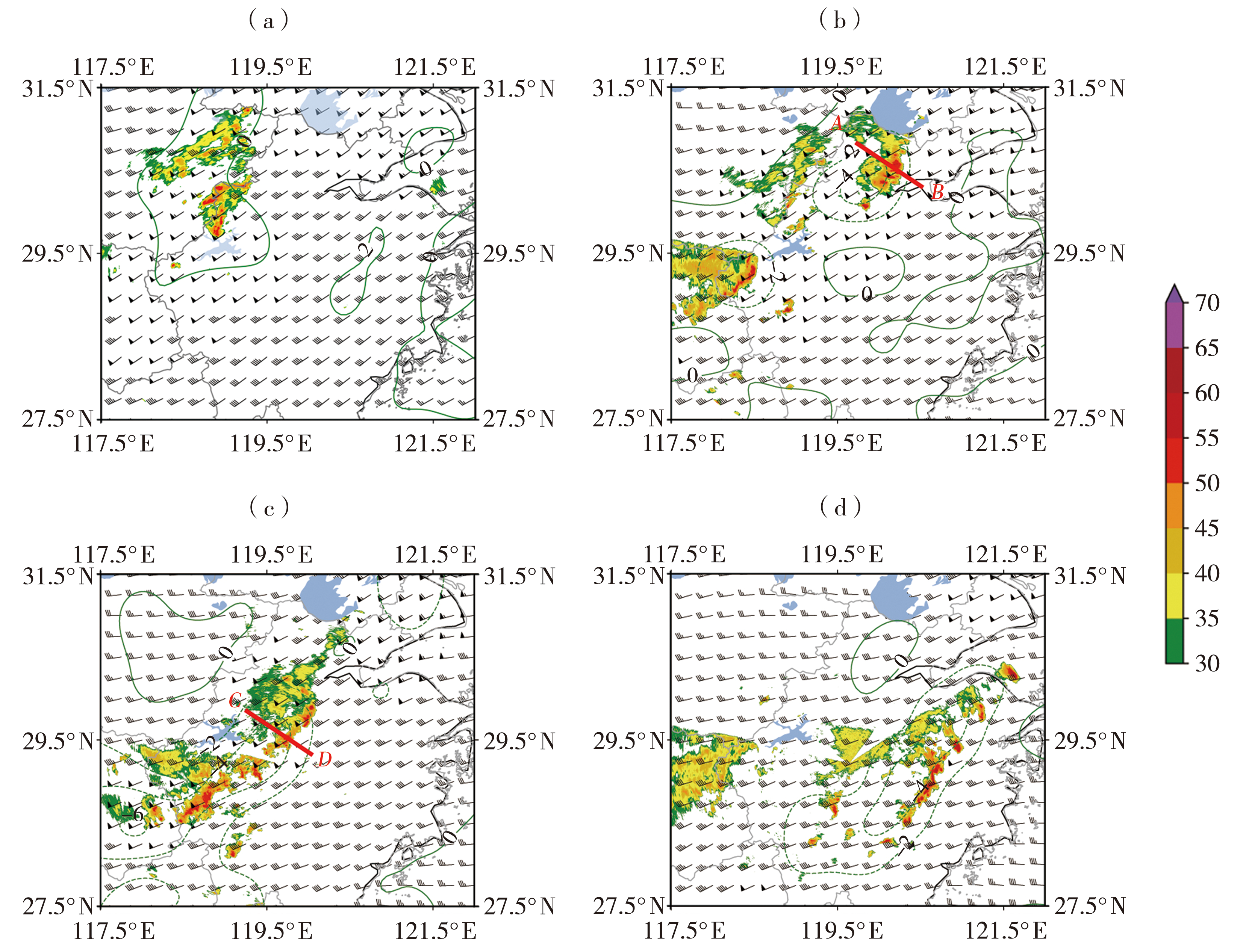
Fig.7 Vertical wind shear from 0 to 3 km (wind vectors, Unit: m·s-1), one-hour ground temperature change (isolines, Unit: °C) and radar reflectivity factor (color shaded, Unit: dBZ) on 0.5° elevation at Jinhua station at 13:00 (a), 15:00 (b), 17:00 (c), 19:00 (d) on 25 April 2022
Fig.7 Vertical wind shear from 0 to 3 km (wind vectors, Unit: m·s-1), one-hour ground temperature change (isolines, Unit: °C) and radar reflectivity factor (color shaded, Unit: dBZ) on 0.5° elevation at Jinhua station at 13:00 (a), 15:00 (b), 17:00 (c), 19:00 (d) on 25 April 2022
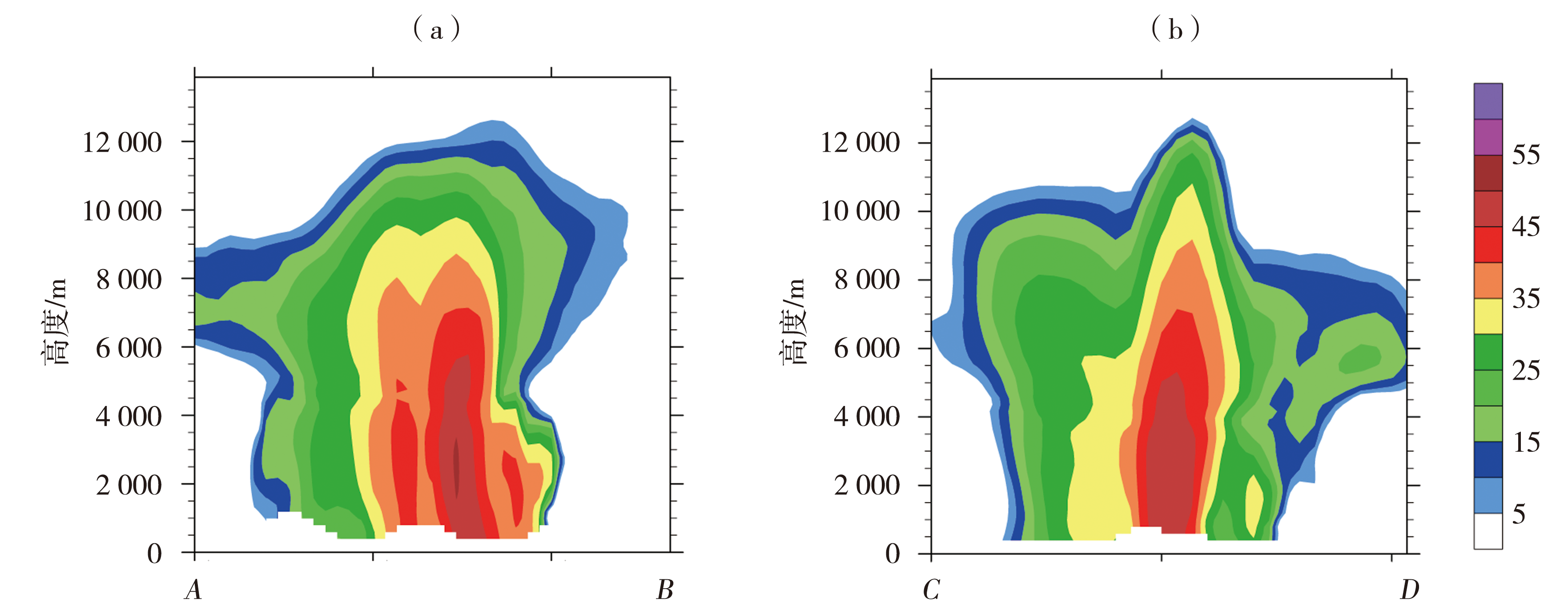
Fig.8 Vertical profiles of reflectivity factor along vertical direction of the squall line (the AB and CD segments in fig.7) at 15:00 (a) and 17:00 (b) on 25 April 2022 (Unit: dBZ)
Fig.8 Vertical profiles of reflectivity factor along vertical direction of the squall line (the AB and CD segments in fig.7) at 15:00 (a) and 17:00 (b) on 25 April 2022 (Unit: dBZ)

Fig.9 Schematic diagram of the development of two consecutive squall lines
Fig.9 Schematic diagram of the development of two consecutive squall lines
| [1] | 鲍旭炜, 谈哲敏, 2010. 二维多单体雷暴系统中对流单体生成和发展的新机制[J]. 气象学报, 68(3): 296-308. |
| [2] | 陈明轩, 王迎春, 2012. 低层垂直风切变和冷池相互作用影响华北地区一次飑线过程发展维持的数值模拟[J]. 气象学报, 70(3): 371-386. |
| [3] | 崔强, 王春明, 张云, 2016. 干侵入对江淮流域一次强飑线过程的作用分析[J]. 沙漠与绿洲气象, 10 (2): 18-24. |
| [4] |
曹倩, 雷桂莲, 易艳红, 等, 2022. 不同雷达观测资料同化对一次罕见飑线天气模拟的影响[J]. 干旱气象, 40(3): 469-484.
DOI |
| [5] | 高梦竹, 陈耀登, 章丽娜, 等, 2017. 对流移入杭州湾后飑线发展机制分析[J]. 气象, 43(1): 56-66. |
| [6] | 罗建英, 廖胜石, 梁岱云, 等, 2006. 2005 年3 月22 日华南飑线的综合分析[J]. 气象, 32(10): 70-76. |
| [7] | 刘莲, 王迎春, 陈明轩, 2015. 京津冀一次飑线过程的精细时空演变特征分析[J]. 气象, 41(12): 1 433-1 446. |
| [8] | 李文娟, 俞小鼎, 滕代高, 等, 2021. 中国江南—华南地区一次强飑线天气过程位涡诊断分析[J]. 气象与环境学报, 37(6): 1-10. |
| [9] | 农孟松, 翟丽萍, 屈梅芳, 等, 2014. 广西一次飑线大风天气的成因和预警分析[J]. 气象, 40(12): 1 491-1 499. |
| [10] | 寿绍文, 励申申, 姚秀萍, 2003. 中尺度气象学[M]. 北京: 气象出版社:83. |
| [11] | 沈杭锋, 翟国庆, 朱补全, 等, 2021. 浙江沿海中尺度辐合线对飑线发展影响的数值试验[J]. 大气科学, 34(6): 1 127-1 140. |
| [12] | 吴海英, 陈海山, 蒋义芳, 等, 2013. “090603”强飑线过程动力结构特征的观测与模拟分析[J]. 高原气象, 32(4): 1 084-1 094. |
| [13] | 吴迪, 姚秀萍, 寿绍文, 2010. 干侵入对一次东北冷涡过程的作用分析[J]. 高原气象, 29(5): 1 208-1 217. |
| [14] | 吴志彦, 闵锦忠, 赵海军, 2017. 冷涡背景下一次强对流过程的卫星水汽图像特征[J]. 海洋气象学报, 37(3): 54-61. |
| [15] | 于玉斌, 姚秀萍, 2003. 干侵入的研究及其应用进展[J]. 气象学报, 61(6): 669-778. |
| [16] | 俞小鼎, 周小刚, 王秀明, 2012. 雷暴与强对流临近天气预报技术进展[J]. 气象学报, 70(3): 311-337. |
| [17] | 翟国庆, 俞樟孝, 1991. 华东飑线过程中的地面中尺度物理特征[J]. 大气科学, 15(6): 63-69. |
| [18] | 章国材, 矫梅燕, 李延香, 等, 2007. 现代天气预报技术和方法[M]. 北京: 气象出版社:133. |
| [19] | 庄薇, 刘黎平, 薄兆海, 等, 2010. 新疆一次强飑线过程双多普勒雷达观测的中尺度风场结构分析[J]. 气象学报, 68(2): 224-334. |
| [20] | 张建军, 王咏青, 钟玮, 2016. 飑线组织化过程对环境垂直风切变和水汽的响应[J]. 大气科学, 40(4): 689-702. |
| [21] |
竹利, 卢德全, 廖文超, 等, 2021. 连续两次飑线大风成因对比分析[J]. 干旱气象, 39(5): 796-806.
DOI |
| [22] |
BROWNING K A, GOLDING B W, 1995. Mesoscale aspects of a dry intrusion within a vigorous cyclone[J]. Quarterly Journal of the Royal Meteorological Society, 121(523): 463-493.
DOI URL |
| [23] | BLUESTEIN H B, JAIN M H, 1985. Formation of mesoscale lines of precipitation: severe squall lines in Oklahoma during the spring[J]. Journal of the Atmospheric Sciences, 42(16): 1 711-1 732. |
| [24] |
BRYAN G H, KNIEVEL J C, PARKER M D, 2006. A multi-model assessment of RKW theory’s relevance to squall-line characteristics[J]. Monthly Weather Review, 134(10): 2 772-2 792.
DOI URL |
| [25] | CONIGLIO M C, CORFIDI S F, KAIN J S, 2012. Views on applying RKW theory: an illustration using the 8 May 2009 derecho-producing convective system[J]. Monthly Weather Review, 140(3): 1 023-1 043. |
| [26] |
FUJITA T, 1955. Results of detailed synoptic studies of squall lines[J]. Tellus, 7(4): 405-436.
DOI URL |
| [27] | NEWTON C W, 1966. Circulations in large sheared cumulonimbus[J]. Tellus, 18(4): 699-713. |
| [28] | PARKER M D, JOHNSON R H, 2000. Organizational modes of midlatitude mesoscale convective systems[J]. Monthly Weather Review, 128(10): 3 413-3 436. |
| [29] |
ROTUNNO R, KLEMP J B, WEISMAN M L, 1988. A theory for strong, long-lived squall lines[J]. Journal of Atmospheric Sciences, 45(3): 463-485.
DOI URL |
| [30] | THORPE A J, MILLER M J, MONCRIEFF M W, 1982. Two-dimensional convection in non-constant shear: a model of mid-latitude squall lines[J]. Quarterly Journal of the Royal Meteorological Society, 108(458): 739-762. |
| [31] | WECKWERTH T M, 2000. The effect of small-scale moisture variability on thunderstorm initiation[J]. Monthly Weather Review, 128(12): 4 017-4 030. |
| [32] | WEISMAN M L, 1992. The role of convectively generated rear-inflow jets in the evolution of long-lived meso-convective systems[J]. Journal of Atmospheric Sciences, 49(19): 1 826-1 847. |
| [1] | CHU Yingjia, GUO Feiyan, GAO Fan, HU Peng, ZHENG Lina, LIU Yichen, LU Qi. Comparative analysis of two different types of severe convective processes under the influence of cold vortex [J]. Journal of Arid Meteorology, 2023, 41(2): 279-289. |
| [2] | WEI Huihong, WU Cuihong, WEI Fan, LU Yi, KONG Haimei, ZHAO Huan. Analysis of thunderstorm gust front characteristics and its convection triggering effect in Hubei Province [J]. Journal of Arid Meteorology, 2023, 41(1): 73-81. |
| [3] | CAO Qian, LEI Guilian, YI Yanhong, ZHANG Yizhi, LIU Liangyu, PENG Wangminzi. Impact of different radar data assimilation on a rare strong squall line simulation [J]. Journal of Arid Meteorology, 2022, 40(3): 469-484. |
| [4] | ZHU Li,LU Dequan,LIAO Wenchao,ZHENG Linlin. Comparative Analysis of Causes of Two Consecutive Squall Line Gales [J]. Journal of Arid Meteorology, 2021, 39(5): 796-806. |
| [5] | WU Bin, QIAN Ye, WANG Ruifang, ZHAO Xin, JIN Lei. Assessment of Largescale Environmental Factors Affecting Typhoon Intensity in Northwest Pacific Simulated by Global Climate Models [J]. Journal of Arid Meteorology, 2021, 39(3): 466-479. |
| [6] | NIE Yun, ZHOU Jixian, LI Xijin, RAN Yang, CHEN Chao. Environmental Condition and Structure Feature of a Warm-sector Squall Line Process in Guizhou Province [J]. Journal of Arid Meteorology, 2020, 38(5): 782-793. |
| [7] | GUAN Xiaojun, QIN Jing. Motion and Intensity Characteristics of a Strong Squall Line Process Affecting Fujian Province#br# [J]. Journal of Arid Meteorology, 2019, 37(5): 799-808. |
| [8] | LI Sirong, MIAO Aimei, WANG Hongxia. Cloud Image Characteristics and Maintaining Mechanism of a Squall Line in Autumn in Shanxi Province [J]. Journal of Arid Meteorology, 2019, 37(2): 312-321. |
| [9] | WANG Qiang, TANG Minghui, WANG Qihuan, ZHANG Xiao. Comparative Analysis of Squall Line Weather Processes in Different Seasons in Hunan Province [J]. Journal of Arid Meteorology, 2018, 36(5): 782-793. |
| [10] | GAO Xiaomei1, SUN Xuefeng2, QIN Yupeng1, WANG Shijie1, WANG Wenbo1. Environmental Conditions and Convective Storm Features of a Severe Convective Weather Process in Shandong Province [J]. Journal of Arid Meteorology, 2018, 36(3): 447-. |
| [11] | ZHANG Qin1, ZHANG Xiao2, MENG Wei1, LI Shuling1, HU Xiaolin1. Environmental Conditions and Doppler Radar Characteristic of Two Consecutive Severe Convection Weather in Shandong Province [J]. Journal of Arid Meteorology, 2018, 36(3): 465-. |
| [12] | MIAO Aimei, DONG Chunqing, WANG Hongxia, ZHANG Weimin. Characteristics of Doppler Radars Echo During the Squall Line Process in North China on 13 June 2016 [J]. Journal of Arid Meteorology, 2017, 35(6): 1015-1026. |
| [13] | CHEN Jun, LI Xiaolan, YU Yijun, FANG Biao, TENG Lin, HU Ping. Analysis on a Large-range Elevated Thunderstorm HailWeather Process in Tongren of Guizhou [J]. Journal of Arid Meteorology, 2017, 35(4): 649-656. |
| [14] | . Mesoscale Characteristic Analysis of a Severe Convective Weather with Torrential Rain in the West of Southern Xinjiang [J]. Journal of Arid Meteorology, 2017, 35(3): 475-. |
| [15] | TANG Jia, YAO Rong, WANG Xiaolei, TANG Minghui, ZHOU Changqing. Contrastive Analysis of Two Mixed Convective Weather Processes in Hu’nan in Spring of 2015 [J]. Journal of Arid Meteorology, 2017, 35(2): 250-259. |
| Viewed | ||||||
|
Full text |
|
|||||
|
Abstract |
|
|||||