干旱气象 ›› 2023, Vol. 41 ›› Issue (3): 368-379.DOI: 10.11755/j.issn.1006-7639(2023)-03-0368
CLM 5.0对干旱环境中高寒山区土壤温度模拟的适用性评估
- 兰州大学资源环境学院,西部环境教育部重点实验室,甘肃 兰州 730000
-
收稿日期:2022-12-11修回日期:2023-03-02出版日期:2023-06-30发布日期:2023-07-02 -
通讯作者:张兰慧 -
作者简介:曾璇(1998—),女,四川德阳人,硕士生,主要从事陆面模式的适用性评估。E-mail: zengx2020@lzu.edu.cn。 -
基金资助:国家自然科学基金面上项目“祁连山区土壤水分对陆面水文过程的影响机理和模拟研究(41877148)
Evaluation of CLM 5.0 on simulating soil temperature in alpine mountainous area in arid environment
ZENG Xuan( ), ZHANG Lanhui(), BAI Xuliang, LIU Yu, AN Qi
- College of Earth and Environmental Sciences, Lanzhou University, Key Laboratory of Western China’s Environmental Systems, Ministry of Education, Lanzhou 730000, China
-
Received:2022-12-11Revised:2023-03-02Online:2023-06-30Published:2023-07-02 -
Contact:ZHANG Lanhui
摘要:
土壤温度反映土壤的热状态,对地表能量交换起重要作用,是影响土壤水热再分配的关键性因素。高寒山区水热传输复杂且特殊,准确模拟土壤温度对于研究高寒山区水循环过程有重要意义。CLM 5.0 (Community Land Model 5.0)是CLM模式的最新版本,是目前国际上最先进的陆面过程模式之一。本文基于黑河流域上游9个典型观测站实测数据,对CLM 5.0的土壤温度模拟性能进行评估。结果表明:(1)CLM 5.0可以很好地模拟土壤温度在高寒山区的年内变化和年际变化,但模拟值相较实测值普遍存在低估。(2)CLM 5.0对土壤温度的模拟性能在高寒草甸略高于草地,土壤浅层优于深层。(3)CLM 5.0模拟的土壤温度在生长季和非生长季均呈现低估,且非生长季低估更明显;在冻结期和非冻结期均为低估,且冻结期低估更明显。(4)非生长季土壤温度的明显低估主要是冻结期土壤温度的明显低估引起,CLM 5.0中土壤冰的模拟偏差是主要原因。以上结论可为陆面过程模式CLM 5.0在高寒山区的应用及改进提供科学依据。
中图分类号:
引用本文
曾璇, 张兰慧, 白旭亮, 刘宇, 安琦. CLM 5.0对干旱环境中高寒山区土壤温度模拟的适用性评估[J]. 干旱气象, 2023, 41(3): 368-379.
ZENG Xuan, ZHANG Lanhui, BAI Xuliang, LIU Yu, AN Qi. Evaluation of CLM 5.0 on simulating soil temperature in alpine mountainous area in arid environment[J]. Journal of Arid Meteorology, 2023, 41(3): 368-379.
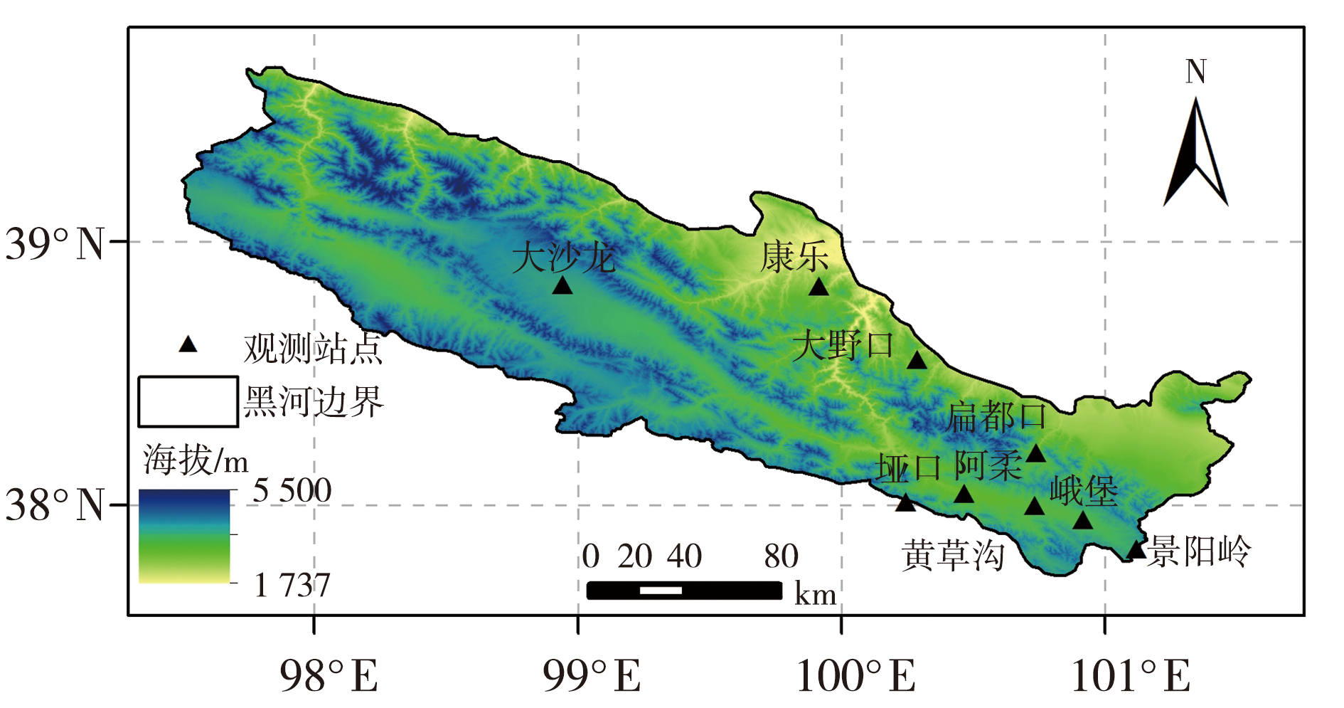
图1 黑河流域上游地形及9个观测站点空间分布
Fig.1 Topography and spatial distribution of 9 observation stations in the upper reaches of the Heihe River Basin
图1 黑河流域上游地形及9个观测站点空间分布
Fig.1 Topography and spatial distribution of 9 observation stations in the upper reaches of the Heihe River Basin
表1 黑河流域上游9个观测站数据的详细说明
Tab.1 Detailed information of data at 9 observation stations in the upper reaches of the Heihe River Basin
| 站名 | 经度 | 纬度 | 海拔/m | 下垫面类型 | 数据时间 | 时间分辨率/min |
|---|---|---|---|---|---|---|
| 阿柔 | 100.464°E | 38.047°N | 3 033 | 亚高山山地草甸 | 2013—2019年 | 30 |
| 扁都口 | 100.737°E | 38.201°N | 2 886 | 农牧交错带草地 | 2016—2018年 | 30 |
| 大沙龙 | 98.941°E | 38.840°N | 3 739 | 沼泽化高寒草甸 | 2015—2018年 | 30 |
| 大野口 | 100.285°E | 38.556°N | 2 698 | 森林草地过渡带草地 | 2015—2018年 | 30 |
| 峨堡 | 100.915°E | 37.949°N | 3 294 | 草地 | 2014—2015年 | 30 |
| 黄草沟 | 100.731°E | 38.003°N | 3 137 | 草地 | 2014年 | 30 |
| 景阳岭 | 101.116°E | 37.838°N | 3 750 | 高寒草甸 | 2019年 | 30 |
| 康乐 | 99.913°E | 38.834°N | 2 839 | 草原草地 | 2016—2018年 | 30 |
| 垭口 | 100.242°E | 38.014°N | 4 148 | 高寒草甸 | 2015—2018年 | 30 |
表2 黑河流域上游9个观测站土壤温度模拟值和实测值的土壤层数及其对应深度
Tab.2 The soil layers and their corresponding depths of simulated and observed soil temperature at 9 observation stations in the upper reaches of the Heihe River Basin
| 处理后 | 实测土壤温度 | 模拟土壤温度 | |||||||||
|---|---|---|---|---|---|---|---|---|---|---|---|
| 扁都口、大野口、康乐站 | 阿柔站 | 其余站 | 阿柔站 | 其余站 | |||||||
| 土壤层数 | 土壤深度/cm | 土壤层数 | 土壤深度/cm | 土壤层数 | 土壤深度/cm | 土壤层数 | 土壤深度/cm | 土壤层数 | 土壤深度/cm | 土壤层数 | 土壤深度/cm |
| 1 | [0, 12] | 1 | [0, 10] | 1~2 | [0, 15] | 1~2 | [0, 15] | 1~3 | [0, 12] | 1~3 | [0, 12] |
| 2 | (12, 32] | 2~3 | (10, 30] | 3 | (15, 30] | 3 | (15, 30] | 4~5 | (12, 32] | 4~5 | (12, 32] |
| 3 | (32, 68] | 4~5 | (30, 70] | 4 | (30, 50] | 4 | (30, 60] | 6 | (32, 48] | 6~7 | (32, 68] |
表3 不同年份黑河流域上游9个观测站的非冻结期
Tab.3 The unfrozen periods at 9 observation stations in the upper reaches of the Heihe River Basin in different years
| 站点 | 非冻结期 |
|---|---|
| 阿柔 | 2013年5月3日至11月2日,2014年5月3日至11月16日,2015年5月7日至11月13日,2016年5月4日至11月9日,2017年5月2日至11月12日,2018年5月3日至11月13日,2019年4月30日至11月14日 |
| 扁都口 | 2016年4月4日至11月28日,2017年3月30日至11月24日,2018年3月21日至11月20日 |
| 大沙龙 | 2015年5月27日至10月27日,2016年5月26日至10月25日,2017年5月29日至10月26日,2018年5月20日至10月18日 |
| 大野口 | 2015年5月1日至11月9日,2016年4月27日至11月1日,2017年5月1日至11月12日,2018年5月6日至11月3日 |
| 峨堡 | 2014年5月31日至11月3日,2015年6月1日至10月31日 |
| 黄草沟 | 2014年5月14日至11月2日 |
| 景阳岭 | 2019年5月30日至10月24日 |
| 康乐 | 2016年3月26日至11月8日,2017年3月27日至11月14日,2018年3月14日至11月7日 |
| 垭口 | 2016年6月23日至10月5日,2017年6月28日至10月8日,2018年6月19日至9月26 |

图2 黑河流域上游9个观测站土壤温度观测值与CLM 5.0模拟值对比
Fig.2 Comparison of observed soil temperature and CLM 5.0 simulated value at 9 observation stations in the upper reaches of the Heihe River Basin
图2 黑河流域上游9个观测站土壤温度观测值与CLM 5.0模拟值对比
Fig.2 Comparison of observed soil temperature and CLM 5.0 simulated value at 9 observation stations in the upper reaches of the Heihe River Basin

图3 黑河流域上游9个观测站不同土壤层CLM 5.0模拟与实测土壤温度对比的泰勒图 (红色站点、蓝色站点的植被类型分别为高寒草甸、草地)(a)整层,(b)第1层,(c)第2层,(d)第3层
Fig.3 Taylor diagram of CLM 5.0 simulatied and observed soil temperature in different layers of 9 observation stations in the upper reaches of the Heihe River Basin (The vegetation types of red stations and blue stations are alpine meadow and grassland respectively)(a) the entire soil profile, (b) layer 1, (c) layer 2, (d) layer 3

图4 黑河流域上游9个观测站不同土壤层土壤温度的模拟性能对比 (a)Bias,(b)RSR
Fig.4 Comparison of simulation performance of soil temperature in different layers at 9 observation stations in the upper reaches of the Heihe River Basin (a) Bias,(b) RSR
图4 黑河流域上游9个观测站不同土壤层土壤温度的模拟性能对比 (a)Bias,(b)RSR
Fig.4 Comparison of simulation performance of soil temperature in different layers at 9 observation stations in the upper reaches of the Heihe River Basin (a) Bias,(b) RSR
表4 黑河流域上游9个观测站生长季和非生长季CLM 5.0模拟土壤温度的评价指标
Tab.4 Evaluation indexes of soil temperature simulated by CLM 5.0 at 9 observation stations in the upper reaches of Heihe River Basin during the growth periods and the non-growth periods
| 站点 | 生长季 | 非生长季 | ||||||
|---|---|---|---|---|---|---|---|---|
| R | RSR | Bias/℃ | RMSE/℃ | R | RSR | Bias/℃ | RMSE/℃ | |
| 阿柔 | 0.863* | 0.659 | -1.412 | 2.203 | 0.893* | 1.310 | -3.733 | 5.258 |
| 扁都口 | 0.793* | 1.255 | -3.643 | 5.350 | 0.922* | 1.695 | -5.866 | 6.539 |
| 大沙龙 | 0.772* | 0.763 | -1.353 | 2.457 | 0.952* | 0.616 | -1.951 | 2.862 |
| 大野口 | 0.824* | 0.701 | -1.247 | 2.487 | 0.888* | 0.700 | -2.278 | 3.725 |
| 峨堡 | 0.834* | 1.104 | -3.043 | 3.592 | 0.952* | 0.950 | -3.554 | 4.191 |
| 黄草沟 | 0.800* | 1.356 | -3.761 | 4.211 | 0.926* | 1.428 | -5.598 | 6.476 |
| 景阳岭 | 0.768* | 0.926 | -1.897 | 2.691 | 0.834* | 1.358 | -3.791 | 4.813 |
| 康乐 | 0.897* | 0.998 | -2.421 | 2.792 | 0.963* | 1.260 | -5.635 | 5.908 |
| 垭口 | 0.777* | 0.674 | -0.719 | 2.433 | 0.935* | 0.428 | -0.811 | 1.969 |
表5 黑河流域上游9个观测站冻结期和非冻结期CLM 5.0模拟土壤温度的评价指标
Tab.5 Evaluation indexes of soil temperature simulated by CLM 5.0 at 9 observation stations in the upper reaches of the Heihe River Basin during the freezing period and non-freezing period
| 站点 | 冻结期 | 非冻结期 | ||||||
|---|---|---|---|---|---|---|---|---|
| R | RSR | Bias/℃ | RMSE/℃ | R | RSR | Bias/℃ | RMSE/℃ | |
| 阿柔 | 0.832* | 1.830 | -4.891 | 6.027 | 0.905* | 0.514 | -1.378 | 2.603 |
| 扁都口 | 0.888* | 4.392 | -5.708 | 5.959 | 0.952* | 0.984 | -5.276 | 5.718 |
| 大沙龙 | 0.935* | 0.740 | -2.119 | 3.043 | 0.845* | 0.639 | -1.231 | 2.267 |
| 大野口 | 0.818* | 1.038 | 0.134 | 3.735 | 0.893* | 0.572 | -1.430 | 2.885 |
| 峨堡 | 0.947* | 1.850 | -4.348 | 5.126 | 0.901* | 0.854 | -2.740 | 3.275 |
| 黄草沟 | 0.869* | 2.091 | -6.356 | 7.152 | 0.902* | 0.946 | -3.502 | 3.950 |
| 景阳岭 | 0.755* | 1.585 | -3.919 | 5.175 | 0.831* | 0.965 | -2.151 | 2.761 |
| 康乐 | 0.887* | 4.293 | -6.586 | 6.783 | 0.967* | 0.757 | -3.385 | 3.822 |
| 垭口 | 0.943* | 0.416 | -0.445 | 1.942 | 0.655* | 0.888 | -1.340 | 2.565 |
表6 黑河流域上游9个观测站全年和冻结期土壤热容量与土壤温度模拟误差的相关系数
Tab.6 The correlation coefficient between soil heat capacity and simulation error of soil temperature at 9 observation stations in the upper reaches of the Heihe River Basin during the whole year and the freezing period
| 站点 | 全年 | 冻结期 |
|---|---|---|
| 阿柔 | 0.475* | 0.595* |
| 扁都口 | 0.463* | 0.544* |
| 大沙龙 | 0.229* | 0.503* |
| 大野口 | 0.179* | 0.210* |
| 峨堡 | 0.264* | 0.490* |
| 黄草沟 | 0.632* | 0.817* |
| 景阳岭 | 0.597* | 0.657* |
| 康乐 | 0.626* | 0.673* |
| 垭口 | 0.112* | 0.357* |
| [1] | 陈渤黎, 罗斯琼, 吕世华, 等, 2014a. 陆面模式CLM对若尔盖站冻融期模拟性能的检验与对比[J]. 气候与环境研究, 19(5): 649-658. |
| [2] | 陈渤黎, 罗斯琼, 吕世华, 等, 2014b. 黄河源区若尔盖站冻融期土壤温、湿度的模拟与改进[J]. 干旱气象, 33(2): 337-345. |
| [3] | 陈海山, 熊明明, 沙文钰, 2010. CLM3.0对中国区域陆面过程的模拟试验及评估Ⅰ:土壤温度[J]. 气象科学, 30(5): 621-630. |
| [4] | 陈猛, 左瑞亭, 王丽琼, 等, 2015. 中国东南地区土壤温度时空分布特征模拟研究[C]// 第32届中国气象学会年会: S8我国气候模式发展与评估、气候模式预测技术: 114-121. |
| [5] | 丁旭, 2018. 青藏高原土壤湿度和土壤温度的数值模拟研究[D]. 成都: 成都信息工程大学. |
| [6] | 杜娟, 李曼, 于晓晶, 等, 2019. 基于不同分辨率和参数化方案的新疆区域数值模式性能初步评估[J]. 沙漠与绿洲气象, 13(3):57-65. |
| [7] |
付春伟, 胡泽勇, 卢珊, 等, 2022. 基于CLM4.5模式的季节冻土区土壤参数化方案的模拟研究[J]. 高原气象, 41(1):93-106.
DOI |
| [8] | 李火青, 买买提艾力·买买提依明, 刘永强, 等, 2018. 陆面模型Noah-MP的不同参数化方案在沙漠区域的适用性研究[J]. 沙漠与绿洲气象, 12(6):58-67. |
| [9] | 李强, 柳小妮, 张德罡, 等, 2021. 祁连山自然保护区不同草地类型地上生物量和土壤微量元素特征分析[J]. 草原与草坪, 41(3): 48-56. |
| [10] | 李时越, 2018. 青藏高原土壤湿度的记忆性及对降水响应的研究[D]. 兰州: 兰州大学. |
| [11] | 李时越, 杨凯, 王澄海, 2018. 陆面模式CLM4.5在青藏高原土壤冻融期的偏差特征及其原因[J]. 冰川冻土, 40(2): 322-334. |
| [12] | 李文娟, 黄力平, 赵传燕, 等, 2018. 黑河上游天涝池流域典型灌木生态参数研究[J]. 干旱区地理, 41(5): 1 073-1 079. |
| [13] | 李英年, 张法伟, 刘安花, 等, 2006. 矮嵩草草甸土壤温湿度对植被盖度变化的响应[J]. 中国农业气象, (4): 265-268+272. |
| [14] |
宁锋伟, 张兰慧, 曾璇, 等, 2023. CLM5.0对高寒山区蒸散发模拟的适用性评估[J]. 冰川冻土, 45(1): 119-129.
DOI |
| [15] |
彭晨阳, 盛煜, 吴吉春, 等, 2021. 祁连山区多年冻土空间分布模拟[J]. 冰川冻土, 43(1): 158-169.
DOI |
| [16] |
秦格霞, 吴静, 李纯斌, 等, 2022. 不同草地类型WOFOST模型参数敏感性分析[J]. 草业学报, 31(5): 13-25.
DOI |
| [17] |
权晨, 周秉荣, 朱生翠, 等, 2018. 青藏高原高寒湿地冻融过程土壤温湿变化特征[J]. 干旱气象, 36(2): 219-225.
DOI |
| [18] | 上官微, 戴永久, 2014. 面向陆面模拟的中国土壤数据集[DB/OL]. 国家青藏高原科学数据中心. https://data.tpdc.ac.cn/zh-hans/data/11573187-fd64-47b1-81a6-0c7c224112a0. |
| [19] | 苏有琦, 张宇, 宋敏红, 等, 2020. 基于实测土壤属性CLM4.5对青藏高原高寒草甸模拟性能的评估[J]. 高原气象, 39(6): 1 295-1 308. |
| [20] | 王忠富, 张兰慧, 王一博, 等, 2016. 黑河上游排露沟流域不同时期草地蒸散发的日变化[J]. 应用生态学报, 27(11):3 495-3 504. |
| [21] | 夏坤, 罗勇, 李伟平, 2011. 青藏高原东北部土壤冻融过程的数值模拟[J]. 科学通报, 56(22):1 828-1 838. |
| [22] | 肖方景, 张强英, 赵远昭, 等, 2023. 基于BPNN 的一江两河流域水体中重金属浓度预测[J/OL]. 环境化学. https://kns.cnki.net/kcms/detail/11.1844.X.20230317.1649.014.html. |
| [23] | 谢婷, 马育军, 杨晨, 2022. 基于SHAW模型的青海湖流域土壤温度模拟[J]. 土壤, 54(1): 161-168. |
| [24] | 阳坤, 何杰, 唐文君, 等, 2019. 中国区域地面气象要素驱动数据集(1979-2018)[DB/OL]. 国家青藏高原科学数据中心. https://doi.org/10.11888/AtmosphericPhysics.tpe. 249369.file. https://cstr.cn/18406.11.AtmosphericPhysics.tpe.249369.file. |
| [25] | 杨爱霞, 仲波, 吴俊君, 2021. 祁连山区域30 m人类活动参数产品数据集(V2.0, 2020)[DB/OL]. 国家青藏高原科学数据中心. https://doi.org/10.11888/Socioeco.tpdc. 271552. https://cstr.cn/18406.11.Socioeco.tpdc.271552. |
| [26] | 杨扬, 杨启东, 孙旭映, 等, 2016. 三个陆面过程模式在西北半干旱区的模拟性能对比[J]. 气候与环境研究, 21(4): 405-417. |
| [27] | 张海宏, 刘树华, 韦志刚, 等, 2011. 干旱半干旱区不同下垫面土壤温度计算方法比较研究[J]. 北京大学学报(自然科学版), 47(6): 1 025-1 033. |
| [28] |
张琳焓, 闭建荣, 张雪腾, 等, 2022. 黄土高原半干旱区2020年生长季草地土壤呼吸特征及其影响因素[J]. 干旱气象, 40(3): 354-363.
DOI |
| [29] | 张兴山, 闫晓庆, 李燕, 2014. 青藏高原陆面过程特征的模拟分析研究:以安多站为例[C]// 第31届中国气象学会年会:S15副热带气象及生态环境影响: 64-74. |
| [30] | 郑新倩, 彭冬梅, 潘红林, 等, 2018. 塔克拉玛干沙漠腹地流沙下垫面土壤呼吸特征及影响因素分析[J]. 沙漠与绿洲气象, 12(5):60-68. |
| [31] | 朱昱作, 张兰慧, 谈幸燕, 等, 2019. CLM4.5在西北农牧交错带盐池站的模拟性能评估[J]. 干旱气象, 37(3): 430-438. |
| [32] |
AN K, WANG W, WANG Z, et al, 2017. Estimation of ground heat flux from soil temperature over a bare soil[J]. Theoretical and Applied Climatology, 129: 913-922.
DOI URL |
| [33] |
CUNTZ M, HAVERD V, 2018. Physically accurate soil freeze-thaw processes in a global land surface scheme[J]. Journal of Advances in Modeling Earth Systems, 10(1): 54-77.
DOI URL |
| [34] | DENG M, MENG X, LYV Y, et al, 2020. Comparison of soil water and heat transfer modeling over the Tibetan Plateau using two Community Land Surface Model (CLM) versions[J]. Journal of Advances in Modeling Earth Systems, 12(10), e2020MS002189. https://doi.org/10.1029/2020MS002189. |
| [35] | DENG X, SHI Q, ZHANG Q, et al, 2015. Impacts of land use and land cover changes on surface energy and water balance in the Heihe River Basin of China, 2000-2010[J]. Physics and Chemistry of the Earth, 79-82: 2-10. https://doi.org/10.1016/j.pce.2015.01.002. |
| [36] | DICKINSON R E, OLESON K W, BONAN G, et al, 2006. The Community Land Model and its climate statistics as a component of the community climate system model[J]. Journal of Climate, 19(11): 2 302-2 324. |
| [37] | DU J, RUI H, ZUO T, et al, 2013. Hydrological simulation by SWAT model with fixed and varied parameterization approaches under land use change[J]. Water Resources Management, 27(8): 2 823-2 838. |
| [38] |
FELDHAKE C M, BOYER D G, 1986. Effect of soil temperature on evapotranspiration by C3 and C4 grasses[J]. Agricultural and Forest Meteorology, 37(4): 309-318.
DOI URL |
| [39] |
GAO Y, ZHAO C, ASHIQ M W, et al, 2019. Actual evapotranspiration of subalpine meadows in the Qilian Mountains, Northwest China[J]. Journal of Arid Land, 11(3): 371-384.
DOI |
| [40] |
HATFIELD J L, PRUEGER J H, 2015. Temperature extremes: effect on plant growth and development[J]. Weather and Climate Extremes, 10: 4-10.
DOI URL |
| [41] |
HE J, YANG K, TANG W, et al, 2020. The first high-resolution meteorological forcing dataset for land process studies over China[J]. Scientific Data, 7(1), 25. DOI:10.1038/s41597-020-0369-y.
DOI PMID |
| [42] |
HOBBIE S E, 1996. Temperature and plant species control over litter decomposition in alaskan tundra[J]. Ecological Monographs, 66(4): 503-522.
DOI URL |
| [43] | HU Q, FENG S, 2003. A daily soil temperature dataset and soil temperature climatology of the contiguous United States[J]. Journal of Applied Meteorology, 42(8): 1 139-1 156. |
| [44] | LAWRENCE D M, FISHER R A, KOVEN C D, et al, 2019. The Community Land Model Version 5: description of new features, benchmarking, and impact of forcing uncertainty[J]. Journal of Advances in Modeling Earth Systems, 11(12): 4 245-4 287. |
| [45] | LAWRENCE D M, ROSIE F, KOVEN C, et al, 2020. CLM5.0 technical description[EB/OL]. (2018-02) [2023-04-13]. https://escomp.github.io/ctsm-docs/versions/release-clm5.0/html/tech_note/Introduction/CLM50_Tech_Note_Introduction.html. |
| [46] | LI X, CHENG G, LIU S, et al, 2013. Heihe Watershed Allied Telemetry Experimental Research (HiWATER): scientific objectives and experimental design[J]. Bulletin of the American Meteorological Society, 94(8): 1 145-1 160. |
| [47] |
LI Z, XU Z, LI Z, 2011. Performance of WASMOD and SWAT on hydrological simulation in Yingluoxia watershed in northwest of China[J]. Hydrological Processes, 25(13): 2 001-2 008.
DOI URL |
| [48] | LIU S, LI X, XU Z, et al, 2018. The Heihe integrated observatory network: a basin-scale land surface processes observatory in China[J]. Vadose Zone Journal, 17(1): 1-21. |
| [49] |
LUO S, FANG X, LYU S, et al, 2017. Improving CLM4.5 simulations of land-atmosphere exchange during freeze-thaw processes on the Tibetan Plateau[J]. Journal of Meteorological Research, 31(5): 916-930.
DOI URL |
| [50] | MAGLIULO P, BOZZI F, LEONE G, et al, 2021. Channel adjustments over 140 years in response to extreme floods and land-use change, Tammaro River, southern Italy[J]. Geomorphology, 383(1/2), 107715. https://doi.org/10.1016/j.geomorph.2021.107715. |
| [51] |
MORIASI D N, ARNOLD J G, VAN LIEW M W, et al, 2007. Model evaluation guidelines for systematic quantification of accuracy in watershed simulations[J]. Transactions of the ASABE, 50(3): 885-900.
DOI URL |
| [52] |
OOGATHOO S, HOULE D, DUCHESNE L, et al, 2022. Evaluation of simulated soil moisture and temperature for a Canadian boreal forest[J]. Agricultural and Forest Meteorology, 323, 109078. https://doi.org/10.1016/j.agrformet. 2022.109078.
DOI URL |
| [53] |
QI J, ZHANG X, COSH M H, 2019. Modeling soil temperature in a temperate region: a comparison between empirical and physically based methods in SWAT[J]. Ecological Engineering, 129: 134-143.
DOI URL |
| [54] |
SENEVIRATNE S I, CORTI T, DAVIN E L, et al, 2010. Investigating soil moisture-climate interactions in a changing climate: a review[J]. Earth-Science Reviews, 99(3/4): 125-161.
DOI URL |
| [55] |
SHANGGUAN W, DAI Y, LIU B, et al, 2013. A China data set of soil properties for land surface modeling[J]. Journal of Advances in Modeling Earth Systems, 5(2): 212-224.
DOI URL |
| [56] | SWENSON S C, LAWRENCE D M, 2014. Assessing a dry surface layer-based soil resistance parameterization for the Community Land Model using GRACE and FLUXNET-MTE data[J]. Journal of Geophysical Research: Atmospheres, 119(17): 10 299-10 312. |
| [57] |
UKKOLA A M, DE KAUWE M G, PITMAN A J, et al, 2016a. Land surface models systematically overestimate the intensity, duration and magnitude of seasonal-scale evaporative droughts[J]. Environmental Research Letters, 11(10), 104012. DOI:10.1088/1748-9326/11/10/104012.
DOI URL |
| [58] | UKKOLA A M, PITMAN A J, DECKER M, et al, 2016b. Modelling evapotranspiration during precipitation deficits: identifying critical processes in a land surface model[J]. Hydrology and Earth System Sciences, 20(6): 2 403-2 419. |
| [59] |
UMAIR M, KIM D, CHOI M, 2019. Impacts of land use/land cover on runoff and energy budgets in an East Asia ecosystem from remotely sensed data in a Community Land Model[J]. Science of Total Environment, 684: 641-656.
DOI URL |
| [60] | WANG A, ZENG X, GUO D, 2016a. Estimates of global surface hydrology and heat fluxes from the Community Land Model (CLM4.5) with four atmospheric forcing datasets[J]. Journal of Hydrometeorology, 17(9): 2 493-2 510. |
| [61] | WANG H, KONG X, ZHANG B, 2016b. The simulation of LUCC based on Logistic-CA-Markov model in Qilian Mountain area, China[J]. Sciences in Cold and Arid Regions, 8: 350-358. |
| [62] |
XU Z, LIU S, ZHU Z, et al, 2020. Exploring evapotranspiration changes in a typical endorheic basin through the integrated observatory network[J]. Agricultural and Forest Meteorology, 290, 108010. https://doi.org/10.1016/j.agrformet. 2020.108010.
DOI URL |
| [63] | YANG K, WANG C, LI S, 2018. Improved simulation of frozen-thawing process in Land Surface Model (CLM4.5)[J]. Journal of Geophysical Research: Atmospheres, 123(23): 238-258. |
| [64] |
YANG S, LI R, WU T, et al, 2021. Evaluation of soil thermal conductivity schemes incorporated into CLM5.0 in permafrost regions on the Tibetan Plateau[J]. Geoderma, 401, 115330. https://doi.org/10.1016/j.geoderma.2021.115330.
DOI URL |
| [65] |
ZHANG L, HE C, ZHANG M, 2017. Multi-scale evaluation of the SMAP product using sparse in-situ network over a high mountainous eatershed, Northwest China[J]. Remote Sensing, 9(11), 1111. https://doi.org/10.3390/rs9111111.
DOI URL |
| [66] |
ZHANG L, NAN Z, XU Y, et al, 2016. Hydrological impacts of land use change and climate variability in the headwater region of the Heihe River Basin, Northwest China[J]. PLoS One, 11(6), e0158394. https://doi.org/10.1371/journal.pone.0158394.
DOI URL |
| [67] |
ZHANG T, HUANG J C, LEI Q, et al, 2022. Empirical estimation of soil temperature and its controlling factors in Australia: Implication for interaction between geographic setting and air temperature[J]. Catena, 208(3/4), 105696. https://doi.org/10.1016/j.catena.2021.105696.
DOI URL |
| [68] |
ZHONG B, YANG A, JUE K, et al, 2021. Long time series high-quality and high-consistency land cover mapping based on machine learning method at Heihe River Basin[J]. Remote Sensing, 13(8), 1596. https://doi.org/10.3390/rs13081596.
DOI URL |
| [1] | 魏森涛, 王澄海, 张飞民, 杨凯. 基于土壤温、湿度记忆性的土壤湿度预测方法研究[J]. 干旱气象, 2023, 41(5): 783-791. |
| [2] | 董祝雷, 赵艳丽, 冯晓晶, 刘诗梦. CLDAS气温和降水产品在内蒙古地区适用性分析[J]. 干旱气象, 2023, 41(5): 811-819. |
| [3] | 赵兔祥, 李福生, 郭晓雷, 胡悦, 魏建宁, 李小雨. 冬季宁夏贺兰山东麓酿酒葡萄种植区土壤热特性研究[J]. 干旱气象, 2023, 41(4): 648-656. |
| [4] | 张琳焓, 闭建荣, 张雪腾, 李正鹏, 赵长明, 马晓俊. 黄土高原半干旱区2020年生长季草地土壤呼吸特征及其影响因素[J]. 干旱气象, 2022, 40(3): 354-363. |
| [5] | 刘昊, 宋海清, 李云鹏. 积雪深度再分析资料在内蒙古的适用性评价[J]. 干旱气象, 2020, 38(4): 639-646. |
| [6] | 葛丽娟,王小平,王清涛,党 虹,赵传燕. PROSAIL模型在半干旱区春小麦不同干旱胁迫条件下的适用性分析[J]. 干旱气象, 2017, 35(6): 926-933. |
| [7] | 齐冬梅,李跃清,王莺,邓梦雨,任倩. 基于Z指数的四川干旱时空分布特征[J]. 干旱气象, 2017, 35(5): 734-744. |
| [8] | 王春玲, 申双和, 王润元, 赵鸿. 中原地区地温对冬小麦发育期、生长量和产量的影响[J]. 干旱气象, 2012, 30(1): 66-70. |
| 阅读次数 | ||||||
|
全文 |
|
|||||
|
摘要 |
|
|||||
