干旱气象 ›› 2022, Vol. 40 ›› Issue (3): 507-515.DOI: 10.11755/j.issn.1006-7639(2022)-03-0507

• 论文 • 上一篇    下一篇

基于多源观测资料对张家口一次雨雪天气降水相态特征的分析

姬雪帅1(), 王丽婧2, 郭宏1(), 康博思1, 黄山江1, 张曦丹1, 郭旭晖1   

  1. 1.河北省张家口市气象局,河北 张家口 075000
    2.宁夏中卫市气象局,宁夏 中卫 755000
  • 收稿日期:2021-04-06 修回日期:2022-03-11 出版日期:2022-06-30 发布日期:2022-06-28
  • 通讯作者: 郭宏
  • 作者简介:姬雪帅(1991—),男,工程师,主要从事短期预报和山地气象相关研究. E-mail: 1358744797@qq.com
  • 基金资助:
    河北省省级科技计划专项类项目(19975414D)

Analysis of characteristics of precipitation phase during a rain-snow weather process in Zhangjiakou based on multi-source observation data

JI Xueshuai1(), WANG Lijing2, GUO Hong1(), KANG Bosi1, HUANG Shanjiang1, ZHANG Xidan1, GUO Xuhui1   

  1. 1. Zhangjiakou Meteorological Bureau of Hebei Province, Zhangjiakou 075000, Hebei, China
    2. Zhongwei Meteorological Bureau of Ningxia, Zhongwei 755000, Ningxia, China
  • Received:2021-04-06 Revised:2022-03-11 Online:2022-06-30 Published:2022-06-28
  • Contact: GUO Hong

摘要:

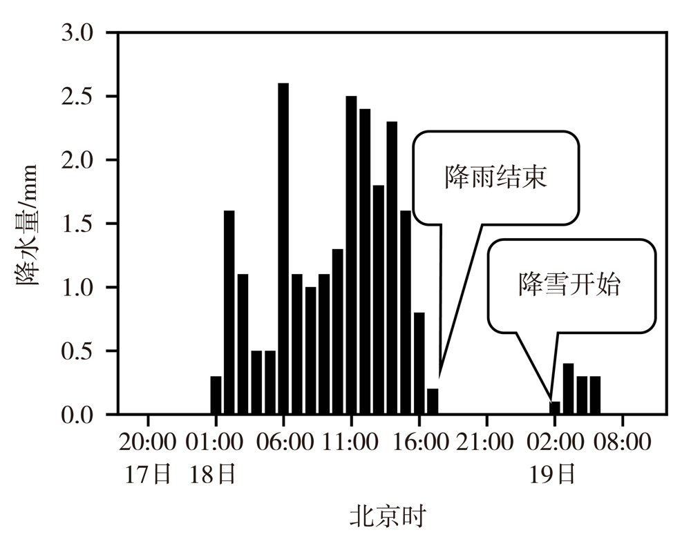
利用ERA5再分析资料及云雷达、微波辐射计和SA双偏振多普勒雷达等多源观测资料,分析2020年11月17—19日张家口地区一次雨雪天气的降水相态演变特征。结果表明:在高空低槽、中低层低涡与地面倒槽配合下,高空槽后西北气流引导冷空气南下造成气温迅速下降,导致降水相态变化。过程前期整层大气均为强暖平流,且地面气温较高,降水相态为雨。18日傍晚冷平流发展强烈,各层温度迅速降低,整层变为冷层,导致降水相态转换为雪。散度和垂直速度的诊断表明降雨时段的动力强迫主要位于高层,降雪时段则主要位于低层。云雷达高分辨率资料可以反映0 ℃层变化,大于10 dBZ的质心变化可以指示降水强度变化,降雨时的基本速度最大可达6~8 m·s-1,而降雪时则小于 2 m·s-1。微波辐射计高分辨率时空资料可以准确判断雨雪转换时间,降水开始之前3~5 h积分水汽含量出现跃升与峰值。双偏振雷达和微波辐射计结合可以对降水粒子相态实现准确判断,可用于降水相态转换的临近预报。

关键词: 降水相态, 0 ℃层, 云雷达, 微波辐射计, SA双偏振多普勒雷达

Abstract:

The phase state of precipitation in winter is relatively complex, and the consistency of transformation forecast between liquid and solid state is a difficulty in the forecast. In order to explore the application of muti-source data in rain-snow phase prediction, the precipitation phase characteristics of a rain-snow weather in Zhangjiakou area from 17 to 19 November 2020 were analyzed based on ERA5 reanalysis data, as well as cloud radar, microwave radiometer and SA dual polarization Doppler radar observation data. The results show that the rain-snow weather occurred under the coordination of upper trough, lower vortex and surface trough, the cold air from northwest behind the upper trough moved southward, which led to a rapid drop of air temperature and the change of precipitation phase. In the early stage of the process, the whole atmosphere was strong warm advection, and the ground temperature was high and the precipitation phase was rain. In the evening of November 18, the cold advection developed strongly, the temperature of each layer decreased rapidly, and the whole layer turned into cold layer, which led to the conversion of precipitation phase to snow. Through the dynamic diagnosis of divergence and vertical velocity, it was shown that the dynamic forcing during the rainfall period was mainly located in the upper layer, while during the snowfall period it was mainly located in the lower layer. The high-resolution data of cloud radar could reflect the change of 0 ℃ layer, and the change of mass center greater than 10 dBZ could indicate the change of precipitation intensity. The maximum basic velocity could reach 6-8 m·s-1 during rainfall stage, while it was less than 2 m·s-1 at snow stage. The high-resolution data of microwave radiometer could accurately judge the time of rain-snow conversion, and it was found that the integral water vapor appeared jump and peak value three to five hours before the precipitation. The combination of dual polarization radar and microwave radiometer could accurately judge the phase of precipitation particles, which could be used in prediction of precipitation phase.

Key words: precipitation phase, 0 ℃ layer, cloud radar, microwave radiometer, SA dual polarization radar

中图分类号: