干旱气象 ›› 2026, Vol. 44 ›› Issue (2): 273-284.DOI: 10.11755/j.issn.1006-7639-2026-02-0273
内蒙古大兴安岭地形对雷击火影响及基于NRBO-XGBoost的扑火因素预测
- 1
内蒙古自治区气候中心 内蒙古 呼和浩特 010051
2太原理工大学软件学院 山西 晋中 030600
3锡林郭勒盟气象局 内蒙古 锡林浩特 026000
-
收稿日期:2026-01-15修回日期:2026-03-22出版日期:2026-05-20发布日期:2026-05-18 -
通讯作者:李钢(1980—),男,博士,副教授,主要研究方向为计算计图像处理。E-mail: tx2090@126.com。
-
作者简介:刘晓东(1981—),男,硕士,正高级工程师,主要从事气象灾害风险研究工作。E-mail: lxd8135@163.com。 -
基金资助:内蒙古自治区重点研发与成果转化计划项目(2025YFDZ0093)
Influence of terrain on lightning-ignited fires and prediction of firefighting factors based on NRBO-XGBoost in the Greater Khingan Mountains of Inner Mongolia
LIU Xiaodong1( ), HUANG Xingang2, LI Gang2(), WANG Guosheng3
- 1
Inner Mongolia Autonomous Region Climate Center Hohhot 010051, China
2College of Software ,Taiyuan University of Technology, Jinzhong 030600 Shanxi, China
3Xilingol League Meteorological Bureau ,Xilinhot 026000 Inner Mongolia, China
-
Received:2026-01-15Revised:2026-03-22Online:2026-05-20Published:2026-05-18
摘要:
为了深化对内蒙古大兴安岭林区雷击火地形影响机制的认识,明确扑火需求的关键驱动因素,基于内蒙古大兴安岭重点国有林区2015—2024年雷击火灾历史数据和高精度地形数据,分析雷击火点在高程、坡度、坡向及地形起伏度等多维地形因子上的空间分布特征,采用基于牛顿-拉夫逊优化器(Newton-Raphson-Based Optimizer,NRBO)优化的XGBoost(eXtreme Gradient Boosting)算法结合SHAP(SHapley Additive exPlanations)方法进行扑火需求建模和分析,揭示过火面积及各地形因子对扑火人数影响的贡献度。结果表明:内蒙古大兴安岭林区雷击火点在高程上呈现“中低海拔集中、高/低海拔稀疏”的梯度特征,83.06%的雷击火灾发生在500~1 000 m的中低海拔区,雷击火点频次最高的区域集中在52.5°N—53.0°N、120.5°E—122.5°E,而过火面积的绝对高值区则出现在更偏南的纬度;雷击火点集中在5°~35°的中坡度区域,[2°,5°)坡度区间过火面积占比高达37.83%;70.97%的雷击火灾发生在[75,200)m的中等起伏地形区域;南坡、西南坡、东南坡等阳坡是雷击火的高风险区;过火面积是预测扑火人数的主导因素,其贡献度明显高于高程、起伏度、坡度和坡向等地形因子,模型预测误差分布呈现显著的“尖峰”形态,且峰值围绕在零误差线附近,模型的测试集预测R2值达0.723 9,且预测区间覆盖概率达84.7%。
中图分类号:
引用本文
刘晓东, 黄薪钢, 李钢, 王国胜. 内蒙古大兴安岭地形对雷击火影响及基于NRBO-XGBoost的扑火因素预测[J]. 干旱气象, 2026, 44(2): 273-284.
LIU Xiaodong, HUANG Xingang, LI Gang, WANG Guosheng. Influence of terrain on lightning-ignited fires and prediction of firefighting factors based on NRBO-XGBoost in the Greater Khingan Mountains of Inner Mongolia[J]. Journal of Arid Meteorology, 2026, 44(2): 273-284.
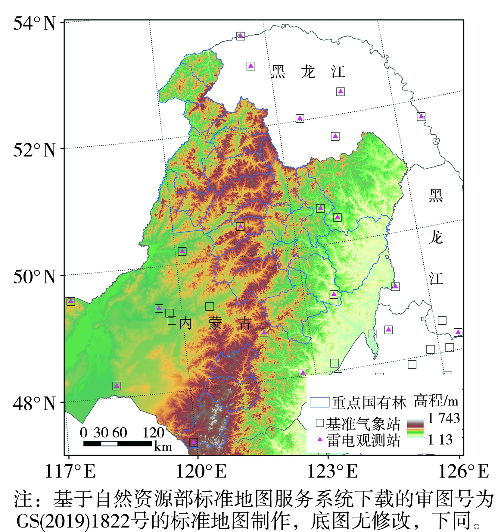
图1 研究区地形及周边气象观测站点分布
Fig.1 Topography of the study area and distribution of surrounding meteorological observation stations
图1 研究区地形及周边气象观测站点分布
Fig.1 Topography of the study area and distribution of surrounding meteorological observation stations
表1 大兴安岭重点国有林区地形因子的分级
Tab.1 Classification of topographic factors in key state-owned forest areas of the Greater Khingan Mountains
| 地形因子 | 分级 | ||||||
|---|---|---|---|---|---|---|---|
| 1 | 2 | 3 | 4 | 5 | 6 | ||
| 高程/m | [200,500) | [500,1 000) | [1 000,1 500) | [1 500,2 000) | |||
| 坡度/(°) | [0,0.5) | [0.5,2) | [2,5) | [5,15) | [15,35) | [35,55) | |
| 地形起伏度/m | [0,20) | [20,75) | [75,200) | [200,600) | |||
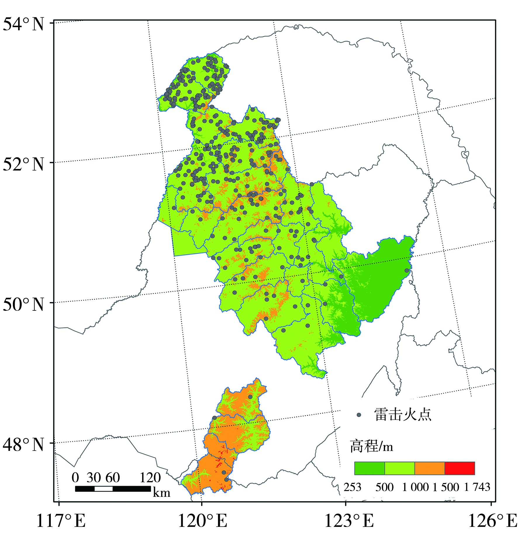
图2 雷击火点在不同高程上的空间分布
Fig.2 Spatial distribution of lightning-ignited fire points at different elevations
图2 雷击火点在不同高程上的空间分布
Fig.2 Spatial distribution of lightning-ignited fire points at different elevations
表2 雷击火灾次数及过火面积在不同高程区间的占比 单位:%
Tab.2 The proportion of lightning-ignited fire occurrences and burned areas in different elevation intervals
| 高程/m | 面积占比 | 雷击火灾次数占比 | 过火面积占比 |
|---|---|---|---|
| [200,500) | 13.80 | 2.69 | 4.02 |
| [500,1 000) | 68.73 | 83.06 | 76.34 |
| [1 000,1 500) | 17.32 | 14.25 | 19.64 |
| [1 500,2 000) | 0.15 | 0 | 0 |
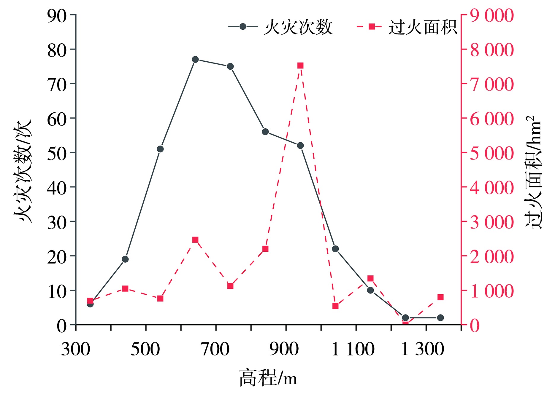
图3 雷击火灾次数和过火面积随高程的变化
Fig.3 The variation of lightning-ignited fire occurrences and burned areas with elevation
图3 雷击火灾次数和过火面积随高程的变化
Fig.3 The variation of lightning-ignited fire occurrences and burned areas with elevation
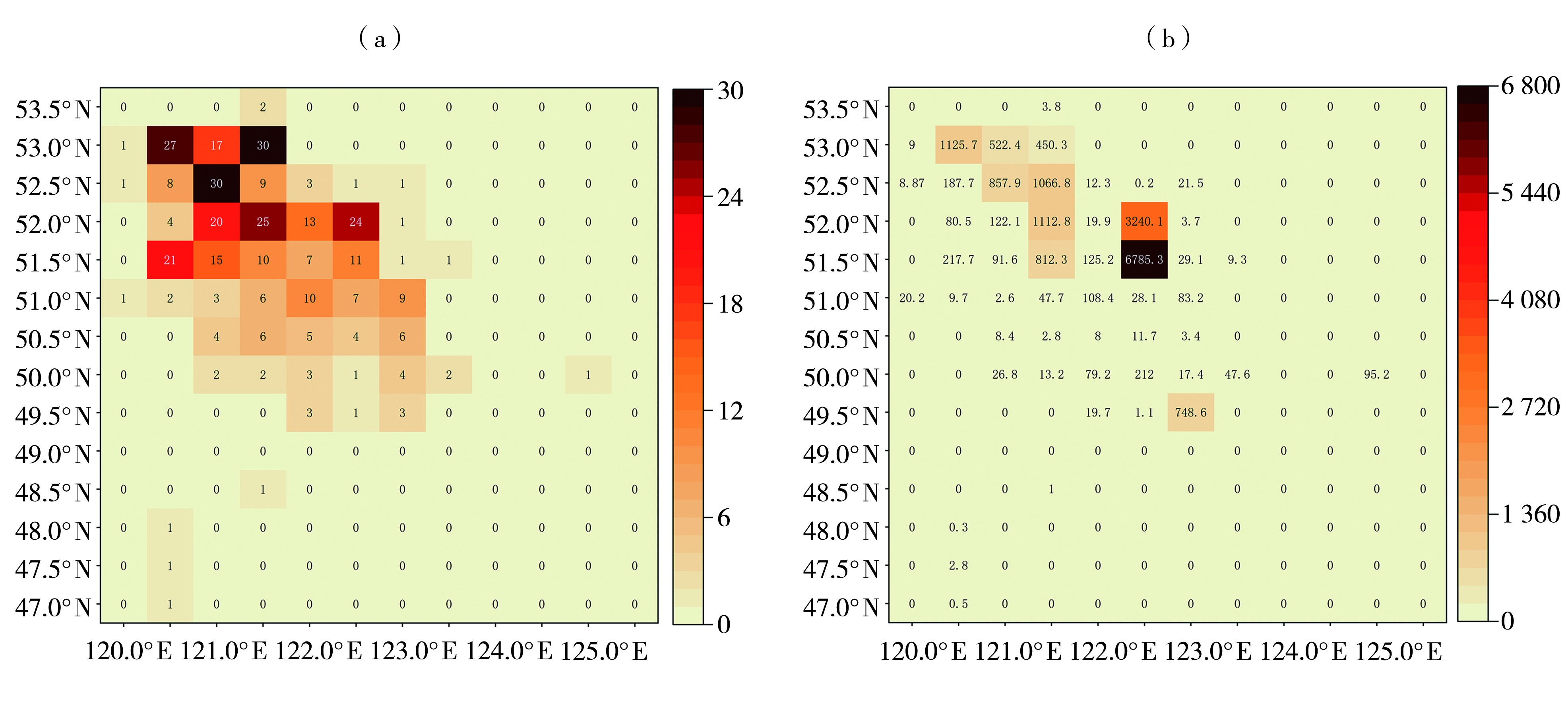
图4 雷击火灾次数(a,单位:次)和过火面积(b,单位:hm2)热力分布图
Fig.4 The heat maps of lightning-ignited fire occurrences (a, Unit: times) and burned areas (b, Unit: hm2)
图4 雷击火灾次数(a,单位:次)和过火面积(b,单位:hm2)热力分布图
Fig.4 The heat maps of lightning-ignited fire occurrences (a, Unit: times) and burned areas (b, Unit: hm2)
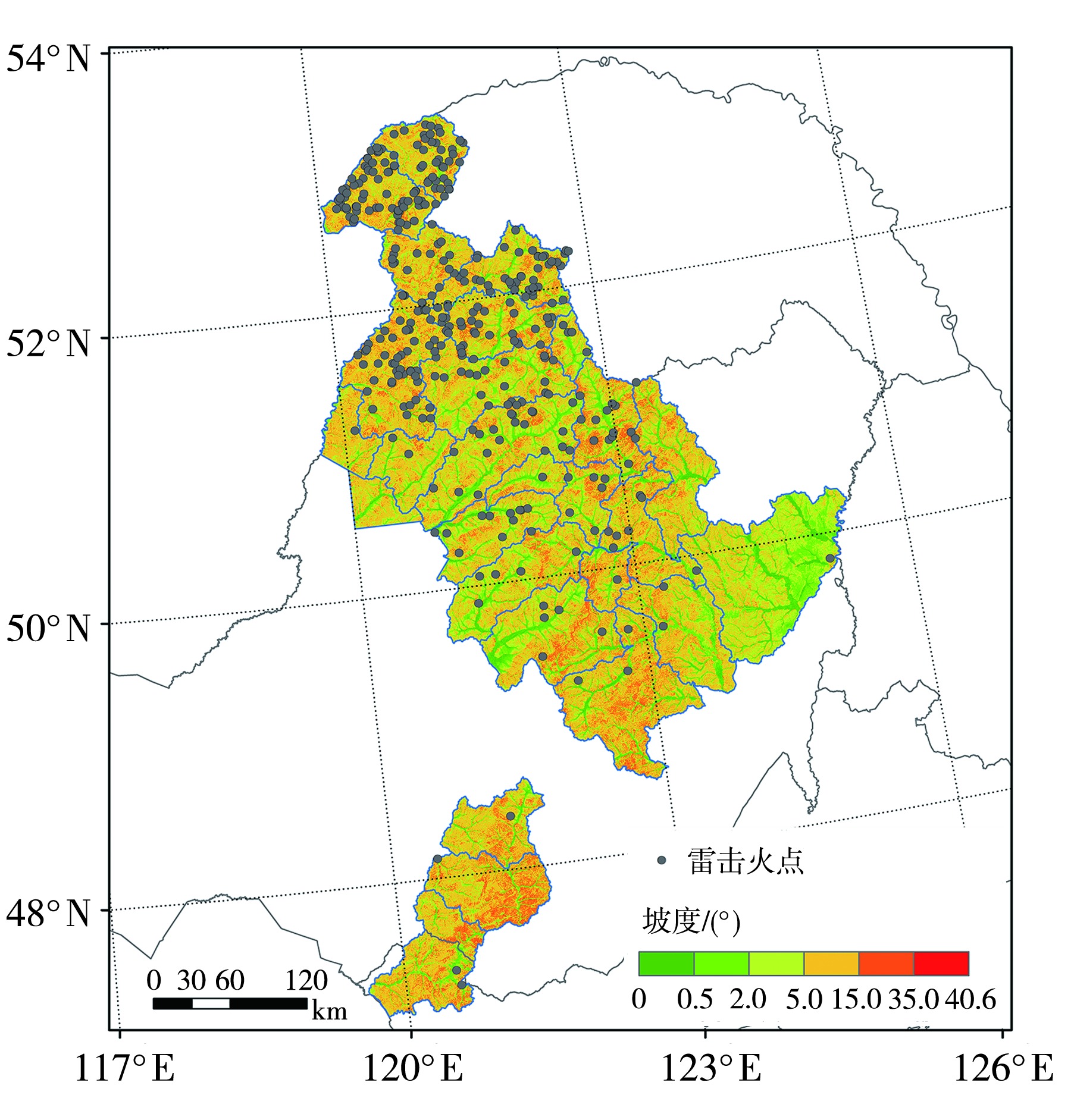
图5 雷击火点在不同坡度上的空间分布
Fig.5 The spatial distribution of lightning-ignited fire points at different slopes
图5 雷击火点在不同坡度上的空间分布
Fig.5 The spatial distribution of lightning-ignited fire points at different slopes
表3 雷击火灾次数及过火面积在不同坡度区间的占比 单位:%
Tab.3 The proportion of lightning-ignited fire occurrences and burned areas in different slope intervals
| 坡度/(°) | 面积占比 | 雷击火灾次数占比 | 过火面积占比 |
|---|---|---|---|
| [0,0.5) | 4.05 | 2.69 | 4.49 |
| [0.5,2.0) | 11.97 | 7.26 | 2.01 |
| [2.0,5.0) | 21.58 | 17.47 | 37.83 |
| [5.0,15.0) | 52.87 | 56.72 | 51.37 |
| [15.0,35.0) | 9.53 | 15.86 | 4.30 |
| [35.0,55.0) | 0 | 0 | 0 |
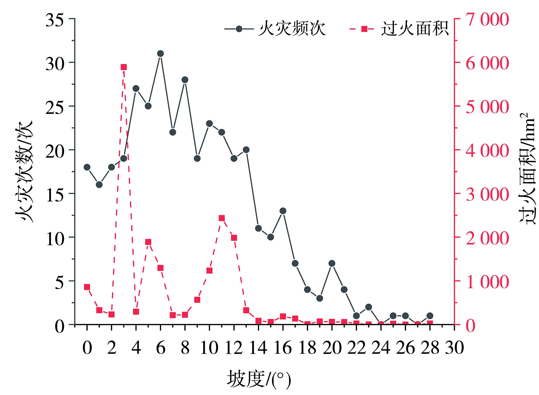
图6 雷击火灾频次和过火面积随坡度的变化
Fig.6 The change of lightning-ignited fire occurrences and burned areas with slope
图6 雷击火灾频次和过火面积随坡度的变化
Fig.6 The change of lightning-ignited fire occurrences and burned areas with slope

图7 雷击火点在不同地形起伏度上的空间分布
Fig.7 The spatial distribution of lightning-ignited fire points on different terrain relief degrees
图7 雷击火点在不同地形起伏度上的空间分布
Fig.7 The spatial distribution of lightning-ignited fire points on different terrain relief degrees
表4 雷击火灾次数及过火面积在不同地形起伏度区间上的占比 单位:%
Tab.4 The proportion of lightning-ignited fire occurrences and burned areas across different topographic relief degree intervals
| 地形起伏度/m | 面积占比 | 雷击火灾次数占比 | 过火面积占比 |
|---|---|---|---|
| [0,20) | 7.96 | 5.65 | 2.14 |
| [20,75) | 30.45 | 19.62 | 38.48 |
| [75,200) | 59.41 | 70.97 | 47.67 |
| [200,600) | 2.18 | 3.76 | 11.71 |
图8 雷击火灾次数和过火面积随地形起伏度的变化
Fig.8 The variation of the number of lightning-ignited fires and burned area with terrain relief degree
图8 雷击火灾次数和过火面积随地形起伏度的变化
Fig.8 The variation of the number of lightning-ignited fires and burned area with terrain relief degree

图9 雷击火点在不同坡向上的空间分布
Fig.9 The spatial distribution of lightning-ignited fire points on different slope aspects
图9 雷击火点在不同坡向上的空间分布
Fig.9 The spatial distribution of lightning-ignited fire points on different slope aspects
表5 雷击火灾次数及过火面积在不同坡向上的占比 单位:%
Tab.5 The proportion of the number of lightning-ignited fires and burned area on different slope aspects
| 坡向 | 面积占比 | 雷击火灾次数占比 | 过火面积占比 |
|---|---|---|---|
| 平地 | 0.59 | 0 | 0 |
| 北坡 | 11.37 | 5.65 | 16.20 |
| 东北坡 | 13.06 | 11.56 | 5.34 |
| 东坡 | 13.49 | 11.83 | 11.35 |
| 东南坡 | 12.50 | 15.59 | 11.53 |
| 南坡 | 11.78 | 16.67 | 4.81 |
| 西南坡 | 12.48 | 15.86 | 6.99 |
| 西坡 | 12.71 | 13.17 | 30.08 |
| 西北坡 | 12.03 | 9.68 | 13.69 |
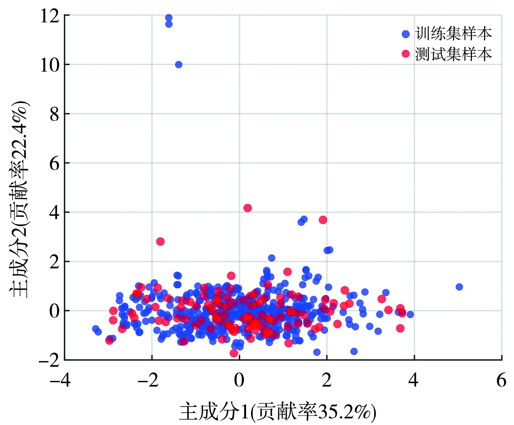
图10 样本数据主成分分析
Fig.10 The principal component analysis of sample data
图10 样本数据主成分分析
Fig.10 The principal component analysis of sample data
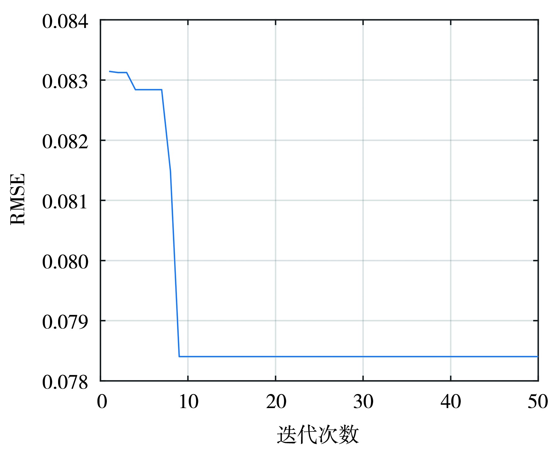
图11 寻优迭代曲线
Fig.11 The optimization iteration curve
图11 寻优迭代曲线
Fig.11 The optimization iteration curve
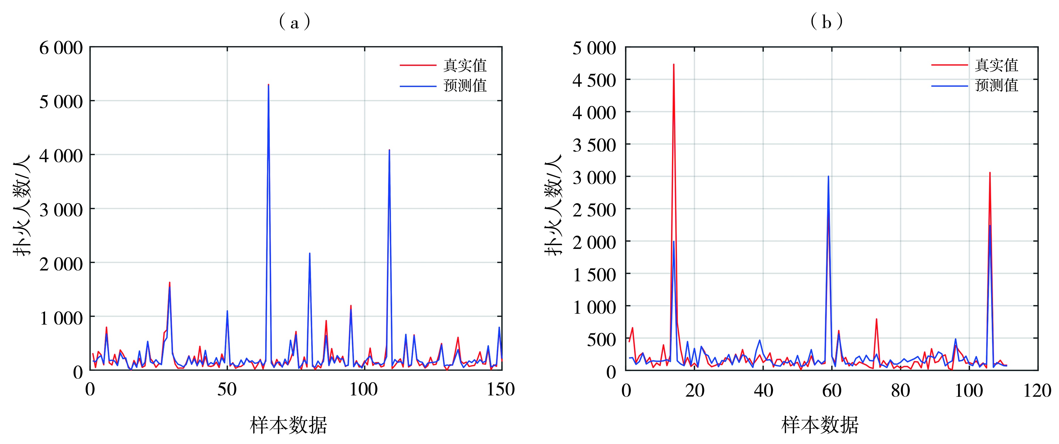
图12 训练集(a)和测试集(b)模型预测结果
Fig.12 The prediction results of the model for the training set (a) and the test set (b)
图12 训练集(a)和测试集(b)模型预测结果
Fig.12 The prediction results of the model for the training set (a) and the test set (b)
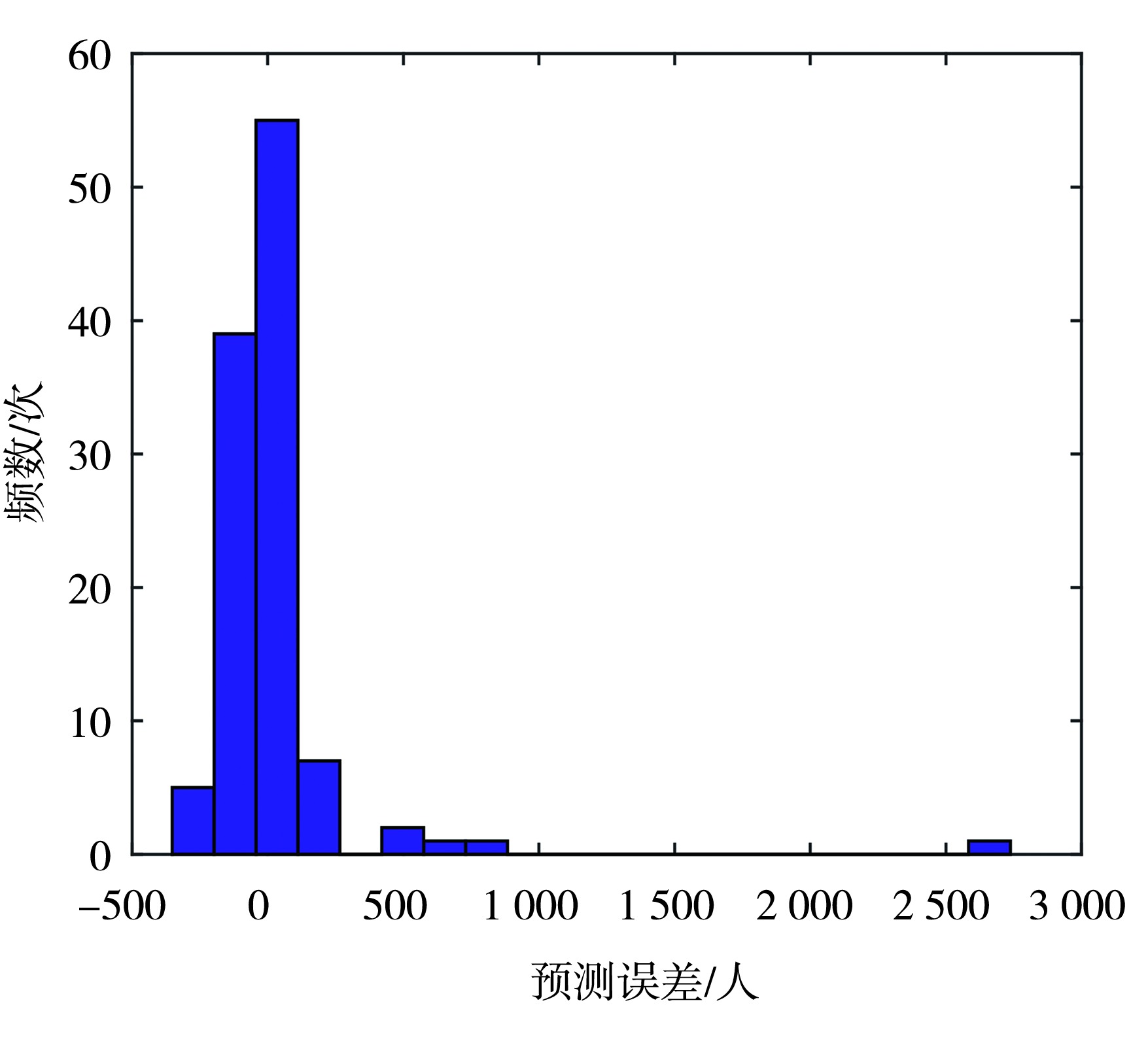
图13 测试集预测误差直方图
Fig.13 The histogram of prediction errors on the test set
图13 测试集预测误差直方图
Fig.13 The histogram of prediction errors on the test set
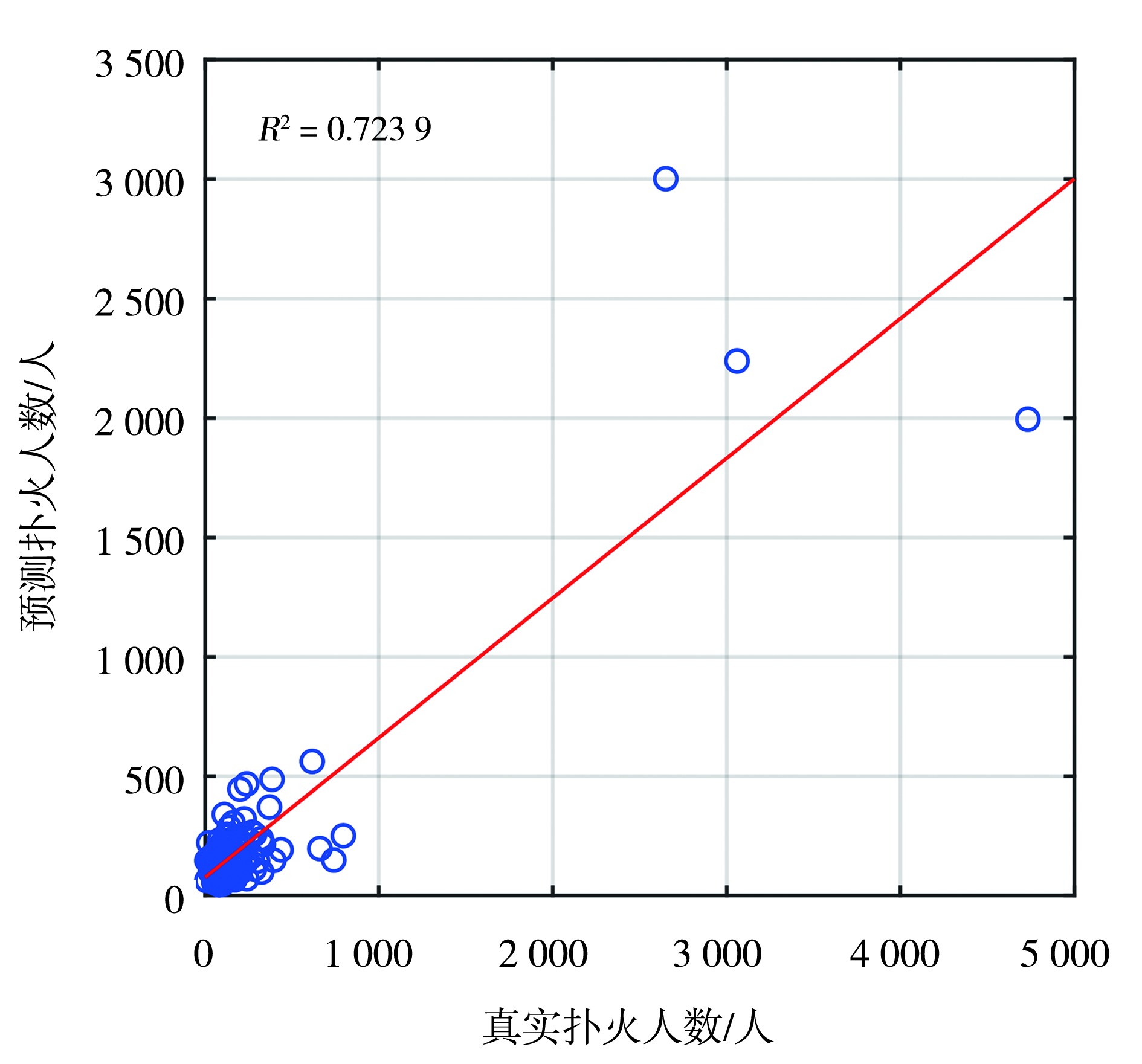
图14 测试集预测R2图
Fig.14 The R2plot of predictions on the test set
图14 测试集预测R2图
Fig.14 The R2plot of predictions on the test set
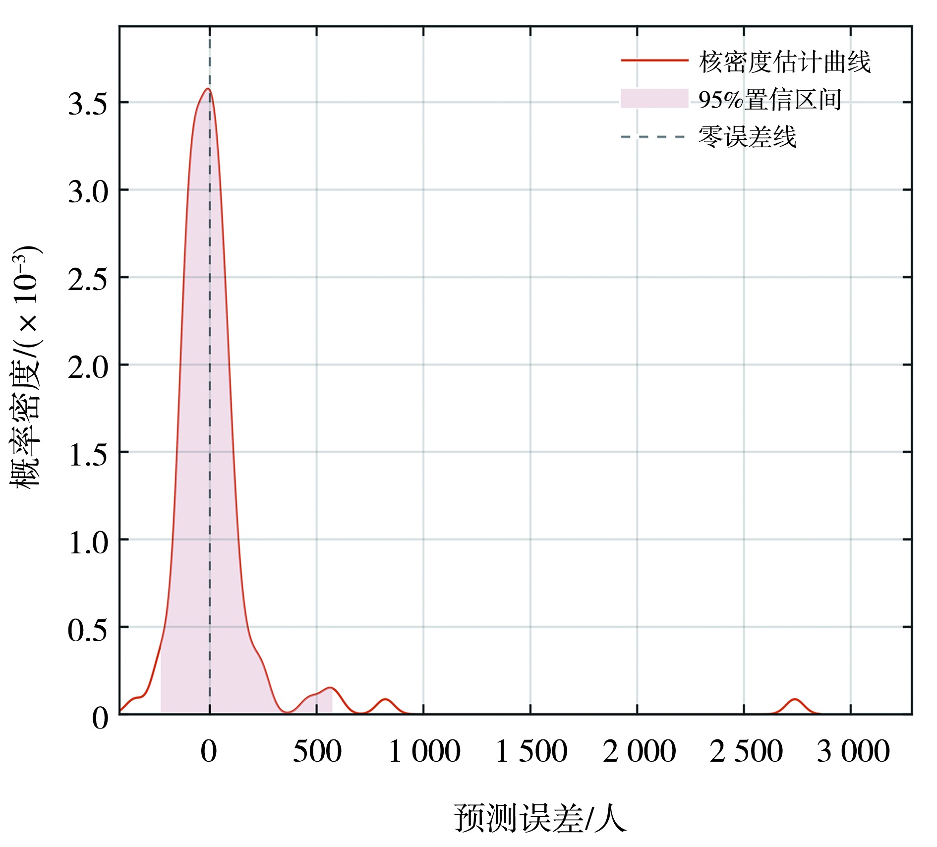
图15 区间预测的核密度估计曲线
Fig.15 The kernel density estimation curve of interval prediction
图15 区间预测的核密度估计曲线
Fig.15 The kernel density estimation curve of interval prediction
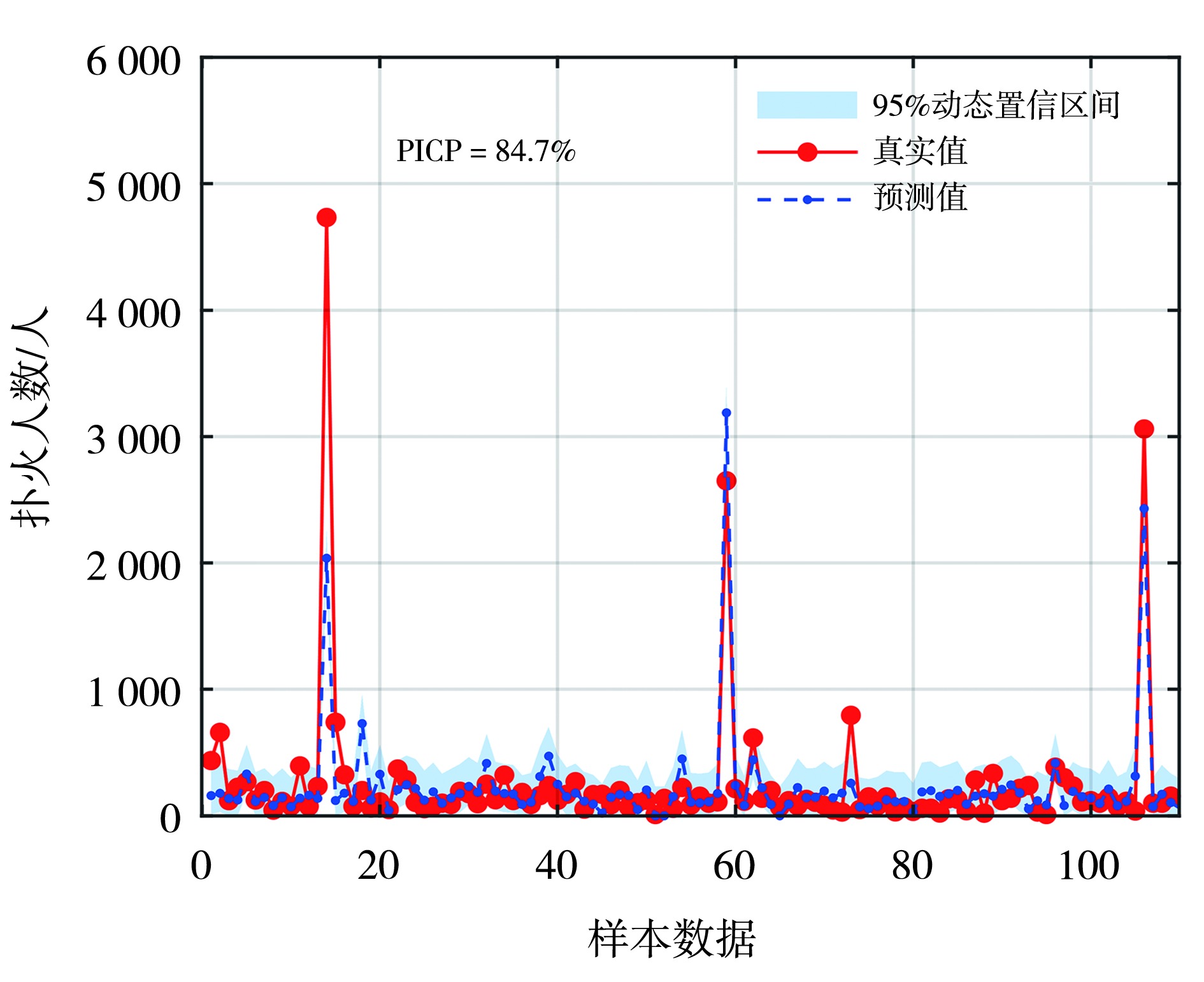
图16 区间预测结果
Fig.16 The interval prediction results
图16 区间预测结果
Fig.16 The interval prediction results
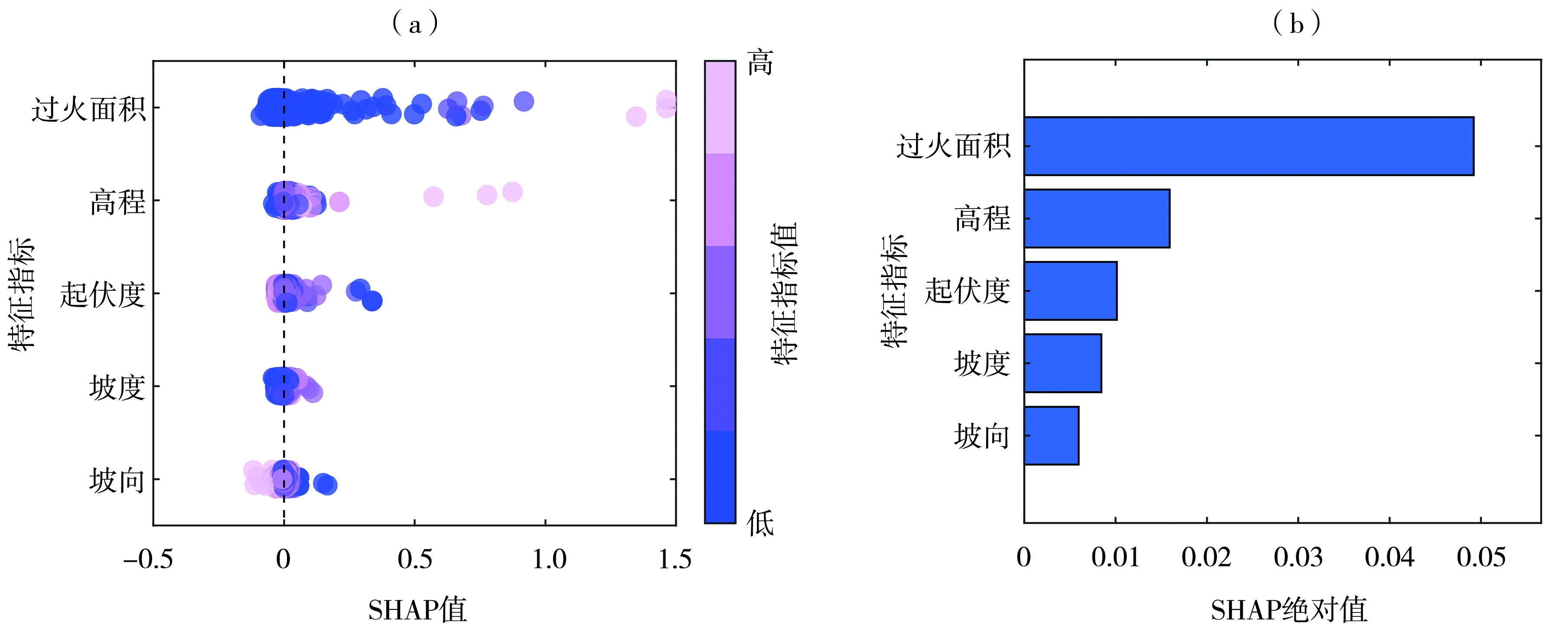
图17 扑火影响因素SHAP值分布(a)及重要性排序(b)
Fig.17 The SHAP value distribution (a) and importance ranking (b) of wildfire suppression influencing factors
图17 扑火影响因素SHAP值分布(a)及重要性排序(b)
Fig.17 The SHAP value distribution (a) and importance ranking (b) of wildfire suppression influencing factors
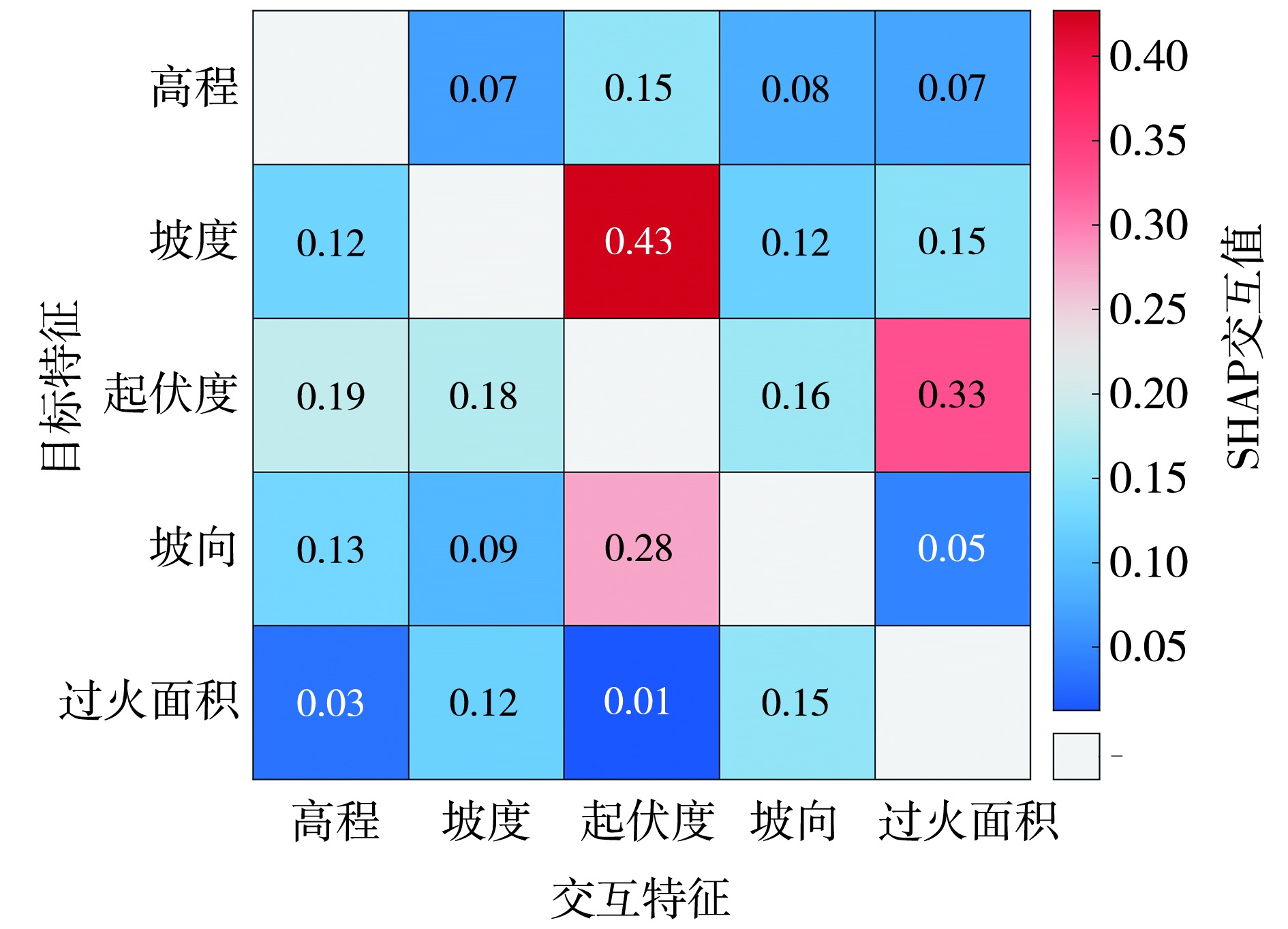
图18 扑火影响因素全局SHAP 特征交互矩阵
Fig.18 Global SHAP feature interaction matrix for wildfire suppression influencing factors
图18 扑火影响因素全局SHAP 特征交互矩阵
Fig.18 Global SHAP feature interaction matrix for wildfire suppression influencing factors
| [1] | 毕杰和, 2018. 内蒙古大兴安岭林区森林生态状况及保护建议[J]. 内蒙古林业调查设计, 41(6):6-8. |
| [2] | 焦强英, 韩宗甫, 王炜烨, 等, 2023. 基于多源数据和机器学习方法的大兴安岭地区雷击火驱动因子及火险预测模型[J]. 林业科学, 59(6):74-87. |
| [3] | 李婧, 2022. 内蒙古大兴安岭林火时空分布及火险区划[D]. 呼和浩特: 内蒙古农业大学. |
| [4] | 李威, 舒立福, 王明玉, 等, 2023. 大兴安岭1980—2021年雷击火时空分布特征[J]. 林业科学, 59(10):22-31. |
| [5] | 刘爱利, 2004. 基于1:100万DEM的我国地形地貌特征研究[D]. 西安: 西北大学. |
| [6] | 刘晓东, 冯旭宇, 李庆君, 等, 2021. 内蒙古地形因素对雷电灾害的影响及其权重分析[J]. 科学技术与工程, 21(3):899-905. |
| [7] | 刘晓东, 冯旭宇, 刘旭洋, 等, 2020. 内蒙古雷击人员伤亡特征及其致灾因素的熵权分析[J]. 中国安全生产科学技术, 16(4):182-188. |
| [8] | 倪长虹, 邸雪颖, 2009. 黑龙江省大兴安岭雷击火发生规律[J]. 东北林业大学学报, 37(1):55-57. |
| [9] |
聂卉, 吴晓燕, 2024. 结合梯度提升树算法与可解释机器学习模型SHAP的抑郁症影响因素研究[J]. 数据分析与知识发现, 8(3):41-52.
DOI |
| [10] | 田晓瑞, 舒立福, 王明玉, 等, 2009. 大兴安岭雷击火时空分布及预报模型[J]. 林业科学研究, 22(1):14-20. |
| [11] | 田晓瑞, 舒立福, 赵凤君, 等, 2012. 大兴安岭雷击火发生条件分析[J]. 林业科学, 48(7):98-103. |
| [12] | 万雨勤, 仝纪龙, 刘永乐, 等, 2026. 基于XGBoost算法量化气象要素对兰州市主城区夏季臭氧浓度的影响[J]. 环境科学, 47(1):223-232. |
| [13] | 杨腾杰, 高新强, 杨志国, 等, 2025. 基于NRBO-XGBoost和ABKDE融合可解释模型的TBM掘进速度预测[J]. 河南科技大学学报:自然科学版, 46(4):73-87. |
| [14] | 岳永杰, 韩军, 李玉柱, 等, 2013. 内蒙古大兴安岭森林涵养水源和保育土壤功能评估[J]. 中南林业科技大学学报, 33(12):91-95. |
| [15] | 张冬有, 邓欧, 李亦秋, 等, 2012. 黑龙江省1980—2005年森林火灾时空特征[J]. 林业科学, 48(2):175-179. |
| [16] | 赵凤君, 舒立福, 邸雪颖, 等, 2009. 气候变暖背景下内蒙古大兴安岭林区森林火灾发生日期的变化[J]. 林业科学, 45(6):166-172. |
| [17] | 赵俊卉, 郭广猛, 亢新刚, 等, 2008. 基于LIS/OTD格点数据的中国东北地区雷击火时空分布原因分析[J]. 内蒙古农业大学学报:自然科学版, 29(3):49-54. |
| [18] | 赵俊卉, 亢新刚, 郭广猛, 等, 2009. 基于LIS/OTD格点数据的中国东北地区雷击火时空分布[J]. 生态学杂志, 28(4): 715-720. |
| [19] | 周梅, 2003. 大兴安岭落叶松林生态系统水文过程与规律研究[D]. 北京: 北京林业大学. |
| [20] | ABATZOGLOU J T, WILLIAMS A P, 2016. Impact of anthropogenic climate change on wildfire across western US forests[J]. Proceedings of the National Academy of Sciences of the United States of America, 113(42): 11 770-11 775. |
| [21] |
BOWMAN D M J S, BALCH J K, ARTAXO P, et al, 2009. Fire in the Earth system[J]. Science, 324(5926): 481-484.
DOI PMID |
| [22] | CHEN F, DU Y S, NIU S K, et al, 2015. Modeling forest lightning fire occurrence in the Daxinganling Mountains of northeastern China with MAXENT[J]. Forests, 6(5): 1 422-1 438. |
| [23] |
COCHRANE M A, MORAN C J, WIMBERLY M C, et al, 2012. Estimation of wildfire size and risk changes due to fuels treatments[J]. International Journal of Wildland Fire, 21(4): 357-367.
DOI URL |
| [24] | DU Y, LI S, FENG P, et al, 2021. Dynamic risk assessment of wildfire based on integrating multi-source data and a random forest algorithm: A case study of Chongqing, China[J]. Natural Hazards, 108(1): 1 071-1 090. |
| [25] |
GUO F T, WANG G Y, INNES L, et al, 2016. Comparison of six generalized linear models for occurrence of lightning-induced fires in northern Daxing’an Mountains, China[J]. Journal of Forestry Research, 27(2): 379-388.
DOI URL |
| [26] |
HEYERDAHL E K, BRUBAKER L B, AGEE J K, 2001. Spatial controls of historical fire regimes: A multiscale example from the interior west, USA[J]. Ecology, 82(3): 660-678.
DOI URL |
| [27] |
JAIN P, COOGAN S C P, SUBRAM-ANIAN S G, et al, 2020. A review of machine learning applications in wildfire science and management[J]. Environmental Reviews, 28(4): 478-505.
DOI URL |
| [28] |
JOLLY W M, COCHRANE M A, FREEBORN P H, et al, 2015. Climate-induced variations in global wildfire danger from 1979 to 2013[J]. Nature Communications, 6: 7537. DOI: 10.1038/ncomms7537.
PMID |
| [29] |
LUNDBERG S M, ERION G, CHEN H, et al, 2020. From local explanations to global understanding with explainable AI for trees[J]. Nature Machine Intelligence, 2(1): 56-67.
DOI PMID |
| [30] | NARAYANARAJ G, WIMMERS M T, 2012. Modeling the influence of topographic roughness on fire spread[J]. Environmental Modelling & Software, 38: 290-302. |
| [31] | PARKS S A, PARISIEN M A, MILLER C, 2012. Spatial bottom-up controls on fire likelihood vary across western North America[J]. Ecosphere, 3(1): 1-20. |
| [32] |
RODRIGUES M, DE LA RIVA J, FOTHERINGHAM S, 2014. Modeling the spatial variation of the explanatory factors of human-caused wildfires in Spain using geographically weighted logistic regression[J]. Applied Geography, 48: 52-63.
DOI URL |
| [33] | ROTHERMEL R C, 1972. A mathematical model for predicting fire spread in wildland fuels[R]. Ogden: USDA Forest Service, Intermountain Forest and Range Experiment Station, 1-52. |
| [34] |
RUDIN C, 2019. Stop explaining black box machine learning models for high stakes decisions and use interpretable models instead[J]. Nature Machine Intelligence, 1(5): 206-215.
DOI PMID |
| [35] | SONG S D, ZHOU X, YUAN S B, et al, 2025. Interpretable artificial intelligence models for predicting lightning prone to inducing forest fires[J]. Journal of Atmospheric and Solar-Terrestrial Physics, 267: 106408. DOI:10.1016/j.jastp.2024.106408. |
| [36] | SOWMYA R, PREMKUMAR M, JANGIR P, 2024. Newton-Raphson-based optimizer: A new population-based metaheuristic algorithm for continuous optimization problems[J]. Engineering Applications of Artificial Intelligence, 128:107532. DOI:1016/j.engappai.2023.107532. |
| [37] |
SYPHARD A D, RADELOFF V C, KEULER N S, et al, 2008. Predicting spatial patterns of fire on a southern California landscape[J]. International Journal of Wildland Fire, 17(5): 602-613.
DOI URL |
| [38] | YUE W T, REN C, LIANG Y J, et al, 2023. Assessment of wildfire susceptibility and wildfire threats to ecological environment and urban development based on GIS and multi-source data: A case study of Guilin, China[J]. Remote Sensing, 15(10): 2659. DOI:10.3390/rs15102659. |
| [1] | 汤浩, 周雅蔓, 安大维, 王敏仲. 天山峡谷北缘一次极端下坡风暴三维结构及触发机理分析[J]. 干旱气象, 2026, 44(2): 241-253. |
| [2] | 莫欣妍, 梁旭东. 华北“23·7”极端降水数值预报误差特征及主要影响因素分析[J]. 干旱气象, 2026, 44(1): 126-137. |
| [3] | 崔慧慧, 李荣, 孙存永. 郑州短时强降水精细时空分布特征及地形影响[J]. 干旱气象, 2025, 43(6): 920-930. |
| [4] | 任丽, 卜文惠, 于震宇, 白俊杰, 李瑶. 一次伴有极端降水的东北冷涡过程分析[J]. 干旱气象, 2025, 43(6): 939-952. |
| [5] | 陶涛, 舒志亮, 邓佩云, 何佳, 巴音那木拉, 常倬林. 六盘山一次积层混合地形云宏微观特征观测分析[J]. 干旱气象, 2025, 43(2): 277-288. |
| [6] | 邓佩云, 常倬林, 何佳, 杨萌, 陈得圆, 林彤, 穆建华, 戴言博. 六盘山地区大气水汽的时空差异与驱动因子分析[J]. 干旱气象, 2024, 42(3): 376-384. |
| [7] | 段婧, 王新, 陈勇, 郭强, 王田田, 陈添宇, 陈宝君. 祁连山中段夏季降雨与对流特征分析[J]. 干旱气象, 2024, 42(3): 405-414. |
| [8] | 黄晓龙, 吴薇, 徐晓莉, 王丽伟, 宋云帆, 李雪. 基于地形起伏度的四川省地面气象站点适宜性研究[J]. 干旱气象, 2023, 41(4): 579-588. |
| [9] | 唐永兰, 徐桂荣, 王晓芳, 肖艳姣, 祁海霞, 冷亮. 1992—2021年三峡库区夏季小时强降水时空分布特征[J]. 干旱气象, 2023, 41(4): 589-598. |
| [10] | 杨丽杰, 曹彦超, 刘维成, 徐丽丽, 张洪芬, 孙子茱. 陇东黄土高原旱区短时强降水的时空分布特征及地形影响研究[J]. 干旱气象, 2022, 40(6): 945-953. |
| [11] | 魏华兵, 陈正洪, 罗翔, 肖运, 罗昱, 张鹏. 基于GIS的鄂东南枇杷种植生态适宜性精细化区划[J]. 干旱气象, 2022, 40(5): 823-830. |
| [12] | 裴坤宁, 王雁, 闫世明, 蒋云盛, 郭伟. 地形和天气形势对临汾市大气污染的影响[J]. 干旱气象, 2022, 40(5): 879-887. |
| [13] | 马思敏, 穆建华, 舒志亮, 孙艳桥, 邓佩云, 周楠. 六盘山区一次典型暴雨过程的地形敏感性模拟试验[J]. 干旱气象, 2022, 40(3): 457-468. |
| [14] | 张桂莲, 刘澜波, 孟雪峰, 张璐, 李林惠. 冷垫背景下回流暴雪成因与雷达回波特征分析[J]. 干旱气象, 2022, 40(3): 500-506. |
| [15] | 钱勇, 邱贵强, 张华明, 李强, 崔蕾, 李云飞. 多源气象资料在森林雷击火辨识中的应用[J]. 干旱气象, 2022, 40(3): 536-543. |
| 阅读次数 | ||||||
|
全文 |
|
|||||
|
摘要 |
|
|||||
