干旱气象 ›› 2026, Vol. 44 ›› Issue (2): 208-218.DOI: 10.11755/j.issn.1006-7639-2026-02-0208
基于多源数据的典型干旱区云水资源气候特征研究
李卓卓1,2( ), 杨莲梅2(), 阿不都外力·阿不力克木1
- 1
新疆大学地理与遥感科学学院 新疆 乌鲁木齐 830017
2中国气象局乌鲁木齐沙漠气象研究所 新疆 乌鲁木齐 830002
-
收稿日期:2025-06-30修回日期:2026-02-21出版日期:2026-05-20发布日期:2026-05-18 -
通讯作者:杨莲梅(1969—),女,研究员,主要从事天气气候和云降水物理研究。E-mail: yanglm@idm.cn。
-
作者简介:李卓卓(2002—),女,主要从事云水资源研究。E-mail: 577902017@qq.com。 -
基金资助:新疆维吾尔自治区重点研发计划项目(2023B03019-1);天山英才培养计划领军人才项目(2022TSYCLJ0003)
A study on the climatic characteristics of cloud water resources in typical arid areas based on multiple datasets
LI Zhuozhuo1,2(), YANG Lianmei2(), Abulikemu Abuduwaili1
- 1
College of Geography and Remote Sensing Sciences ,Xinjiang University Urumqi 830017, China
2Institute of Desert Meteorology ,China Meteorological Administration Urumqi 830002, China
-
Received:2025-06-30Revised:2026-02-21Online:2026-05-20Published:2026-05-18
摘要:
为揭示新疆云水资源的时空分布特征,基于2007—2019年CloudSat和MODIS卫星资料和1979—2024年ERA5再分析资料,系统分析了新疆地区云量及云水参数(云水含量、云液水含量和云冰水含量)的变化特征。结果表明,3种资料均能刻画出新疆云水参数山区高、盆地低的主要空间分布特征,且冰水含量整体高于液水含量。ERA5空间分辨率较高,能够更清晰反映局地地形相关特征;MODIS与ERA5的空间分布一致性较好,但其云水含量存在系统性偏大;CloudSat的空间分布特征在局部区域存在差异,但整体数值与ERA5较为接近。云水含量夏季高、冬季低,春秋季为过渡阶段,各季节冰水含量普遍高于液水含量。1979—2024年北疆盆地和南疆盆地北部云量及云水含量呈显著减少趋势,而昆仑山中东部地区云水含量呈显著增加趋势。
中图分类号:
引用本文
李卓卓, 杨莲梅, 阿不都外力·阿不力克木. 基于多源数据的典型干旱区云水资源气候特征研究[J]. 干旱气象, 2026, 44(2): 208-218.
LI Zhuozhuo, YANG Lianmei, Abulikemu Abuduwaili. A study on the climatic characteristics of cloud water resources in typical arid areas based on multiple datasets[J]. Journal of Arid Meteorology, 2026, 44(2): 208-218.
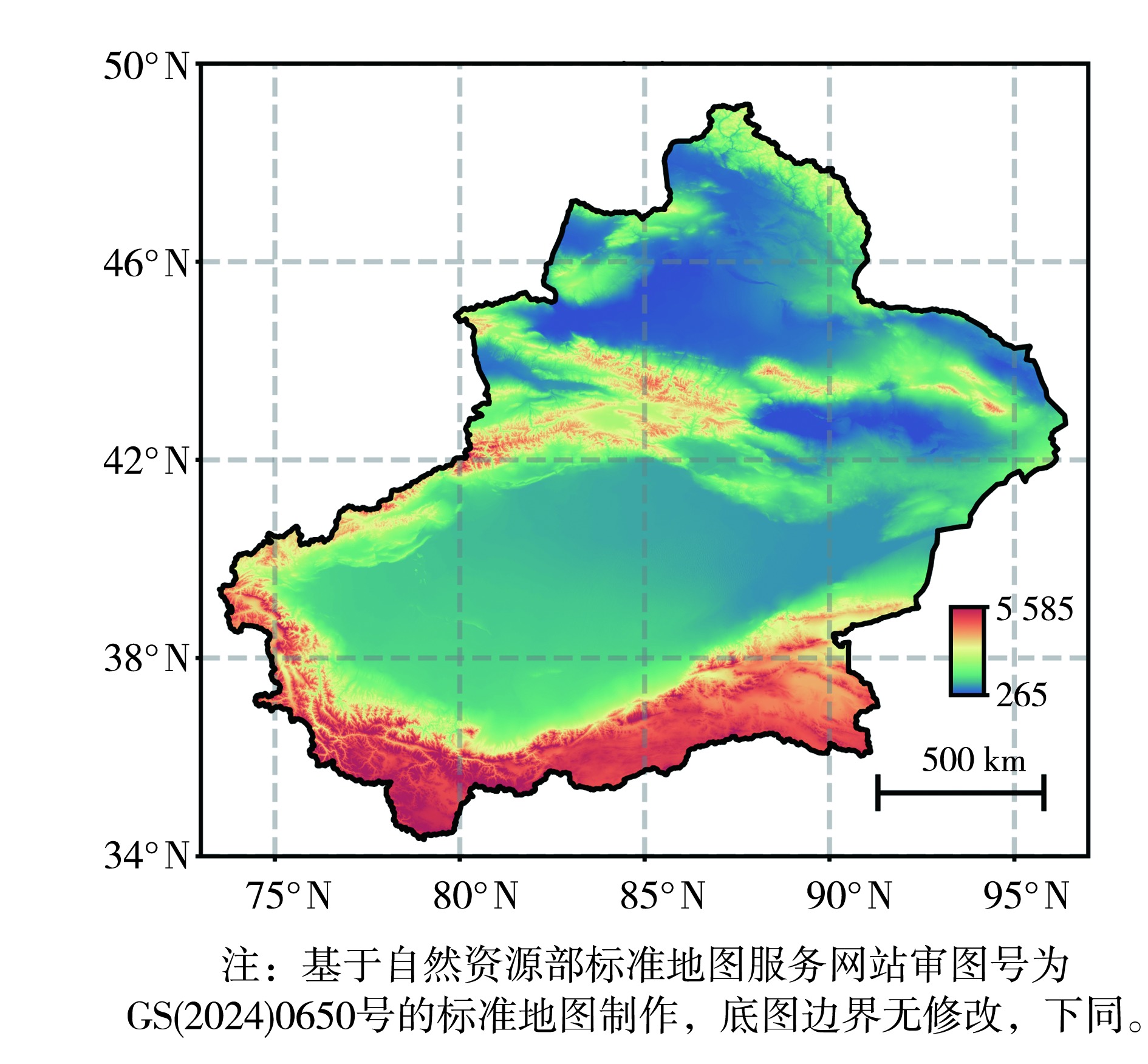
图1 新疆地形
Fig.1 Topography of Xinjiang
图1 新疆地形
Fig.1 Topography of Xinjiang
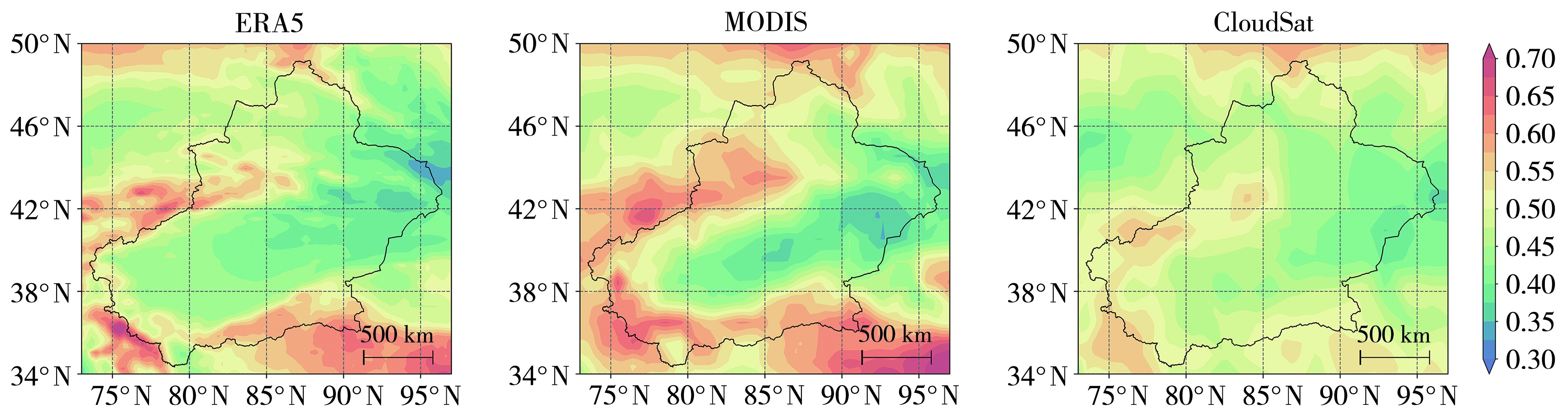
图2 新疆2007—2019年ERA5、MODIS及CloudSat反演的云量多年平均空间分布
Fig.2 Spatial distribution of the mean cloud cover retrieved from ERA5, MODIS and CloudSat over Xinjiang during 2007-2019
图2 新疆2007—2019年ERA5、MODIS及CloudSat反演的云量多年平均空间分布
Fig.2 Spatial distribution of the mean cloud cover retrieved from ERA5, MODIS and CloudSat over Xinjiang during 2007-2019
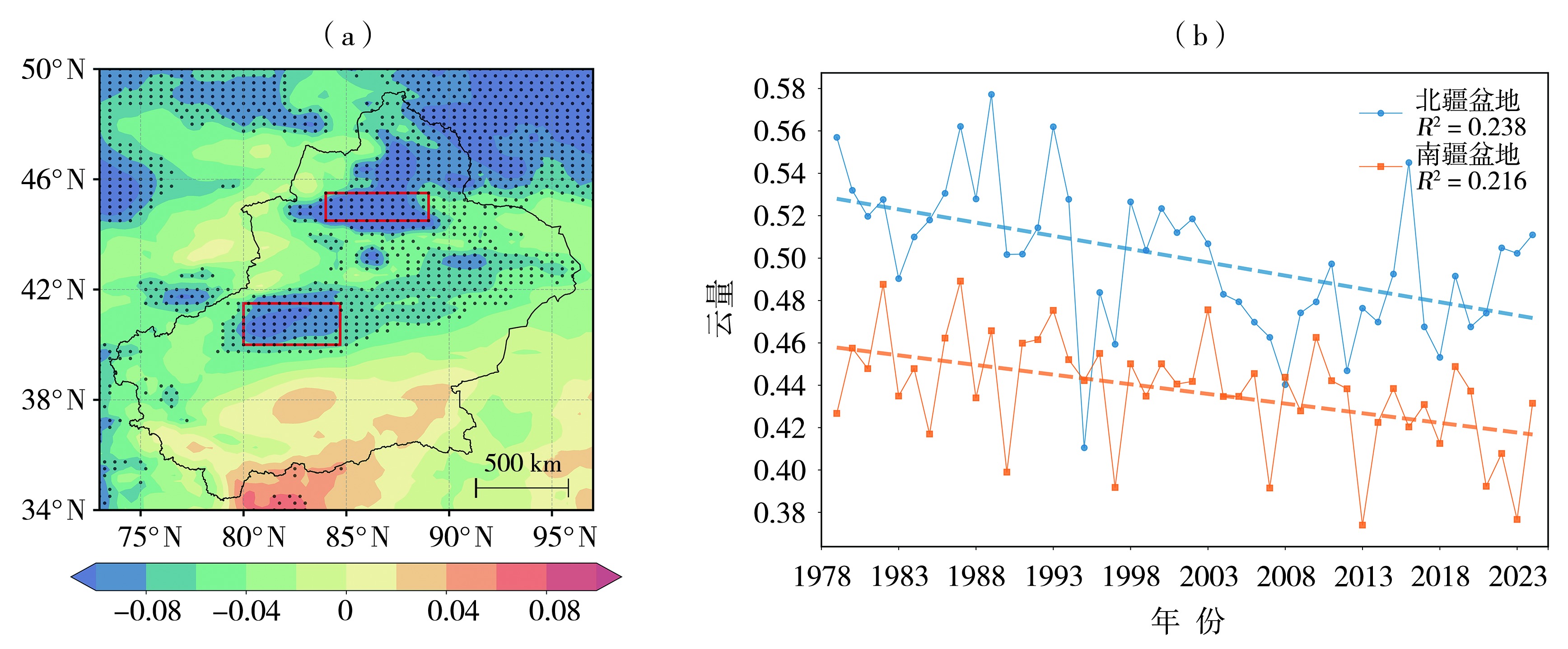
图3 1979-2024年新疆云量年变化趋势空间分布(a,单位:%·a-1)及南北疆盆地平均云量的年际变化(b) (黑色打点区域通过置信水平为95%的显著性检验,下同;红色矩形分别为南北疆盆地)
Fig.3 Spatial distribution of the annual trend of cloud cover over Xinjiang from 1979 to 2024 (a, Unit: %·a-1), and the interannual variation of mean cloud cover over the basins of northern and southern Xinjiang (b) (The black dots area indicate passing the significance test at 95% confidence level, the same as below; the red rectangles represent the basins of northern and southern Xinjiang, respectively)
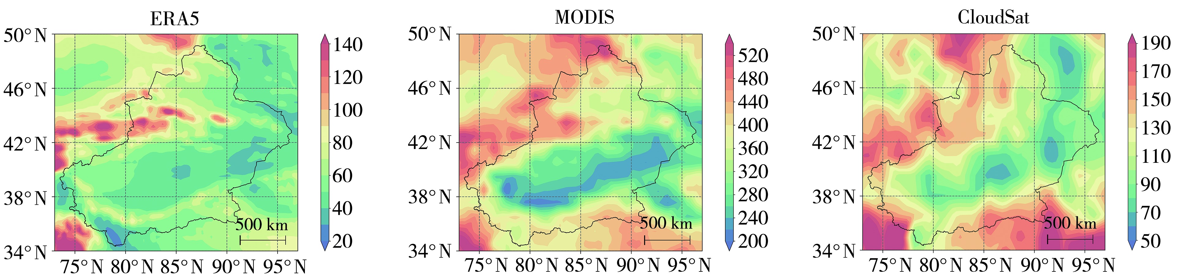
图4 新疆2007—2019年ERA5、MODIS及CloudSat反演的云水含量多年平均空间分布(单位:g·m-2)
Fig.4 Spatial distribution of the mean cloud water content retrieved from ERA5, MODIS and CloudSat over Xinjiang during 2007-2019 (Unit: g·m-2)
图4 新疆2007—2019年ERA5、MODIS及CloudSat反演的云水含量多年平均空间分布(单位:g·m-2)
Fig.4 Spatial distribution of the mean cloud water content retrieved from ERA5, MODIS and CloudSat over Xinjiang during 2007-2019 (Unit: g·m-2)
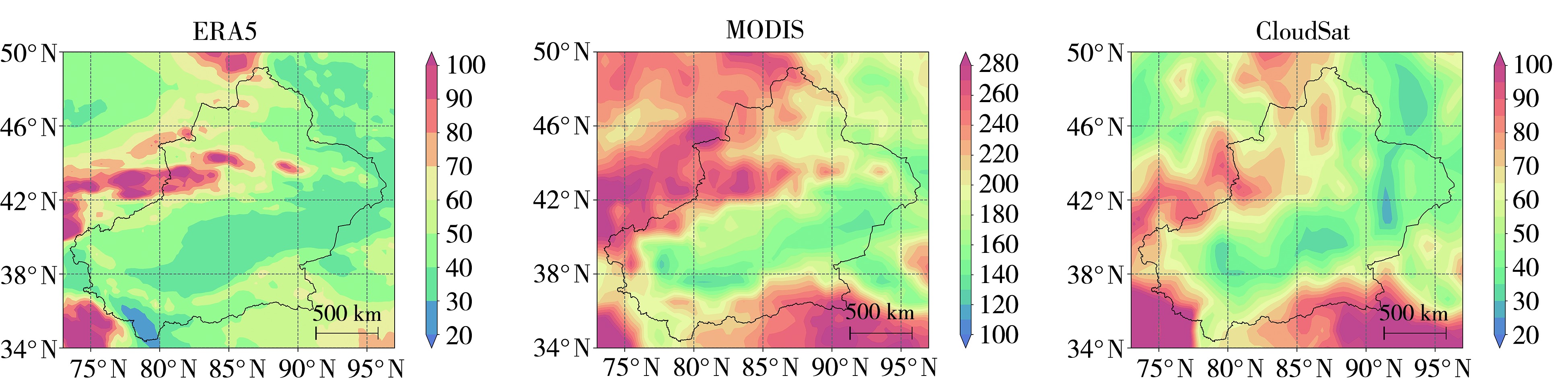
图5 新疆2007-2019年ERA5、MODIS及CloudSat反演的冰水含量多年平均空间分布(单位:g·m-2)
Fig.5 Spatial distribution of the mean ice water content retrieved from ERA5, MODIS and CloudSat over Xinjiang during 2007-2019 (Unit: g·m-2)
图5 新疆2007-2019年ERA5、MODIS及CloudSat反演的冰水含量多年平均空间分布(单位:g·m-2)
Fig.5 Spatial distribution of the mean ice water content retrieved from ERA5, MODIS and CloudSat over Xinjiang during 2007-2019 (Unit: g·m-2)
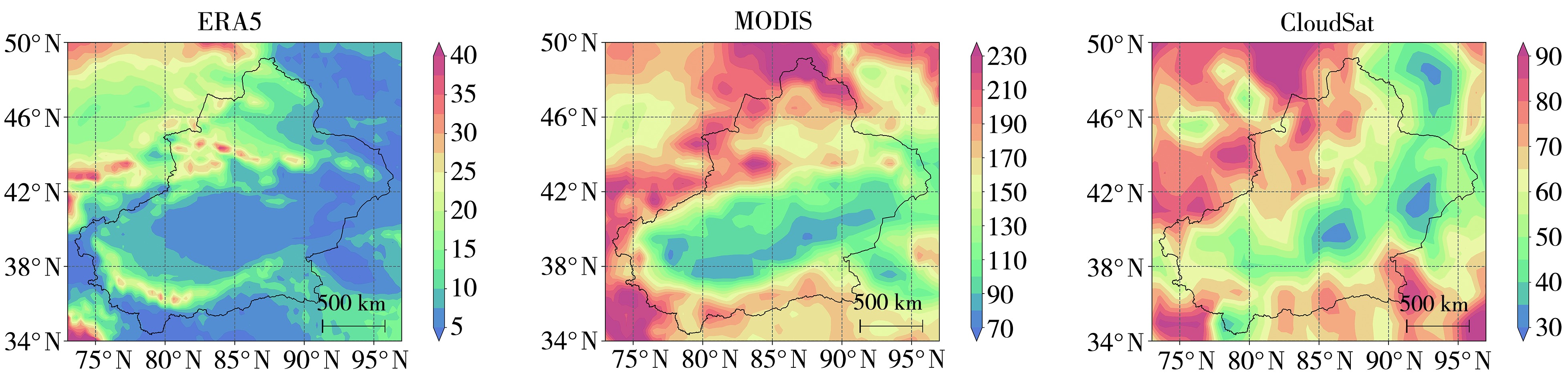
图6 新疆2007—2019年ERA5、MODIS及CloudSat反演的液水含量多年平均空间分布(单位:g·m-2)
Fig.6 Spatial distribution of the mean liquid water content retrieved from ERA5, MODIS and CloudSat over Xinjiang during 2007-2019 (Unit: g·m-2)
图6 新疆2007—2019年ERA5、MODIS及CloudSat反演的液水含量多年平均空间分布(单位:g·m-2)
Fig.6 Spatial distribution of the mean liquid water content retrieved from ERA5, MODIS and CloudSat over Xinjiang during 2007-2019 (Unit: g·m-2)
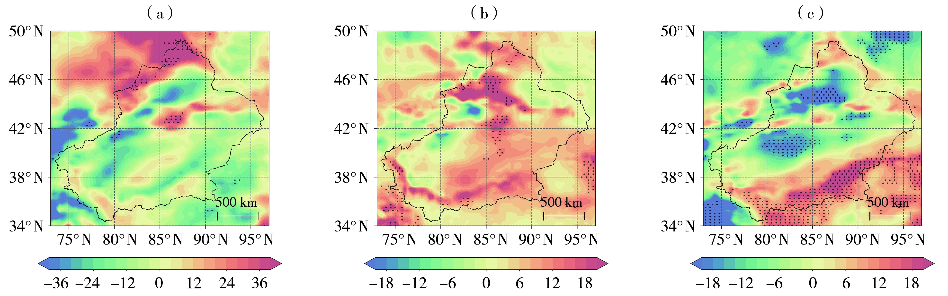
图7 新疆2007—2019年冰水含量(a)、液水含量(b)及云水含量(c)年变化趋势空间分布(单位:%·a-1)
Fig.7 Spatial distribution of the annual trend in ice water content (a), liquid water content (b), and cloud water content (c) over Xinjiang during 2007-2019 (Unit: %·a-1)
图7 新疆2007—2019年冰水含量(a)、液水含量(b)及云水含量(c)年变化趋势空间分布(单位:%·a-1)
Fig.7 Spatial distribution of the annual trend in ice water content (a), liquid water content (b), and cloud water content (c) over Xinjiang during 2007-2019 (Unit: %·a-1)
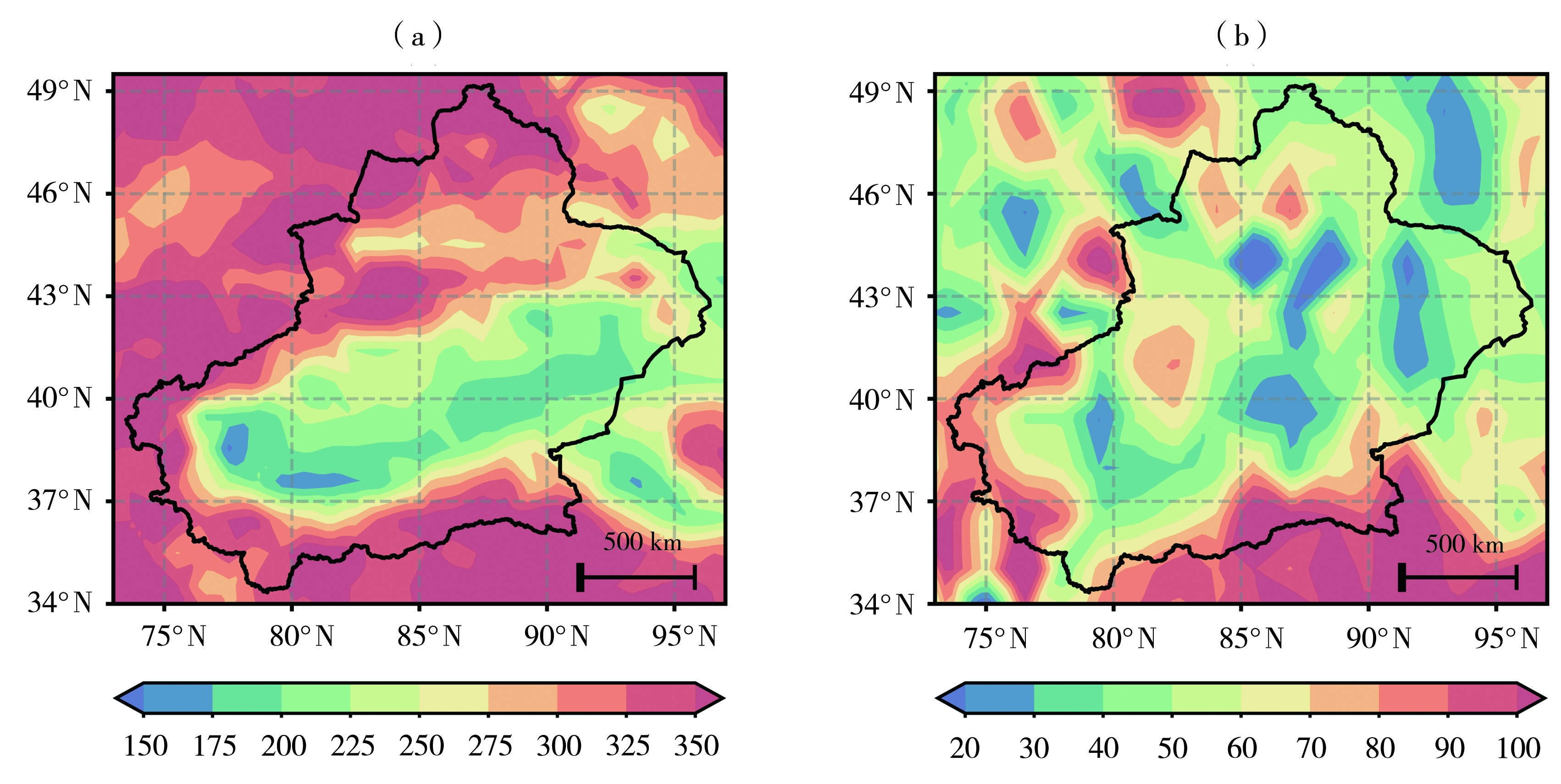
图8 新疆2007—2019年MODIS(a)及CloudSat(b)与ERA5云水含量差值空间分布(单位:g·m-2)
Fig.8 Spatial distribution of differences in cloud water content between MODIS and ERA5 (a) and between CloudSat and ERA5 (b) over Xinjiang during 2007-2019 (Unit: g·m-2)
图8 新疆2007—2019年MODIS(a)及CloudSat(b)与ERA5云水含量差值空间分布(单位:g·m-2)
Fig.8 Spatial distribution of differences in cloud water content between MODIS and ERA5 (a) and between CloudSat and ERA5 (b) over Xinjiang during 2007-2019 (Unit: g·m-2)
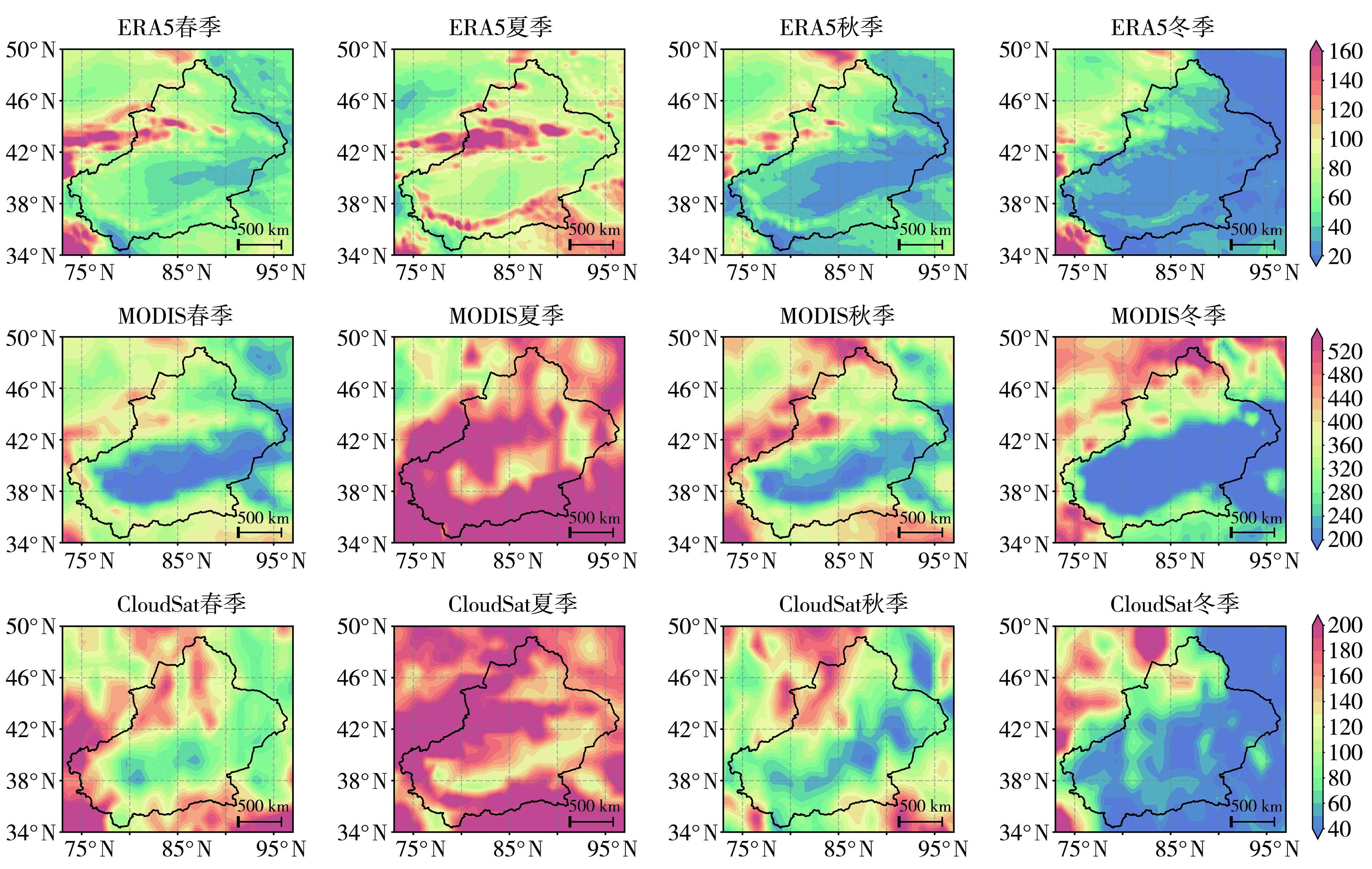
图9 新疆2007—2019年不同资料反演的云水含量季节平均空间分布(单位:g·m-2)
Fig.9 Spatial distribution of seasonal mean cloud water content retrieved from different datasets over Xinjiang during 2007-2019 (Unit: g·m-2)
图9 新疆2007—2019年不同资料反演的云水含量季节平均空间分布(单位:g·m-2)
Fig.9 Spatial distribution of seasonal mean cloud water content retrieved from different datasets over Xinjiang during 2007-2019 (Unit: g·m-2)
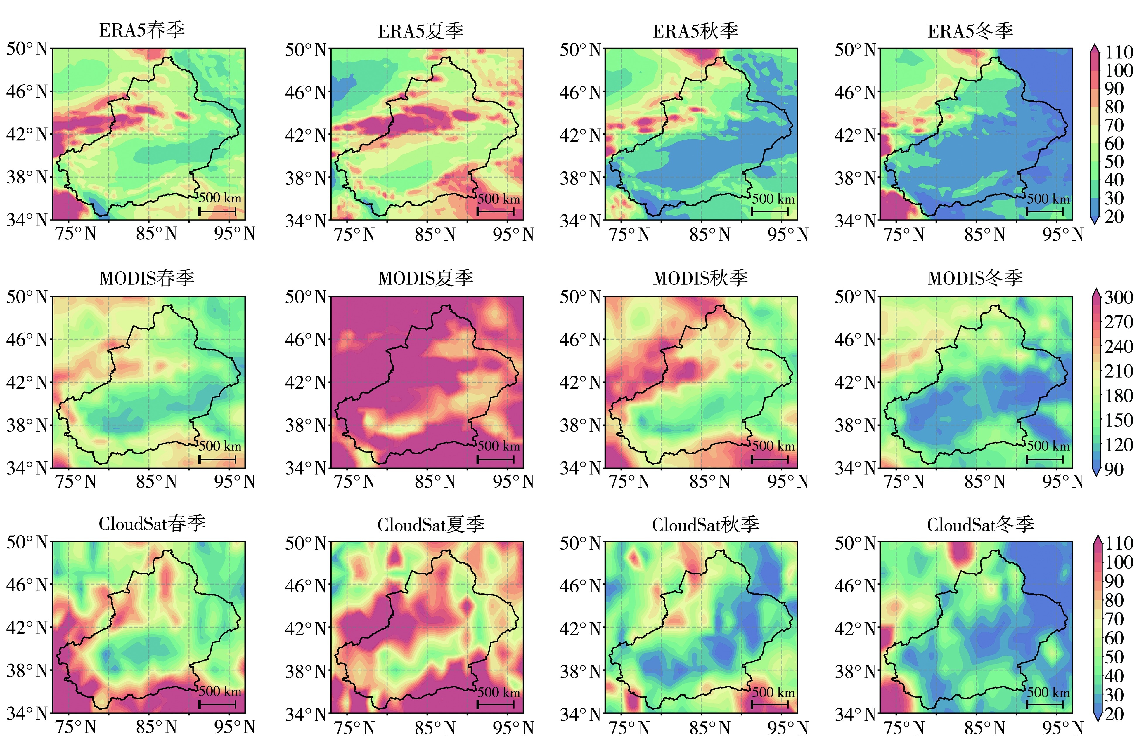
图10 新疆2007—2019年不同资料反演的冰水含量季节平均空间分布(单位:g·m-2)
Fig.10 Spatial distribution of seasonal mean ice water content retrieved from different datasets over Xinjiang during 2007-2019 (Unit: g·m-2)
图10 新疆2007—2019年不同资料反演的冰水含量季节平均空间分布(单位:g·m-2)
Fig.10 Spatial distribution of seasonal mean ice water content retrieved from different datasets over Xinjiang during 2007-2019 (Unit: g·m-2)
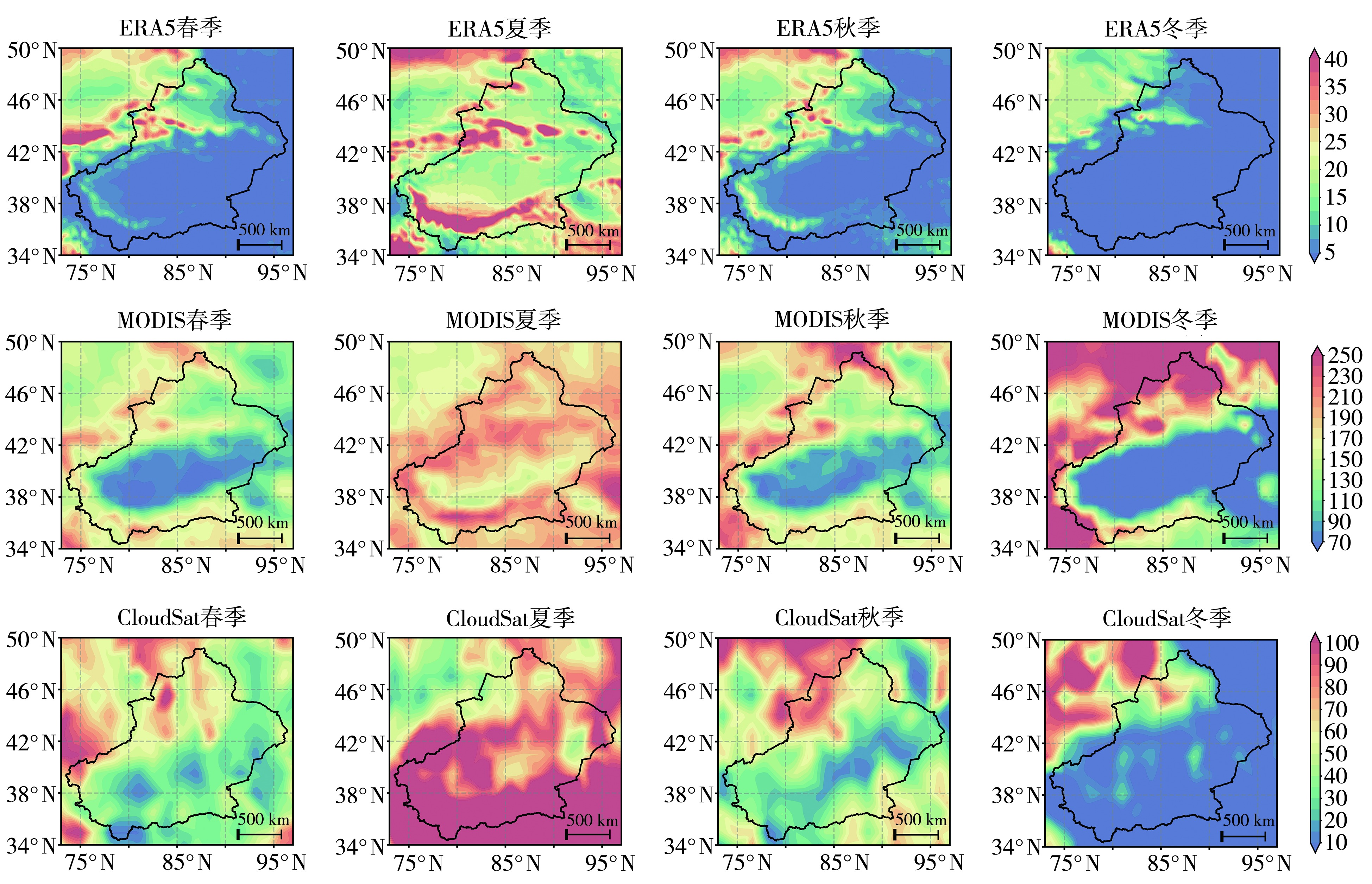
图11 新疆2007—2019年不同资料反演的液水含量季节平均空间分布(单位:g·m-2)
Fig.11 Spatial distribution of seasonal mean liquid water content retrieved from different datasets over Xinjiang during 2007-2019 (Unit: g·m-2)
图11 新疆2007—2019年不同资料反演的液水含量季节平均空间分布(单位:g·m-2)
Fig.11 Spatial distribution of seasonal mean liquid water content retrieved from different datasets over Xinjiang during 2007-2019 (Unit: g·m-2)
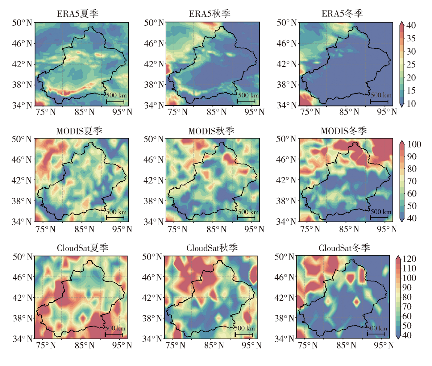
图12 新疆2007—2019年不同资料反演的云水含量标准差季节平均的空间分布(单位:g·m-2)
Fig.12 Spatial distribution of seasonal mean standard deviation of cloud water content retrieved from different datasets over Xinjiang during 2007-2019 (Unit: g·m-2)
图12 新疆2007—2019年不同资料反演的云水含量标准差季节平均的空间分布(单位:g·m-2)
Fig.12 Spatial distribution of seasonal mean standard deviation of cloud water content retrieved from different datasets over Xinjiang during 2007-2019 (Unit: g·m-2)
| [1] |
邓佩云, 常倬林, 何佳, 等, 2024. 六盘山地区大气水汽的时空差异与驱动因子分析[J]. 干旱气象, 42(3):376-384.
DOI |
| [2] | 方乐锌, 李昀英, 孙国荣, 等, 2016. 基于CloudSat-CALIPSO资料的全球不同类型云的水平和垂直分布特征[J]. 气候与环境研究, 21(5):547-556. |
| [3] |
高建秋, 郑彬, 游积平, 等, 2022. 2018年广东空中水物质评估及开发分析[J]. 干旱气象, 40(3):516-523.
DOI |
| [4] | 耿蓉, 王雨, 傅云飞, 等, 2018. 中国及其周边地区多种水凝物资料的气候态特征比较[J]. 气象学报, 76(1):134-147. |
| [5] | 郭娜, 陈伏龙, 王统霞, 等, 2025. 1979—2022年新疆地区空中水汽变化特征及未来多情景预估[J]. 干旱区研究, 42(10):1753-1 765. |
| [6] | 赫小红, 宋敏红, 周梓萱, 2020. 夏季青藏高原空中云水资源的时空特征分析[J]. 高原气象, 39(6):1339-1 347. |
| [7] | 李文韬, 李兴宇, 张礼林, 等, 2018. 青藏高原云水气候特征分析[J]. 气候与环境研究, 23(5):574-586. |
| [8] |
刘健, 2013. 利用卫星数据分析青藏高原云微物理特性[J]. 高原气象, 32(1):38-45.
DOI |
| [9] | 刘菊菊, 游庆龙, 周毓荃, 等, 2018. 基于ERA-Interim的中国云水量时空分布和变化趋势[J]. 高原气象, 37(6):1590-1 604. |
| [10] | 刘蕊, 2009. 新疆大气水汽含量、水汽通量及其净收支的计算和分析[D]. 乌鲁木齐: 新疆师范大学. |
| [11] |
庞萬隆, 袁子玥, 马秀枝, 等, 2025. 新疆伊犁河流域近30 a极端高温时空分布特征[J]. 干旱气象, 43(4):521-530.
DOI |
| [12] | 乔丹杨, 王瑾婷, 彭力, 等, 2025. 一次强冰雹天气环境场及卫星云参数特征分析[J]. 沙漠与绿洲气象, 19(2):84-91. |
| [13] | 史玉光, 孙照渤, 2008a. 新疆大气可降水量的气候特征及其变化[J]. 中国沙漠, 28(3):519-525. |
| [14] | 史玉光, 孙照渤, 2008b. 新疆水汽输送的气候特征及其变化[J]. 高原气象, 27(2):310-319. |
| [15] | 王凯, 孙美平, 巩宁刚, 2018. 西北地区大气水汽含量时空分布及其输送研究[J]. 干旱区地理, 41(2):290-297. |
| [16] | 王旭, 张嘉伟, 马禹, 等, 2016. 天山山脉强降水云宏微观物理属性的空间分布特征[J]. 干旱区地理, 39(6):1153-1 161. |
| [17] | 肖生春, 苏靖茸, 彭小梅, 等, 2024. 中国西北干旱内陆区季风-西风交互作用研究进展[J]. 高原气象, 43(6):1355-1 363. |
| [18] |
姚俊强, 2024. 新疆空中水资源和地表水资源变化特征研究[J]. 干旱区研究, 41(2):181-190.
DOI |
| [19] | 余杰, 蔡淼, 周毓荃, 等, 2024. 2000—2019年西北地区云水资源时空特征研究[J]. 气象学报, 82(4):476-489. |
| [20] | 张海宏, 石明明, 吴昊, 等, 2021. 基于ERA-Interim资料的青海省空中云水资源评估[J]. 干旱气象, 39(4):569-576. |
| [21] | 张敬书, 荆林海, 王思远, 2023. 近20年青藏高原云分布特征及云参数时空变化分析[J]. 高原气象, 42(5):1107-1 118. |
| [22] | 张沛, 姚展予, 贾烁, 等, 2020. 六盘山地区空中水资源特征及水凝物降水效率研究[J]. 大气科学, 44(2):421-434. |
| [23] | 张正国, 陈燕丽, 简悦, 等, 2024. 桂西岩溶区云水分布和移动特征[J]. 高原山地气象研究, 44(3):129-136. |
| [24] | 周茹, 李昀英, 陆春松, 2022. 基于CloudSat-CALIPSO资料的北极云宏观特征及形成机制研究[J]. 气候与环境研究, 27(5):630-642. |
| [25] | AUSTIN R T, HEYMSFIELD A J, STEPHENS G L, 2009. Retrieval of ice cloud microphysical parameters using the CloudSat millimeter-wave radar and temperature[J]. Journal of Geophysical Research: Atmospheres, 114(D8): 2008JD010049. DOI: 10.1029/2008jd010049. |
| [26] | DAI X G, YANG Y, WANG P, 2022. Asian monsoon projection with a new large-scale monsoon definition[J]. Theoretical and Applied Climatology, 147(3/4): 1 003-1 013. |
| [27] | ELIASSON S, BUEHLER S A, MILZ M, et al, 2011. Assessing observed and modelled spatial distributions of ice water path using satellite data[J]. Atmospheric Chemistry and Physics, 11(1): 375-391. |
| [28] | JING X, YANG J, LI T, et al, 2022. Pre-activation of ice nucleating particles in deposition nucleation mode: Evidence from measurement using a static vacuum water vapor diffusion chamber in Xinjiang, China[J]. Geophysical Research Letters, 49(15): e2022GL099468. DOI: 10.1029/2022GL099468. |
| [29] | KHANAL S, WANG Z E, FRENCH J R, 2020. Improving middle and high latitude cloud liquid water path measurements from MODIS[J]. Atmospheric Research,243:105033. DOI:10.1016/j.atmosres.2020.105033. |
| [30] | LI J F, WALISER D E, CHEN W T, et al, 2012. An observationally based evaluation of cloud ice water in CMIP3 and CMIP5 GCMs and contemporary reanalyses using contemporary satellite data[J]. Journal of Geophysical Research: Atmospheres, 117(D16): 2012JD017640. DOI:10.1029/2012jd017640. |
| [31] | TANG Y, WAN S M, CLIFT P D, et al, 2022. Northward shift of the Northern Hemisphere westerlies in the early to late Miocene and its links to Tibetan uplift[J]. Geophysical Research Letters, 49(18): e2022GL099311. DOI: 10.1029/2022GL099311. |
| [32] | WANG T, FETZER E J, WONG S, et al, 2016. Validation of MODIS cloud mask and multilayer flag using CloudSat-CALIPSO cloud profiles and a cross-reference of their cloud classifications[J]. Journal of Geophysical Research: Atmospheres, 121(19): 11 620-11 635. |
| [33] | WILCOX E M HARSHVARDHAN, PLATNICK S, 2009. Estimate of the impact of absorbing aerosol over cloud on the MODIS retrievals of cloud optical thickness and effective radius using two independent retrievals of liquid water path[J]. Journal of Geophysical Research: Atmospheres, 114(D5): 2008JD010589. DOI:10.1029/2008jd010589. |
| [34] | YANG P, WEI H L, BAUM B A, et al, 2003. The spectral signature of mixed-phase clouds composed of non-spherical ice crystals and spherical liquid droplets in the terrestrial window region[J]. Journal of Quantitative Spectroscopy and Radiative Transfer, 79: 1 171-1 188. |
| [35] |
YAO Z Y, AN L, ZHANG P, et al, 2023. Characteristics of cloud water resource and precipitation efficiency of hydrometeors over northwest China[J]. Journal of Meteorological Research, 37(3): 353-369.
DOI |
| [1] | 魏栋, 沙宏娥, 秦豪君, 吕巧谊, 刘丽伟, 傅朝. 西北中东部ECMWF-HR云量预报产品与FY-2G云量产品的对比[J]. 干旱气象, 2023, 41(3): 483-490. |
| [2] | 张海宏, 石明明, 吴昊, 祁栋林, 权晨. 基于ERA-Interim资料的青海省空中云水资源评估[J]. 干旱气象, 2021, 39(4): 569-576. |
| [3] | 达选芳, 李照荣, 王小勇, 刘抗, 邸燕君, 闫晓敏. 有云条件下太阳辐射短临预报订正技术研究[J]. 干旱气象, 2021, 39(06): 1006-1016. |
| [4] | 范思睿, 王维佳, 林丹. 基于ISCCP云资料的中国地区不同类型云的时空分布[J]. 干旱气象, 2020, 38(2): 213-225. |
| [5] | 彭冬梅, 陈鹏翔, 张旭. 基于卫星遥感的新疆地表太阳总辐射估算[J]. 干旱气象, 2019, 37(2): 322-330. |
| [6] | 马茜蓉1,游庆龙1,2,蔡淼3,周毓荃3,刘菊菊1. 基于CERES卫星资料分析中国近15 a云量变化[J]. 干旱气象, 2018, 36(6): 911-. |
| [7] | 王胜1,张强1,赵建华1,王兴2,徐燕3,白国强4. 典型干旱区陆面模式模拟检验[J]. 干旱气象, 2018, 36(6): 921-. |
| [8] | 黄海亮,靳双龙,王式功,陈录元,董春卿. 相似预报方法在山西省云量预报中的应用[J]. 干旱气象, 2018, 36(5): 845-851. |
| [9] | 张小军,马学谦,田建兵. 1961—2015年青海省总云量时空变化特征及影响因子[J]. 干旱气象, 2017, 35(4): 622-633. |
| [10] | 赵文婧,赵中军,汪结华,尚可政,王式功,柳志慧,孔德兵3,苏俊礼. 基于支持向量机的云量精细化预报研究[J]. 干旱气象, 2016, 34(3): 568-574. |
| [11] | 张义海1,杨晓玲1,陈海贝2,马中华1. 河西走廊东部云量时空变化特征[J]. 干旱气象, 2015, 33(6): 979-986. |
| [12] | 林丹. 西南地区不同类型云的云水含量时空分布和变化趋势[J]. 干旱气象, 2015, 33(5): 748-755. |
| [13] | 曹越前,张武,药静宇,王暐. 半干旱区云量变化特征及其与太阳辐射关系的研究[J]. 干旱气象, 2015, 33(4): 684-693. |
| [14] | 李慧晶,刘建西,刘东升,王维佳,林丹. 西南地区云量变化特征[J]. 干旱气象, 2014, 32(2): 194-200. |
| [15] | 丁晓东,黄建平,李积明,王天河,黄忠伟. 基于主动卫星遥感研究西北地区云层垂直结构特征及其对人工增雨的影响[J]. 干旱气象, 2012, 30(4): 529-538. |
| 阅读次数 | ||||||
|
全文 |
|
|||||
|
摘要 |
|
|||||
