干旱气象 ›› 2026, Vol. 44 ›› Issue (1): 95-102.DOI: 10.11755/j.issn.1006-7639-2026-01-0095

• 论文 • 上一篇    下一篇

2000—2020年黄河流域白银段植被生态质量时空变化特征

苗婷1(), 安俊宝1(), 武艳娟2, 苏荣醒3, 李菲4, 王金龙1, 甘泽良1, 郑琼1, 姜睿1, 刘晓蒙1   

  1. 1.白银市气象局,甘肃 白银 730900
    2.平凉市气象局,甘肃 平凉 744000
    3.兰州资源环境职业技术大学,甘肃 兰州 730100
    4.临夏回族自治州气象局,甘肃 临夏 731100
  • 收稿日期:2025-09-12 修回日期:2025-11-27 出版日期:2026-02-28 发布日期:2026-03-25
  • 通讯作者: 安俊宝(1989—),男,主要从事气象综合业务方面的研究。E-mail: anjb52895@163.com
  • 作者简介:苗婷(1988—),女,高级工程师,主要从事农业与生态气象方面的研究。E-mail: jyqxjmt@163.com
  • 基金资助:
    甘肃省气象局“飞天风云”人才专项(2425rczx-D-QNJCRC-13);甘肃省气象局科研项目(Ms2023-17)

Spatiotemporal characteristics of vegetation ecological quality in the Baiyin Section of the Yellow River Basin during 2000-2020

MIAO Ting1(), AN Junbao1(), WU Yanjuan2, SU Rongxing3, LI Fei4, WANG Jinlong1, GAN Zeliang1, ZHENG Qiong1, JIANG Rui1, LIU Xiaomeng1   

  1. 1. Baiyin Meteorological Bureau,Baiyin 730900,Gansu,China
    2. Pingliang Meteorological Bureau,Pingliang 744000,Gansu,China
    3. Lanzhou University of Resources and Environmental Technology,Lanzhou 730100,China
    4. Linxia Hui Autonomous Prefecture Meteorological Bureau,Linxia 731100,Gansu,China
  • Received:2025-09-12 Revised:2025-11-27 Online:2026-02-28 Published:2026-03-25

摘要:

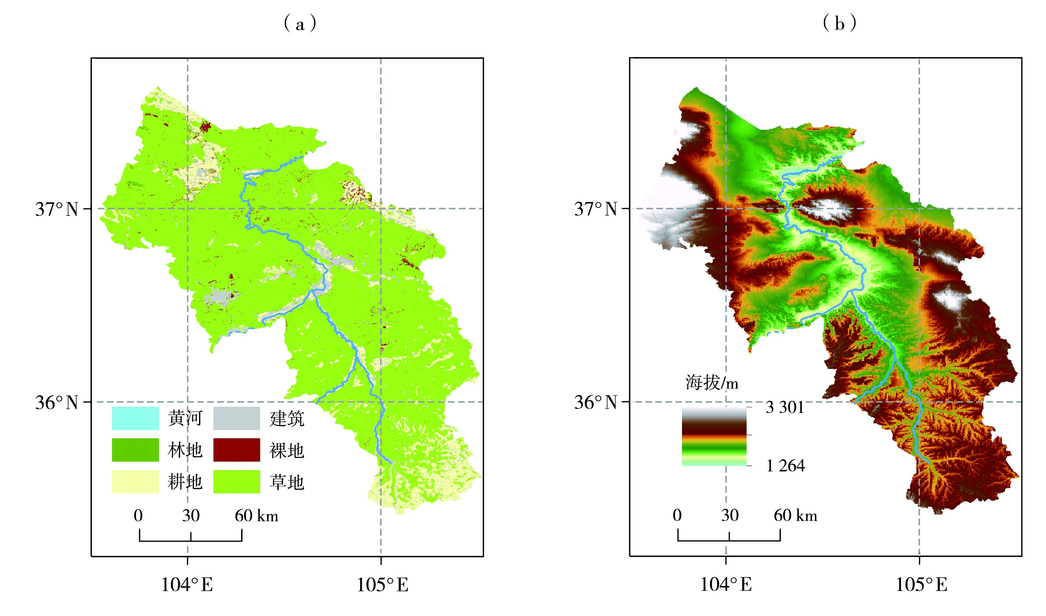
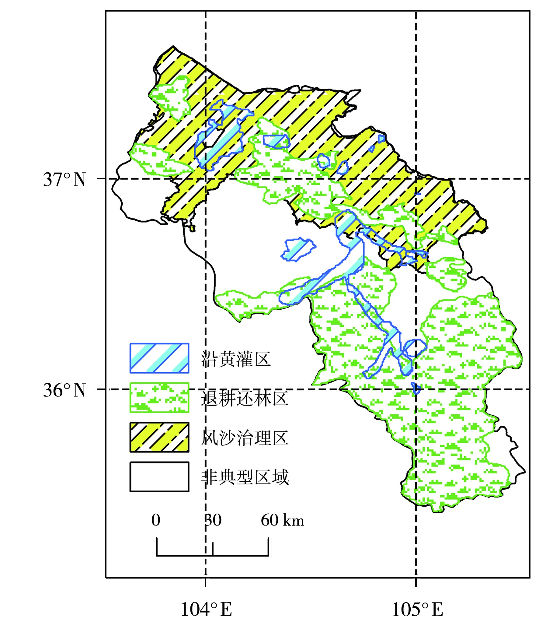
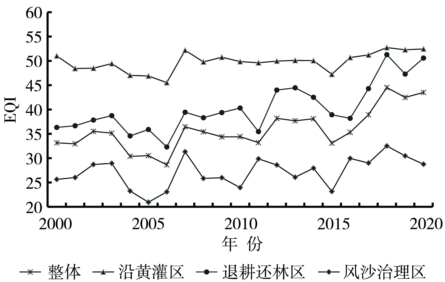
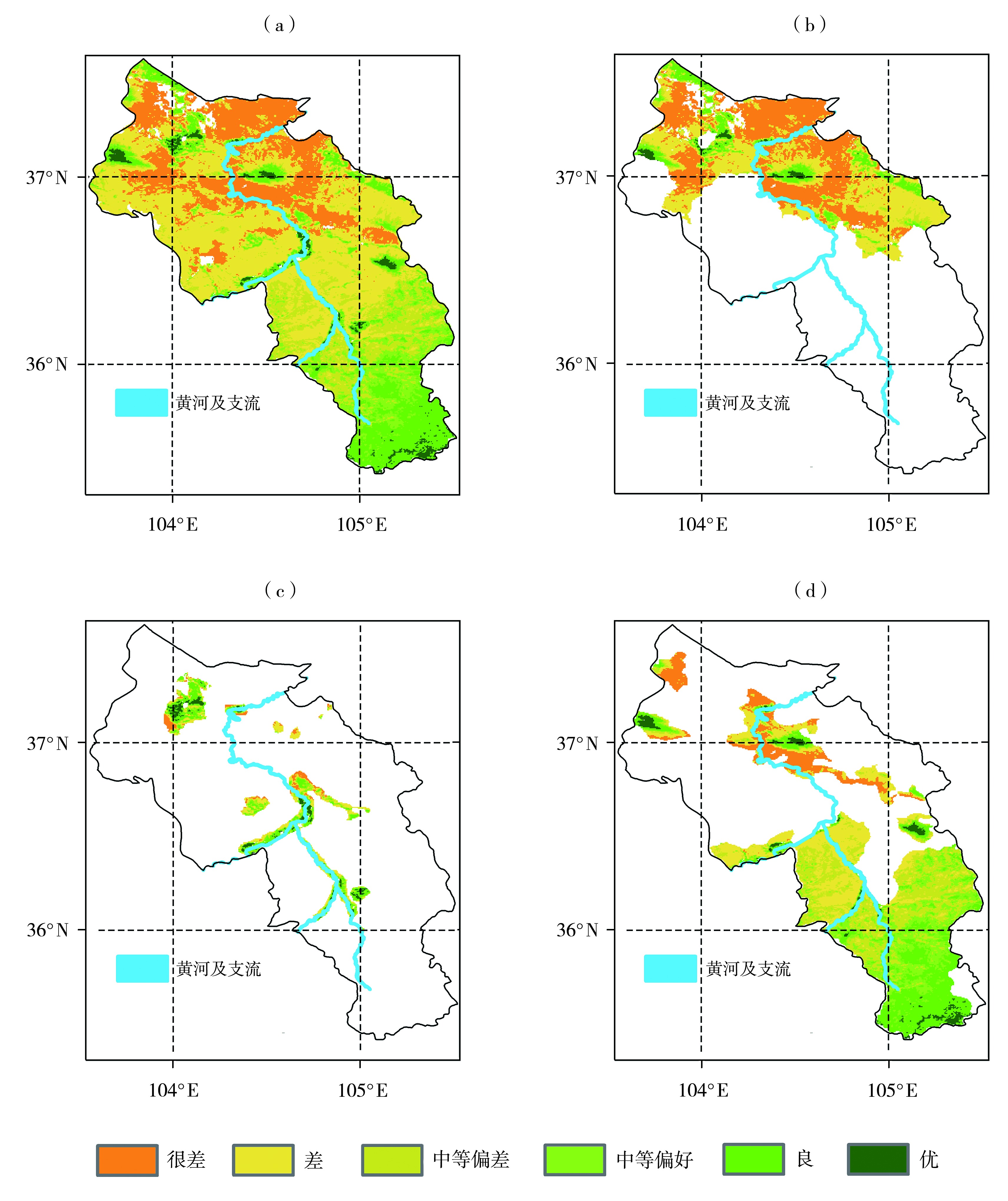
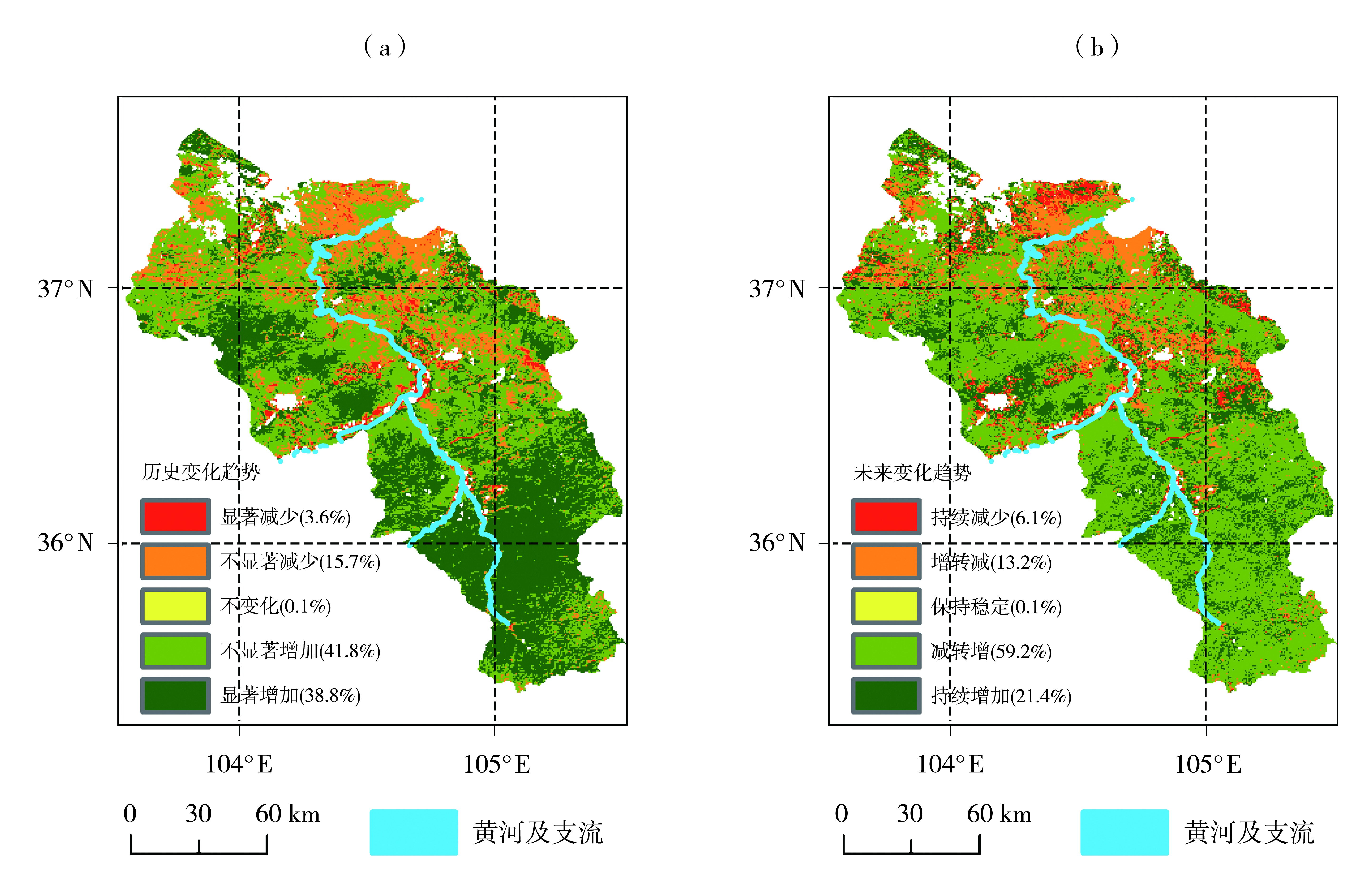
为评估黄河上游生态脆弱区植被生态质量及国家重点生态工程的实施成效,选取黄河流域白银段为研究区,划分风沙治理区、沿黄灌区和退耕还林区等典型生态功能区,基于2000—2020年多源遥感数据,构建植被生态质量指数(Ecological Quality Index,EQI),并采用趋势分析与空间统计方法,系统揭示EQI的时空演变特征及未来变化趋势。结果表明,近21 a,研究区EQI总体呈显著上升趋势,沿黄灌区EQI均值最高(49.8);退耕还林区增速最快(0.63 a-1),明显高于全域平均水平,生态工程对区域生态质量提升具有关键驱动作用。EQI空间上呈现“南高北低”的梯度格局与“生态孤岛”现象,高值区分布于黄河灌区和哈思山、条山农场等地,低值区集中于北部景泰—靖远干旱带及黄土丘陵区,空间分异受水分条件、地形背景与人类活动的综合影响。历史变化显示80.6%的区域生态质量得到改善,未来预测表明21.4%的区域可能持续恢复,但平川北部、靖远北部及景泰东南部存在生态逆转风险。研究表明,国家重点生态治理工程在黄河流域白银段的生态保护和治理工作取得显著成效。

关键词: 黄河流域白银段, 典型区域, 植被生态质量, 时空变化, 趋势分析

Abstract:

To assess the vegetation ecological quality in the ecologically fragile region of the upper Yellow River and evaluate the effectiveness of national key ecological restoration projects, this study selected the Baiyin Section of the Yellow River Basin as the research area and delineated typical ecological functional areas, including the sandstorm control area, the irrigation area along the Yellow River, and cropland-to-forest area. Based on multi-source remote sensing data from 2000 to 2020, the vegetation ecological quality index (EQI) was constructed, and trend analysis and spatial statistical methods were employed to systematically reveal the spatiotemporal evolution characteristics and future variation trends of EQI. The results show that, during the past 21 years, the EQI of the study area exhibited a significant upward trend; the irrigation area along the Yellow River had the highest mean EQI (49.8), while the grain for green area showed the fastest growth rate (0.63 a?1), indicating that ecological projects played a key driving role in improving regional ecological quality. The EQI presented a gradient pattern of “high in the south and low in the north” accompanied by an “ecological island” phenomenon spatially; high-value areas were mainly distributed in the Yellow River irrigation area and mountainous forest regions such as Hasi Mountain and Tiaoshan Farm, whereas low-value areas were concentrated in the Jingtai-Jingyuan arid belt and the loess hilly region in the north, reflecting the combined influence of water conditions, topography, and human activities. Historical analysis indicates that 80.6% of the region experienced ecological improvement, and future projections suggest that 21.4% of the area may continue to recover, while ecological reversal risks remain in northern Pingchuan, northern Jingyuan, and southeastern Jingtai. The study demonstrates that national key ecological governance projects have achieved remarkable effectiveness in ecological protection and restoration in the Baiyin Section of the Yellow River Basin.

Key words: Baiyin Section of the Yellow River Basin, typical regions, vegetation ecological quality, spatiotemporal changes, trend analysis

中图分类号: