干旱气象 ›› 2025, Vol. 43 ›› Issue (4): 607-615.DOI: 10.11755/j.issn.1006-7639-2025-04-0607
内蒙古东南部一次伴冻雨的极端暴雪天气特征
- 内蒙古自治区气象台,内蒙古 呼和浩特 010051
-
收稿日期:2025-01-16修回日期:2025-03-06出版日期:2025-08-31发布日期:2025-09-08 -
通讯作者:张桂莲(1966—),女,内蒙古呼和浩特人,正高级工程师,主要从事各种灾害性天气预报研究。E-mail: 2561750566@qq.com。
-
作者简介:赵睿峰(1994—),男,内蒙古包头人,工程师,主要从事灾害性天气预报研究。E-mail: rfzhao@163.com。 -
基金资助:内蒙古自治区自然科学基金项目(2023QN04008);内蒙古自治区自然科学基金项目(2024LHMS04022);内蒙古自治区自然科学基金项目(2025QN04043);内蒙古自治区自然科学基金项目(2025MS04044);中国气象局复盘总结专项项目(FPZJ2025-020);中国气象局复盘总结专项项目(FPZJ2025-021)
Characteristics of an extreme snowstorm with freezing rain in southeastern Inner Mongolia
ZHAO Ruifeng( ), ZHANG Guilian(), HUANG Xiaolu, HUO Zhili, JIANG Jing
- Inner Mongolia Autonomous Region Meteorological Observatory, Hohhot 010051, China
-
Received:2025-01-16Revised:2025-03-06Online:2025-08-31Published:2025-09-08
摘要:
伴冻雨的极端暴雪在内蒙古较少出现,研究此类天气对预报预警和灾害防御有重要意义。利用常规气象观测资料、欧洲中期天气预报中心ERA5再分析资料和内蒙古通辽多普勒天气雷达资料,针对2023年11月5—6日内蒙古东南部一次伴冻雨的极端暴雪天气过程,深入分析其发生的环境条件和成因。 结果表明:500 hPa高空冷涡、700 hPa暖式切变线、850 hPa偏东风急流以及北上的地面江淮气旋是此次过程的主要影响系统。冻雨发生时,垂直方向呈现“冷、暖、冷”的层结结构,925~875 hPa存在融化层,雷达基本反射率图中出现零度层亮带;过冷却水粒子和冰晶经零度层亮带进入融化层,之后降落到地面,这一过程符合融化型冻雨的特征。中层西南暖湿气流在低层偏东风形成的冷垫上爬升,产生强烈的动力锋生作用,为极端降雪提供了强劲的动力抬升条件,而强上升运动的存在和长时间维持,是导致极端暴雪天气发生的重要因素。暴雪区低层比湿最大达4~6 g·kg-1,且低层强水汽辐合维持时间长,为极端暴雪提供了充足的水汽供应。综合来看,此次内蒙古东南部伴随冻雨的极端暴雪天气,是高低空系统相互作用、动力锋生触发的垂直抬升以及持续水汽输送共同作用的结果。
中图分类号:
引用本文
赵睿峰, 张桂莲, 黄晓璐, 霍志丽, 江靖. 内蒙古东南部一次伴冻雨的极端暴雪天气特征[J]. 干旱气象, 2025, 43(4): 607-615.
ZHAO Ruifeng, ZHANG Guilian, HUANG Xiaolu, HUO Zhili, JIANG Jing. Characteristics of an extreme snowstorm with freezing rain in southeastern Inner Mongolia[J]. Journal of Arid Meteorology, 2025, 43(4): 607-615.
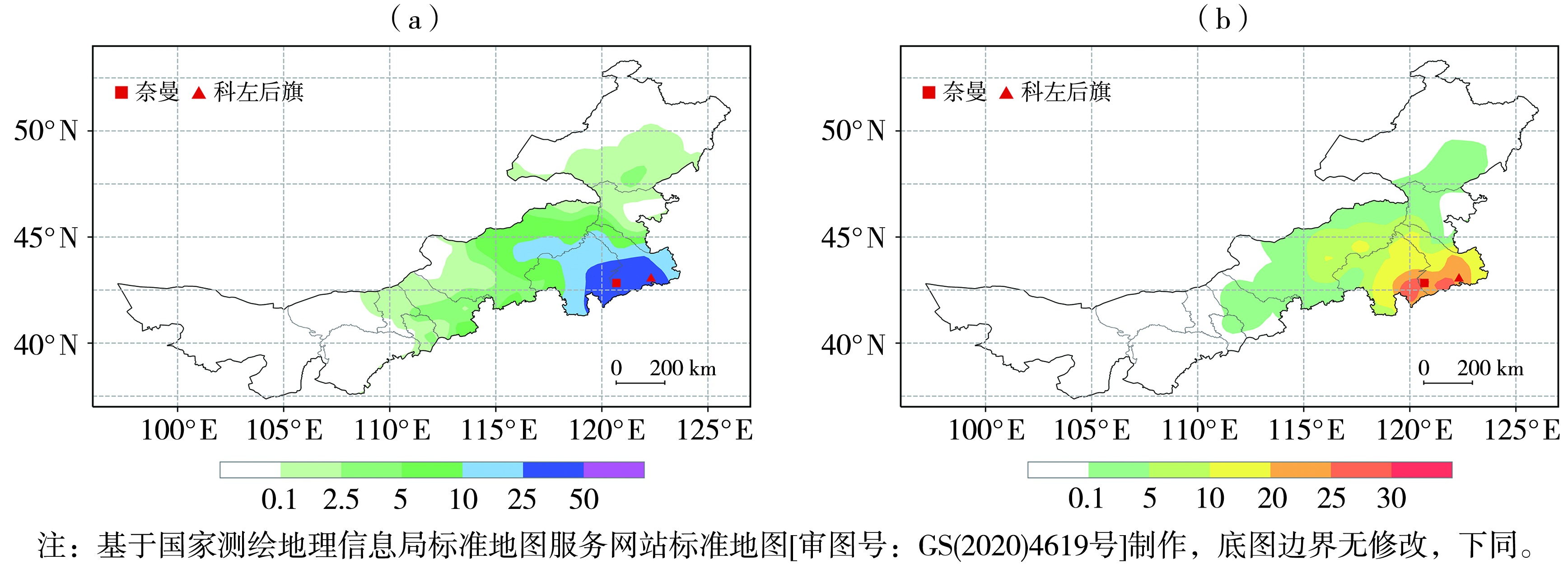
图1 2023年11月5日08:00—6日20:00内蒙古累计降水量(a,单位:mm)和新增积雪深度(b,单位:cm)
Fig.1 Accumulated precipitation (a, Unit: mm) and newly added snow depth (b, Unit: cm) in Inner Mongolia from 08:00 on 5 to 20:00 on 6 November 2023
图1 2023年11月5日08:00—6日20:00内蒙古累计降水量(a,单位:mm)和新增积雪深度(b,单位:cm)
Fig.1 Accumulated precipitation (a, Unit: mm) and newly added snow depth (b, Unit: cm) in Inner Mongolia from 08:00 on 5 to 20:00 on 6 November 2023

图2 2023年11月5日20:00(a、b)和6日08:00(c、d)500 hPa位势高度场(蓝色实线,单位:dagpm)和700 hPa风场(风矢,单位:m·s-1)(a、c)、海平面气压场(蓝色实线,单位:hPa)和850 hPa风场(风矢,单位:m·s-1)(b、d)
Fig.2 The 500 hPa geopotential height field (blue solid lines, Unit: dagpm) and 700 hPa wind field (wind vectors, Unit: m·s-1) (a, c), sea level pressure field (blue solid lines, Unit: hPa) and 850 hPa wind field (wind vectors, Unit: m·s-1) (b, d) at 20:00 on 5 (a, b) and 08:00 on 6 (c, d) November 2023

图3 2023年11月5日08:00—6日20:00科左后旗(a)和奈曼旗(b)逐小时降水量、2 m气温和相对湿度演变 (蓝色方框为出现冻雨的时段)
Fig.3 The evolution of hourly precipitation, 2 m air temperature and relative humidity of Kezuohouqi (a) and Naimanqi (b) from 08:00 on 5 to 20:00 on 6 November 2023 (The blue box shows the period of freezing rain)
图3 2023年11月5日08:00—6日20:00科左后旗(a)和奈曼旗(b)逐小时降水量、2 m气温和相对湿度演变 (蓝色方框为出现冻雨的时段)
Fig.3 The evolution of hourly precipitation, 2 m air temperature and relative humidity of Kezuohouqi (a) and Naimanqi (b) from 08:00 on 5 to 20:00 on 6 November 2023 (The blue box shows the period of freezing rain)
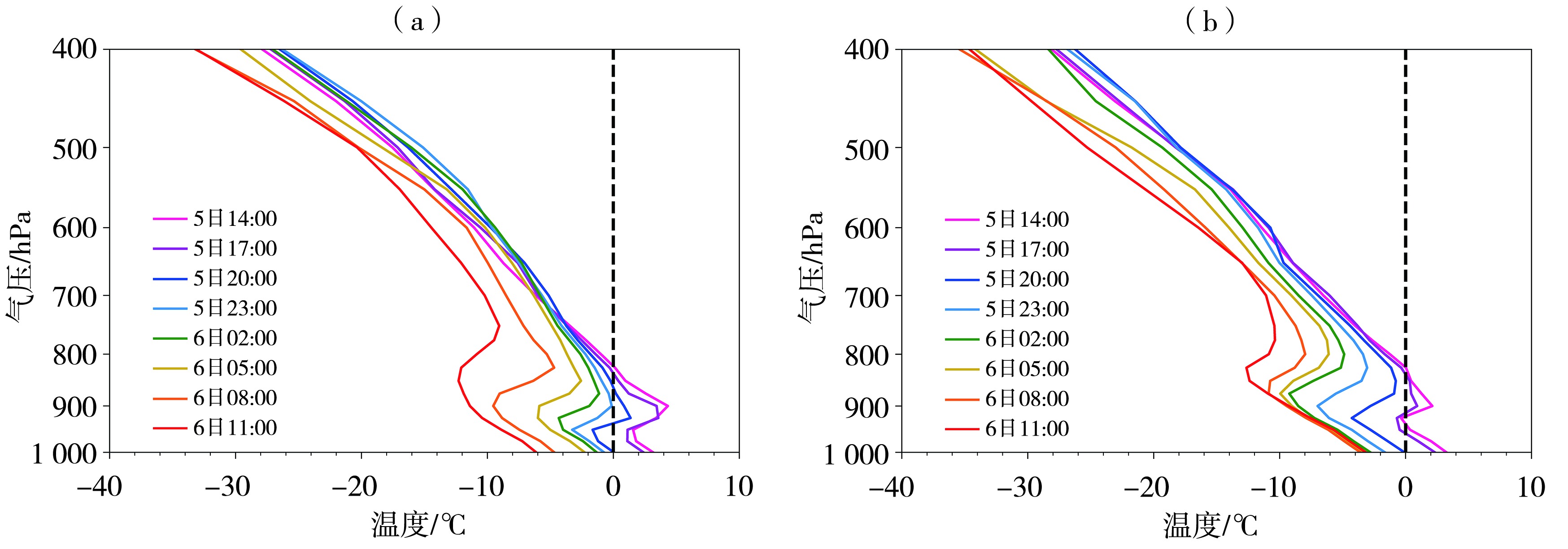
图4 2023年11月5日14:00—6日11:00科左后旗(a)和奈曼旗(b)逐3 h温度廓线 (黑色虚线为0 ℃等温线)
Fig.4 The 3-hour temperatures profiles of Kezuohouqi (a) and Naimanqi (b) from 14:00 on 5 to 11:00 on 6 November 2023 (Black dotted line is 0 ℃ isotherm)
图4 2023年11月5日14:00—6日11:00科左后旗(a)和奈曼旗(b)逐3 h温度廓线 (黑色虚线为0 ℃等温线)
Fig.4 The 3-hour temperatures profiles of Kezuohouqi (a) and Naimanqi (b) from 14:00 on 5 to 11:00 on 6 November 2023 (Black dotted line is 0 ℃ isotherm)
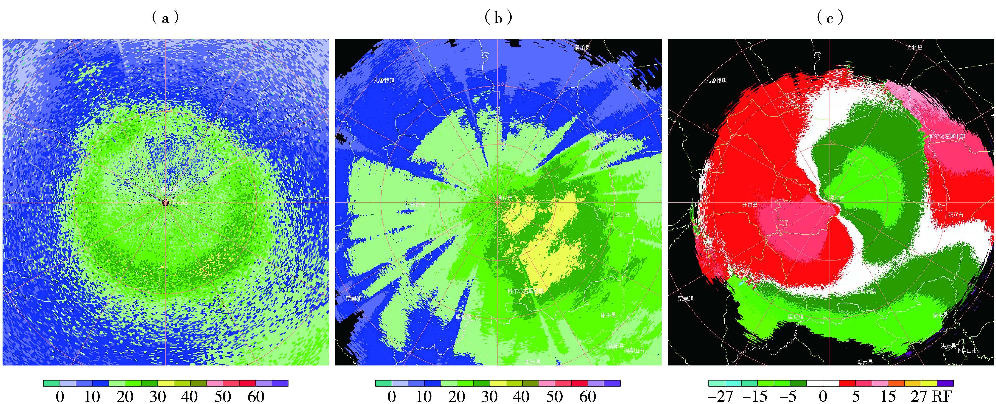
图5 2023年11月5日20:46(a)、6日00:05(b、c)通辽市多普勒雷达6.0°仰角基本反射率因子(a,单位:dBZ)、组合反射率(b,单位:dBZ)和2.4°仰角基本径向速度(c,单位:m·s-1)
Fig.5 The basic reflectivity factor on the elevation of 6.0° (a, Unit: dBZ), the composite reflectivity (b, Unit: dBZ) and radial velocity on the elevation of 2.4° (c, Unit: m·s-1) of Tongliao Doppler radar at 20:46 on 5 (a) and 00:05 on 6 (b, c) November 2023

图6 2023年11月5日08:00—6日20:00奈曼旗特大暴雪中心水汽通量散度(黑线,单位:10-6 g·cm-2·hPa-1·s-1)和水汽通量(填色,单位:g·cm-1·hPa-1·s-1)时间-高度剖面(a)、11月5日20:00大气可降水量(蓝线,单位:mm)和850 hPa比湿(填色,单位:g·kg-1)(b)
Fig.6 The height-time section of vapor flux divergence (black lines, Unit: 10-6 g·cm-2·hPa-1·s-1) and vapor flux (the color shaded, Unit: g·cm-1·hPa-1·s-1) over the severe snowstorm center from 08:00 on 5 to 20:00 on 6 November 2023 (a), the atmospheric precipitable amount (blue lines, Unit: mm) and 850 hPa specific humidity (the color shaded, Unit: g·kg-1) at 20:00 on 5 November 2023 (b)

图7 2023年11月5日08:00—6日20:00奈曼旗特大暴雪中心散度(黑线,单位:10-6 s-1)和垂直速度(填色,单位:10-1 Pa·s-1)的时间-高度剖面(a),6日02:00假相当位温(填色,单位:K)和风场(风矢,单位:m·s-1)沿42.8°N的经度-高度剖面(b) (红色方框为锋区)
Fig.7 The height-time section of divergence (black lines, Unit: 10-6 s-1) and vertical velocity (the color shaded, Unit: 10-1 Pa·s-1) over the severe snowstorm center from 08:00 on 5 to 20:00 on 6 November 2023 (a), the longitude-height section of pseudo-equivalent potential temperature (the color shaded, Unit: K) and the wind field (wind vectors, Unit: m·s-1) along 42.8°N at 02:00 on 6 November 2023 (b) (The red box shows the frontal area)
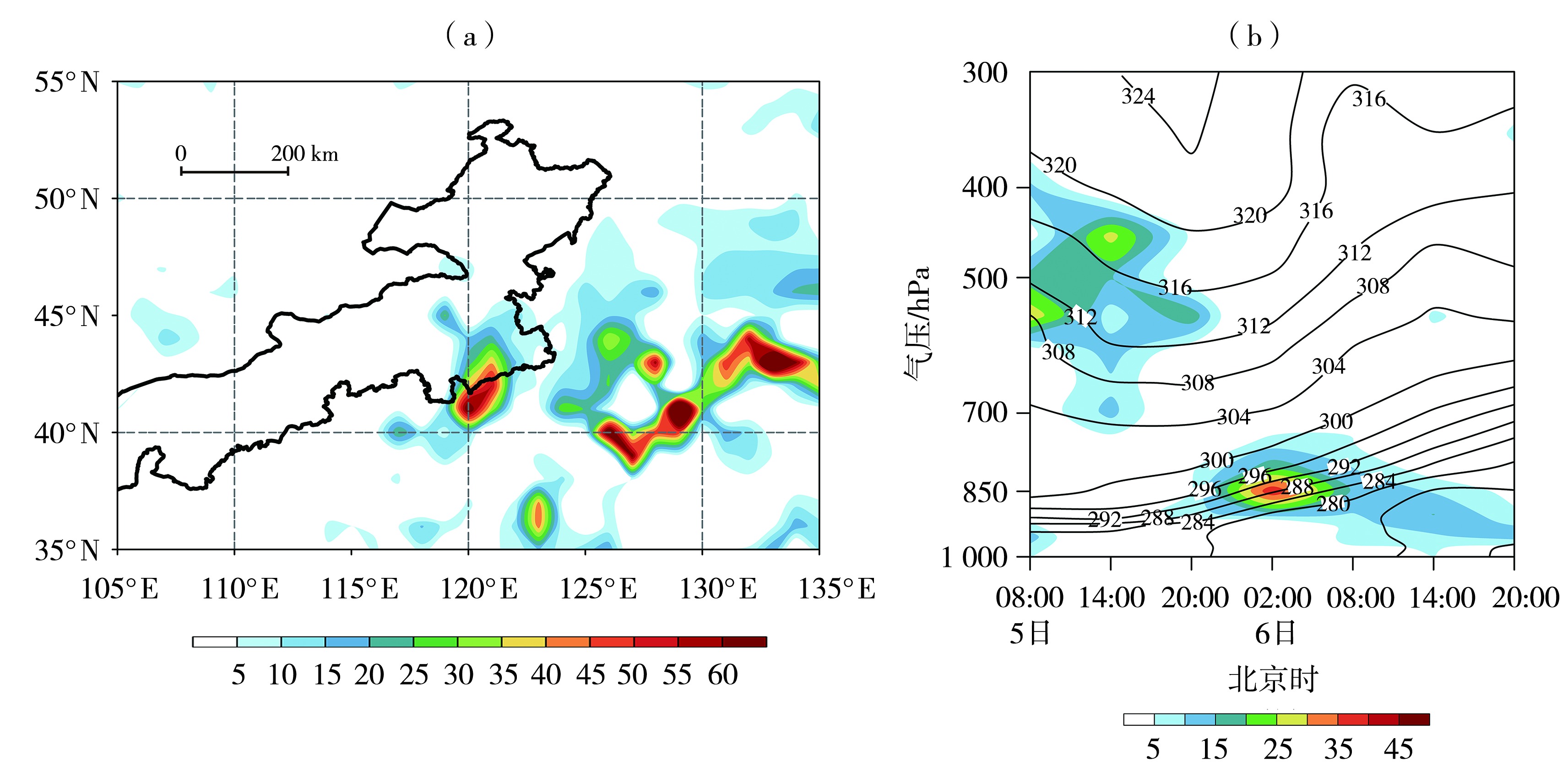
图8 2023年11月6日02:00 850 hPa锋生函数(填色,单位:10-10 K·m-1·s-1)分布(a),5日08:00—6日20:00奈曼旗特大暴雪中心锋生函数(填色,单位:10-10 K·m-1·s-1)和假相当位温(黑线,单位:K)时间-高度剖面(b)
Fig.8 Distribution of frontogenesis function (the color shaded, Unit: 10-10 K·m-1·s-1) at 850 hPa at 02:00 on 6 November 2023 (a), the height-time section of the frontogenesis function (the color shaded, Unit: 10-10 K·m-1·s-1) and pseudo-equivalent potential temperature (black solid lines, Unit: K) over the severe snowstorm center from 08:00 on 5 to 20:00 on 6 November 2023 (b)

图9 2021年11月7日(a)、2023年11月5日(b)不同时刻科左后旗站温度廓线 (黑色虚线为0 ℃等温线)
Fig.9 The temperature profiles at different time at Kezuohouqi Station on November 7, 2021 (a) and on November 5, 2023(b) (The black dotted line is 0 ℃ isotherm)
图9 2021年11月7日(a)、2023年11月5日(b)不同时刻科左后旗站温度廓线 (黑色虚线为0 ℃等温线)
Fig.9 The temperature profiles at different time at Kezuohouqi Station on November 7, 2021 (a) and on November 5, 2023(b) (The black dotted line is 0 ℃ isotherm)
| [1] | 安晶晶, 王东勇, 李慧敏, 等, 2024. 2024年2月我国两次大范围冻雨过程对比分析[J]. 暴雨灾害, 43(4):419-430. |
| [2] | 丁一汇, 王遵娅, 宋亚芳, 等, 2008. 中国南方2008年1月罕见低温雨雪冰冻灾害发生的原因及其与气候变暖的关系[J]. 气象学报, 66(5):808-825. |
| [3] | 冯丽莎, 宋攀, 郑飞, 等, 2020. 2016年初冬河南区域暴雪过程诊断分析[J]. 大气科学, 44(1):13-26. |
| [4] | 顾佳佳, 武威, 2015. 2014年2月4—7日河南暴雪过程的环流特征及其持续原因[J]. 暴雨灾害, 34(2):117-125. |
| [5] |
郭英香, 冯晓莉, 刘畅, 等, 2023. 1961—2021年青藏高原前后冬强降雪特征分析[J]. 干旱气象, 41(5):723-733.
DOI |
| [6] |
胡顺起, 曹张驰, 陈滔, 2017. 山东省南部一次极端特大暴雪过程诊断分析[J]. 高原气象, 36(4):984-992.
DOI |
| [7] | 黄小玉, 黎祖贤, 李超, 等, 2008. 2008年湖南极端冰冻特大灾害天气成因分析[J]. 气象, 34(11):47-53. |
| [8] | 黄晓璐, 林弘杰, 李一平, 等, 2021. 2020年初内蒙古一次暴雪天气过程的成因分析[J]. 沙漠与绿洲气象, 15(6):18-25. |
| [9] | 霍也, 李倩, 尚博, 等, 2023. 2020年11月吉林省罕见冻雨天气成因分析[J]. 气象与环境学报, 39(4):25-30. |
| [10] | 靳冰凌, 孙仲毅, 王辛方, 等, 2010. 2009年11月10-12日河南北部暴雪天气诊断分析[J]. 气象与环境科学, 33(2):63-67. |
| [11] | 马素艳, 高晶, 李一平, 等, 2022. 2020年内蒙古东南部一次特大暴雪伴冻雨灾害天气特征分析[J]. 气象科技, 50(3):380-389. |
| [12] | 马素艳, 张超, 史金丽, 2017. 回流与倒槽作用引发的内蒙古自治区两次暴雪天气过程分析[J]. 气象与环境学报, 33(1):19-25. |
| [13] | 孟雪峰, 孙永刚, 霍志丽, 等, 2022. 内蒙古一次极端暴雪事件中冻雨成因分析[J]. 沙漠与绿洲气象, 16(4):22-30. |
| [14] | 漆梁波, 2012. 我国冬季冻雨和冰粒天气的形成机制及预报着眼点[J]. 气象, 38(7):769-778. |
| [15] | 钤伟妙, 罗亚丽, 曹越, 等, 2022. 基于多种探测资料对华北中部一次回流暴雪过程的分析[J]. 气象学报, 80(5):732-747. |
| [16] |
任曼琳, 李忠燕, 王博卿, 等, 2023. 2021/2022年冬季贵州凝冻天气阶段性特征及成因[J]. 干旱气象, 41(5):744-752.
DOI |
| [17] | 王瀛, 陈宇, 李姝婷, 等, 2015. 辽宁地区一次罕见冻雨天气分析[J]. 气象与环境学报, 31(4):20-25. |
| [18] | 徐娟娟, 郝丽, 刘嘉慧敏, 等, 2020. 2018年1月陕西区域性暴雪过程诊断[J]. 干旱气象, 38(1):117-125. |
| [19] | 许婷婷, 张云惠, 于碧馨, 等, 2017. 2015年12月乌鲁木齐极端暴雪成因分析[J]. 沙漠与绿洲气象, 11(5):23-29. |
| [20] | 阎访, 孙婧怡, 范俊红, 等, 2021. 石家庄暴雪的时空演变特征[J]. 干旱气象, 39(6):939-947. |
| [21] | 杨晓君, 张楠, 陈宏, 等, 2019. 一次回流型降雪过程的成因和相态判据分析[J]. 气象科技, 47(1):98-105. |
| [22] | 尤凤春, 付桂琴, 刘卓, 等, 2015. 北京地区冻雨时空分布及探空温湿特征分析[J]. 气象, 41(12):1488-1 493. |
| [23] | 于波, 杜佳, 张琳娜, 2016. 1960—2013年北京地区冻雨天气过程特征分析[J]. 气象与环境学报, 32(4):113-118. |
| [24] | 张芳华, 陈涛, 杨舒楠, 等, 2014. 一次冬季暴雨过程中的锋生和条件对称不稳定分析[J]. 气象, 40(9): 1 048-1 057. |
| [25] |
张桂莲, 霍志丽, 王学强, 2023. 冷垫背景下冻雨和极端大暴雪成因机制分析[J]. 高原气象, 42(3):725-733.
DOI |
| [26] |
张桂莲, 刘澜波, 孟雪峰, 等, 2022. 冷垫背景下回流暴雪成因与雷达回波特征分析[J]. 干旱气象, 40(3):500-506.
DOI |
| [27] |
张入财, 王君, 陈超辉, 等, 2023. 印度双低涡对青藏高原西部一次典型暴雪过程的影响[J]. 干旱气象, 41(3):463-473.
DOI |
| [28] | 张智, 韩永翔, 王瑾, 等, 2016. 高原山地环境下冻雨微物理特征及成因分析[J]. 气象科学, 36(3):389-395. |
| [29] |
赵桂香, 2014. 诊断分析技术在山西强降雪预报中的应用[J]. 高原气象, 33(3):838-847.
DOI |
| [30] | 周雪松, 谈哲敏, 2008. 华北回流暴雪发展机理个例研究[J]. 气象, 34(1):18-26. |
| [31] | CHEN G J, WANG C C, WANG A H, 2007. A case study of subtropical frontogenesis during a blocking event[J]. Monthly Weather Review, 135(7):2588-2 609. |
| [32] | HOBBS P V, RANGNO A L, 1985. Ice particle concentrations in clouds[J]. Journal of the Atmospheric Sciences, 42(23): 2 523-2 549. |
| [33] | ZHUANG H Y, DEGAETANO A T, LEHNER F, 2024. Internal climate variability obscures future freezing rain changes despite global warming trend[J]. Geophysical Research Letters, 51(23): e2024GL111741. DOI:10.1029/2024GL111741. |
| [1] | 杨旗, 张海鹏, 吴建蓉, 李昊, 曾华荣, 陆正奇. 对冬季云贵—华南准静止锋上一次多相态降水过程的模拟研究[J]. 干旱气象, 2024, 42(1): 75-83. |
| [2] | 张桂莲, 刘澜波, 孟雪峰, 张璐, 李林惠. 冷垫背景下回流暴雪成因与雷达回波特征分析[J]. 干旱气象, 2022, 40(3): 500-506. |
| [3] | 李美琪, 郭蕊, 贾小卫, 吴丹, 时青格, 刘浩. 冀中南一次持续性大雾过程成因及维持机制[J]. 干旱气象, 2020, 38(4): 591-600. |
| [4] | 尹承美, 焦洋, 何建军, 冯俊杰. 济南地区逆温层特征及其对颗粒物质量浓度的影响[J]. 干旱气象, 2019, 37(4): 622-638. |
| [5] | 吴进,李琛,孙兆彬,王华,马小会. 北京地区两次重污染过程中PM2.5浓度爆发性增长及维持的气象条件[J]. 干旱气象, 2017, 35(5): 830-838. |
| [6] | 陈军,李小兰,喻义军,方标,滕林,胡萍. 贵州铜仁一次大范围高架雷暴降雹天气过程分析[J]. 干旱气象, 2017, 35(4): 649-656. |
| [7] | 卢秉红,杨青,高松影,韩江文,阎琦,梁寒,苏航,刘硕. 两次不同类型暴雪的雷达回波特征分析[J]. 干旱气象, 2016, 34(5): 836-840. |
| [8] | 郭萍萍1,杨建才2,殷雪莲1,郑学金1. 甘肃省春季一次连续浮尘天气过程分析[J]. 干旱气象, 2015, 33(2): 303-309. |
| [9] | 马 艳,郭丽娜,黄 容. 青岛一次沙尘污染事件的气象条件特征[J]. 干旱气象, 2014, 32(5): 773-780. |
| [10] | 姚蓉, 黎祖贤, 许霖, 唐杰, 陈静静. 湖南冻雨预报关键技术指标及应用[J]. 干旱气象, 2014, 32(3): 366-372. |
| [11] | 郑庆锋,史军. 上海地区大气贴地逆温的气候特征[J]. J4, 2011, 29(2): 195-200. |
| [12] | 丁小剑, 杨 军, 唐明晖, 何正阳, 李象玉. 湖南2次典型的冰冻灾害天气特征及成因分析[J]. J4, 2010, 28(1): 76-80. |
| [13] | 侯瑞钦, 李江波, 赵玉广. 河北平原一次持续大雾天气分析[J]. J4, 2009, 27(3): 263-270. |
| 阅读次数 | ||||||
|
全文 |
|
|||||
|
摘要 |
|
|||||
