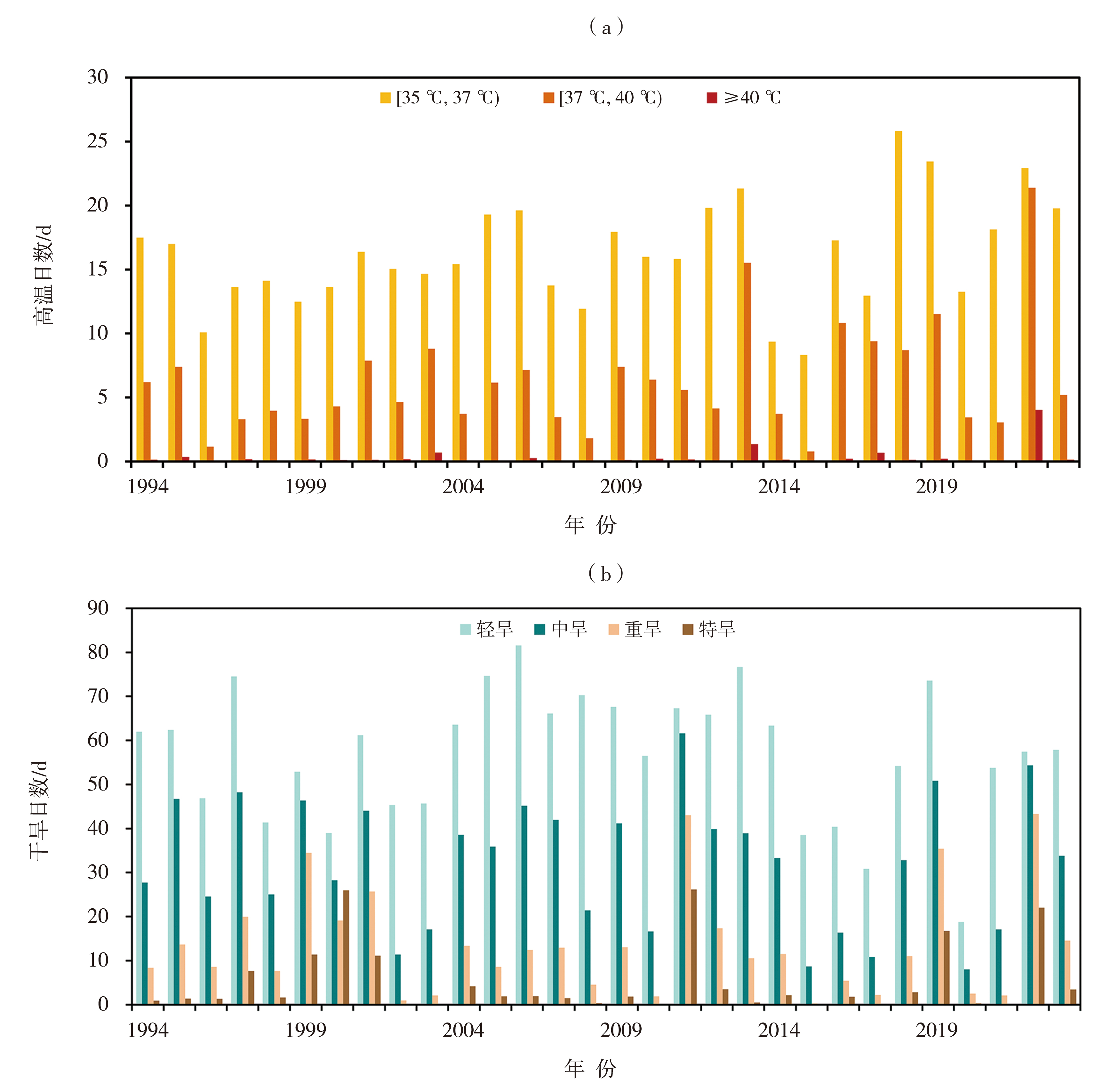
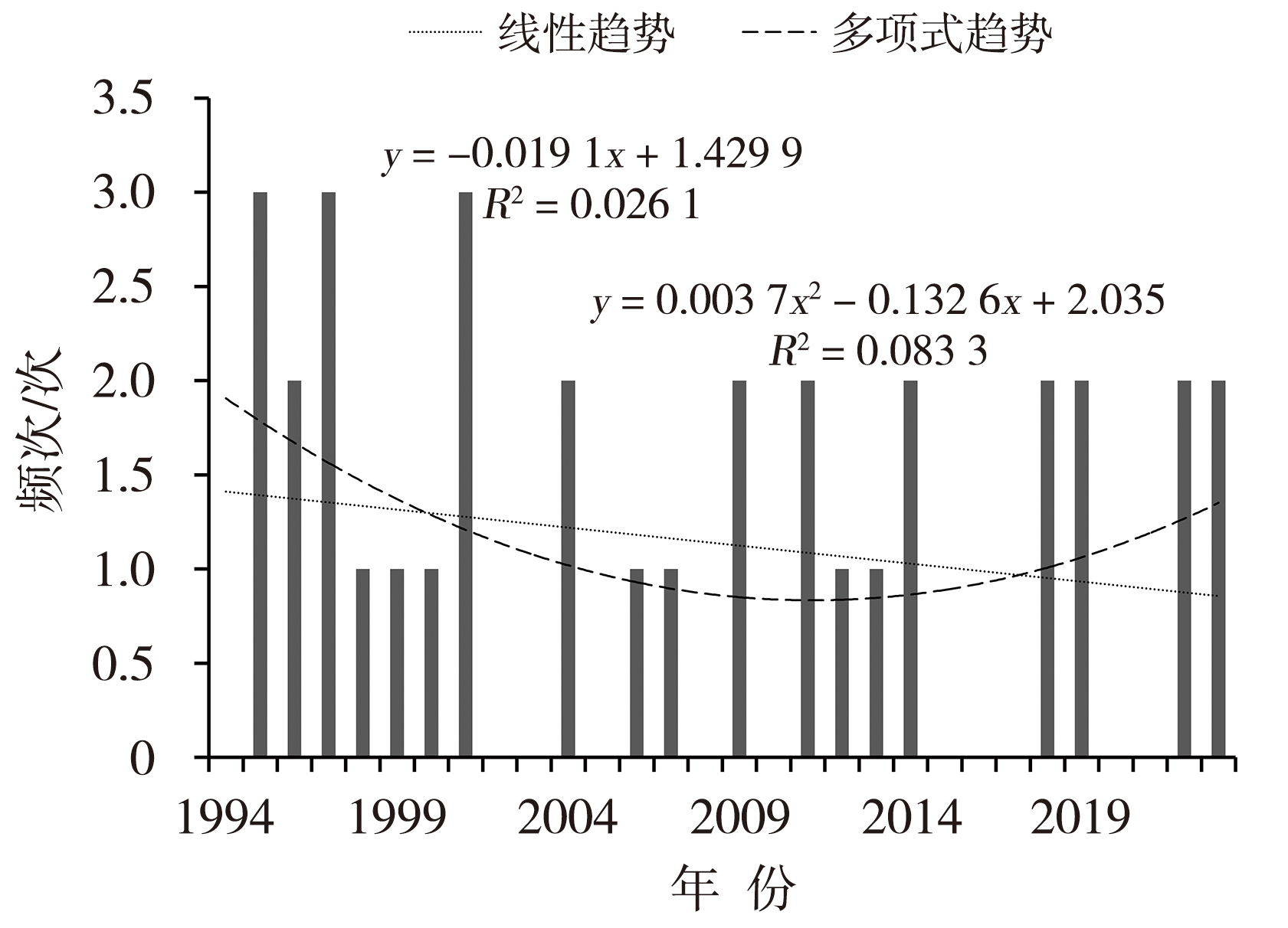
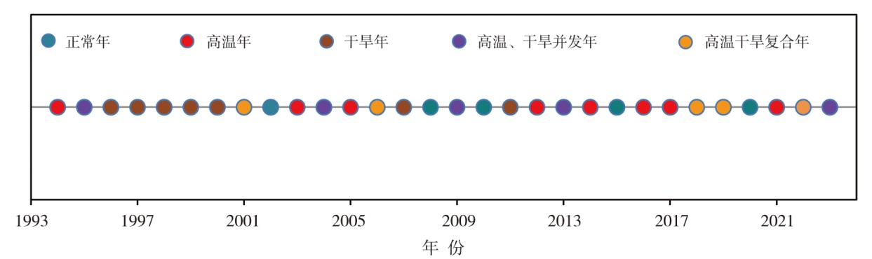
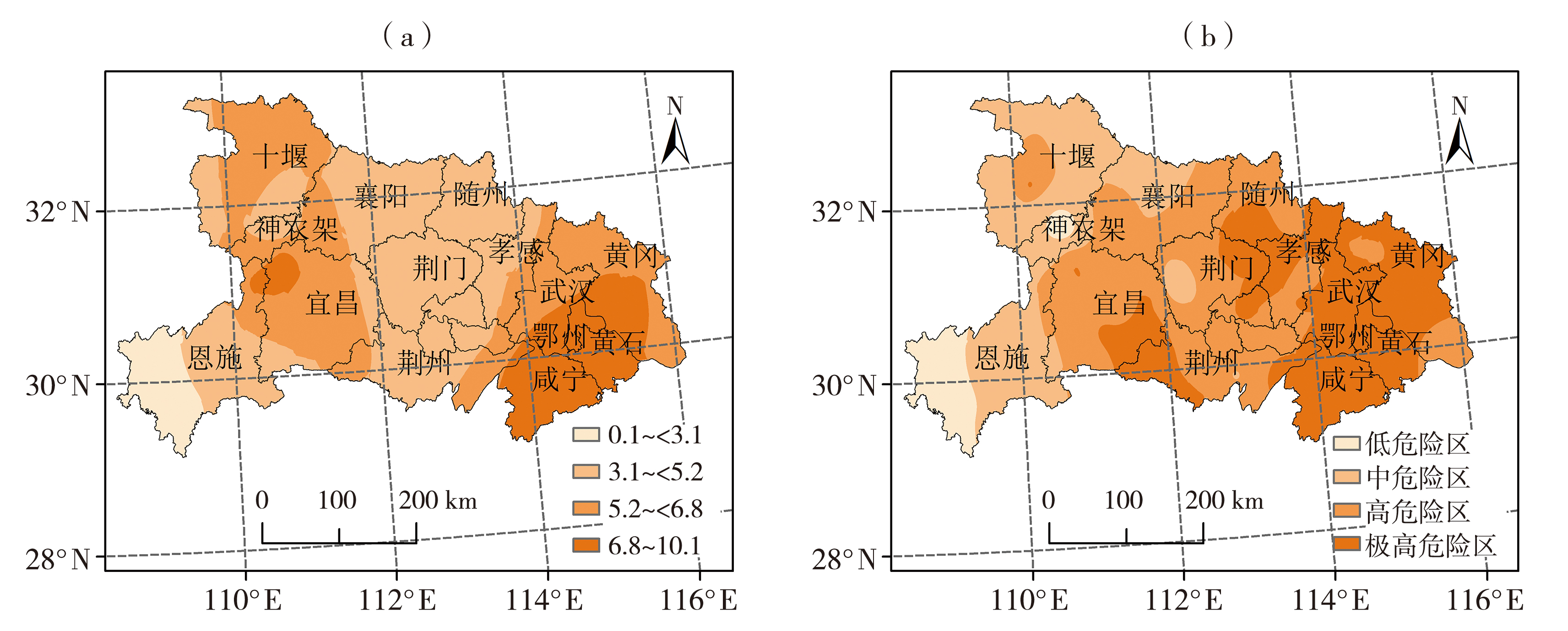
| [1] |
范进进, 秦鹏程, 史瑞琴, 等, 2022. 气候变化背景下湖北省高温干旱复合灾害变化特征[J]. 干旱气象, 40(5): 780-790.
DOI
|
| [2] |
高歌, 黄大鹏, 赵珊珊, 2019. 基于信息扩散方法的中国台风灾害年月尺度风险评估[J]. 气象, 45(11): 1 600-1 610
|
| [3] |
高歌, 李莹, 陈涛, 等, 2023. 2004—2019年中国干旱多承灾体灾损风险特征评估[J]. 气象, 49(5): 611-623.
|
| [4] |
高洁, 肖红茹, 郭善云, 2023. 2022年夏季四川持续高温干旱特征及成因分析[J]. 沙漠与绿洲气象, 17(5): 118-126.
|
| [5] |
何慧根, 张驰, 吴遥, 等, 2023. 重庆夏季高温干旱特征及其对拉尼娜事件的响应[J]. 干旱气象, 41(6): 873-883.
|
| [6] |
姜颖迪, 王卫光, 魏佳, 等, 2022. 1961—2017年中国热浪特征及其对植被的影响[J]. 中国农村水利水电(3): 25-31.
|
| [7] |
姜雨彤, 侯爱中, 郝增超, 等, 2023a. 长江流域2022年高温干旱事件演变及历史对比[J]. 水力发电学报, 42(8): 1-9.
|
| [8] |
姜雨彤, 郝增超, 冯思芳, 等, 2023b. 长江与黄河流域复合高温干旱事件时空演变特征[J]. 水资源保护, 39(2): 70-77.
|
| [9] |
孔锋, 2020. 1961—2018年中国极端冷暖事件变化及其空间差异特征[J]. 水利水电技术, 51(9): 34-44.
|
| [10] |
李瑞英, 吕桂恒, 郝晓雷, 等, 2024. 鲁西南区域性高温干旱复合事件特征及危险性分析[J]. 中国农业气象, 45(6): 657-668.
|
| [11] |
李杨, 张雯, 陈云浩, 等, 2019. 基于自适应帕默尔指数的1961—2015年全国干旱时空特征分析[J]. 水利水电技术, 50(1): 43-51.
|
| [12] |
廖要明, 张存杰, 2017. 基于MCI的中国干旱时空分布及灾情变化特征[J]. 气象, 43(11): 1 402-1 409
|
| [13] |
刘素英, 张伟, 曾佩生, 等, 2022. 基于MCI指数的宜宾市干旱时空变化特征[J]. 高原山地气象研究, 42(增刊2): 118-123.
|
| [14] |
刘文英, 孙素琴, 朱星球, 等, 2024. 江西省区域性高温和干旱过程分析与评估[J]. 干旱气象, 42(2): 187-196.
DOI
|
| [15] |
梅梅, 高歌, 李莹, 等, 2023. 1961—2022年长江流域高温干旱复合极端事件变化特征[J]. 人民长江, 54(2): 12-20.
|
| [16] |
钱潭锐, 逯家彤, 粟晓玲, 等, 2024. 基于复合事件指数的西北地区高温干旱复合事件风险评估[J]. 水资源与水工程学报, 35(1): 82-89.
|
| [17] |
全国气候与气候变化标准化技术委员会, 2017. 气象干旱等级:GB/T 20481—2017[S]. 北京: 中国标准出版社.
|
| [18] |
全国气候与气候变化标准化技术委员会, 2021. 区域性干旱过程监测评估方法:QX/T 597—2021[S]. 北京: 气象出版社.
|
| [19] |
全国气象防灾减灾标准化技术委员会, 2014. 区域性高温天气过程等级划分 QX/T 228—2014[S]. 北京: 气象出版社.
|
| [20] |
舒章康, 李文鑫, 张建云, 等, 2022. 中国极端降水和高温历史变化及未来趋势[J]. 中国工程科学, 24(5): 116-125.
DOI
|
| [21] |
孙蕊, 邓彪, 王顺久, 等, 2023. 2022年夏季四川省区域性高温和干旱过程监测评估[J]. 高原山地气象研究, 43(2): 72-80.
|
| [22] |
王昀, 王丽娟, 陆晓娟, 等, 2023. 2023年上半年我国干旱的特征及其成因分析[J]. 干旱气象, 41(6): 884-896.
|
| [23] |
武新英, 郝增超, 张璇, 等, 2021. 中国夏季复合高温干旱分布及变异趋势[J]. 水利水电技术:中英文, 52(12): 90-98.
|
| [24] |
徐慧, 江善虎, 任立良, 等, 2024. 气候变化背景下赣江流域复合高温干旱事件时空演变特征[J]. 水利水电技术:中英文, 55(4): 1-11.
|
| [25] |
许丹, 龙俐, 张东海, 等, 2023. 基于MCI干旱综合指数的贵州省干旱时空分布及灾情变化特征[J]. 干旱气象, 41(6): 897-909.
|
| [26] |
余荣, 翟盘茂, 2021. 关于复合型极端事件的新认识和启示[J]. 大气科学学报, 44(5): 645-649.
|
| [27] |
俞昕, 张琪, 杨再强, 2023. 基于Copula函数分析华北地区年高温干旱复合事件发生特征[J]. 中国农业气象, 44(8): 695-706.
|
| [28] |
张强, 2022. 科学解读“2022年长江流域重大干旱”[J]. 干旱气象, 40(4): 545-548.
DOI
|
| [29] |
张玮煊, 刁鹏, 巴音才次克, 等, 2023. 基于SPEI的开都河流域干旱时空演变特征分析[J]. 沙漠与绿洲气象, 17(6): 102-110.
|
| [30] |
中国气象局气候变化中心, 2024. 中国气候变化蓝皮书:2024[M]. 北京: 科学出版社.
|
| [31] |
CHU Z, GUO J P, ZHAO J F, 2017. Impacts of future climate change on agroclimatic resources in Northeast China[J]. Journal of Geographical Sciences, 27(9): 1 044-1 058
|
| [32] |
FENG S F, HAO Z C, ZHANG X, et al, 2019. Probabilistic evaluation of the impact of compound dry-hot events on global maize yields[J]. Science of the Total Environment, 689: 1 228-1 234
|
| [33] |
IPCC, 2022. Climate change 2021: The physical science basis[M]. Cambridge and New York: Cambridge University Press.
|
| [34] |
MAZDIYASNI O, AGHAKOUCHAK A, 2015. Substantial increase in concurrent droughts and heatwaves in the United States[J]. Proceedings of the National Academy of Sciences of the United States of America, 112(37): 11 484-11 489
|
| [35] |
MUKHERJEE S, MISHRA A K, 2021. Increase in compound drought and heatwaves in a warming world[J]. Geophysical Research Letters, 48(1): e2020GL090617. DOI: 10.1029/2020GL090617.
|
| [36] |
SHARMA S, MUJUMDAR P, 2017. Increasing frequency and spatial extent of concurrent meteorological droughts and heatwaves in India[J]. Scientific Reports, 7(1): 15582. DOI: 10.1038/s41598-017-15896-3.
PMID
|
| [37] |
SHI Z T, JIA G S, ZHOU Y Y, et al, 2021. Amplified intensity and duration of heatwaves by concurrent droughts in China[J]. Atmospheric Research, 261: 105743. DOI: 10.1016/j.atmosres.2021.105743.
|
| [38] |
SUZUKI N, RIVERO R M, SHULAEV V, et al, 2014. Abiotic and biotic stress combinations[J]. The New Phytologist, 203(1): 32-43.
|
| [39] |
WANG R, LÜ G N, NING L, et al, 2021. Likelihood of compound dry and hot extremes increased with stronger dependence during warm seasons[J]. Atmospheric Research, 260: 105692. DOI: 10.1016/j.atmosres.2021.105692.
|
| [40] |
YU R, ZHAI P M, 2020. Changes in compound drought and hot extreme events in summer over populated Eastern China[J]. Weather and Climate Extremes, 30: 100295. DOI: 10.1016/j.wace.2020.100295.
|
| [41] |
ZHANG Y, HAO Z C, FENG S F, et al, 2022. Changes and driving factors of compound agricultural droughts and hot events in Eastern China[J]. Agricultural Water Management, 263: 107485. DOI: 10.1016/j.agwat.2022.107485.
|
| [42] |
ZHOU P, LIU Z Y, 2018. Likelihood of concurrent climate extremes and variations over China[J]. Environmental Research Letters, 13(9): 094023. DOI: 10.1088/1748-9326/aade9e.
|
 ), TAN Jianghong(