干旱气象 ›› 2026, Vol. 44 ›› Issue (4): 613-624.DOI: 10.11755/j.issn.1006-7639-2026-04-0613

• 论文 • 上一篇    下一篇

甘肃省春玉米和制种玉米种植精细化气候区划比较研究

杨兴国1(), 马玉龙2(), 方锋2, 贾建英2, 张铁军2, 王丹2, 杨华2, 车可2, 张雅馨2   

  1. 1 中国气象局兰州干旱气象研究所甘肃 兰州 730020
    2 甘肃省气候中心甘肃 兰州 730020
  • 收稿日期:2026-03-10 修回日期:2026-05-14 出版日期:2026-08-30 发布日期:2026-09-16
  • 通讯作者: 马玉龙(1996—),男,硕士,主要从事农业气象研究。E-mail: yulongma0403@163.com
  • 作者简介:杨兴国(1967—),男,博士,研究员,主要从事气候变化及农业气象研究。E-mail: yxg_yjz@sina.com
  • 基金资助:
    甘肃省重大科技专项计划项目(25ZDFA011);甘肃省气象局创新团队项目(GSQXCXTD-2026-01);沈阳大气环境研究所基金项目(2024SYIAEKFMS09);甘肃省科技计划项目(24JRRA1181);甘肃省科技计划项目(25JRRA850);干旱气象科学研究基金项目(IAM202303)

Comparative study of refined agroclimatic suitability zoning of spring maize and hybrid seed maize in Gansu Province

YANG Xingguo1(), MA Yulong2(), FANG Feng2, JIA Jianying2, ZHANG Tiejun2, WANG Dan2, YANG Hua2, CHE Ke2, ZHANG Yaxin2   

  1. 1 Lanzhou Institute of Arid MeteorologyChina Meteorological AdministrationLanzhou 730020, China
    2 Gansu Provincial Climate CenterLanzhou 730020, China
  • Received:2026-03-10 Revised:2026-05-14 Online:2026-08-30 Published:2026-09-16

摘要:

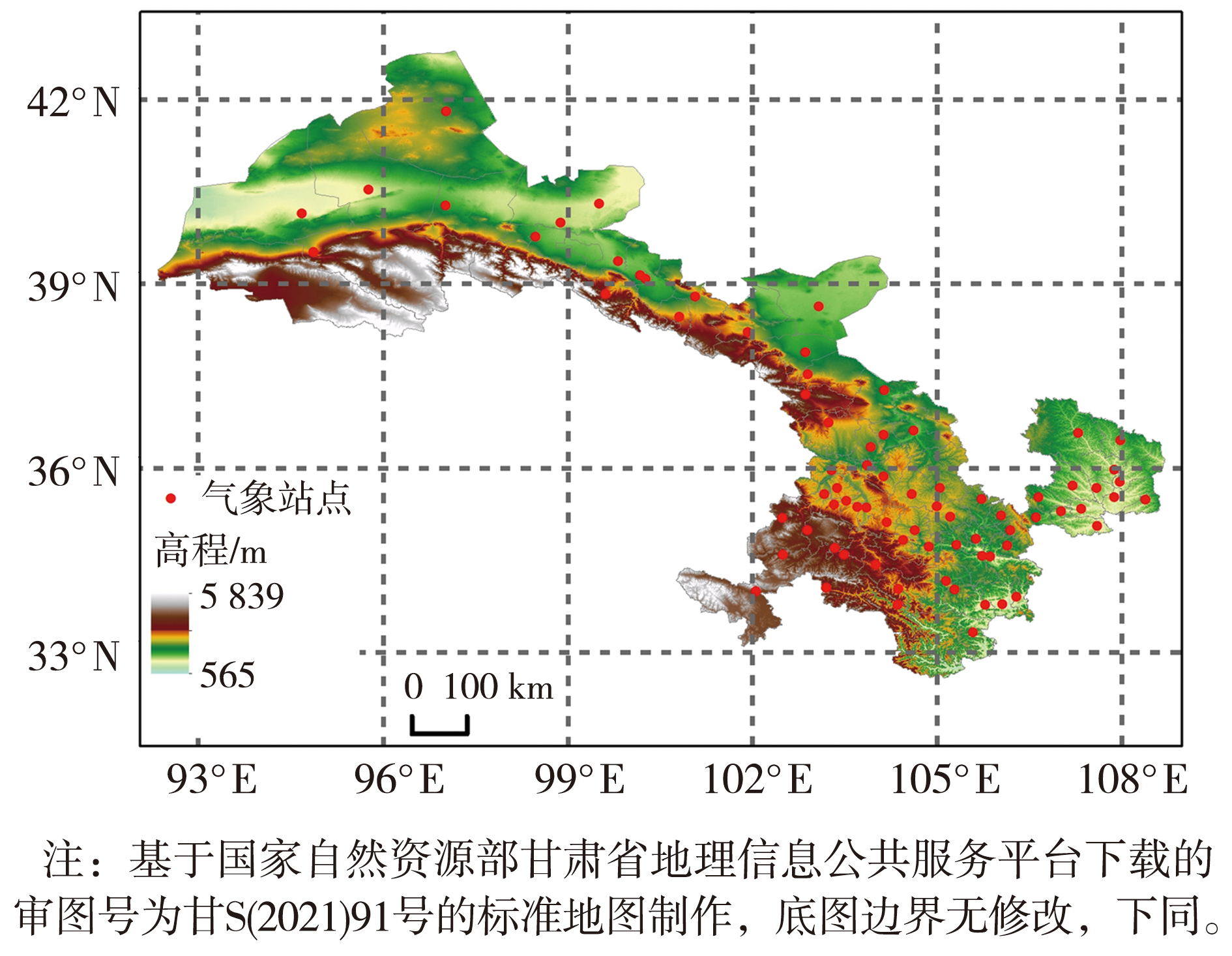
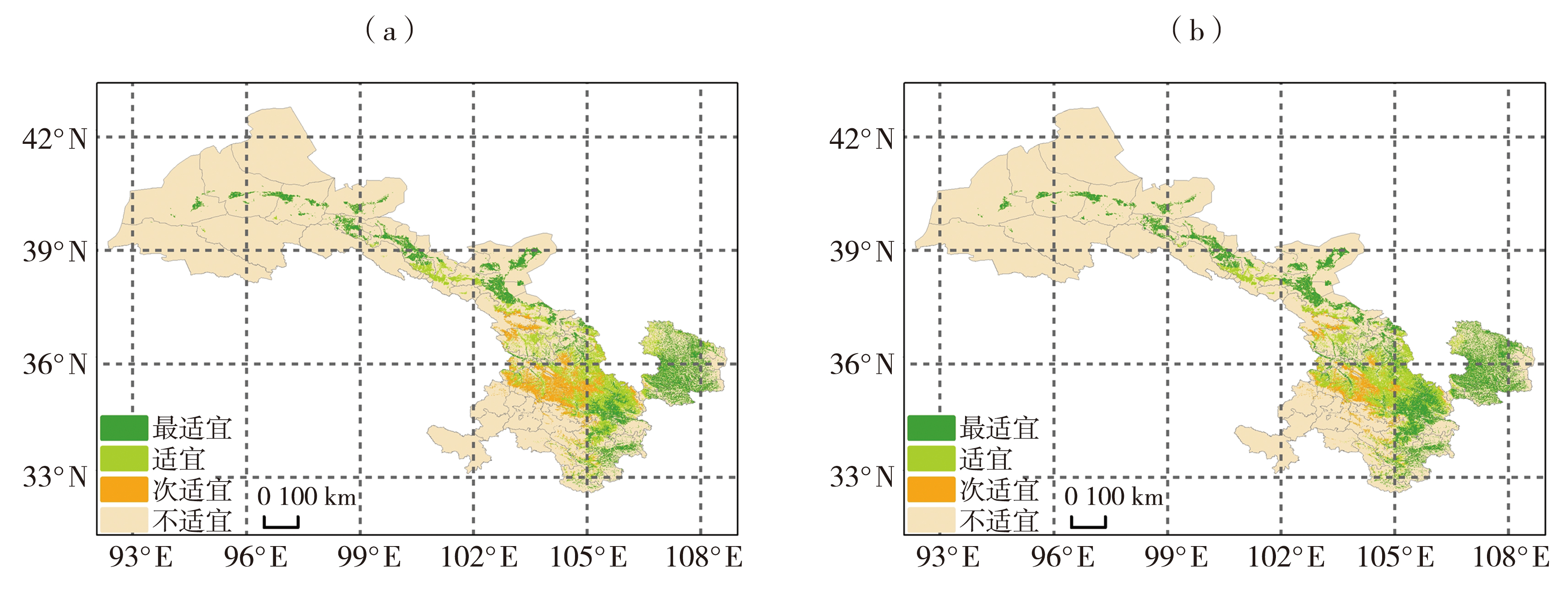
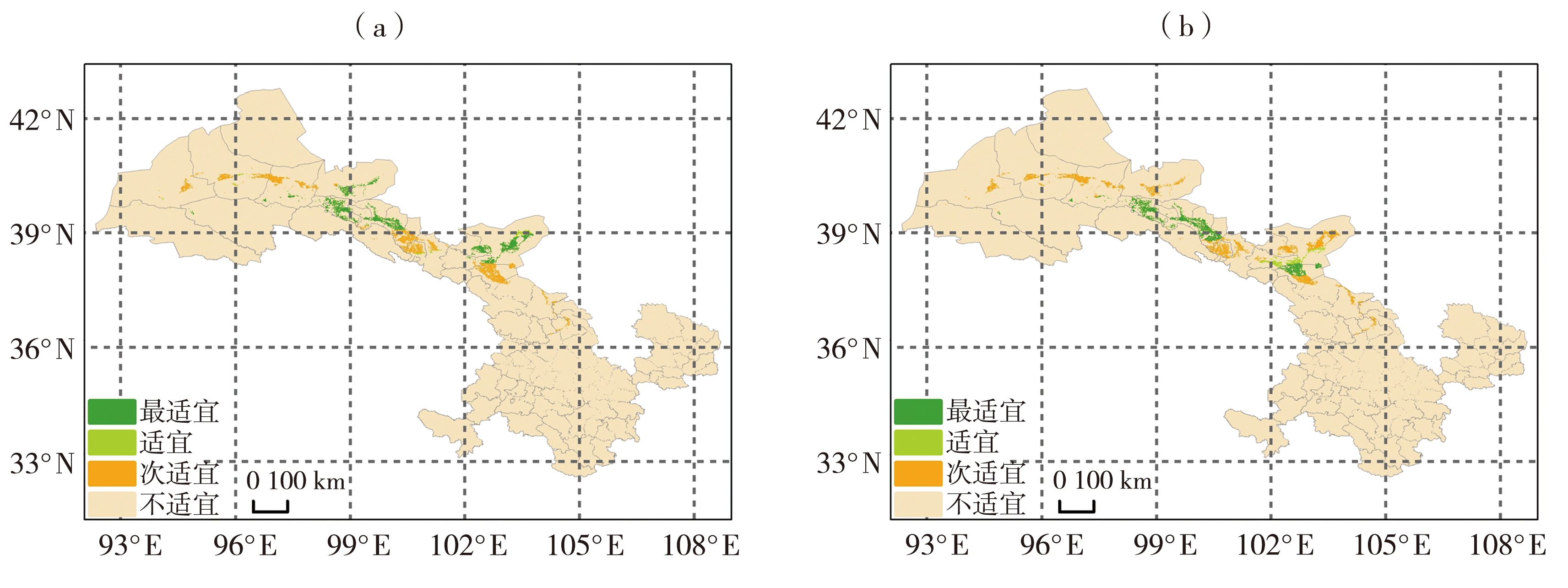
玉米是甘肃省主要粮食作物与特色制种产业支柱,开展春玉米与制种玉米气候适应性区划比较研究,对优化全省种植结构、保障粮食与种业安全具有重要现实意义。本文利用甘肃省1961—2020年80个国家级气象站点逐日观测资料、降尺度中国区域地面气象要素驱动数据集(China Meteorological Forcing Dataset, CMFD)高分辨率格点数据、数字高程模型(Digital Elevation Model, DEM)以及土地利用类型数据,以省内春玉米与制种玉米为研究对象,选取日平均气温≥10 ℃活动积温(简称≥10 ℃活动积温)、日照总时数、开花期平均气温、平均相对湿度及连阴雨、高温、霜冻灾害风险指数共7项核心区划指标,采用气候要素多元回归小网格空间推算、模糊隶属度函数及加权综合评判方法,分别开展甘肃省春玉米与制种玉米精细化气候适应性区划,并从指标体系构成、空间适宜格局及年代际变化特征开展系统比较分析。结果表明:春玉米与制种玉米采用相同的基础光温指标及单因子适宜阈值,二者区划的区域差异主要源于制种玉米湿度及气象灾害评价指标;春玉米气候适宜范围更广,在耕地范围内主要分布于河西大部、陇中北部、陇东及陇南区域;制种玉米受湿度条件与灾害风险双重约束,最适宜区仅集中分布于河西走廊中部地带。气候变暖背景下,区域热量资源明显增加,两类玉米适宜种植格局均出现等级跃迁,积温增加推动适宜区向高海拔及偏北区域扩展,而高温灾害风险加剧造成河西走廊西部制种玉米适宜性有所下降。

关键词: 春玉米, 制种玉米, 气候区划比较, 空间精细化, 种植格局

Abstract:

Maize is a major food crop and a key component of the specialized seed production industry in Gansu Province. A comparative study of the agroclimatic suitability zoning of spring maize and hybrid seed maize is of great practical significance for optimizing the provincial cropping structure and ensuring food and seed security. Based on daily observational data from 80 national meteorological stations in Gansu Province during 1961-2020, downscaled high-resolution gridded data from the China Meteorological Forcing Dataset (CMFD), digital elevation model (DEM) data, and land-use data, this study selected spring maize and hybrid seed maize in Gansu Province as the study subjects. Seven core zoning indicators were adopted, including active accumulated temperature of daily mean temperature ≥10 ℃ (hereafter referred to as active accumulated temperature≥10 ℃), total sunshine duration, mean air temperature during the flowering period, mean relative humidity, and risk indices for continuous rainy days, high temperature disasters, and frost disasters. Fine-grid spatial estimation of climatic elements based on multiple regression, fuzzy membership functions, and weighted comprehensive evaluation was employed to conduct refined agroclimatic suitability zoning for spring maize and hybrid seed maize in Gansu Province. Systematic comparative analyses were subsequently conducted in terms of the composition of the indicator systems, spatial patterns of climatic suitability, and interdecadal changes. The results show that the basic temperature and sunshine indicators and their single-factor suitability thresholds are consistent between spring maize and hybrid seed maize, whereas the differences in the zoning patterns are mainly attributable to the humidity and meteorological disaster indicators used for hybrid seed maize. Spring maize has a broader climatically suitable area, with the most suitable cropland mainly distributed in the Hexi Corridor, northern central Gansu, eastern Gansu, and southern Gansu. Hybrid seed maize is jointly constrained by humidity conditions and meteorological disaster risks, with the most suitable areas concentrated in the central part of the Hexi Corridor. Against the background of climate warming, regional thermal resources have increased substantially, and the suitability patterns of both maize types have shifted among suitability levels. The increase in accumulated temperature has promoted the expansion of suitable areas toward higher elevations and farther north, whereas increasing high temperature disaster risk has resulted in a decline in the climatic suitability of hybrid seed maize in the western Hexi Corridor.

Key words: spring maize, hybrid seed maize, comparative agroclimatic suitability zoning, spatial refinement, planting pattern

中图分类号: