Journal of Arid Meteorology ›› 2026, Vol. 44 ›› Issue (2): 273-284.DOI: 10.11755/j.issn.1006-7639-2026-02-0273
• Articles • Previous Articles Next Articles
Influence of terrain on lightning-ignited fires and prediction of firefighting factors based on NRBO-XGBoost in the Greater Khingan Mountains of Inner Mongolia
LIU Xiaodong1( ), HUANG Xingang2, LI Gang2(), WANG Guosheng3
- 1
Inner Mongolia Autonomous Region Climate Center Hohhot 010051, China
2College of Software ,Taiyuan University of Technology, Jinzhong 030600 Shanxi, China
3Xilingol League Meteorological Bureau ,Xilinhot 026000 Inner Mongolia, China
-
Received:2026-01-15Revised:2026-03-22Online:2026-05-20Published:2026-05-18
内蒙古大兴安岭地形对雷击火影响及基于NRBO-XGBoost的扑火因素预测
- 1
内蒙古自治区气候中心 内蒙古 呼和浩特 010051
2太原理工大学软件学院 山西 晋中 030600
3锡林郭勒盟气象局 内蒙古 锡林浩特 026000
-
通讯作者:李钢 -
作者简介:刘晓东(1981—),男,硕士,正高级工程师,主要从事气象灾害风险研究工作。E-mail: lxd8135@163.com。 -
基金资助:内蒙古自治区重点研发与成果转化计划项目(2025YFDZ0093)
CLC Number:
Cite this article
LIU Xiaodong, HUANG Xingang, LI Gang, WANG Guosheng. Influence of terrain on lightning-ignited fires and prediction of firefighting factors based on NRBO-XGBoost in the Greater Khingan Mountains of Inner Mongolia[J]. Journal of Arid Meteorology, 2026, 44(2): 273-284.
刘晓东, 黄薪钢, 李钢, 王国胜. 内蒙古大兴安岭地形对雷击火影响及基于NRBO-XGBoost的扑火因素预测[J]. 干旱气象, 2026, 44(2): 273-284.
share this article
Add to citation manager EndNote|Ris|BibTeX
URL: http://www.ghqx.org.cn/EN/10.11755/j.issn.1006-7639-2026-02-0273
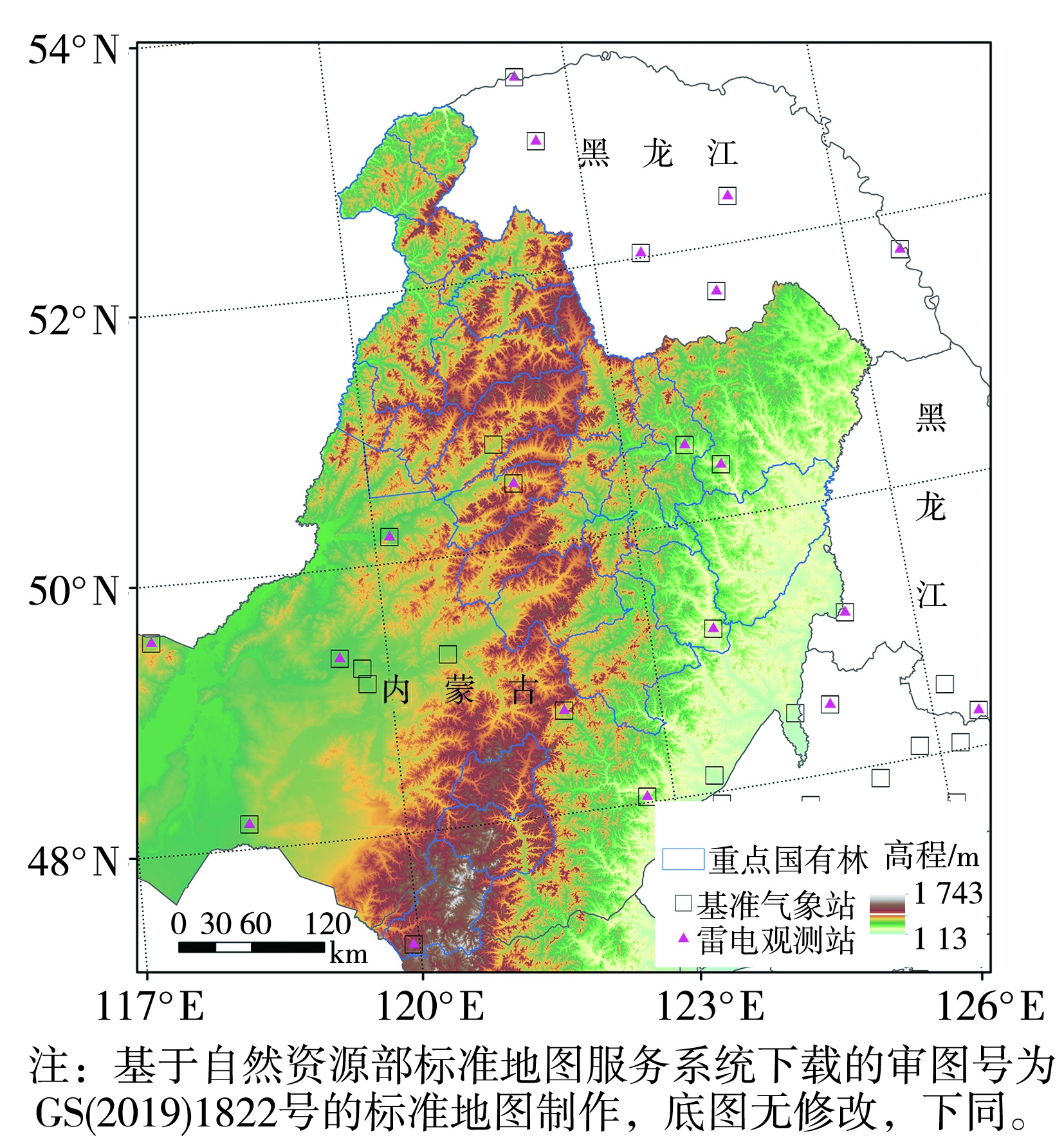
Fig.1 Topography of the study area and distribution of surrounding meteorological observation stations
Fig.1 Topography of the study area and distribution of surrounding meteorological observation stations
Tab.1 Classification of topographic factors in key state-owned forest areas of the Greater Khingan Mountains
| 地形因子 | 分级 | ||||||
|---|---|---|---|---|---|---|---|
| 1 | 2 | 3 | 4 | 5 | 6 | ||
| 高程/m | [200,500) | [500,1 000) | [1 000,1 500) | [1 500,2 000) | |||
| 坡度/(°) | [0,0.5) | [0.5,2) | [2,5) | [5,15) | [15,35) | [35,55) | |
| 地形起伏度/m | [0,20) | [20,75) | [75,200) | [200,600) | |||
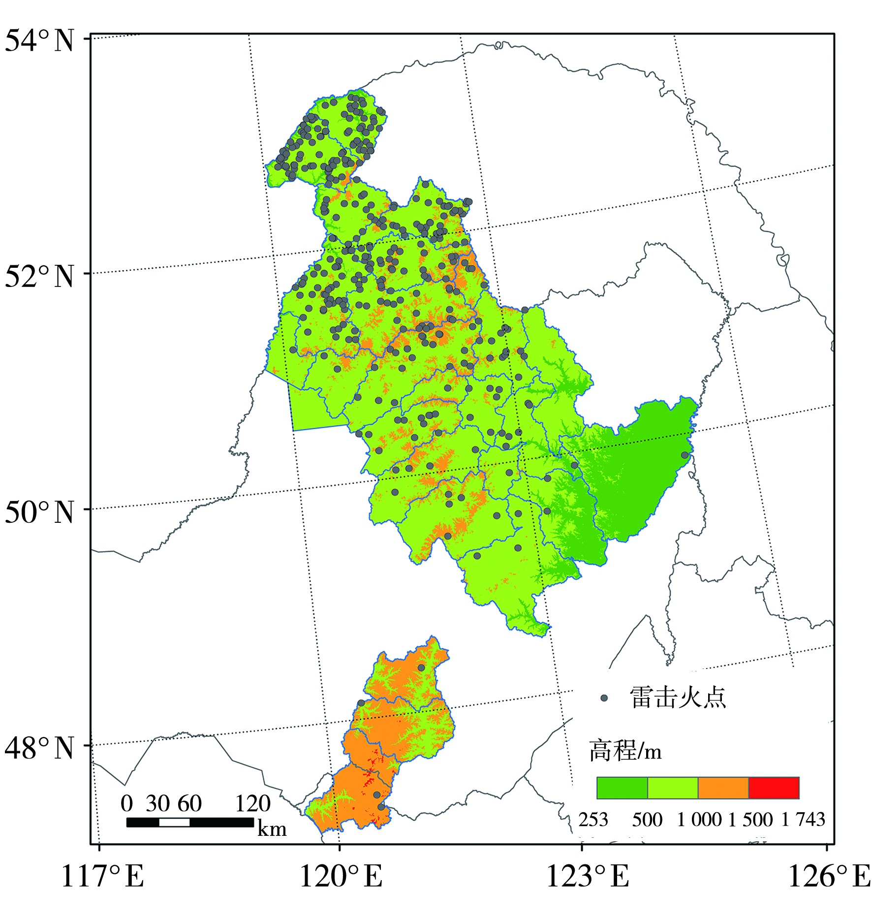
Fig.2 Spatial distribution of lightning-ignited fire points at different elevations
Fig.2 Spatial distribution of lightning-ignited fire points at different elevations
Tab.2 The proportion of lightning-ignited fire occurrences and burned areas in different elevation intervals
| 高程/m | 面积占比 | 雷击火灾次数占比 | 过火面积占比 |
|---|---|---|---|
| [200,500) | 13.80 | 2.69 | 4.02 |
| [500,1 000) | 68.73 | 83.06 | 76.34 |
| [1 000,1 500) | 17.32 | 14.25 | 19.64 |
| [1 500,2 000) | 0.15 | 0 | 0 |
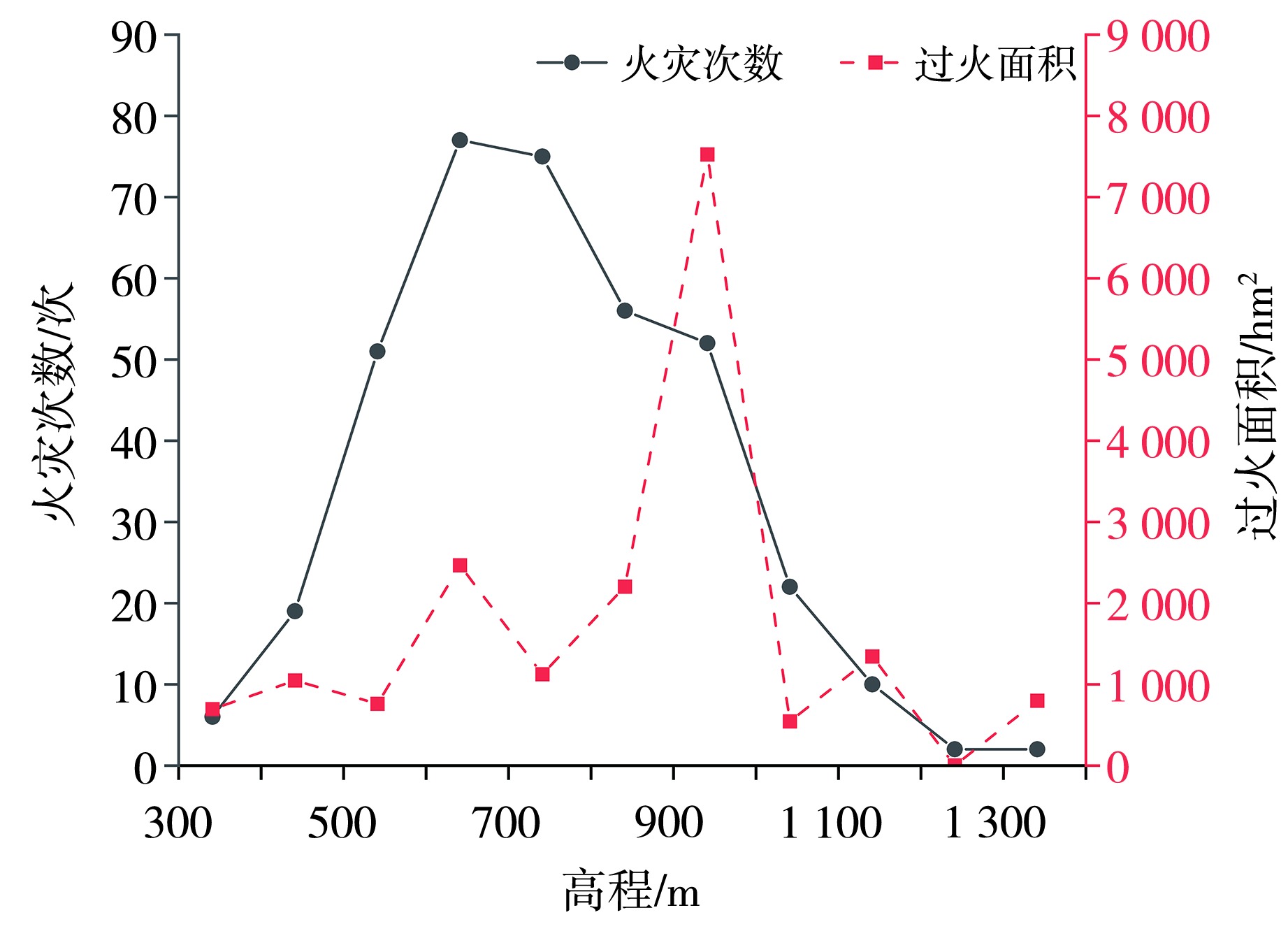
Fig.3 The variation of lightning-ignited fire occurrences and burned areas with elevation
Fig.3 The variation of lightning-ignited fire occurrences and burned areas with elevation
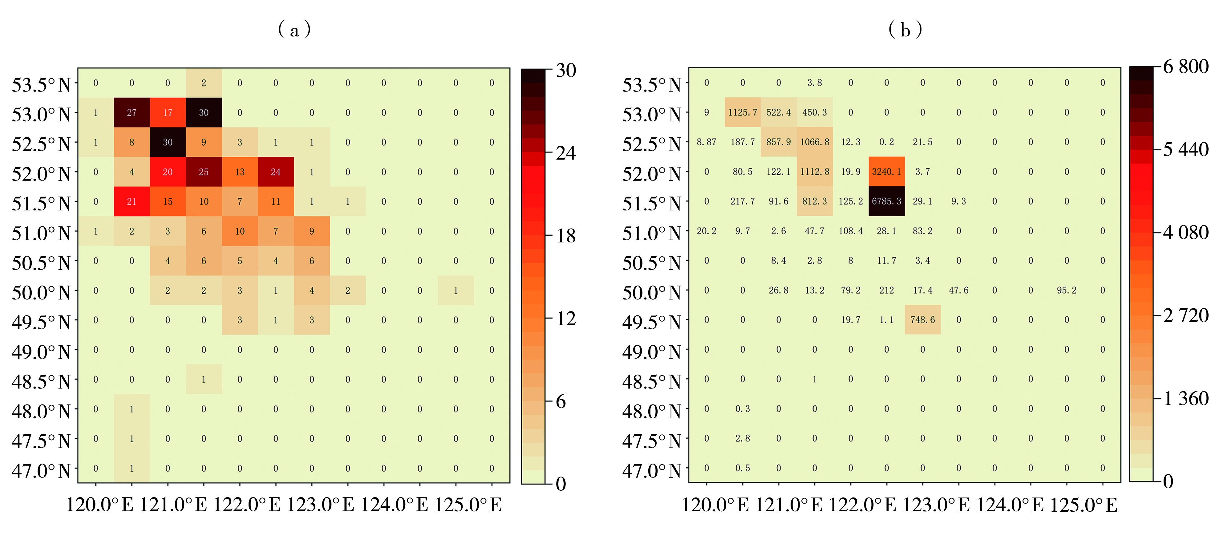
Fig.4 The heat maps of lightning-ignited fire occurrences (a, Unit: times) and burned areas (b, Unit: hm2)
Fig.4 The heat maps of lightning-ignited fire occurrences (a, Unit: times) and burned areas (b, Unit: hm2)
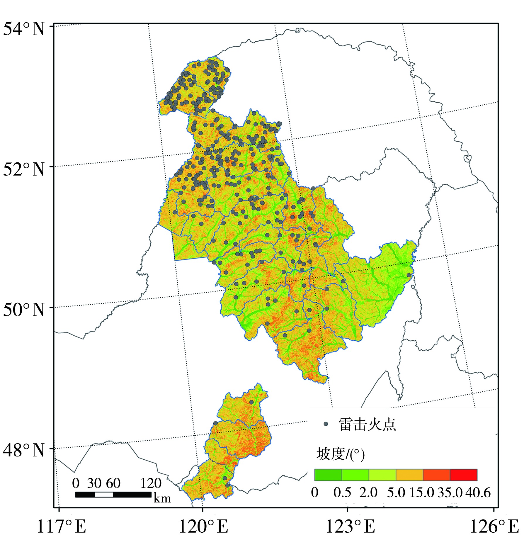
Fig.5 The spatial distribution of lightning-ignited fire points at different slopes
Fig.5 The spatial distribution of lightning-ignited fire points at different slopes
Tab.3 The proportion of lightning-ignited fire occurrences and burned areas in different slope intervals
| 坡度/(°) | 面积占比 | 雷击火灾次数占比 | 过火面积占比 |
|---|---|---|---|
| [0,0.5) | 4.05 | 2.69 | 4.49 |
| [0.5,2.0) | 11.97 | 7.26 | 2.01 |
| [2.0,5.0) | 21.58 | 17.47 | 37.83 |
| [5.0,15.0) | 52.87 | 56.72 | 51.37 |
| [15.0,35.0) | 9.53 | 15.86 | 4.30 |
| [35.0,55.0) | 0 | 0 | 0 |
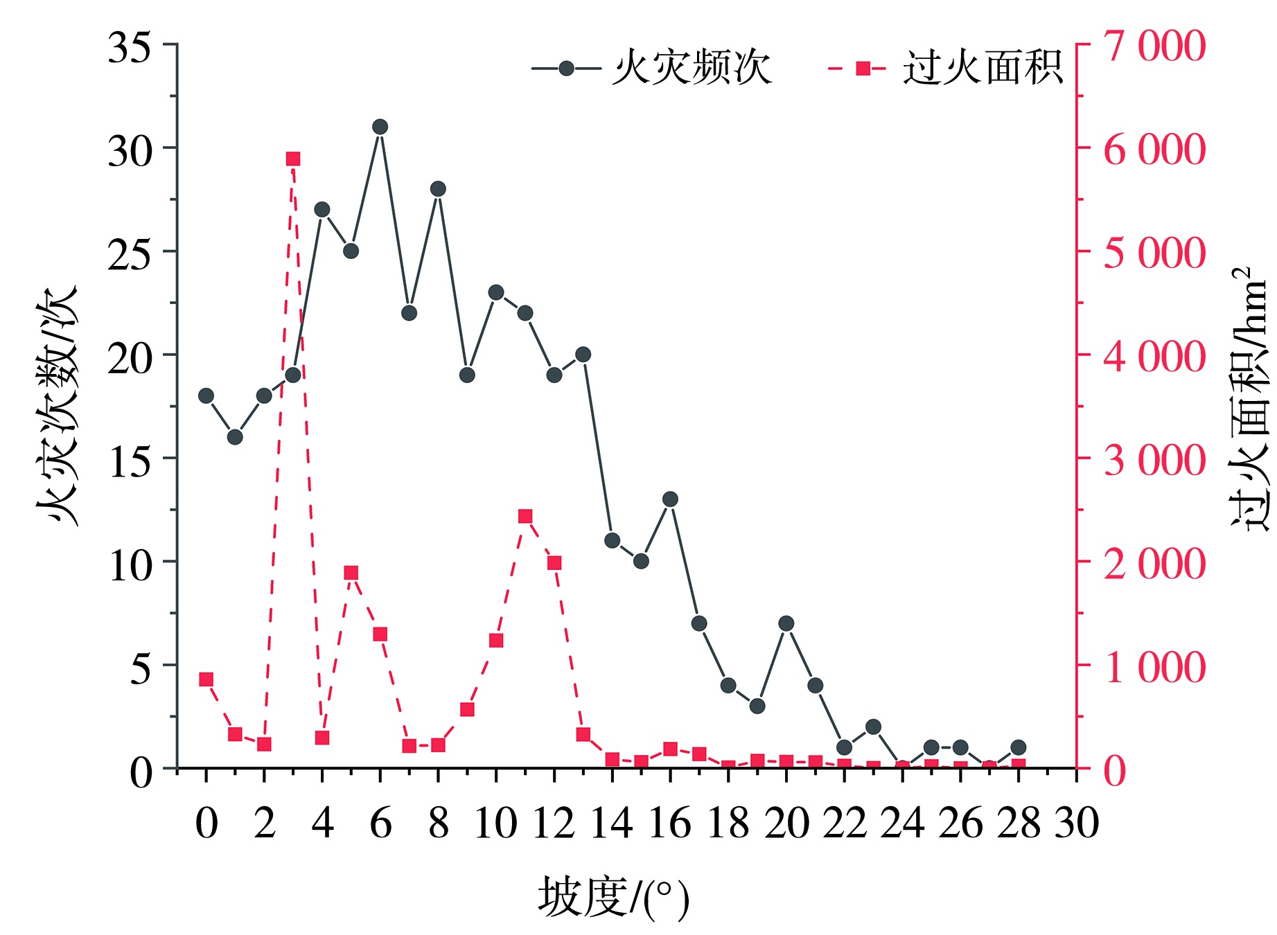
Fig.6 The change of lightning-ignited fire occurrences and burned areas with slope
Fig.6 The change of lightning-ignited fire occurrences and burned areas with slope

Fig.7 The spatial distribution of lightning-ignited fire points on different terrain relief degrees
Fig.7 The spatial distribution of lightning-ignited fire points on different terrain relief degrees
Tab.4 The proportion of lightning-ignited fire occurrences and burned areas across different topographic relief degree intervals
| 地形起伏度/m | 面积占比 | 雷击火灾次数占比 | 过火面积占比 |
|---|---|---|---|
| [0,20) | 7.96 | 5.65 | 2.14 |
| [20,75) | 30.45 | 19.62 | 38.48 |
| [75,200) | 59.41 | 70.97 | 47.67 |
| [200,600) | 2.18 | 3.76 | 11.71 |
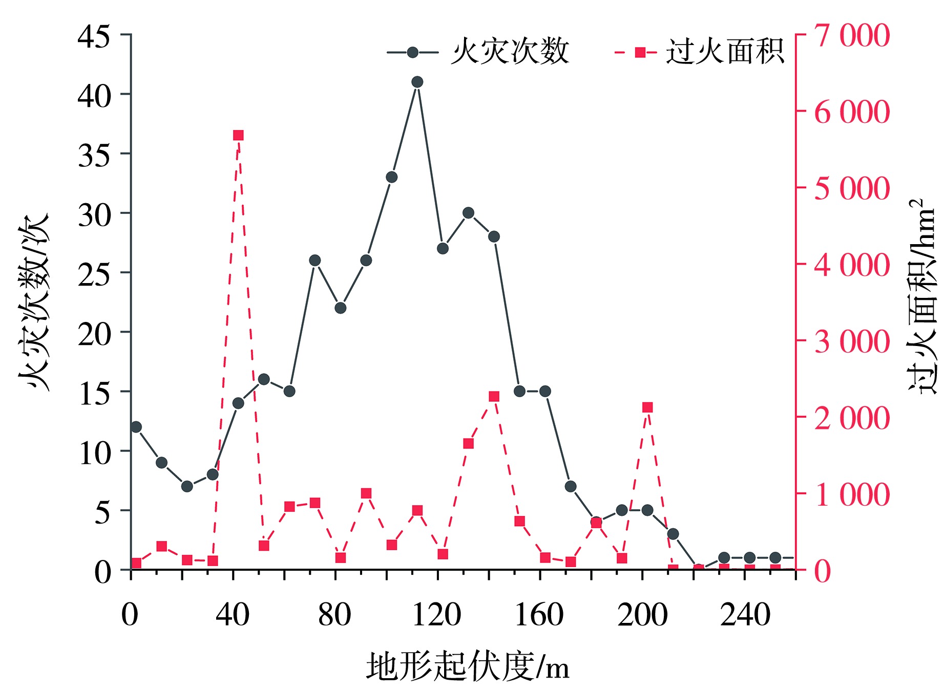
Fig.8 The variation of the number of lightning-ignited fires and burned area with terrain relief degree
Fig.8 The variation of the number of lightning-ignited fires and burned area with terrain relief degree

Fig.9 The spatial distribution of lightning-ignited fire points on different slope aspects
Fig.9 The spatial distribution of lightning-ignited fire points on different slope aspects
Tab.5 The proportion of the number of lightning-ignited fires and burned area on different slope aspects
| 坡向 | 面积占比 | 雷击火灾次数占比 | 过火面积占比 |
|---|---|---|---|
| 平地 | 0.59 | 0 | 0 |
| 北坡 | 11.37 | 5.65 | 16.20 |
| 东北坡 | 13.06 | 11.56 | 5.34 |
| 东坡 | 13.49 | 11.83 | 11.35 |
| 东南坡 | 12.50 | 15.59 | 11.53 |
| 南坡 | 11.78 | 16.67 | 4.81 |
| 西南坡 | 12.48 | 15.86 | 6.99 |
| 西坡 | 12.71 | 13.17 | 30.08 |
| 西北坡 | 12.03 | 9.68 | 13.69 |
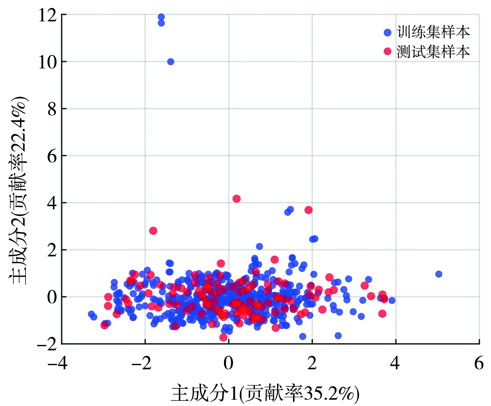
Fig.10 The principal component analysis of sample data
Fig.10 The principal component analysis of sample data
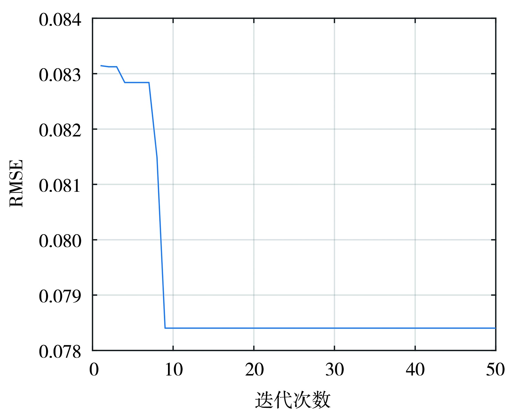
Fig.11 The optimization iteration curve
Fig.11 The optimization iteration curve
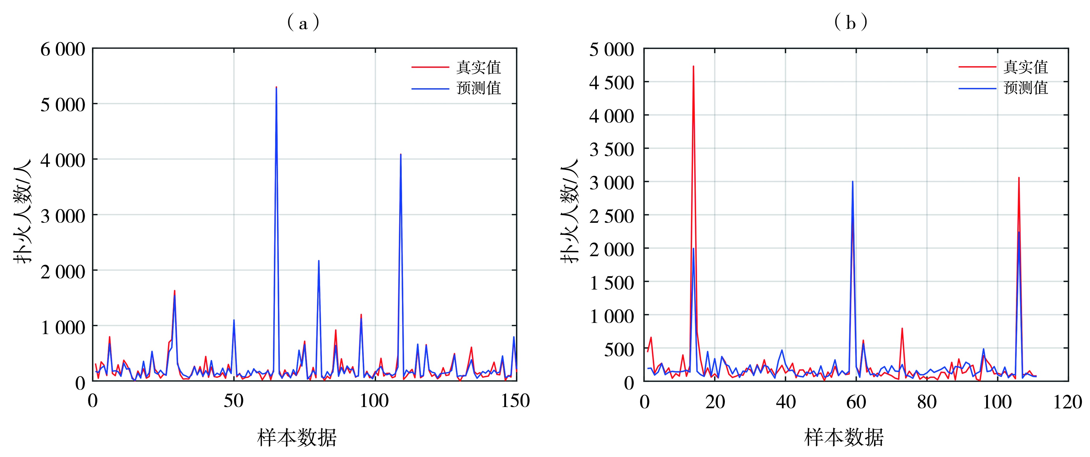
Fig.12 The prediction results of the model for the training set (a) and the test set (b)
Fig.12 The prediction results of the model for the training set (a) and the test set (b)
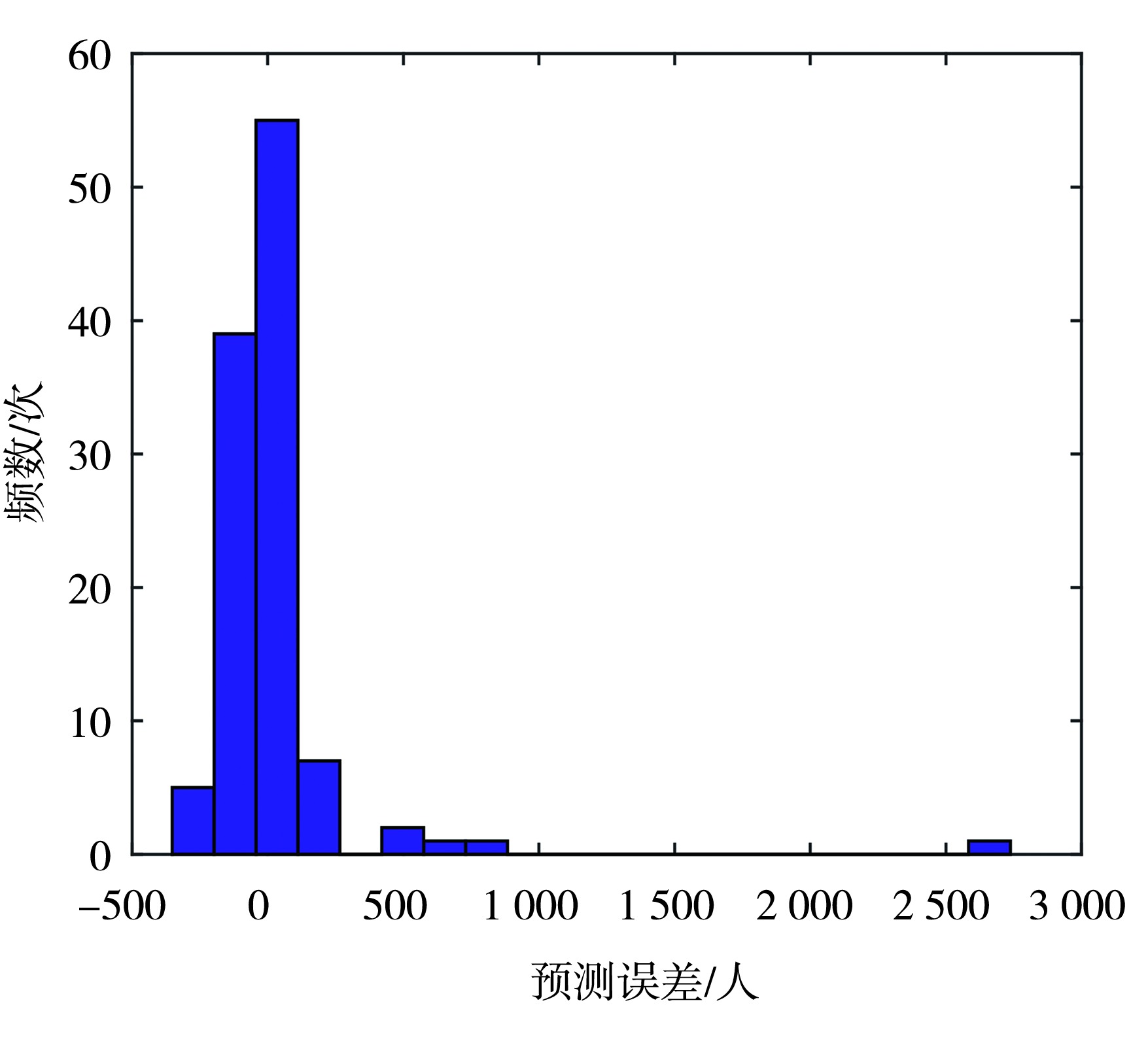
Fig.13 The histogram of prediction errors on the test set
Fig.13 The histogram of prediction errors on the test set
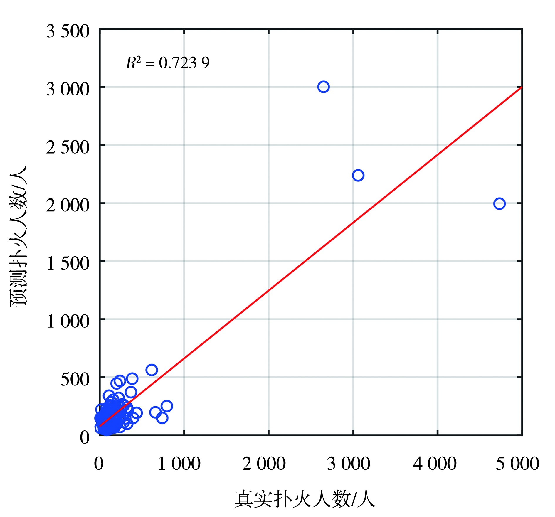
Fig.14 The R2plot of predictions on the test set
Fig.14 The R2plot of predictions on the test set
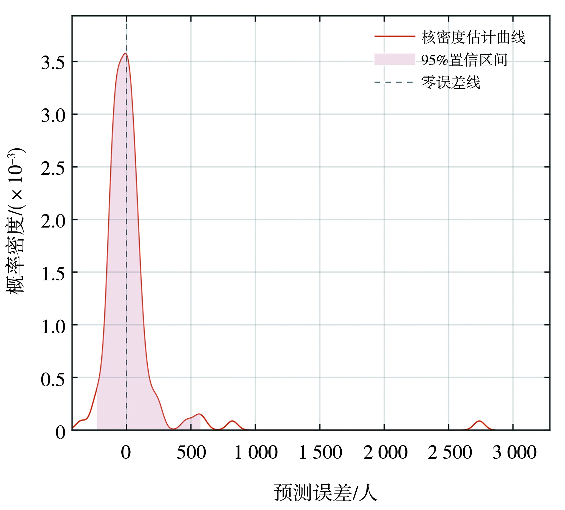
Fig.15 The kernel density estimation curve of interval prediction
Fig.15 The kernel density estimation curve of interval prediction
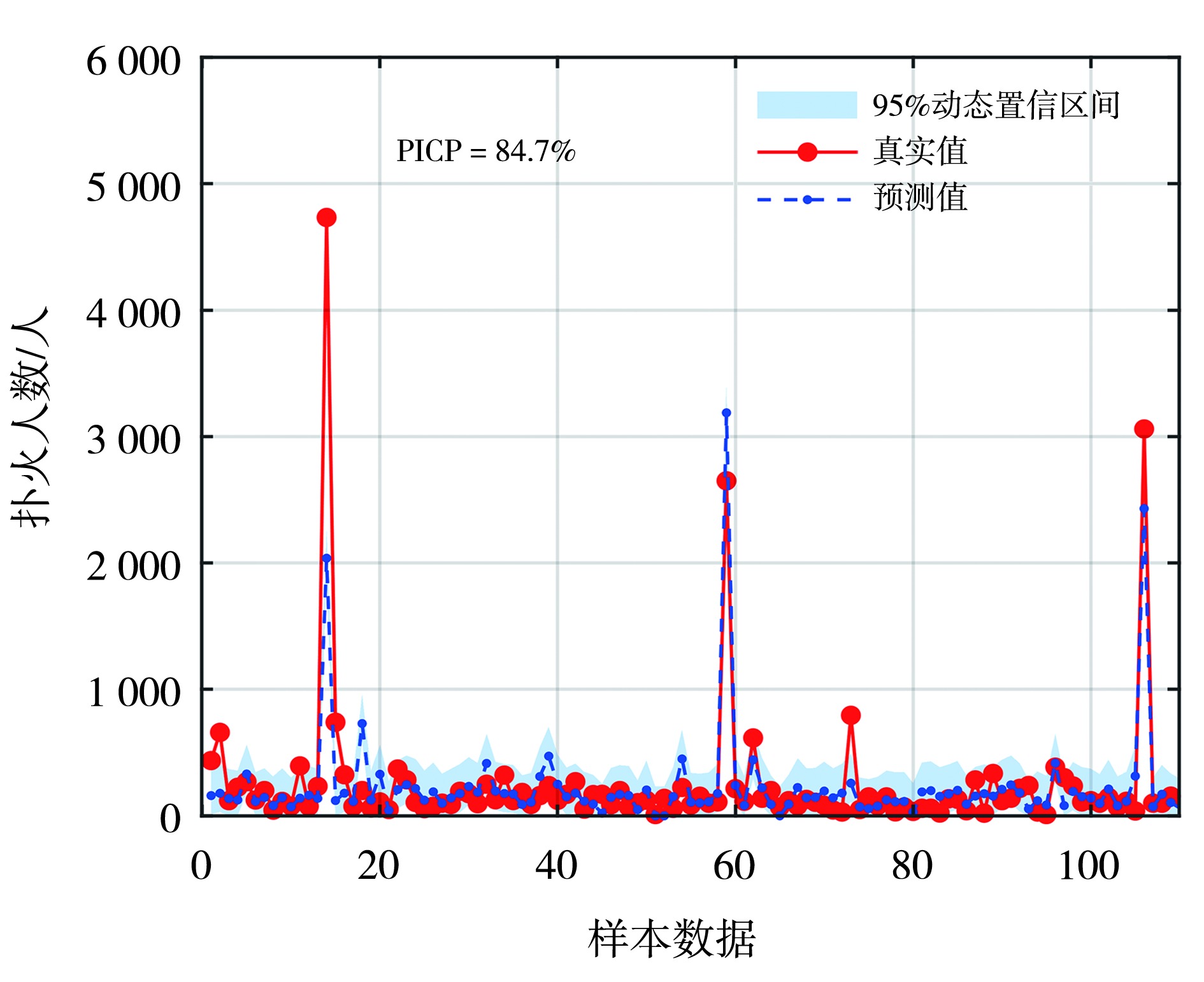
Fig.16 The interval prediction results
Fig.16 The interval prediction results
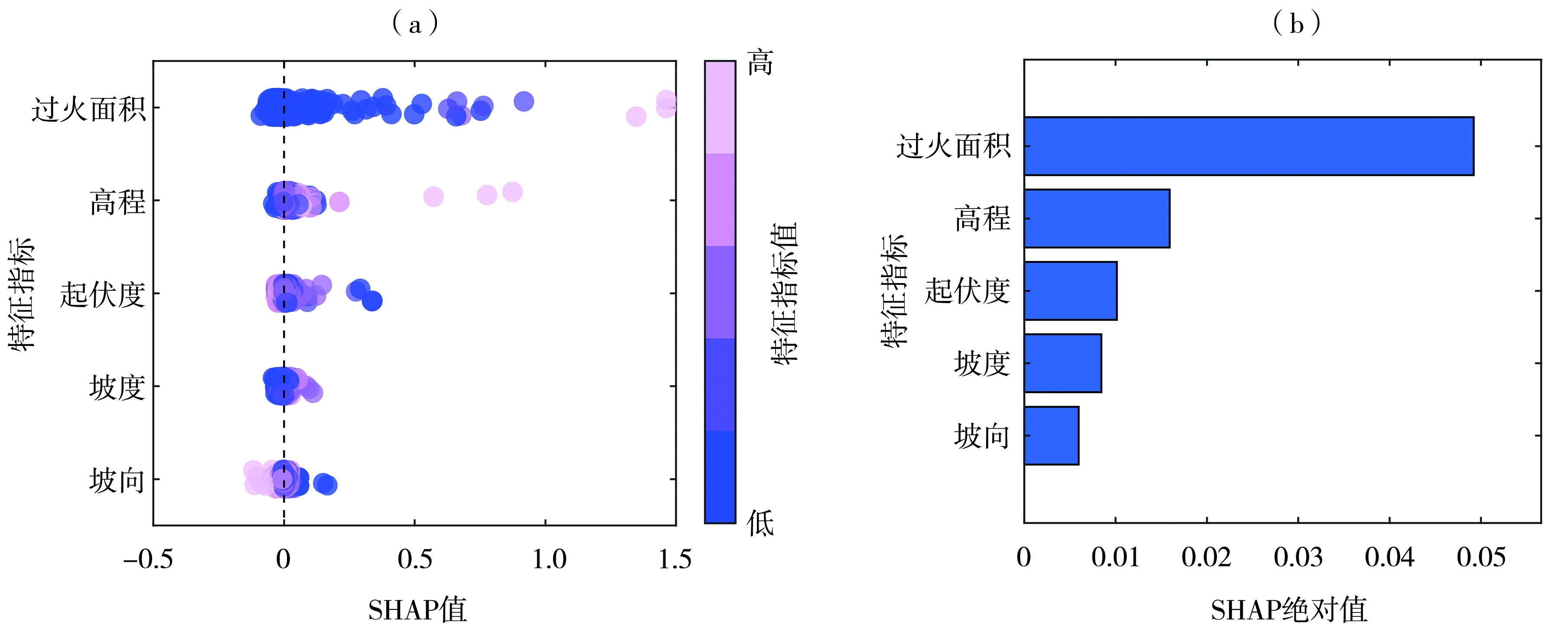
Fig.17 The SHAP value distribution (a) and importance ranking (b) of wildfire suppression influencing factors
Fig.17 The SHAP value distribution (a) and importance ranking (b) of wildfire suppression influencing factors
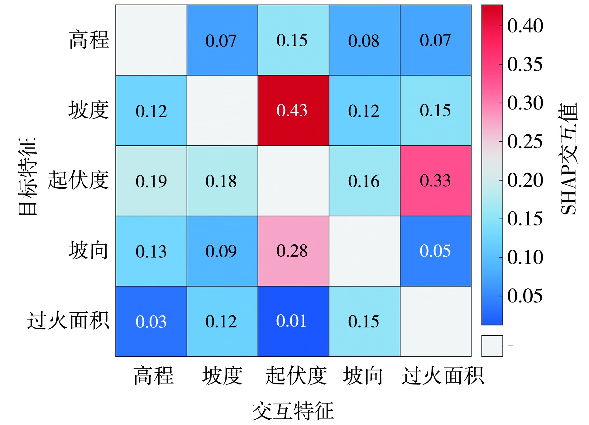
Fig.18 Global SHAP feature interaction matrix for wildfire suppression influencing factors
Fig.18 Global SHAP feature interaction matrix for wildfire suppression influencing factors
| [1] | 毕杰和, 2018. 内蒙古大兴安岭林区森林生态状况及保护建议[J]. 内蒙古林业调查设计, 41(6):6-8. |
| [2] | 焦强英, 韩宗甫, 王炜烨, 等, 2023. 基于多源数据和机器学习方法的大兴安岭地区雷击火驱动因子及火险预测模型[J]. 林业科学, 59(6):74-87. |
| [3] | 李婧, 2022. 内蒙古大兴安岭林火时空分布及火险区划[D]. 呼和浩特: 内蒙古农业大学. |
| [4] | 李威, 舒立福, 王明玉, 等, 2023. 大兴安岭1980—2021年雷击火时空分布特征[J]. 林业科学, 59(10):22-31. |
| [5] | 刘爱利, 2004. 基于1:100万DEM的我国地形地貌特征研究[D]. 西安: 西北大学. |
| [6] | 刘晓东, 冯旭宇, 李庆君, 等, 2021. 内蒙古地形因素对雷电灾害的影响及其权重分析[J]. 科学技术与工程, 21(3):899-905. |
| [7] | 刘晓东, 冯旭宇, 刘旭洋, 等, 2020. 内蒙古雷击人员伤亡特征及其致灾因素的熵权分析[J]. 中国安全生产科学技术, 16(4):182-188. |
| [8] | 倪长虹, 邸雪颖, 2009. 黑龙江省大兴安岭雷击火发生规律[J]. 东北林业大学学报, 37(1):55-57. |
| [9] |
聂卉, 吴晓燕, 2024. 结合梯度提升树算法与可解释机器学习模型SHAP的抑郁症影响因素研究[J]. 数据分析与知识发现, 8(3):41-52.
DOI |
| [10] | 田晓瑞, 舒立福, 王明玉, 等, 2009. 大兴安岭雷击火时空分布及预报模型[J]. 林业科学研究, 22(1):14-20. |
| [11] | 田晓瑞, 舒立福, 赵凤君, 等, 2012. 大兴安岭雷击火发生条件分析[J]. 林业科学, 48(7):98-103. |
| [12] | 万雨勤, 仝纪龙, 刘永乐, 等, 2026. 基于XGBoost算法量化气象要素对兰州市主城区夏季臭氧浓度的影响[J]. 环境科学, 47(1):223-232. |
| [13] | 杨腾杰, 高新强, 杨志国, 等, 2025. 基于NRBO-XGBoost和ABKDE融合可解释模型的TBM掘进速度预测[J]. 河南科技大学学报:自然科学版, 46(4):73-87. |
| [14] | 岳永杰, 韩军, 李玉柱, 等, 2013. 内蒙古大兴安岭森林涵养水源和保育土壤功能评估[J]. 中南林业科技大学学报, 33(12):91-95. |
| [15] | 张冬有, 邓欧, 李亦秋, 等, 2012. 黑龙江省1980—2005年森林火灾时空特征[J]. 林业科学, 48(2):175-179. |
| [16] | 赵凤君, 舒立福, 邸雪颖, 等, 2009. 气候变暖背景下内蒙古大兴安岭林区森林火灾发生日期的变化[J]. 林业科学, 45(6):166-172. |
| [17] | 赵俊卉, 郭广猛, 亢新刚, 等, 2008. 基于LIS/OTD格点数据的中国东北地区雷击火时空分布原因分析[J]. 内蒙古农业大学学报:自然科学版, 29(3):49-54. |
| [18] | 赵俊卉, 亢新刚, 郭广猛, 等, 2009. 基于LIS/OTD格点数据的中国东北地区雷击火时空分布[J]. 生态学杂志, 28(4): 715-720. |
| [19] | 周梅, 2003. 大兴安岭落叶松林生态系统水文过程与规律研究[D]. 北京: 北京林业大学. |
| [20] | ABATZOGLOU J T, WILLIAMS A P, 2016. Impact of anthropogenic climate change on wildfire across western US forests[J]. Proceedings of the National Academy of Sciences of the United States of America, 113(42): 11 770-11 775. |
| [21] |
BOWMAN D M J S, BALCH J K, ARTAXO P, et al, 2009. Fire in the Earth system[J]. Science, 324(5926): 481-484.
DOI PMID |
| [22] | CHEN F, DU Y S, NIU S K, et al, 2015. Modeling forest lightning fire occurrence in the Daxinganling Mountains of northeastern China with MAXENT[J]. Forests, 6(5): 1 422-1 438. |
| [23] |
COCHRANE M A, MORAN C J, WIMBERLY M C, et al, 2012. Estimation of wildfire size and risk changes due to fuels treatments[J]. International Journal of Wildland Fire, 21(4): 357-367.
DOI URL |
| [24] | DU Y, LI S, FENG P, et al, 2021. Dynamic risk assessment of wildfire based on integrating multi-source data and a random forest algorithm: A case study of Chongqing, China[J]. Natural Hazards, 108(1): 1 071-1 090. |
| [25] |
GUO F T, WANG G Y, INNES L, et al, 2016. Comparison of six generalized linear models for occurrence of lightning-induced fires in northern Daxing’an Mountains, China[J]. Journal of Forestry Research, 27(2): 379-388.
DOI URL |
| [26] |
HEYERDAHL E K, BRUBAKER L B, AGEE J K, 2001. Spatial controls of historical fire regimes: A multiscale example from the interior west, USA[J]. Ecology, 82(3): 660-678.
DOI URL |
| [27] |
JAIN P, COOGAN S C P, SUBRAM-ANIAN S G, et al, 2020. A review of machine learning applications in wildfire science and management[J]. Environmental Reviews, 28(4): 478-505.
DOI URL |
| [28] |
JOLLY W M, COCHRANE M A, FREEBORN P H, et al, 2015. Climate-induced variations in global wildfire danger from 1979 to 2013[J]. Nature Communications, 6: 7537. DOI: 10.1038/ncomms7537.
PMID |
| [29] |
LUNDBERG S M, ERION G, CHEN H, et al, 2020. From local explanations to global understanding with explainable AI for trees[J]. Nature Machine Intelligence, 2(1): 56-67.
DOI PMID |
| [30] | NARAYANARAJ G, WIMMERS M T, 2012. Modeling the influence of topographic roughness on fire spread[J]. Environmental Modelling & Software, 38: 290-302. |
| [31] | PARKS S A, PARISIEN M A, MILLER C, 2012. Spatial bottom-up controls on fire likelihood vary across western North America[J]. Ecosphere, 3(1): 1-20. |
| [32] |
RODRIGUES M, DE LA RIVA J, FOTHERINGHAM S, 2014. Modeling the spatial variation of the explanatory factors of human-caused wildfires in Spain using geographically weighted logistic regression[J]. Applied Geography, 48: 52-63.
DOI URL |
| [33] | ROTHERMEL R C, 1972. A mathematical model for predicting fire spread in wildland fuels[R]. Ogden: USDA Forest Service, Intermountain Forest and Range Experiment Station, 1-52. |
| [34] |
RUDIN C, 2019. Stop explaining black box machine learning models for high stakes decisions and use interpretable models instead[J]. Nature Machine Intelligence, 1(5): 206-215.
DOI PMID |
| [35] | SONG S D, ZHOU X, YUAN S B, et al, 2025. Interpretable artificial intelligence models for predicting lightning prone to inducing forest fires[J]. Journal of Atmospheric and Solar-Terrestrial Physics, 267: 106408. DOI:10.1016/j.jastp.2024.106408. |
| [36] | SOWMYA R, PREMKUMAR M, JANGIR P, 2024. Newton-Raphson-based optimizer: A new population-based metaheuristic algorithm for continuous optimization problems[J]. Engineering Applications of Artificial Intelligence, 128:107532. DOI:1016/j.engappai.2023.107532. |
| [37] |
SYPHARD A D, RADELOFF V C, KEULER N S, et al, 2008. Predicting spatial patterns of fire on a southern California landscape[J]. International Journal of Wildland Fire, 17(5): 602-613.
DOI URL |
| [38] | YUE W T, REN C, LIANG Y J, et al, 2023. Assessment of wildfire susceptibility and wildfire threats to ecological environment and urban development based on GIS and multi-source data: A case study of Guilin, China[J]. Remote Sensing, 15(10): 2659. DOI:10.3390/rs15102659. |
| Viewed | ||||||
|
Full text |
|
|||||
|
Abstract |
|
|||||