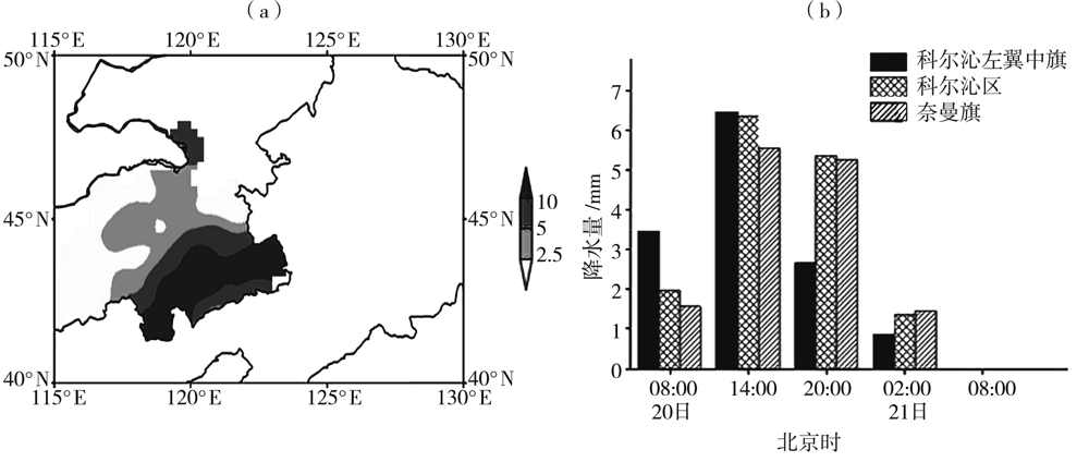
| [1] |
CRISP CA, LEWIS J M. Return flow in the Gulf of Mexico.Part I: a classificatory approach with a global historical perspective[J]. Journal of Applied Meteorology, 1992, 31(8):868-881.
DOI
URL
|
| [2] |
王文波, 高晓梅, 李晓利,等. 一次雨雪天气过程的风廓线雷达特征[J]. 干旱气象, 2020, 38(1):109-116.
|
| [3] |
翟亮, 郭淳薇, 马新成,等. 北京2016年“11·20”初雪预报偏差分析[J]. 气象, 2018, 44(1):151-158.
|
| [4] |
胡顺起, 曹张驰, 陈滔. 山东省南部一次极端特大暴雪过程诊断分析[J]. 高原气象, 2017, 36(4):984-992.
DOI
|
| [5] |
赵桂香. 诊断分析技术在山西强降雪预报中的应用[J]. 高原气象, 2014, 33(3):838-847.
DOI
|
| [6] |
王玉亮, 胡顺起. 1999—2018年鲁南地区暴雪天气的影响系统及环流特征[J]. 沙漠与绿洲气象, 2019, 13(3):8-15.
|
| [7] |
张芹, 丁治英, 杨成芳,等. 山东一次历史极端降雪过程的诊断分析[J]. 高原气象, 2015, 34(4):1131-1138.
DOI
|
| [8] |
李青春, 程丛兰, 高华,等. 北京一次冬季回流暴雪天气过程的数值分析[J]. 气象, 2011, 37(11):1380-1388.
|
| [9] |
张南, 张迎新, 申莉莉. 冀中南一次春季雨雪过程诊断与预报技术分析[J]. 干旱气象, 2014, 32(4):622-628.
|
| [10] |
阎琦, 崔锦, 杨青. 2018年辽宁两次雨转暴雪过程对比分析[J]. 干旱气象, 2019, 37(6):944-953.
|
| [11] |
张迎新, 侯瑞钦, 张守保. 回流暴雪过程的诊断分析和数值试验[J]. 气象, 2007, 33(9):25-32.
|
| [12] |
卢秉红, 杨青, 高松影,等. 两次不同类型暴雪的雷达回波特征分析[J]. 干旱气象, 2016, 34(5):836-840.
|
| [13] |
郑丽娜, 杨成芳, 刘畅. 山东冬半年回流降雪形势特征及相关降水相态[J]. 高原气象, 2016, 35(2): 520-527.
DOI
|
| [14] |
宫德吉. 内蒙古的暴风雪灾害及其形成过程的研究[J]. 气象, 2001, 27(8):19-23.
|
| [15] |
韩经纬, 李彰俊, 石少宏,等. 内蒙古大(暴)雪天气的卫星云图特征[J]. 自然灾害学报, 2005, 14(3):250-259.
|
| [16] |
姜学恭, 李彰俊, 康玲,等. 北方一次强降雪过程的中尺度数值模拟[J]. 高原气象, 2006, 25(3):476-483.
|
| [17] |
孟雪峰, 孙永刚, 姜艳丰. 内蒙古东北部一次致灾大到暴雪天气分析[J]. 气象, 2012, 38(7):877-883.
|
| [18] |
张桂莲, 姚晓娟, 孙永刚,等. 大兴安岭地区的一次暴雪天气诊断分析[J]. 气象科技, 2018, 46(5):971-978.
|
| [19] |
陶祖钰. 基础理论与预报实践[J]. 气象, 2011, 37(2):129-135.
|
| [20] |
董啸, 周顺武, 胡中明,等. 近50年来东北地区暴雪时空分布特征[J]. 气象, 2010, 36(12):74-79.
|
| [21] |
秦华锋, 金荣花. “0703”东北暴雪成因的数值模拟研究[J]. 气象, 2008, 34(4):30-38.
|
| [22] |
吴庆梅, 杨波, 王国荣. 北京地区一次回流暴雪过程的锋区特征分析[J]. 高原气象, 2014, 33(2):539-547.
DOI
|
| [23] |
刘畅, 杨成芳. 山东省极端降雪天气事件特征分析[J]. 干旱气象, 2017, 35(6):957-667.
|
 ), LIU Lanbo2, MENG Xuefeng1, ZHANG Lu1, LI Linhui3