Journal of Arid Meteorology ›› 2021, Vol. 39 ›› Issue (5): 796-806.DOI: 10.11755/j.issn.1006-7639(2021)-05-0796

• Articles • Previous Articles     Next Articles

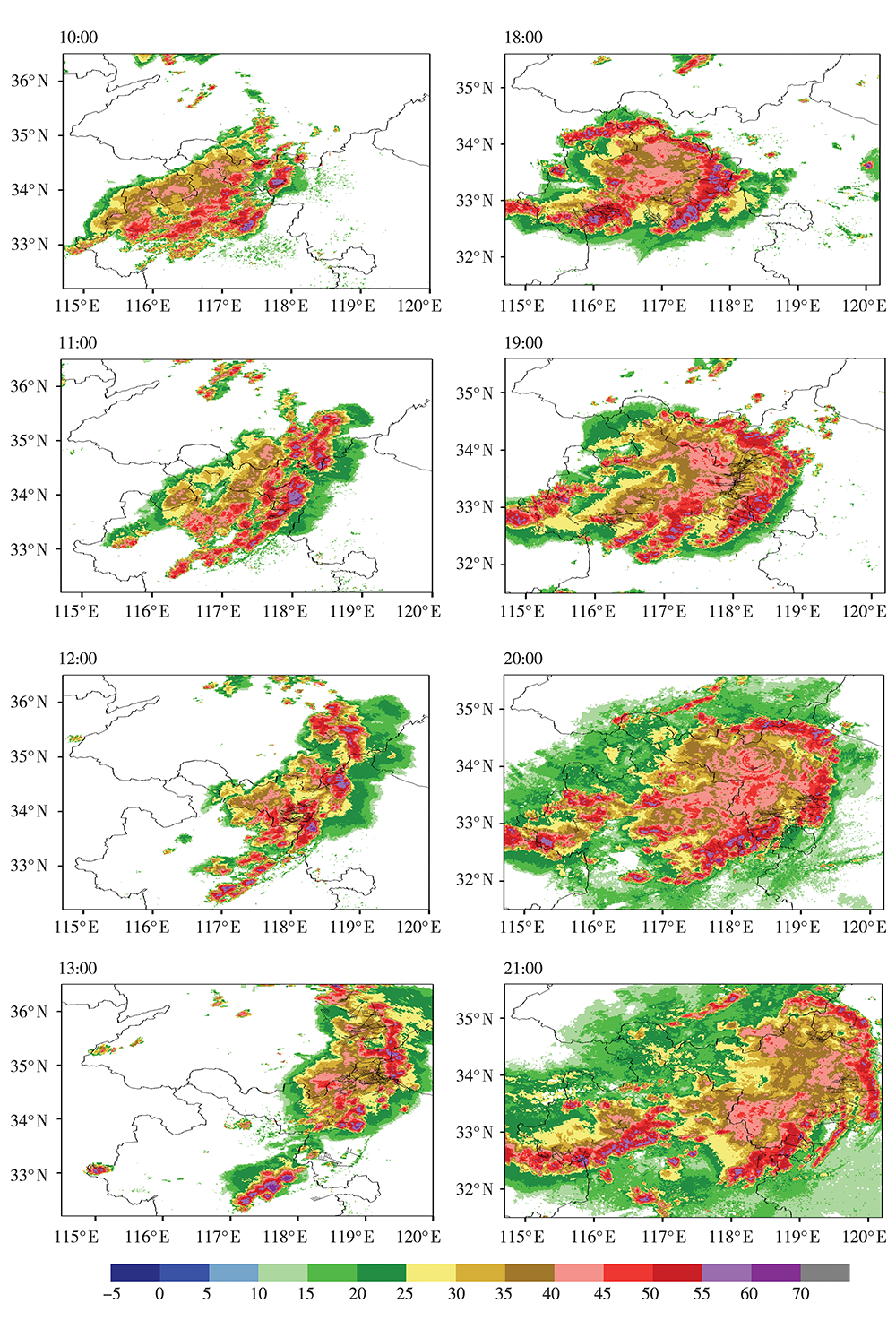
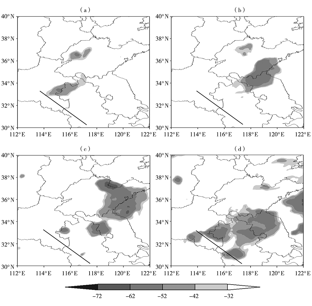
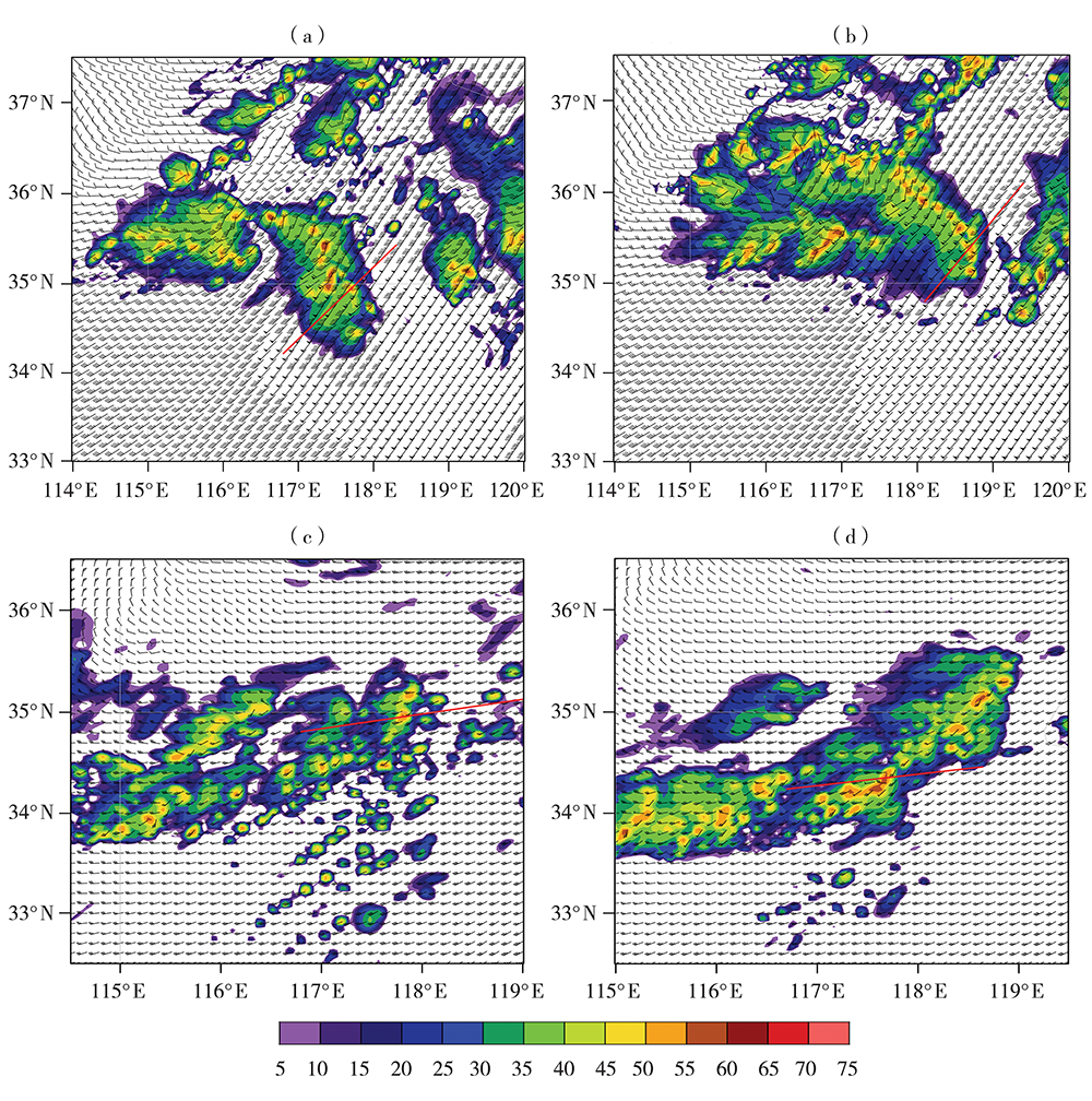
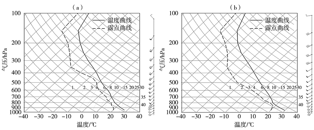
Comparative Analysis of Causes of Two Consecutive Squall Line Gales

ZHU Li1,2(),LU Dequan1,2(),LIAO Wenchao1,2,ZHENG Linlin3   

  1. 1. Heavy Rain and Drought-Flood Disasters in Plateau and Basin Key Laboratory of Sichuan Province, Chengdu 610072, China
    2. Severe Weather in Northeast Sichuan Key Laboratory of Nanchong City, Nanchong 637000, Sichuan, China
    3. Institute of Meteorological Science of Anhui Province, Hefei 230031, China
  • Received:2020-09-09 Revised:2021-03-19 Online:2021-10-30 Published:2021-11-08
  • Contact: Dequan LU

连续两次飑线大风成因对比分析

竹利1,2(),卢德全1,2(),廖文超1,2,郑淋淋3   

  1. 1.高原与盆地暴雨旱涝灾害四川省重点实验室,四川 成都 610072
    2.川东北强天气研究南充市重点实验室,四川 南充 637000
    3.安徽省气象科学研究所,安徽 合肥 230031
  • 通讯作者: 卢德全
  • 作者简介:竹利(1983— ),男,高级工程师,主要从事短临预报技术以及雷达资料应用的研究. E-mail: 275551265@qq.com
  • 基金资助:
    高原与盆地暴雨旱涝灾害四川省重点实验室青年专项(SCQXKJQN2020003);南充市科技计划项目(21YFZJ0028)

Abstract:

Based on multi-source meteorological observation data, the two consecutive squall line processes in the northern Jiangsu Province on May 16, 2018 were studied by using comprehensive observational comparative analysis and numerical simulation. The results are as follows: (1) The two squall line processes were generated in different environmental fields, but under the influence of the same weather system. The leeward wave disturbance on the leeward side of the Dabie mountains was the common trigger mechanism of the two squall lines. (2) The two processes had the same characteristics of the rear inflow jet and mid-altitude radial convergence on the radar echo images. For the first process, the rear inflow jet was stronger and higher, and the mid-altitude radial convergence was stronger and thicker. The difference in the vertical shear of the ambient wind was the main impact factor which led to the difference of the structural characteristics of the two squall lines. (3) Under the condition of similar convective available potential energy, the richer water vapor condition, the stronger vertical wind shear and the higher vertical shear extension height in the first process were beneficial to development of squall line system. (4) The main physical mechanisms for the formation of the two squall line gales were different. The inflow jet at the rear of the first squall line guided the mid-and high-level (5-8 km) dry and warm air to sink and intrude into the storm body, prompting its precipitation particles to evaporate strongly, and the cold pool was formed. At the same time, the high-level momentum was guided downward to produce a strong outflow airflow, which eventually led to the formation of ground gale. The inflow jet at the rear of the second squall line guided the low-and middle-level (3-5 km) dry and cold air to invade the convective system, forming cold pool and strong wind on the ground. (5) The structural characteristics of the squall line formed under the vertical wind shear condition of the environmental field in the first process were more conducive to the strong evaporation of precipitation particles to form a stronger cold pool and downdraft, which made the first squall line stronger than the second squall line.

Key words: squall line gale, leeward wave disturbance, rear inflow jet, cold pool

摘要:

采用多源气象观测资料,对2018年5月16日江苏省北部的连续两次飑线过程进行综合观测对比分析和数值模拟研究。结果表明:(1)两次飑线过程在相同天气系统影响下的不同环境场中产生,大别山背风坡的背风波扰动是这两次飑线的共同触发机制。(2)两次过程的雷达回波图上均有后部入流急流和中层径向辐合特征,第一次过程的后部入流急流强度更强、高度更高,中层径向辐合的强度更强、厚度更厚,环境风垂直切变的差异是两次飑线组织结构特征存在明显差异的主要因素。(3)在CAPE值相近条件下,第一次过程的整层水汽更丰富、垂直风切变更强、垂直切变伸展高度更高,导致第一次飑线对流系统发展强度更强。(4)两次飑线大风形成的主要物理机制不同,第一次飑线的后部入流急流引导中高层(5~8 km)干暖空气下沉并入侵风暴体,促使其降水粒子强烈蒸发并形成冷池,同时引导高层动量下传产生强烈的出流气流,最终导致地面大风的形成;而第二次飑线后部入流急流引导中低层(3~5 km)干冷空气入侵对流系统,形成冷池和地面大风。(5)第一次过程环境场垂直风切变条件下形成的飑线组织结构特征,更有利于降水粒子强烈蒸发形成更强的冷池和下沉气流,致使第一次飑线地面大风较第二次飑线更强。

关键词: 飑线大风, 背风波扰动, 后部入流急流, 冷池

CLC Number: