Journal of Arid Meteorology ›› 2024, Vol. 42 ›› Issue (3): 405-414.DOI: 10.11755/j.issn.1006-7639(2024)-03-0405

• Articles • Previous Articles     Next Articles

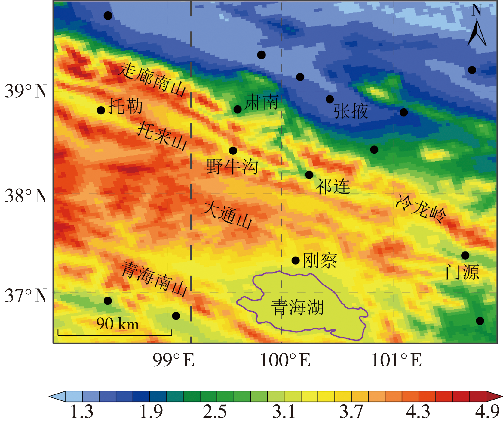
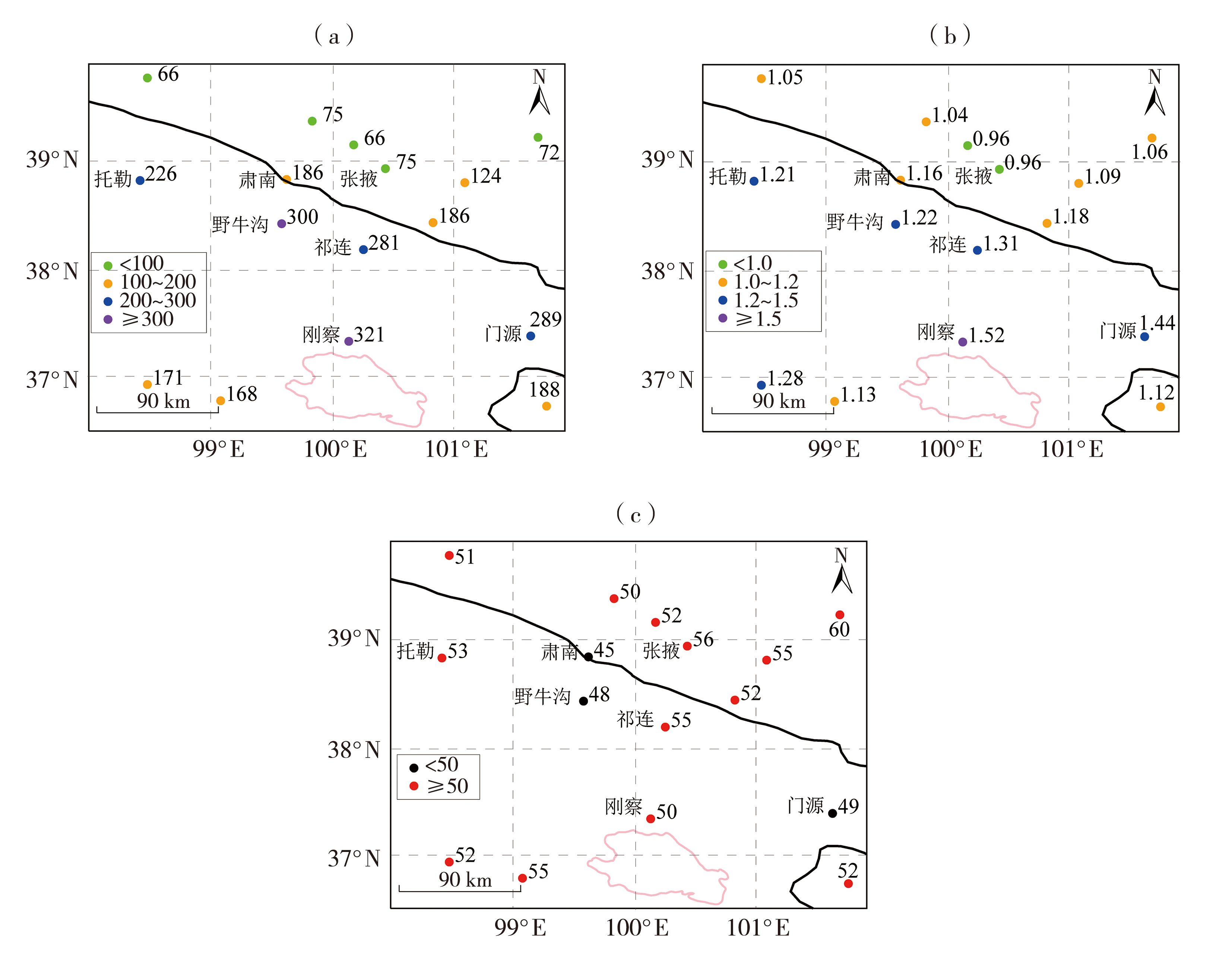
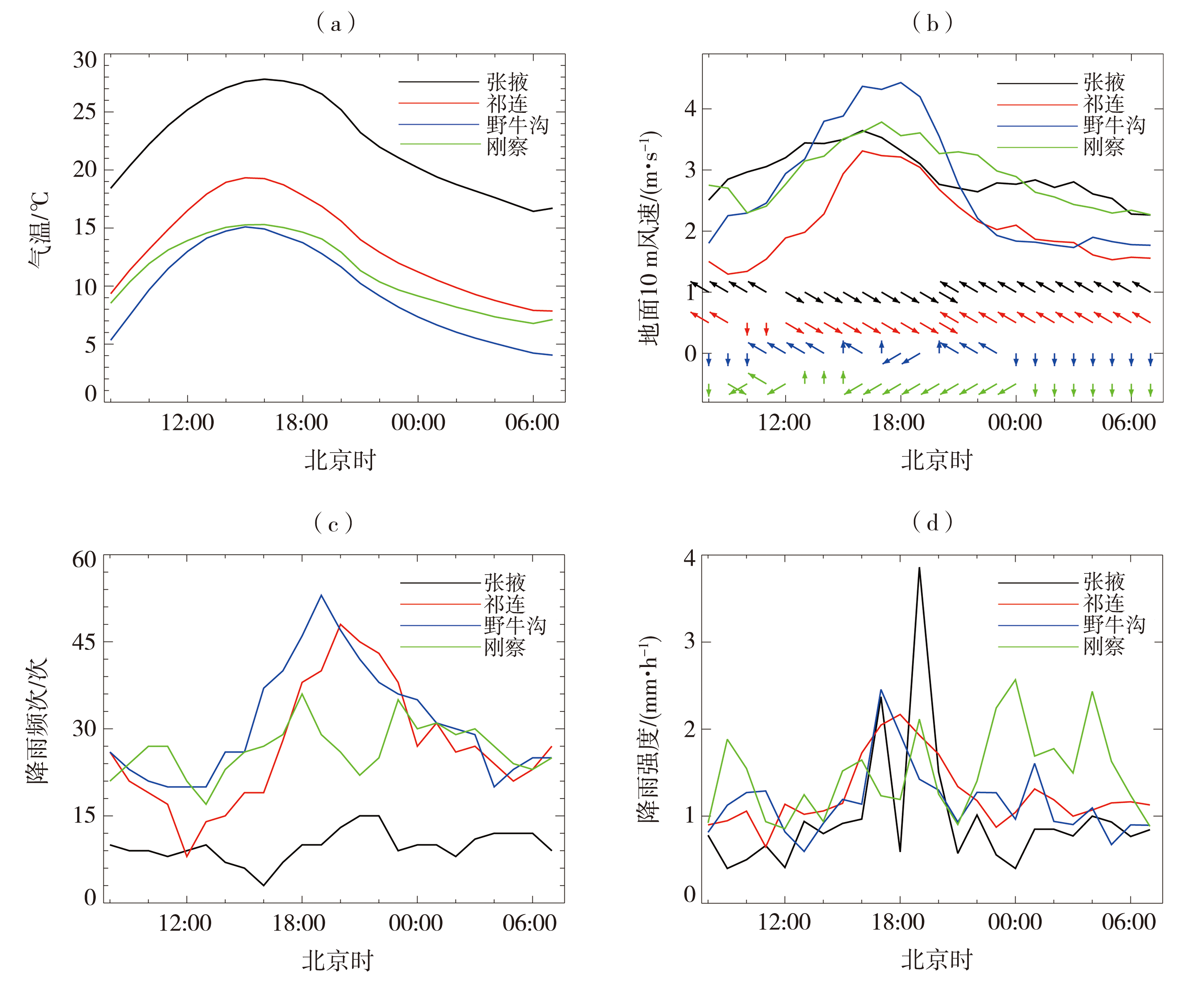
Characteristics of rainfall and convection in summer in the middle of the Qilian Mountains

DUAN Jing1(), WANG Xin2, CHEN Yong3, GUO Qiang2, WANG Tiantian1, CHEN Tianyu1, CHEN Baojun1   

  1. 1. CMA Key Laboratory of Cloud-Precipitation Physics and Weather Modification(CPML), Beijing 100081, China
    2. National Satellite Meteorological Centre (National Space Weather Monitoring and Early Warning Centre), Key Laboratory of Radiometric Calibration and Validation for Environmental Satellites, Innovation Centre for FengYun Meteorological Satellite (FYSIC), Beijing 100081, China
    3. Institute of Atmospheric Physics, Chinese Academy of Sciences, Beijing 100029, China
  • Received:2023-05-16 Revised:2023-08-06 Online:2024-06-30 Published:2024-07-11

祁连山中段夏季降雨与对流特征分析

段婧1(), 王新2, 陈勇3, 郭强2, 王田田1, 陈添宇1, 陈宝君1   

  1. 1.中国气象局云降水物理与人工影响天气重点开放实验室,北京 100081
    2.国家卫星气象中心(国家空间天气监测预警中心)/中国遥感卫星辐射测量和定标重点开放实验室/许健民气象卫星创新中心,北京 100081
    3.中国科学院大气物理研究所,北京 100029
  • 作者简介:段婧(1981—),女,河北石家庄人,研究员,主要从事云降水物理与人工影响天气、多源云降水探测资料融合应用研究。E-mail: duanjing@cma.gov.cn
  • 基金资助:
    第二次青藏高原综合科学考察研究项目(2019QZKK0105);中国气象局科技与气候变化司西北区域人影科学试验研究项目(RYSY201909);中国气象局重点创新团队(CMA2022ZD10)

Abstract:

The study of summer rainfall characteristics in the middle of the Qilian Mountains can provide weather background support for artificial precipitation enhancement by terrain clouds. Based on hourly surface meteorological observations and Temperature of Black Body (TBB) from FY-2G satellite during 2015-2017, the characteristics of rainfall and convection in summer and relationship between diurnal variation of rainfall and local circulation are investigated. The results show that the total rainfall amount of meteorological stations with an altitude less than 3.5 km in the middle of the Qilian Mountains increases linearly with the altitude, and in the eastern part (east of 99.2°E) it changes more sharply with the altitude than that in the western part. The diurnal variation of valley wind circulation and rainfall at Yeniugou and Qilian stations in the valley is more obvious than that at Gangcha Station near the Qinghai Lake. The maximum and sub-peak of rainfall at the two stations are in the evening and early morning, respectively, corresponding to the high frequency periods of the two main topographic clouds (cumulonimbus and stracumulus) in the region, and the average rainfall intensity is 2.0-2.3 and 1.0-1.3 mm·h-1, respectively. Compared with Zhangye Station in Hexi Corridor, the peak value of TBB probability distribution at Qilian, Yeniugou and Gangcha stations in the Qilian Mountains changed from -22--12 ℃ to -32--22 ℃ under two kinds of rainfall intensity (less than 1.5 and more than or equal to 1.5 mm·h-1). When the threshold of TBB <-32 ℃ is used to identify rainfall cloud, the coverage rate of rainfall cloud in the Qilian Mountains is lower than that in Hexi Corridor. The threshold of TBB <-22 ℃ is more suitable for the identification of weak convective rainfall clouds in the Qilian Mountains. In the study area, the high value areas of deep and shallow convection are distributed in the direction of north-south and northwest to southeast, respectively. The diurnal variation of shallow convective frequency based on TBB data can reflect some characteristics of diurnal variation of rainfall in this region.

Key words: the Qilian Mountains, orographic rain, FY-2G satellite, diurnal variation of rainfall, TBB

摘要:

祁连山中段夏季降雨特征研究可为地形云人工增雨提供天气背景依据支撑。基于2015—2017年地面观测资料和FY-2G卫星红外黑体亮度温度(Temperature of Black Body, TBB)逐时资料,分析祁连山中段夏季降雨与对流特征及降雨日变化与局地环流的关系。结果表明:祁连山中段海拔低于3.5 km的气象站降雨量随海拔呈线性递增变化,东部(99.2°E以东)降雨量随海拔的变化较西部剧烈。位于山谷的野牛沟和祁连站山谷风环流和降雨日变化较青海湖畔的刚察站明显,两站降雨最大值和次峰值分别在傍晚和清晨,分别对应该地区两类主要地形云(积雨云和层积云)高频时段,平均雨强分别为2.0~2.3、1.0~1.3 mm·h-1。与河西走廊张掖站相比,在雨强小于1.5 mm·h-1和大于等于1.5 mm·h-1条件下,祁连、野牛沟和刚察站的TBB概率分布峰值从-22~-12 ℃转为-32~-22 ℃;在使用TBB<-32 ℃的降雨云识别阈值时,祁连山地区降雨云的覆盖率低于河西走廊地区;TBB<-22 ℃阈值更适宜祁连山地区弱对流降雨云的识别。研究区内深对流与浅对流的高值区分别呈现南北向、西北—东南向分布,基于TBB资料的浅对流频率日变化等可反映该地区降雨日变化的部分特征。

关键词: 祁连山, 地形云降雨, FY-2G卫星, 降雨日变化, 黑体亮度温度

CLC Number: