Journal of Arid Meteorology ›› 2022, Vol. 40 ›› Issue (6): 1003-1013.DOI: 10.11755/j.issn.1006-7639(2022)-06-1003
• Articles • Previous Articles Next Articles
Study on cloud structure and rainfall enhancement condition of a low-trough cold-front cloud over North China
SHI Yueqin1,2( ), ZHAO Junjie3, SUN Jing1,2, SUN Yuwen4()
- 1. CMA Cloud-Precipitation Physics and Weather Modification Key Laboratory, Beijing 100081, China
2. Weather Modification Center of China Meteorological Administration, Beijing 100081, China
3. Meteorological Disasters Defense Technology Center of Shanxi Province, Taiyuan 030032, China
4. Hebei Provincial Weather Modification Office, Shijiazhuang 050021, China
-
Received:2022-02-05Revised:2022-08-14Online:2022-12-31Published:2023-01-10 -
Contact:SUN Yuwen
华北地区一次低槽冷锋云系结构和增雨条件研究
- 1.中国气象局云降水物理与人工影响天气重点开放实验室,北京 100081
2.中国气象局人工影响天气中心,北京 100081
3.山西省气象灾害防御技术中心,山西 太原 030032
4.河北省人工影响天气办公室,河北 石家庄 050021
-
通讯作者:孙玉稳 -
作者简介:史月琴(1973—),女,山西平遥人,博士,正研级高级工程师,主要从事云降水物理与人工影响天气研究. E-mail: shiyq@cma.gov.cn。 -
基金资助:国家重点研发计划课题“新一代人影数值模式系统研发”(2018YFC1507901);河北省“十三五”气象重点项目——云水资源开发利用工程的示范项目“太行山东麓人工增雨防雹作业技术试验”(HBRYWCSY-2017);西北区域人工影响天气能力建设项目研究试验“西北区域中尺度人影模式同化系统研制和应用”(RYSY201908)
CLC Number:
Cite this article
SHI Yueqin, ZHAO Junjie, SUN Jing, SUN Yuwen. Study on cloud structure and rainfall enhancement condition of a low-trough cold-front cloud over North China[J]. Journal of Arid Meteorology, 2022, 40(6): 1003-1013.
史月琴, 赵俊杰, 孙晶, 孙玉稳. 华北地区一次低槽冷锋云系结构和增雨条件研究[J]. 干旱气象, 2022, 40(6): 1003-1013.
share this article
Add to citation manager EndNote|Ris|BibTeX
URL: http://www.ghqx.org.cn/EN/10.11755/j.issn.1006-7639(2022)-06-1003

Fig.1 The distribution of geopotential height, temperature, wind field, black body temperature observed by satellite FY-2F and specific humidity at 08:00 BST (a, b) and 20:00 BST (c, d) May 22, 2017(In fig. a and fig. c, the red dashed isolines are temperature (Unit: ℃) at 500 hPa, the blue and black solid contours are geopotential height (Unit: dagpm) at 500 hPa and 700 hPa, respectively, wind vectors (Unit: m·s-1) are wind field at 700 hPa, the color shaded is black body temperature of FY-2F (Unit: K). In fig. b and fig. d, the purple solid contours are geopotential height (Unit: dagpm) at 850 hPa, the color shaded is specific humidity (Unit: g·kg-1) , and wind vectors are wind field at 10 m height (Unit: m·s-1))
Fig.1 The distribution of geopotential height, temperature, wind field, black body temperature observed by satellite FY-2F and specific humidity at 08:00 BST (a, b) and 20:00 BST (c, d) May 22, 2017(In fig. a and fig. c, the red dashed isolines are temperature (Unit: ℃) at 500 hPa, the blue and black solid contours are geopotential height (Unit: dagpm) at 500 hPa and 700 hPa, respectively, wind vectors (Unit: m·s-1) are wind field at 700 hPa, the color shaded is black body temperature of FY-2F (Unit: K). In fig. b and fig. d, the purple solid contours are geopotential height (Unit: dagpm) at 850 hPa, the color shaded is specific humidity (Unit: g·kg-1) , and wind vectors are wind field at 10 m height (Unit: m·s-1))

Fig.2 The distribution of observed (the left) and simulated (the right) 3 h rainfall on May 22, 2017 (Unit: mm) (The black dot is Xingtai station)
Fig.2 The distribution of observed (the left) and simulated (the right) 3 h rainfall on May 22, 2017 (Unit: mm) (The black dot is Xingtai station)
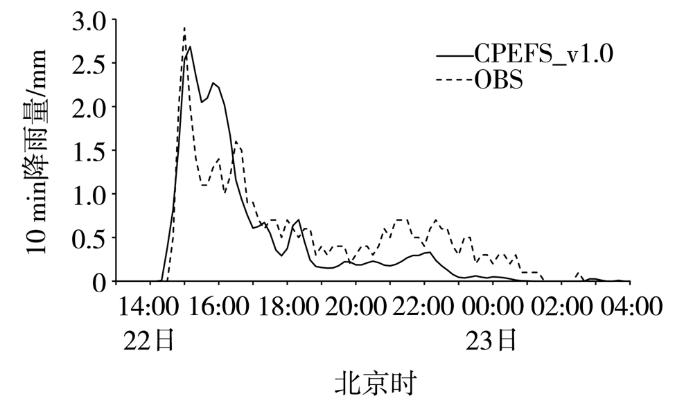
Fig.3 The evolution of observed and simulated 10-minute rainfall from 13:00 BST 22 to 04:00 BST 23 May, 2017 at Xingtai station
Fig.3 The evolution of observed and simulated 10-minute rainfall from 13:00 BST 22 to 04:00 BST 23 May, 2017 at Xingtai station
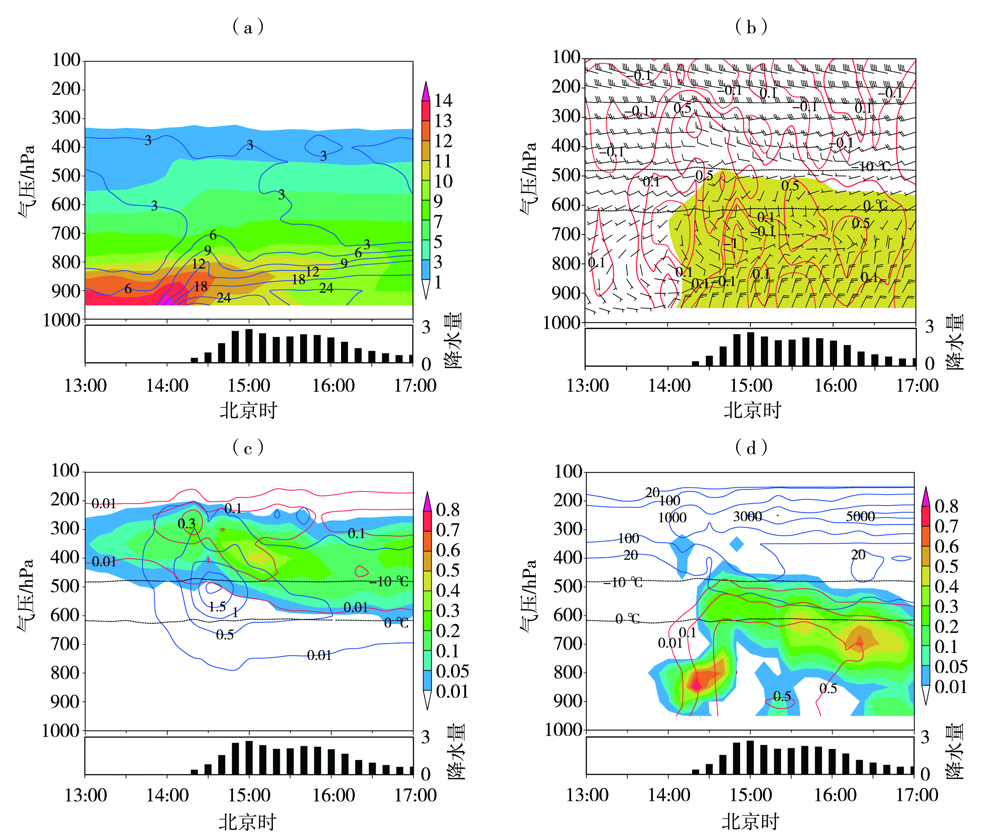
Fig.4 Time-height cross sections of physical quantities from 13:00 BST to 17:00 BST May 22, 2017 at Xingtai station (The black thick bar at bottom is 10 min rainfall, Unit: mm)(a) specific humidity (the color shaded, Unit: g·kg-1) and water vapor flux (blue isolines, Unit: g·hPa-1·cm-1·s-1), (b) horizontal wind (wind vectors, Unit: m·s-1) and vertical velocity (red isolines, Unit: m·s-1) (the yellow shaded for the mixing ratio of rain water greater than 0.01 g·kg-1), (c) mixing ratio of ice crystal (red isolines), snow (the color shaded) and graupel(blue isolines) (Unit: g·kg-1), (d) mixing ratio of cloud water (the color shaded), rain water (red isolines)(Unit: g·kg-1) and number concentration of ice crystal (blue isolines, Unit: L-1)
Fig.4 Time-height cross sections of physical quantities from 13:00 BST to 17:00 BST May 22, 2017 at Xingtai station (The black thick bar at bottom is 10 min rainfall, Unit: mm)(a) specific humidity (the color shaded, Unit: g·kg-1) and water vapor flux (blue isolines, Unit: g·hPa-1·cm-1·s-1), (b) horizontal wind (wind vectors, Unit: m·s-1) and vertical velocity (red isolines, Unit: m·s-1) (the yellow shaded for the mixing ratio of rain water greater than 0.01 g·kg-1), (c) mixing ratio of ice crystal (red isolines), snow (the color shaded) and graupel(blue isolines) (Unit: g·kg-1), (d) mixing ratio of cloud water (the color shaded), rain water (red isolines)(Unit: g·kg-1) and number concentration of ice crystal (blue isolines, Unit: L-1)
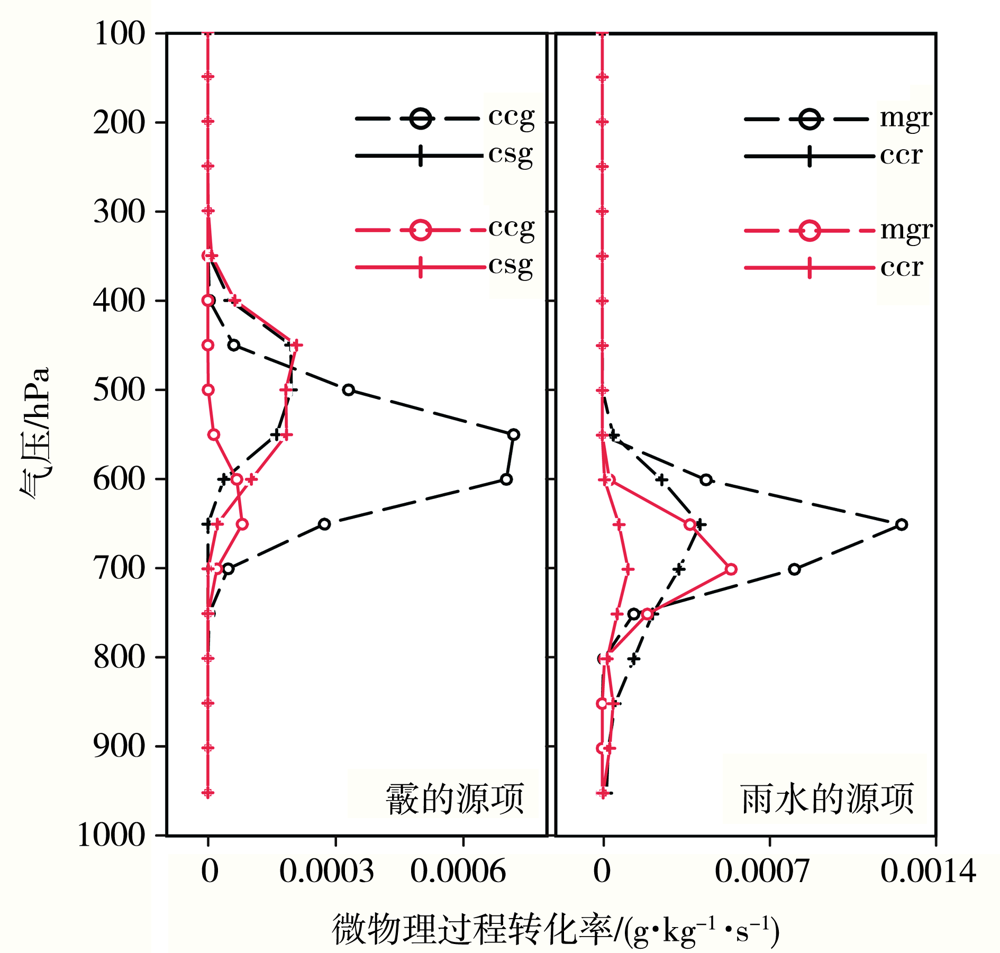
Fig.5 Mean profiles of microphysical process conversion rates at Xingtai station (the black lines averaged from 13:00 BST to 17:00 BST May 22,the red lines averaged from 17:10 BST May 22 to 01:20 BST May 23)
Fig.5 Mean profiles of microphysical process conversion rates at Xingtai station (the black lines averaged from 13:00 BST to 17:00 BST May 22,the red lines averaged from 17:10 BST May 22 to 01:20 BST May 23)
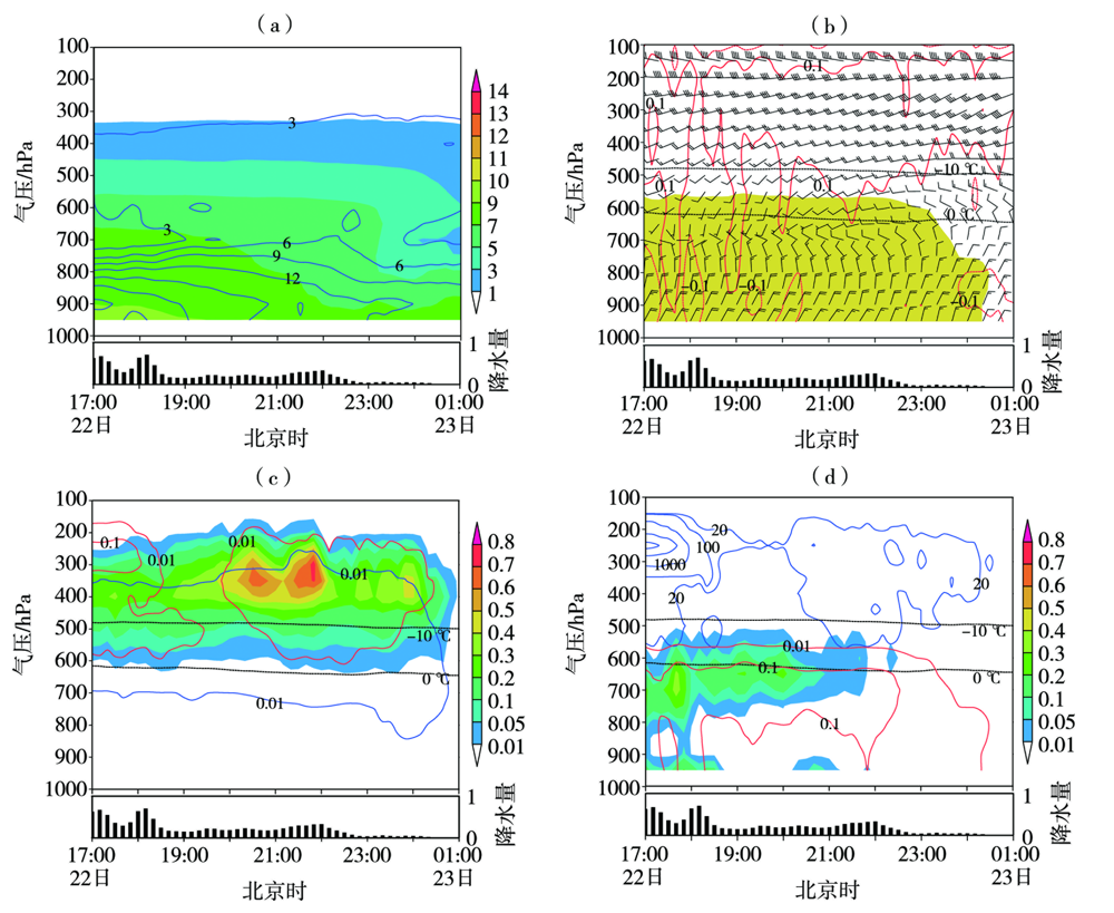
Fig.6 Time-height cross sections of physical quantities from 17:00 BST May 22 to 01:00 BST May 23 at Xingtai station (The black thick bar at bottom is 10 min rainfall, Unit: mm) (a) specific humidity (the color shaded, Unit: g·kg-1) and water vapor flux (blue isolines, Unit: g·hPa-1·cm-1·s-1), (b) horizontal wind (wind vectors, Unit: m·s-1) and vertical velocity (red isolines, Unit: m·s-1) (the yellow shaded for the mixing ratio of rain water greater than 0.01 g·kg-1), (c) mixing ratio of ice crystal (red isolines), snow (the color shaded) and graupel (blue isolines) (Unit: g·kg-1), (d) mixing ratio of cloud water (the color shaded), rain water(red isolines) (Unit: g·kg-1) and number concentration of ice crystal (blue isolines, Unit: L-1)
Fig.6 Time-height cross sections of physical quantities from 17:00 BST May 22 to 01:00 BST May 23 at Xingtai station (The black thick bar at bottom is 10 min rainfall, Unit: mm) (a) specific humidity (the color shaded, Unit: g·kg-1) and water vapor flux (blue isolines, Unit: g·hPa-1·cm-1·s-1), (b) horizontal wind (wind vectors, Unit: m·s-1) and vertical velocity (red isolines, Unit: m·s-1) (the yellow shaded for the mixing ratio of rain water greater than 0.01 g·kg-1), (c) mixing ratio of ice crystal (red isolines), snow (the color shaded) and graupel (blue isolines) (Unit: g·kg-1), (d) mixing ratio of cloud water (the color shaded), rain water(red isolines) (Unit: g·kg-1) and number concentration of ice crystal (blue isolines, Unit: L-1)

Fig.7 Variation of physical quantities and the identified glaciogenic seeding areas during the frontal uplifting heavy rain period from 13:00 BST to 17:00 BST 22 May 2017 (a) and the deep stratus cloud light rain period from 17:00 BST 22 to 01:00 BST 23 May 2017 (b) at Xingtai station
Fig.7 Variation of physical quantities and the identified glaciogenic seeding areas during the frontal uplifting heavy rain period from 13:00 BST to 17:00 BST 22 May 2017 (a) and the deep stratus cloud light rain period from 17:00 BST 22 to 01:00 BST 23 May 2017 (b) at Xingtai station
| [1] | 王江涛. 基于华北地区气象指数SPI干旱时空分析[J]. 水土保持研究, 2019, 26(4): 203-207. |
| [2] | 段英, 吴志会, 石立新. 飞机人工增雨催化条件的研究[J]. 生态农业研究, 1998, 6(1): 80-83. |
| [3] |
HOBBS P V, MATEJKA T J, HERZEGH P H, et al. The mesoscale and microscale structure and organization of clouds and precipitation in mid-latitude cyclones. I: a case study of a cold front[J]. Journal of Atmospheric Sciences, 1980, 37 (3): 568-596.
DOI URL |
| [4] | 洪延超, 李宏宇. 一次锋面层状云云系结构、降水机制及人工增雨条件研究[J]. 高原气象, 2011, 30(5):1308-1323. |
| [5] | 彭冲. 两类层状云系结构特征和人工增雨条件的观测研究[D]. 南京: 南京信息工程大学, 2014. |
| [6] | 刘涛, 孙晶, 周毓荃, 等. 一次低槽冷锋层状云系结构和过冷水分布特征的模拟研究[J]. 气象, 2015, 41(10): 1232-1244. |
| [7] |
孙晶, 杨文霞, 周毓荃. 河北一次降水层状云系结构和增雨条件的模拟研究[J]. 高原气象, 2015, 34(6): 1699-1710.
DOI |
| [8] | 居丽玲. 河北省春秋季层状降水云系宏微观结构观测和数值模拟研究[D]. 南京: 南京信息工程大学, 2012. |
| [9] | 胡志晋. 层状云人工增雨机制、条件和方法的探讨[J]. 应用气象学报, 2001, 12(增刊): 10-13. |
| [10] | 陶树旺, 刘卫国, 李念童, 等. 层状冷云人工增雨可播性实时识别技术研究[J]. 应用气象学报, 2001, 12(增刊): 14-22. |
| [11] | 何晖, 高茜, 李宏宇. 北京层状云人工增雨数值模拟试验和机理研究[J]. 大气科学, 2013, 37(4): 905-922. |
| [12] |
XUE L L, TESSENDORF S A, NELSON E, et al. Implementation of a silver iodide cloud-seeding parameterization in WRF. Part II: 3D simulations of actual seeding events and sensitivity tests[J]. Journal of Applied Meteorology and Climatology, 2013, 52(6): 1458-1476.
DOI URL |
| [13] | 刘卫国, 陶玥, 周毓荃. 层状云催化宏微观物理响应的数值模拟研究[J]. 大气科学, 2021, 45(1): 37-57. |
| [14] |
DeMOTT P J. Quantitative descriptions of ice formation mechanisms of silver iodide-type aerosols[J]. Atmospheric Research, 1995, 38(1): 63-99.
DOI URL |
| [15] | MEYERS M P, DeMOTT P J, COTTON W R. A comparison of seeded and nonseeded orographic cloud simulations with an explicit cloud model[J]. Journal of Applied Meteorology and Climatology, 1995, 34(4): 834-846. |
| [16] | 潘旸, 沈艳, 宇婧婧, 等. 基于最优插值方法分析的中国区域地面观测与卫星反演小时降水融合试验[J]. 气象学报, 2012, 70(6):1381-1389. |
| [17] |
LOU X F, SHI Y Q, SUN J, et al. Cloud-resolving model for weather modification in China[J]. Chinese Science Bulletin, 2012, 57(9): 1055-1061.
DOI URL |
| [18] | 刘卫国, 陶玥, 党娟, 等. 2014年春季华北两次降水过程的人工增雨催化数值模拟研究[J]. 大气科学, 2016, 40 (4): 669-688. |
| [19] | 江燕茹, 王丽娟, 钱代丽, 等. 典型天气过程分析[M]. 北京: 气象出版社, 2016. |
| [20] | 国家气象中心. 降水量等级: GB/T 28592—2012[S]. 北京: 中国标准出版社, 2012. |
| [21] |
RUTLEDGE S A, HOBBS P V. The mesoscale and microscale structure and organization of clouds and precipitation in mid-latitude cyclones. XII: a diagnostic modeling study of precipitation development[J]. Journal of Atmospheric Sciences, 1984, 41(20): 2949-2972.
DOI URL |
| [1] | MA Minjin, CHEN Yue, KANG Guoqiang, ZHAO Zhenzhu, HUANG Wanlong, TAN Changrong, DING Fan. Deviation analysis of reanalysis data in boundary layer in summer over Tibetan Plateau and its simulation correction [J]. Journal of Arid Meteorology, 2022, 40(1): 95-107. |
| [2] | REN Yulong, ZHANG Tiejun, LIU Yuanpu, WU Jing. Numerical Simulation of Influence of Underlying Surface Heterogeneity on a Rainstorm Process in Summer Monsoon Transition Zone of China [J]. Journal of Arid Meteorology, 2020, 38(5): 755-763. |
| [3] | QI Yajie, CHEN Min, ZHONG Jiqin, FAN Shuiyong, LIU Ruiting, GUO Chunwei. Effect Evaluation of Short-term Forecast of Surface Meteorological Elements by Using RMAPS-ST Coupled Urban Canopy Model in North China [J]. Journal of Arid Meteorology, 2020, 38(5): 859-868. |
| [4] | YANG Kan JI Xiaoling, MAO Lu, ZHANG Suzhao. Numerical Simulation and Comparative Analysis of Topographic Effects on Two Extraordinary Severe Flood Rainstorms in Helan Mountain [J]. Journal of Arid Meteorology, 2020, 38(4): 581-590. |
| [5] | ZENG Yong, YANG Lianmei, ZHANG Yingxin. Numerical Simulation of Mesoscale System During a Rare Torrential Rainstorm Process in Yili of Xinjiang [J]. Journal of Arid Meteorology, 2020, 38(2): 290-300. |
| [6] | TANG Lin, LI Qiong, LI Zuxian, CAI Miao, CAI Ronghui, GAO Qin. Numerical Simulation of Mircophysical Structure of a Mixed Convective Stratiform Cloud System and Analysis of Seeding Conditions#br# [J]. Journal of Arid Meteorology, 2020, 38(1): 100-108. |
| [7] | ZHAO Cailing1,2, ZHANG Tiejun1, WANG Wei1, LIU Yuanpu1, ZENG Dingwen1, LI Yaohui1. Impacts of Land-use Data on the Simulation of 10 m Wind Speed in Northwest China [J]. Journal of Arid Meteorology, 2018, 36(3): 397-. |
| [8] | REN Yulong, LI Yaohui, DUAN Haixia, SONG Linlin. Numerical Simulation of an Extreme Drought Event and Its Wave-Flow Action Analysis in Spring of 1995 in Northwest China [J]. Journal of Arid Meteorology, 2017, 35(4): 535-544. |
| [9] | . Evolution Characteristics of Two Southwest Vortex Clouds Moving Eastward in Spring [J]. Journal of Arid Meteorology, 2017, 35(3): 456-. |
| [10] | . Numerical Simulation of a Hailstorm Process and AgI-seeding in Xichang of Sichuan Province [J]. Journal of Arid Meteorology, 2017, 35(3): 490-. |
| [11] | SUN Jing1,2, SHI Yueqin1,2, CAI Zhaoxin3, CAI Miao1,2, ZHOU Yuquan1,2. Verification of Cloud Structure and Precipitation Forecast of a Vortex Cyclone [J]. Journal of Arid Meteorology, 2017, 35(2): 275-290. |
| [12] | XU Hong, CHENG Pan, WANG Ruili. Simulation and Diagnostic Analysis of a Rainstorm Process Influenced by Typhoon Haiyan (2013) on Hainan Island [J]. Journal of Arid Meteorology, 2016, 34(3): 503-510. |
| [13] | MA Yanzhi, ZHAO Guixiang, HAO Jingyu,YAN Hui, ZHANG Lei. Numerical Simulation and Diagnostic Analysis About a Heavy Rainstorm Process in North China Based on WRF Model [J]. Journal of Arid Meteorology, 2016, 34(3): 511-521. |
| [14] | CAO Qian, YANG Xixi,YE Dan, ZHANG Shuwen. Analysis of Doppler Radar Observation and Simulation on a Squall Line Process on 26 July 2011 in Hubei Province [J]. Journal of Arid Meteorology, 2016, 34(2): 305-316. |
| [15] | BIAN Shuangshuang,HE Hongrang,ZHANG Yun,MIAO Ziqing,BAI Shigang,XIE Fei. Effect Evaluation of Parameterization Schemes in Numerical Simulation Test About Aircraft Icing Situation Field [J]. Journal of Arid Meteorology, 2016, 34(1): 106-112. |
| Viewed | ||||||
|
Full text |
|
|||||
|
Abstract |
|
|||||