干旱气象 ›› 2023, Vol. 41 ›› Issue (6): 997-1007.DOI: 10.11755/j.issn.1006-7639(2023)-06-0997
• 技术报告 • 上一篇
卫星降水产品在陇东2022年7月特大暴雨事件中的适用性评估
- 1.兰州中心气象台,甘肃 兰州 730020
2.甘肃省高台县气象局,甘肃 高台 734300
-
收稿日期:2022-08-23修回日期:2023-09-14出版日期:2023-12-31发布日期:2024-01-03 -
通讯作者:刘维成(1984—),男,正高级工程师,主要从事强对流天气监测预警和数值预报等研究。E-mail:cnliuwc@163.com 。 -
作者简介:王一丞(1993—),男,工程师,主要从事客观预报技术研究等。E-mail:wangyc_climate@163.com。 -
基金资助:中国气象局气象能力提升联合研究专项(23NLTSZ001);甘肃省气象局气象科研重点项目(Zd2023-03);与甘肃省气象局气象科研项目人才专项(2122rczx-十人计划-01)
Applicability evaluation of satellite-derived precipitation products in the torrential heavy rainfall event in East Gansu in July 2022
WANG Yicheng1( ), LIU Weicheng1(), SONG Xingyu1, ZHANG Wenguang2
- 1. Lanzhou Central Meteorological Observatory, Lanzhou 730020, China
2. Gaotai County Meteorological Bureau of Gansu Province, Gaotai 734300, Gansu, China
-
Received:2022-08-23Revised:2023-09-14Online:2023-12-31Published:2024-01-03
摘要:
以地面雨量站观测数据、中国气象局多源融合降水数据(CMPAS)为基准,通过定量、分类、结构相似度3种方法综合评估8种卫星降水产品(FY-4A、CMOPRH-RT、IMERG-Early、IMERG-Late、GSMaP-Now、GSMaP-Gauge、PERSIANN-Now、PERSIANN-CCS)在甘肃陇东2022年7月一次破历史记录的极端性强降水过程中的适用性。结果表明:(1)8种卫星降水产品基本反映降水中东部大、西北小的空间分布特征,除GSMaP-Now产品外,其余7种产品均低估暴雨中心降水量。(2)8种卫星降水估算产品对于强降水峰值的描述能力较好,强降水过程的2个峰值阶段均有体现,但均严重低估大暴雨及以上量级降水。(3)GSMaP-Gauge对暴雨以下量级降水估算最优,而CMOPRH-RT对暴雨及以上量级降水估算最优,所有产品对特大暴雨量级降水均无法正确命中。(4)CMOPRH-RT产品能从降水总量、降水量级、形态分布三方面最好地表现降水过程的结构分布。对本次降水事件,CMOPRH-RT降水产品在各方面表现综合最优。
中图分类号:
引用本文
王一丞, 刘维成, 宋兴宇, 张文光. 卫星降水产品在陇东2022年7月特大暴雨事件中的适用性评估[J]. 干旱气象, 2023, 41(6): 997-1007.
WANG Yicheng, LIU Weicheng, SONG Xingyu, ZHANG Wenguang. Applicability evaluation of satellite-derived precipitation products in the torrential heavy rainfall event in East Gansu in July 2022[J]. Journal of Arid Meteorology, 2023, 41(6): 997-1007.
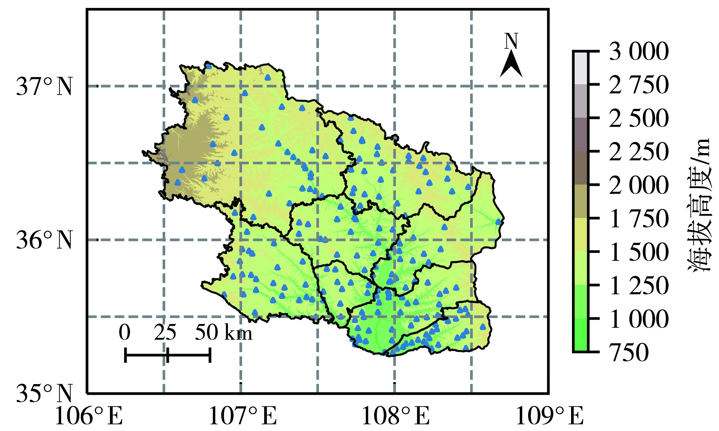
图1 研究区及雨量站位置分布
Fig.1 The study area and distribution of ground rainfall stations
图1 研究区及雨量站位置分布
Fig.1 The study area and distribution of ground rainfall stations
表1 卫星降水产品的基本信息
Tab.1 Basic information of 8 kinds of satellite-based precipitation products
| 降水产品 | 时间 分辨率 | 空间 分辨率 | 主要算法 | 主要数据源 |
|---|---|---|---|---|
| FY-4A(Li et al., | 1 h | 4 km | 建立红外亮温观测数据与降水率的关系 | FY-4A卫星 |
| CMOPRH-RT(Joyce et al., | 30 min | 8 km | 微波反演降水,红外获取云系的运动矢量 | TMI、SSM/I、AMSU-B、AMSR-E、GEO系列卫星 |
| IMERG-Early(Hou et al., | 30 min | 0.1° | 微波反演降水,红外反演降水及获取 运动信息 | GMI、DPR、SSM/I、SSMIS、AMSR-E、AMSR2、AMSU-B、MHS、ATMS、GEO系列卫星 |
| IMERG-Late(Hou et al., | 30 min | 0.1° | ||
| GSMaP-Now (Kubota et al., | 30 min | 0.1° | 微波反演降水,红外获取云系的运动矢量 | GMI、AMSR2、AMSU、SSMIS、GEO系列卫星 |
| GSMaP-Gauge (Kubota et al., | 1 h | 0.1° | ||
| PERSIANN-Now (Nguyen et al., | 1 h | 0.04° | 建立红外亮温观测数据与降水率的 关系,气候降水曲线订正 | GEO系列卫星 |
| PERSIANN-CCS (Nguyen et al., | 1 h | 0.04° | 建立不同种类云的云顶红外亮温与 降水之间的关系 |
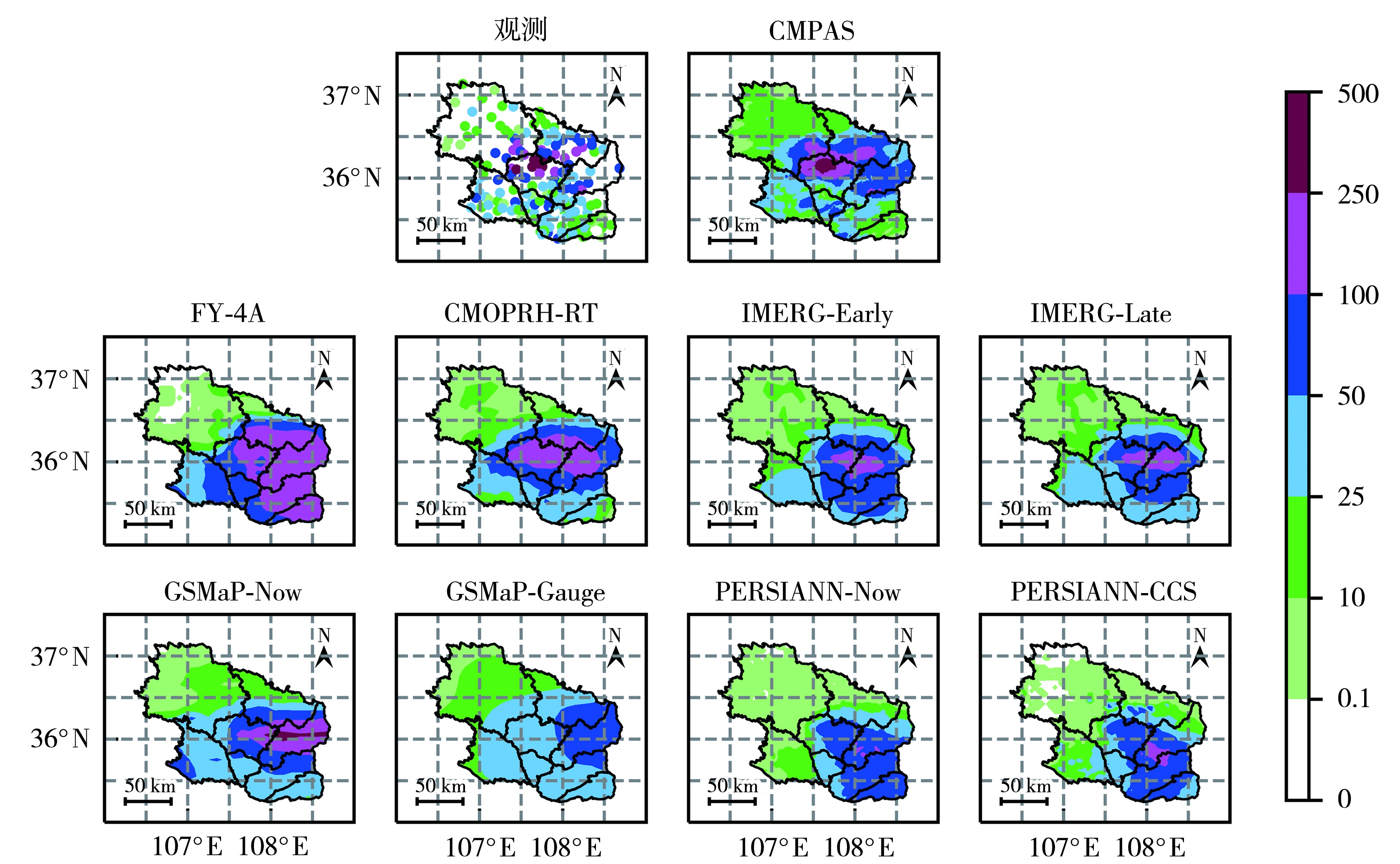
图2 2022年7月14日20:00至15日20:00观测、CMPAS与8种卫星降水产品累积降水空间分布(单位:mm)
Fig.2 Spatial distribution of cumulative precipitation from 20:00 July 14 to 20:00 July 15, 2022 observed and from CMPAS as well as 8 kinds of satellite-based precipitation products
图2 2022年7月14日20:00至15日20:00观测、CMPAS与8种卫星降水产品累积降水空间分布(单位:mm)
Fig.2 Spatial distribution of cumulative precipitation from 20:00 July 14 to 20:00 July 15, 2022 observed and from CMPAS as well as 8 kinds of satellite-based precipitation products

图3 2022年7月14日20:00至15日20:00观测与各卫星降水产品累积降水量对比
Fig.3 Comparison of cumulative precipitation from 20:00 July 14 to 20:00 July 15, 2022 observed and 8 kinds of satellite-based precipitation products
图3 2022年7月14日20:00至15日20:00观测与各卫星降水产品累积降水量对比
Fig.3 Comparison of cumulative precipitation from 20:00 July 14 to 20:00 July 15, 2022 observed and 8 kinds of satellite-based precipitation products
表2 总降水结构相似度
Tab.2 The structure similarity of total precipitation
| 降水产品 | SSIM | SIM | SIV | SIP |
|---|---|---|---|---|
| FY-4A | 0.370 | 0.896 | 0.939 | 0.439 |
| CMOPRH-RT | 0.727 | 1.000 | 0.990 | 0.735 |
| IMERG-Early | 0.371 | 0.982 | 0.930 | 0.406 |
| IMERG-Late | 0.427 | 0.973 | 0.916 | 0.479 |
| GSMaP-Now | 0.364 | 0.991 | 0.985 | 0.373 |
| GSMaP-Gauge | 0.331 | 0.961 | 0.672 | 0.512 |
| PERSIANN-Now | 0.259 | 0.902 | 0.929 | 0.309 |
| PERSIANN-CCS | 0.295 | 0.909 | 0.916 | 0.354 |
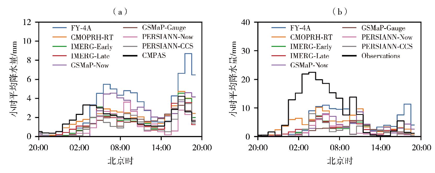
图4 2022年7月14日20:00至15日20:00 8种降水产品(a)与大暴雨及以上量级降水站点(b)的小时平均降水量时间序列
Fig.4 Hourly average precipitation time series of 8 kinds of precipitation products (a) and at stations with heavy rainstorms and above (b) from 20:00 July 14 to 20:00 July 15, 2022
图4 2022年7月14日20:00至15日20:00 8种降水产品(a)与大暴雨及以上量级降水站点(b)的小时平均降水量时间序列
Fig.4 Hourly average precipitation time series of 8 kinds of precipitation products (a) and at stations with heavy rainstorms and above (b) from 20:00 July 14 to 20:00 July 15, 2022
表3 8种降水产品逐小时平均降水量精度指标
Tab.3 Hourly average precipitation accuracy index of 8 kinds of precipitation products
| 降水产品 | RB/% | CC | |||
|---|---|---|---|---|---|
| 区域内 平均 | 大暴雨及以上站点平均 | 区域内平均 | 大暴雨及以上站点平均 | ||
| FY-4A | 56.7 | -39.7 | 0.89 | 0.61 | |
| CMOPRH-RT | 0.01 | -46.7 | 0.99 | 0.82 | |
| IMERG-Early | -19.8 | -71.2 | 0.94 | 0.79 | |
| IMERG-Late | -23.4 | -70.0 | 0.94 | 0.84 | |
| GSMaP-Now | 11.0 | -63.6 | 0.77 | 0.39 | |
| GSMaP-Gauge | -27.0 | -76.7 | 0.87 | 0.62 | |
| PERSIANN-Now | -39.0 | -79.9 | 0.71 | 0.50 | |
| PERSIANN-CCS | -37.9 | -77.5 | 0.84 | 0.70 | |

图5 8种降水产品不同降水等级下的POD(a)、FAR(b)和CSI(c)评分
Fig.5 The POD (a), FAR (b) and CSI (c) scores of 8 kinds of precipitation products under different rainfall levels
图5 8种降水产品不同降水等级下的POD(a)、FAR(b)和CSI(c)评分
Fig.5 The POD (a), FAR (b) and CSI (c) scores of 8 kinds of precipitation products under different rainfall levels
| [1] | 柏荷, 明義森, 刘启航, 等, 2022. 基于GPM卫星降雨产品的2001—2019年中国暴雨数据集[J]. 中国科学数据, 7(2): 227-236. |
| [2] | 曾岁康, 雍斌, 2019. 全球降水计划IMERG和GSMaP反演降水在四川地区的精度评估[J]. 地理学报, 74(7): 1 305-1 318. |
| [3] | 陈晓宏, 钟睿达, 王兆礼, 等, 2017. 新一代GPM IMERG卫星遥感降水数据在中国南方地区的精度及水文效用评估[J]. 水利学报, 48(10): 1 147-1 156. |
| [4] | 丁明泽, 雍斌, 杨泽康, 2022. 全球降水观测计划多卫星联合反演降水产品的极端降水监测潜力研究[J]. 遥感学报, 26(4): 657-671. |
| [5] | 郭广芬, 杜良敏, 肖莺, 等, 2021. 长江流域夏季极端降水时空分布特征[J]. 干旱气象, 39 (2): 235-243. |
| [6] | 胡庆芳, 张野, 李伶杰, 等, 2022. GPM近实时反演数据对河南省2021年“7·20”极端暴雨的比较分析[J]. 水科学进展, 33(4): 567-580. |
| [7] |
黄楚惠, 牛金龙, 李国平, 等, 2022. 基于西南区域中尺度模式系统预报的陡峭地形过渡带降水订正方法[J]. 干旱气象, 40(2): 317-326.
DOI |
| [8] | 黄嘉佑, 2010. 气象统计分析与预报方法[M]. 北京: 气象出版社: 3-18. |
| [9] | 井宇, 陈闯, 王建鹏, 等, 2020. 一次大暴雨过程中两个强降水时段差异对比[J]. 干旱气象, 38(1): 126-136. |
| [10] |
李伶杰, 胡庆芳, 黄勇, 等, 2018. 近实时卫星降水数据对南京“20170610”极端性强降水过程的监测分析[J]. 高原气象, 37(3): 806-814.
DOI |
| [11] | 廖荣伟, 张冬斌, 沈艳, 2015. 6种卫星降水产品在中国区域的精度特征评估[J]. 气象, 41(8): 970-979. |
| [12] | 刘俊峰, 陈仁升, 韩春坛, 等, 2010. 多卫星遥感降水数据精度评价[J]. 水科学进展, 21(3): 343-348. |
| [13] | 刘少军, 蔡大鑫, 韩静, 等, 2021. 卫星遥感反演降水研究进展简述[J]. 气象科技进展, 11(1): 28-33. |
| [14] | 柳龙生, 许映龙, 2020. 孟加拉湾风暴"罗纳"对我国华南地区强降水的影响[J]. 干旱气象, 38(2): 271-279. |
| [15] | 龙柯吉, 谷军霞, 师春香, 等, 2020. 多种降水实况融合产品在四川一次强降水过程中的评估[J]. 高原山地气象研究, 40(2): 31-37. |
| [16] | 马艳, 郭丽娜, 2020. 气候变化和城市化对青岛降水的影响[J]. 干旱气象, 38(6): 920-928. |
| [17] |
毛程燕, 马依依, 孙杭媛, 等, 2022. 不同路径移出型西南涡对中国中东部降水的影响[J]. 干旱气象, 40(3): 386-395.
DOI |
| [18] | 孙乐强, 郝振纯, 王加虎, 2014. TMPA卫星降水数据的评估与校正[J]. 水利学报, (10): 1 135-1 146. |
| [19] | 孙帅, 师春香, 潘旸, 等, 2020. 中国区域三源融合降水产品的改进效果评估[J]. 水文, 40(6): 10-15. |
| [20] |
沙宏娥, 傅朝, 刘维成, 等, 2022. 西北东部半干旱区一次极端特大暴雨的触发和维持机制[J]. 干旱气象, 40(6): 933-944.
DOI |
| [21] | 许时光, 牛铮, 沈艳, 等, 2014. CMORPH卫星降水数据在中国区域的误差特征研究[J]. 遥感技术与应用, 29(2): 189-194. |
| [22] |
杨文月, 马金辉, 杨文凯, 2014. 基于TRMM卫星的近10a甘肃临夏降水变化特征[J]. 干旱气象, 32(6): 934-939.
DOI |
| [23] | 张华龙, 肖柳斯, 陈生, 等, 2020. 基于GPM卫星的广东汛期降水日变化特征与评估[J]. 热带气象学报, 36(3): 335-346. |
| [24] |
张君霞, 黄武斌, 杨秀梅, 等, 2022. 陇东半干旱区一次特大暴雨事件的降水极端性分析[J]. 干旱气象, 40(6): 922-932.
DOI |
| [25] | AGHAKOUCHAK A, BEHRANGI A, SOROOSHIAN S, et al, 2011. Evaluation of satellite-retrieved extreme precipitation rates across the central United States[J]. Journal of Geophysical Research-Atmospheres, 116(D2), DOI:10.1029/2010JD014741. |
| [26] | ANJUM M N, DING Y J, SHANGGUAN D H, et al, 2016. Comparison of two successive versions 6 and 7 of TMPA satellite precipitation products with rain gauge data over Swat Watershed, Hindukush Mountains, Pakistan[J]. Atmospheric Science Letters, 17(4): 270-279. |
| [27] | ASONG Z E, RAZAVI S, WHEATER H S, et al, 2017. Evaluation of integrated multi-satellite retrievals for GPM (IMERG) over southern Canada against ground precipitation observations: a preliminary assessment[J]. Journal of Hydrometeorology, 18(4): 1 033-1 050. |
| [28] | CHEN F, CROW W T, CIABATTA L, et al, 2021. Enhanced large-scale validation of satellite-based land rainfall products[J]. Journal of Hydrometeorology, 22(2): 245-257. |
| [29] | CHEN S, HONG Y, GOURLEY J J, et al, 2013. Evaluation of the successive V6 and V7 TRMM multi-satellite precipitation analysis over the continental United States[J]. Water Resources Research, 49(12): 8 174-8 186. |
| [30] | EBERT E E, JANOWIAK J E, KIDD C, 2007. Comparison of near-real-time precipitation estimates from satellite observations and numerical models[J]. Bulletin of the American Meteorological Society, 88(1): 47-64. |
| [31] |
HOU A Y, KAKAR R K, NEECK S, et al, 2014. The global precipitation measurement mission[J]. Bulletin of the American Meteorological Society, 95(5): 701-722.
DOI |
| [32] | HYNDMAN R, KOEHLER , 2006. Another look at measures of forecast accuracy[J]. International Journal of Forecasting, 22: 679-688. |
| [33] | JOYCE R J, JANOWIAK J E, ARKIN P A, et al, 2004. CMORPH: a method that produces global precipitation estimates from passive microwave and infrared data at high spatial and temporal resolution[J]. Journal of Hydrometeorology, 5(3): 487-503. |
| [34] | KIM K, PARK J, BAIK J, et al, 2017. Evaluation of topographical and seasonal feature using GPM IMERG and TRMM 3B42 over Far-East Asia[J]. Atmospheric Research, 187: 95-105. |
| [35] | KUBOTA T, AONASHI K, USHIO T, et al, 2020. Global satellite mapping of precipitation (GSMaP) products in the GPM Era[M]// LEVIZZANI V, KIDD C, KIRSCHBAUM D B, et al. eds. Satellite Precipitation Measurement. Advances in Global Change Research. Vol 67. Springer, Cham. https://doi.org/10.1007/978-3-030-24568-9_20 DOI:10.1007/978-3-030-24568-9_20. |
| [36] | LI S, HUANG X, WU W, et al, 2022. Evaluation of CMPAS precipitation products over Sichuan, China[J]. Atmospheric and Oceanic Science Letters, 15(2): 49-55. |
| [37] | LI X, YANG Y, MI J, et al, 2021. Leveraging machine learning for quantitative precipitation estimation from Fengyun-4 geostationary observations and ground meteorological measurements[J]. Copernicus GmbH, 14(11): 7 007-7 023. |
| [38] | LI Y, PANG B, REN M, et al, 2022. Evaluation of performance of three satellite-derived precipitation products in capturing extreme precipitation events over Beijing, China[J]. Remote Sensing, 14(11),DOI: 10.3390/rs14112698. |
| [39] | LIU Z, OSTRENGA D, TENG W, et al, 2012. Tropical rainfall measuring mission (TRMM) precipitation data and services for research and applications[J]. Bulletin of the American Meteorological Society, 93(9): 1 317-1 325. |
| [40] | MAHMOUD M T, AL-ZAHRANI M A, SHARIF H O, 2018. Assessment of global precipitation measurement satellite products over Saudi Arabia[J]. Journal of Hydrology, 559: 1-12. |
| [41] | MEI Y W, ANAGNOSTOU E N, NIKOLOPOULOS E I, et al, 2014. Error Analysis of satellite precipitation products in mountainous basins[J]. Journal of Hydrometeorology, 15(5): 1 778-1 793. |
| [42] | NGUYEN P, OMBADI M, GOROOH V A, et al, 2020. PERSIANN dynamic infrared-rain rate (PDIR-Now): a near-real-time, quasi-global satellite precipitation dataset[J]. Journal of Hydrometeorology, 21(12): 2 893-2 906. |
| [43] | NGUYEN P, SHEARER E J, TRAN H X, et al, 2019. The CHRS Data Portal, an easily accessible public repository for PERSIANN global satellite precipitation data[J]. Scientific Data, 6(180296), DOI: 10.1038/sdata.2018.296. |
| [44] | PENG F C, ZHAO S, CHEN C, et al, 2020. Evaluation and comparison of the precipitation detection ability of multiple satellite products in a typical agriculture area of China[J]. Atmospheric Research, 236, 104814. DOI:10.1016/j.atmosres.2019.104814. |
| [45] | SOROOSHIAN S, HSU K L, GAO X, et al, 2000. Evaluation of PERSIANN system satellite-based estimates of tropical rainfall[J]. Bulletin of the American Meteorological Society, 81(9): 2 035-2 046. |
| [46] | SUN Q, MIAO C, DUAN Q, et al, 2018. A review of global precipitation data sets: data sources, estimation, and intercomparisons[J]. Reviews of Geophysics, 56(1): 79-107. |
| [47] | WIEDERHOLT R, PAUDEL R, KHARE Y, et al, 2019. A multi-indicator spatial similarity approach for evaluating ecological restoration scenarios[J]. Landscape Ecology, 34(11): 2 557-2 574. |
| [48] | VILLARINI G, KRAJEWSKI W F, 2007. Evaluation of the research version TMPA three-hourly 0.25 degrees x 0.25 degrees rainfall estimates over Oklahoma[J]. Geophysical Research Letters, 34(5), DOI: 10.1029/2006GL029147. |
| [1] | 袁凯, 庞晶, 李武阶, 李明. 深度学习模型在2021年汛期武汉市雷达回波临近预报中的应用评估[J]. 干旱气象, 2023, 41(1): 173-185. |
| [2] | 张君霞, 黄武斌, 杨秀梅, 刘维成, 周子涵, 沙宏娥. 陇东半干旱区一次特大暴雨事件的降水极端性分析[J]. 干旱气象, 2022, 40(6): 922-932. |
| [3] | 沙宏娥, 傅朝, 刘维成, 徐丽丽, 刘娜, 刘新雨, 马绎皓. 西北东部半干旱区一次极端特大暴雨的触发和维持机制[J]. 干旱气象, 2022, 40(6): 933-944. |
| [4] | 王君 . 豫北两次特大暴雨事件的物理量极端性和中尺度特征王君[J]. 干旱气象, 2019, 37(3): 419-. |
| [5] | 柳媛普,张铁军,段海霞,曾鼎文,宋琳琳,李耀辉. 西北区域数值预报业务试验系统基本要素预报效果检验[J]. 干旱气象, 2018, 36(2): 301-309. |
| [6] | 甘璐,郭文利,邓长菊. 北京地区两次特大暴雨过程的对比分析[J]. 干旱气象, 2017, 35(2): 239-249. |
| [7] | 方标. 2015年春末梵净山东侧特大暴雨雷达径向速度特征[J]. 干旱气象, 2016, 34(6): 1064-1070. |
| [8] | 杨群,陈关清,方标,安祥,陈方远,茅海祥. 梵净山一次局地特大暴雨雷达回波特征分析[J]. 干旱气象, 2016, 34(5): 820-827. |
| [9] | 郑广芬,王素艳,杨建玲,丁小谨,李欣. 基于前期海温异常的宁夏5~9月候降水量客观预测方法及检验评估[J]. 干旱气象, 2016, 34(1): 43-50. |
| [10] | 董春卿,苗爱梅,郭媛媛,张磊. 地形对山西垣曲“0729”特大暴雨影响的数值模拟分析[J]. 干旱气象, 2015, 33(3): 452-457. |
| [11] | 王福侠, 张 南, 赵玉广, 段 浩, 李宗涛. 河北盛夏2次大暴雨过程对比分析[J]. 干旱气象, 2015, 33(1): 110-118. |
| [12] | 刘勇, 郭大梅, 胡启元. 2012 年 7 月 27 日陕北佳县特大暴雨天气的成因[J]. 干旱气象, 2014, 32(3): 424-430. |
| [13] | 马金仁,纪晓玲,邵 建,贾宏元,穆建华. 宁夏灾害性天气短时临近监测预警平台简介[J]. 干旱气象, 2013, 31(3): 616-621. |
| [14] | 肖明静,隋明 ,范苏丹,曲巧娜 ,韩永清. 3 种数值模式温度预报产品在山东应用的误差分析与订正[J]. J4, 2012, 30(3): 472-477. |
| [15] | 刘世祥, 陶健红, 张铁军, 尚大成, 伏晓红, 张静, 宋秀玲. 西北区秋季短期气象要素客观预报检验评估[J]. J4, 2010, 28(3): 346-351. |
| 阅读次数 | ||||||
|
全文 |
|
|||||
|
摘要 |
|
|||||
