干旱气象 ›› 2022, Vol. 40 ›› Issue (2): 244-255.DOI: 10.11755/j.issn.1006-7639(2022)-02-0244

• 论文 • 上一篇    下一篇

浙江西部梅汛期两次相似落区暴雨过程对比分析

沈晓玲1(), 潘灵杰2, 左骏3, 桑明慧3, 章丽娜4   

  1. 1.浙江省绍兴市气象局,浙江 绍兴 312000
    2.浙江省宁波市北仑区气象局, 浙江 宁波 315010
    3.浙江省绍兴市防灾减灾中心,浙江 绍兴 312000
    4.中国气象局气象干部培训学院,北京 100081
  • 收稿日期:2021-04-04 修回日期:2021-12-02 出版日期:2022-04-30 发布日期:2022-05-10
  • 作者简介:沈晓玲(1980— ),女,浙江绍兴人,高级工程师,主要从事短临、中短期天气预报. E-mail: 13893561@qq.com
  • 基金资助:
    浙江省气象局科研项目(2021YB25)

Comparative analysis on two similar falling area rainstorms during Meiyu period in western Zhejiang Province

SHEN Xiaoling1(), PAN Lingjie2, ZUO Jun3, SANG Minghui3, ZHANG Lina4   

  1. 1. Shaoxing Meteorological Bureau of Zhejiang Province, Shaoxing 312000, Zhejiang, China
    2. Ningbo Beilun Meteorological Bureau of Zhejiang Province, Beilun 315010, Zhejiang, China
    3. Shaoxing Disaster Prevention and Reduction Center of Zhejiang Province, Shaoxing 312000, Zhejiang, China
    4. China Meteorological Administration Training Centre, Beijing 100081, China
  • Received:2021-04-04 Revised:2021-12-02 Online:2022-04-30 Published:2022-05-10

摘要:

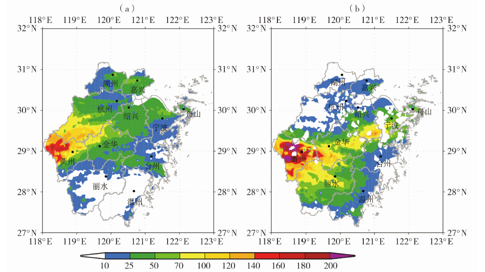
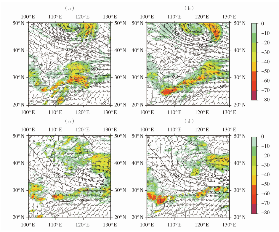
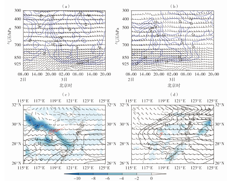
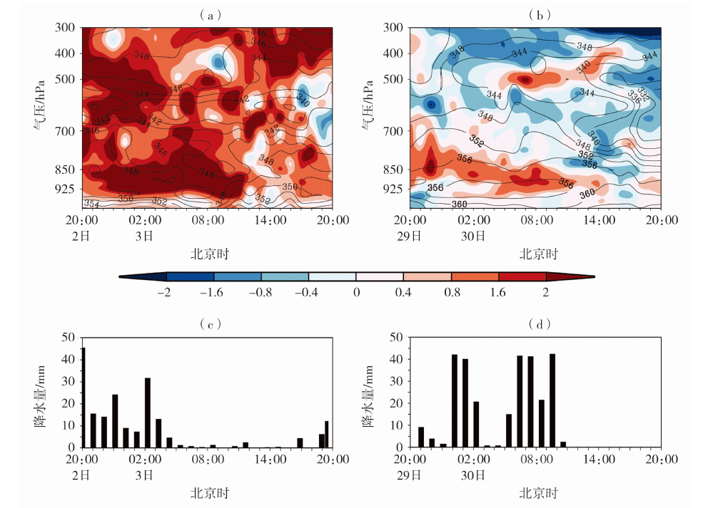
利用浙江省常规气象观测资料、ERA5逐小时再分析资料、FY-4A卫星黑体亮度温度(TBB)资料,对2020年6月3日、6月30日两次暴雨过程进行对比分析。结果表明:(1)6月3日暴雨过程(简称“6·03”过程)发生在季风槽背景下,浙江省500 hPa处于槽前西南气流中,850 hPa为暖切变;而6月30日过程(简称“6.30”过程)发生在东北冷涡背景下,浙江省500 hPa处于冷暖气流交汇中,850 hPa为冷切变。两次过程降水落区相似,均集中在浙西地区,呈东西向带状分布,但“6·30”过程暴雨区范围更广,暴雨中心雨量和过程雨量更大,小时雨强更强,强降水持续时间更长。(2)两次过程均为对流不稳定性降水,但强降水落区发生在急流的不同位置。“6·03”过程为暖切变型暖区暴雨,对流云团“列车效应”显著,降水落区位于急流前方水汽通量强辐合区内,而“6·30”过程梅雨锋为西风辐合型锋生,对流云团为后向传播路径,降水落区位于急流轴附近的水汽通量强辐合区内。700 hPa水汽通量辐合大值区及强度与未来6 h强降水落区、强度相对应,这在梅汛期暴雨预报中有一定参考性。(3)降水类型不同,对应锋生作用不同,对1 h强降水有指示意义的锋区高度也不同,在梅汛期暴雨预报中要充分考虑不同降水类型与不同锋生作用在不同高度的对应性。

关键词: 暖区暴雨, 水汽通量散度, 锋生, 后向传播

Abstract:

Based on conventional meteorological observation data of Zhejiang Province, ERA5 hourly reanalysis data (0.25°×0.25°) and blackbody brightness temperature (TBB) of FY-4A satellite, the two rainstorm processes occurring on June 3 and June 30 in 2020 were compared and analyzed. The results are as follows: (1) The rainstorm on June 3 (short for “6·03”) occurred in the background of monsoon trough, and there were southwest flow in front of the trough at 500 hPa and warm shear at 850 hPa over Zhejiang Province,while the rain storm on June 30 (short for “6·30”) occurred in the background of northeast cold vortex, there were confluence of cold and warm air at 500 hPa and cold shear at 850 hPa. For two rainstorm processes, their rainfall areas were similar, all concentrating in west Zhejiang and presenting east-west belt distribution. But for the “6·30” process, the rainfall area was wider, both the center rainfall and process rainfall were larger, the hourly rainfall intensity was stronger, and the duration of heavy rainfall was longer. (2) Both two rainstorm processes were convective unstable precipitation, but the heavy rainfall areas were in different positions of the jet stream. The “6·03” process was a warm shear type rainstorm in the warm region, the “train effect” of convective cloud clusters was significant and precipitation was located in the strong convergence area of water vapor flux in front of the jet. During the “6·30”, the Meiyu front was a westerly convergence frontogenesis, and the convective cloud clusters presented a backward propagation path, the precipitation was located in the strong convergence area of water vapor flux near the jet axis. The maximum convergence area of water vapor flux and intensity at 700 hPa corresponded to the falling area and intensity of heavy precipitation in the next six hours, which had a certain reference in rainstorm forecast in the Meiyu season. (3) Due to different precipitation types, the corresponding frontogenesis was different, and the height of the frontal zone indicating one hour heavy rainfall was also different. So in the forecast of rainstorm in the Meiyu season, the correspondence of different precipitation types and frontogenesis at different heights should be fully considered.

Key words: warm zone rainstorm, water vapor flux divergence, frontogenesis, backward propagation

中图分类号: