干旱气象 ›› 2022, Vol. 40 ›› Issue (1): 30-40.DOI: 10.11755/j.issn.1006-7639(2022)-01-0030
天山南坡暖季暴雨过程的水汽来源及输送特征
庄晓翠1,2( ), 李博渊2, 赵江伟2, 李建刚1, 张林梅3
- 1.中国气象局乌鲁木齐沙漠气象研究所,新疆 乌鲁木齐 830002
2.新疆阿勒泰地区气象局,新疆 阿勒泰 836500
3.新疆气象台,新疆 乌鲁木齐 830002
-
收稿日期:2021-07-28修回日期:2021-11-15出版日期:2022-02-28发布日期:2022-02-28 -
作者简介:庄晓翠(1964— ),重庆人,正研级高级工程师,主要从事天气预报及灾害性天气机理研究. E-mail: zxcxjalt@163.com。 -
基金资助:国家自然基金(U2003106);新疆维吾尔自治区自然科学基金共同资助(2021D01A01)
Water vapor source and transport characteristics of rainstorm processes in warm season on southern slope of the Tianshan Mountains
ZHUANG Xiaocui1,2(), LI Boyuan2, ZHAO Jiangwei2, LI Jiangang1, ZHANG Linmei3
- 1. Institute of Desert Meteorology of China Meteorological Administration, Urumqi 830002, China
2. Altai Meteorological Bureau of Xinjiang Uygur Autonomous Region, Altai 836500, Xinjiang, China
3. Xinjiang Meteorological Observatory, Urumqi 830002, China
-
Received:2021-07-28Revised:2021-11-15Online:2022-02-28Published:2022-02-28
摘要:
利用1981—2020年5—9月天山南坡16个气象站逐日降水资料和NCEP/NCAR GDAS再分析资料,分析天山南坡暖季暴雨过程的环流形势,并采用HYSPLIT模式,模拟追踪水汽源地及输送特征。结果表明:天山南坡暖季暴雨主要发生在南亚高压双体型、500 hPa以上西南急流(气流)、700 hPa切变辐合以及天山地形辐合抬升的重叠区域。水汽主要源自中亚、大西洋及其沿岸、地中海和黑海及其附近,经TKAP(塔吉克斯坦、吉尔吉斯坦、阿富汗东北部、巴基斯坦北部和印度西北部)、南疆、北疆关键区,分别从偏西、偏南、偏北通道输入暴雨区,700 hPa以上偏西通道、以下偏北通道占主导地位,且贡献最大的是南疆关键区。源自中亚的水汽主要输送至暴雨区700 hPa及以下,对暴雨的贡献较大,且沿途损失较大;源自大西洋及其沿岸、地中海和黑海及其附近的水汽主要输送至暴雨区700 hPa以上,对暴雨的贡献较小。另外,中低层还存在源自北疆、南疆、北美洲东部、蒙古的水汽。基于上述特征,建立了天山南坡暖季暴雨过程水汽三维精细化结构模型。
中图分类号:
引用本文
庄晓翠, 李博渊, 赵江伟, 李建刚, 张林梅. 天山南坡暖季暴雨过程的水汽来源及输送特征[J]. 干旱气象, 2022, 40(1): 30-40.
ZHUANG Xiaocui, LI Boyuan, ZHAO Jiangwei, LI Jiangang, ZHANG Linmei. Water vapor source and transport characteristics of rainstorm processes in warm season on southern slope of the Tianshan Mountains[J]. Journal of Arid Meteorology, 2022, 40(1): 30-40.
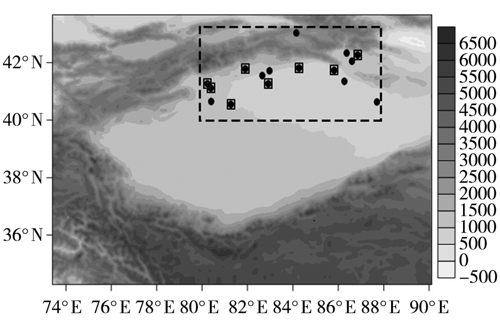
图1 天山南坡(虚线矩形)及周边地形高度(灰色阴影,单位:m)和气象站点(黑点)分布(黑色小方框包围的点为暴雨中心)
Fig.1 The distribution of terrain height (grey shadows, Unit: m) on southern slope of the Tianshan Mountains (dashed rectangle) and its surroundings and weather stations (black dots) (the black dots enclosed by box for rainstorm centers)
图1 天山南坡(虚线矩形)及周边地形高度(灰色阴影,单位:m)和气象站点(黑点)分布(黑色小方框包围的点为暴雨中心)
Fig.1 The distribution of terrain height (grey shadows, Unit: m) on southern slope of the Tianshan Mountains (dashed rectangle) and its surroundings and weather stations (black dots) (the black dots enclosed by box for rainstorm centers)
表1 1981—2020年天山南坡暖季10次暴雨过程概况
Tab.1 Survey of 10 rainstorm processes in warm season on southern slope of the Tianshan Mountains from 1981 to 2020
| 日 期 | 持续 时间/d | 暴雨站次 | 研究区最大日雨量及站点 | 日平均 雨量/mm | 最大过程雨量及站点 | ||||
|---|---|---|---|---|---|---|---|---|---|
| 研究区 | 过程 | 雨量/mm | 观测站 | 雨量/mm | 观测站 | ||||
| 1981年7月31日 | 1 | 3 | 4 | 30.0 | 巴仑台 | 27.3 | 30.0 | 巴仑台 | |
| 1987年6月11日 | 1 | 4 | 4 | 58.4 | 沙雅 | 41.2 | 58.4 | 沙雅 | |
| 1992年6月18日 | 1 | 3 | 4 | 40.2 | 沙雅 | 35.5 | 40.2 | 沙雅 | |
| 1992年7月2—5日 | 4 | 6 | 17 | 57.3 | 和硕 | 35.3 | 94.7 | 天池 | |
| 1997年5月11日 | 1 | 4 | 4 | 57.7 | 拜城 | 41.2 | 57.7 | 拜城 | |
| 1997年6月29日 | 1 | 3 | 4 | 31.7 | 阿克苏 | 28.3 | 31.7 | 阿克苏 | |
| 2007年7月16—17日 | 2 | 3 | 14 | 39.9 | 轮台 | 45.6 | 61.5 | 和丰 | |
| 2010年7月29日 | 1 | 3 | 4 | 31.7 | 拜城 | 28.6 | 31.7 | 拜城 | |
| 2013年6月16—19日 | 4 | 6 | 7 | 67.8 | 温宿 | 37.6 | 67.8 | 温宿 | |
| 2015年9月8日 | 1 | 3 | 3 | 25.7 | 阿拉尔 | 25.2 | 25.7 | 阿拉尔 | |
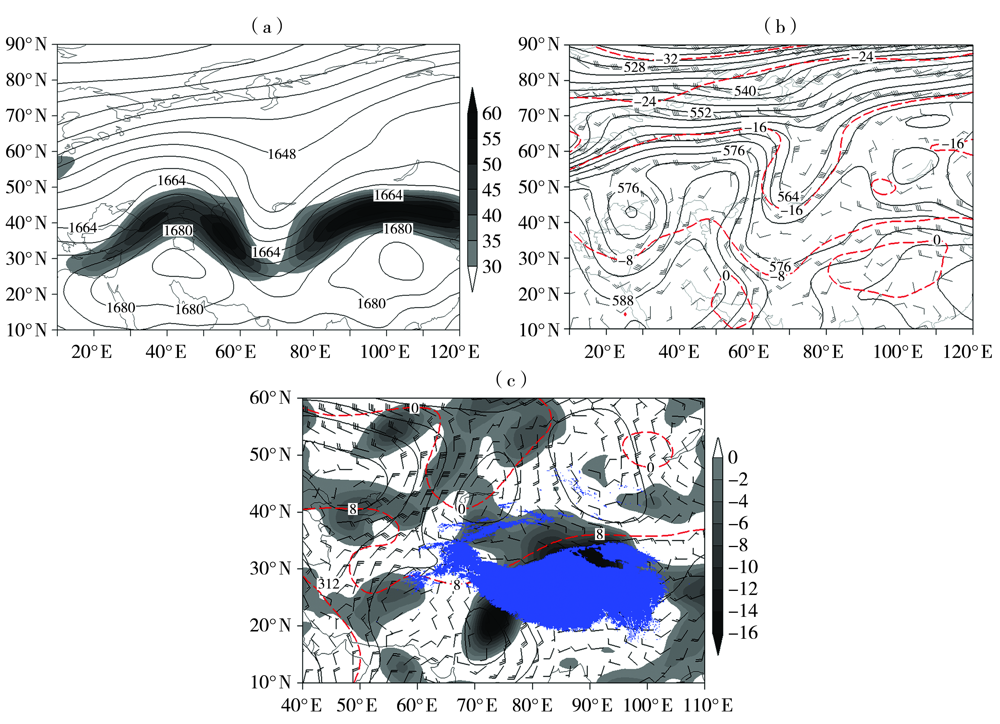
图2 天山南坡暖季暴雨过程的环流形势 (a)100 hPa位势高度场(等值线,单位:dagpm)和200 hPa高空急流(阴影,单位:m·s-1), (b)500 hPa位势高度场(黑色实等值线,单位:dagpm)、风场(风羽,单位:m·s-1)及温度场(红色虚等值线,单位:℃), (c)700 hPa位势高度场(黑色实等值线,单位:dagpm)、风场(风羽,单位:m·s-1)、 温度场(红色虚等值线,单位:℃)及水汽通量散度(阴影,单位:10-6 g·hPa-1·cm-2·s-1) (蓝色区域为3000 m以上高度的青藏高原)
Fig.2 Circulation situations of rainstorm process in warm season on southern slope of the Tianshan Mountains (a) 100 hPa geopotential height field (isolines, Unit: dagpm) and 200 hPa upper-level jet stream (shadow, Unit: m·s-1), (b) 500 hPa geopotential height field (black solid isolines, Unit: dagpm), wind field (barbs, Unit: m·s-1) and temperature field (red dotted isolines, Unit: ℃), (c) 700 hPa geopotential height field (black solid isolines, Unit: dagpm), wind field (barbs, Unit: m·s-1), temperature field (red dotted isolines, Unit: ℃) and water vapor flux divergence (shadows, Unit: 10-6 g·hPa-1·cm-2·s-1) (the blue area for the Tibet Plateau with elevation more than 3000 m)

图3 天山南坡暖季10次暴雨过程500 hPa水汽后向轨迹的空间分布及高度变化 (a) 31 July 1981, (b) 11 June 1987, (c) 18 June 1992, (d) 4 July 1992, (e) 11 May 1997, (f) 29 June 1997, (g) 16 July 2007, (h) 29 July 2010, (i) 17 June 2013, (j) 8 September 2015 (1~5为水汽后向轨迹,其后面的百分数表示水汽贡献率)
Fig.3 Spatial distribution and height variation of 500 hPa water vapor backward trajectory for 10 rainstorm processes in warm season on southern slope of the Tianshan Mountains (a)1981-07-31,(b)1987-06-11,(c)1992-06-18,(d)1992-07-04,(e)1997-05-11,(f)1997-06-29,(g)2007-07-16,(h)2010-07-29,(i)2013-06-17,(j)2015-09-08 (Numbers from 1 to 5 represent water vapor backward trajectories, and the percentage followed by number is contribution rate of water vapor)
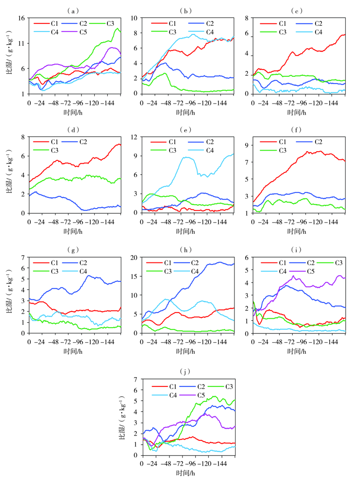
图4 天山南坡暖季10次暴雨过程500 hPa不同水汽后向轨迹的比湿逐时变化 (a) 31 July 1981, (b) 11 June 1987, (c) 18 June 1992, (d) 4 July 1992, (e) 11 May 1997, (f) 29 June 1997, (g) 16 July 2007, (h) 29 July 2010, (i) 17 June 2013, (j) 8 September 2015 (C1、C2、C3、C4、C5分别对应图3中1、2、3、4、5轨迹)
Fig.4 The hourly change of specific humidity under different water vapor backward trajectory on 500 hPa for 10 rainstorm processes in warm season on southern slope of the Tianshan Mountains (a)1981-07-31,(b)1987-06-11,(c)1992-06-18,(d)1992-07-04,(e)1997-05-11,(f)1997-06-29,(g)2007-07-16,(h)2010-07-29,(i)2013-06-17,(j)2015-09-08 (C1, C2, C3, C4, C5 correspond to trajectory 1, 2, 3, 4, 5 in Fig.3, respectively)
表2 天山南坡暖季暴雨500 hPa水汽源地及水汽贡献率、高度和比湿
Tab.2 The 500 hPa water vapor source of rainstorm in warm season on southern slope of the Tianshan Mountains and the contribution rate, height and specific humidity of water vapor
| 关键区 | 水汽源地 | 轨迹/ 条 | 贡献率/% | 源地水汽高度/m | 源地比湿/(g·kg-1) | 暴雨区比湿/(g·kg-1) | 损失 率/% | |||||||
|---|---|---|---|---|---|---|---|---|---|---|---|---|---|---|
| 范围 | 平均 | 范围 | 平均 | 范围 | 平均 | 范围 | 平均 | |||||||
| TKAP | 源地Ⅰ | 10 | 14~46 | 28 | 54~2952 | 1315 | 4.08~7.52 | 6.12 | 1.84~3.83 | 2.68 | 56 | |||
| 源地Ⅱ | 8 | 7~39 | 18 | 2167~7310 | 5529 | 0.57~5.10 | 1.67 | 1.00~2.42 | 1.60 | 4 | ||||
| 源地Ⅲ | 5 | 14~43 | 30 | 3432~5249 | 4448 | 1.43~2.69 | 1.87 | 0.54~1.87 | 1.52 | 19 | ||||
| 其他源地 | 10 | 4~50 | 24 | 62~7521 | 3755 | 0.18~18.38 | 5.13 | 0.78~3.86 | 2.29 | 55 | ||||
| 南疆 | 北疆、蒙古、 乌克兰、北欧 | 5 | 11~46 | 29 | 143~6316 | 3297 | 0.66~8.81 | 3.50 | 1.78~3.94 | 2.70 | 23 | |||
| 北疆 | 北美洲、 大西洋沿岸、 巴尔喀什湖 | 3 | 11~14 | 13 | 54~8510 | 4925 | 0.60~9.25 | 3.74 | 1.55~1.83 | 1.67 | 55 | |||
表3 天山南坡暖季暴雨700 hPa水汽源地及水汽贡献率、高度和比湿
Tab.3 The 700 hPa water vapor source of rainstorm in warm season on southern slope of the Tianshan Mountains and the contribution rate, height and specific humidity of water vapor
| 关键区 | 水汽源地 | 轨迹/ 条 | 贡献率/% | 源地水汽高度/m | 源地比湿/(g·kg-1) | 暴雨区比湿/(g·kg-1) | 损失 率/% | |||||||
|---|---|---|---|---|---|---|---|---|---|---|---|---|---|---|
| 范围 | 平均 | 范围 | 平均 | 范围 | 平均 | 范围 | 平均 | |||||||
| TKAP | 源地Ⅰ | 12 | 11~54 | 30 | 81~2931 | 705 | 1.88~8.16 | 5.61 | 3.20~5.80 | 4.70 | 16 | |||
| 其他Ⅰ源地 | 6 | 4~29 | 14 | 34~4973 | 3262 | 0.90~4.40 | 2.62 | 2.92~5.39 | 4.32 | -65 | ||||
| 南疆 | 源地Ⅰ | 8 | 18~57 | 35 | 2~4406 | 1262 | 2.61~8.57 | 5.98 | 3.23~7.24 | 4.91 | 18 | |||
| 其他Ⅱ源地 | 4 | 14~43 | 25 | 0~28 | 15 | 6.60~9.50 | 8.42 | 4.63~5.80 | 5.23 | 38 | ||||
| 北疆 | 源地Ⅰ、 北欧、乌克兰 和新地岛 | 7 | 11~46 | 25 | 324~4180 | 2215 | 1.17~7.80 | 4.11 | 2.46~5.22 | 3.92 | 5 | |||
表4 天山南坡暖季暴雨850 hPa水汽源地及水汽贡献率、高度和比湿
Tab.4 The 850 hPa water vapor source of rainstorm in warm season on southern slope of the Tianshan Mountains and the contribution rate, height and specific humidity of water vapor
| 关键区 | 水汽源地 | 轨迹/ 条 | 贡献率/% | 源地水汽高度/m | 源地比湿/(g·kg-1) | 暴雨区比湿/(g·kg-1) | 损失 率/% | |||||||
|---|---|---|---|---|---|---|---|---|---|---|---|---|---|---|
| 范围 | 平均 | 范围 | 平均 | 范围 | 平均 | 范围 | 平均 | |||||||
| 北疆 | 源地Ⅰ | 15 | 18~89 | 42 | 1~596 | 71 | 3.77~12.58 | 7.91 | 4.63~7.57 | 5.86 | 26 | |||
| 其他Ⅲ源地 | 6 | 7~21 | 14 | 4~2287 | 751 | 1.70~10.40 | 5.78 | 5.48~7.78 | 6.40 | -11 | ||||
| TKAP | 源地Ⅰ 和北疆 | 6 | 11~50 | 29 | 13~505 | 139 | 3.73~7.28 | 5.90 | 4.73~6.65 | 5.69 | 4 | |||
| 南疆 | 巴尔喀什湖 和北疆 | 4 | 18~50 | 29 | 27~40 | 35 | 5.04~9.82 | 7.63 | 5.10~7.60 | 6.41 | 16 | |||
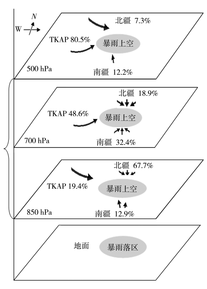
图5 天山南坡暖季暴雨过程的水汽三维精细化结构模型
Fig.5 Three-dimensional fine structure model of water vapor of rainstorm processes on southern slope of the Tianshan Mountains
图5 天山南坡暖季暴雨过程的水汽三维精细化结构模型
Fig.5 Three-dimensional fine structure model of water vapor of rainstorm processes on southern slope of the Tianshan Mountains
表5 天山南坡暖季暴雨区不同高度比湿与源地水汽高度、比湿和贡献率之间的相关关系
Tab.5 The correlation between specific humidity on different heights of rainstorm area on southern slope of the Tianshan Mountains in warm season and water vapor height, specific humidity, contribution rate over water vapor source area
| 源地气象要素 | 暴雨区比湿 | ||||||||
|---|---|---|---|---|---|---|---|---|---|
| 500 hPa | 700 hPa | 850 hPa | 500 hPa | 700 hPa | 850 hPa | 500 hPa | 700 hPa | 850 hPa | |
| 水汽高度 | -0.536** | 0.072 | -0.145 | - | - | - | -0.065 | 0.227 | 0.260 |
| 气团比湿 | 0.627** | 0.302 | 0.397* | 0.393** | 0.399* | 0.457* | - | - | - |
| 水汽贡献率 | - | - | - | 0.094 | 0.183 | -0.432* | -0.081 | 0.065 | -0.409* |
| [1] | 施雅风, 沈永平, 李栋梁, 等. 中国西北气候由暖干向暖湿转型的特征和趋势探讨[J]. 第四纪研究, 2003, 23(2):152-164. |
| [2] | 张云惠, 贾丽红, 崔彩霞, 等. 2000—2011年新疆主要气象灾害时空分布特征[J]. 沙漠与绿洲气象, 2013, 7(增刊):20-23. |
| [3] | 黄荣辉, 陈际龙. 我国东、西部夏季水汽输送特征及其差异[J]. 大气科学, 2010, 34(6):1035-1045. |
| [4] | 杨柳, 赵俊虎, 封国林. 中国东部季风区夏季四类雨型的水汽输送特征及差异[J]. 大气科学, 2018, 42(1):81-95. |
| [5] | 孙力, 马梁臣, 沈柏竹, 等. 2010年7—8月东北地区暴雨过程的水汽输送特征分析[J]. 大气科学, 2016, 40(3):630-646. |
| [6] | 阙志萍, 凌婷, 吴凡, 等. 江西一次连续大暴雨的水汽特征分析[J]. 干旱气象, 2021, 39(1):76-86. |
| [7] | 杨浩, 江志红, 刘征宇, 等. 基于拉格朗日法的水汽输送气候特征分析——江淮梅雨和淮北雨季的对比[J]. 大气科学, 2014, 38(5):965-973. |
| [8] | 孙建华, 汪汇洁, 卫捷, 等. 江淮区域持续性暴雨过程的水汽源地和输送特征[J]. 气象学报, 2016, 74(4):542-555. |
| [9] | 王志毅, 高庆九, 胡邦辉, 等. 近50 a江淮地区梅雨期水汽输送特征研究[J]. 大气科学学报, 2017, 40(1):48-60. |
| [10] | 张家宝, 邓子风. 新疆降水概论[M]. 北京: 气象出版社, 1987:92-104. |
| [11] |
HUANG W, FENG S, CHEN J H, et al. Physical mechanisms of summer precipitation variations in the Tarim Basin in northwestern China[J]. Journal of Climate, 2015, 28(9):3579-3591.
DOI URL |
| [12] | 杨莲梅, 张云惠, 汤浩. 2007年7月新疆三次暴雨过程的水汽特征分析[J]. 高原气象, 2012, 31(4):963-973. |
| [13] |
曾勇, 杨莲梅. 新疆西部一次极端暴雨事件的成因分析[J]. 高原气象, 2018, 37(5):1220-1232.
DOI |
| [14] |
张云惠, 陈春艳, 杨莲梅, 等. 南疆西部一次罕见暴雨过程的成因分析[J]. 高原气象, 2013, 32(1):191-200.
DOI |
| [15] | 张云惠, 李海燕, 蔺喜禄, 等. 南疆西部持续性暴雨环流背景及天气尺度的动力过程分析[J]. 气象, 2015, 41(7):816-824. |
| [16] | 庄晓翠, 李健丽, 李博渊, 等. 北疆北部2次区域性暴雨的中尺度环境场分析[J]. 沙漠与绿洲气象, 2014, 8(6):23-30. |
| [17] | 谢泽明, 周玉淑, 杨莲梅. 新疆降水研究进展综述[J]. 暴雨灾害, 2018, 37(3):204-212. |
| [18] | 庄晓翠, 李如琦, 李博渊, 等. 中亚低涡造成新疆北部区域暴雨成因分析[J]. 气象, 2017, 43(8):924-935. |
| [19] | 陈春艳, 孔期, 李如琦. 天山北坡一次特大暴雨过程诊断分析[J]. 气象, 2012, 38(1):72-80. |
| [20] | 刘晶, 周玉淑, 杨莲梅, 等. 伊犁河谷一次极端强降水事件水汽特征分析[J]. 大气科学, 2019, 43(5):959-974. |
| [21] |
庄晓翠, 李博渊, 秦榕, 等. 新疆东部一次区域极端暴雨环境场特征[J]. 高原气象, 2020, 39(5):947-959.
DOI |
| [22] | 努尔比亚·吐尼牙孜, 张超, 李泽巍, 等. 南疆西部2016年8月4次暴雨过程特征分析[J]. 干旱气象, 2019, 37(2):301-311. |
| [23] | 刘国强, 佟欣怡, 邓京, 等. 2012年6月巴州一次暴雨水汽输送特征[J]. 沙漠与绿洲气象, 2019, 13(2):22-31. |
| [24] | 刘国强, 佟欣怡, 杨莲梅, 等. 巴州地区一次罕见短时强降水过程诊断分析[J]. 气象与环境学报, 2017, 33(6):16-24. |
| [25] | DRAXIER R R, HESS G D. An overview of HYSPLIT_4 modeling system for trajectories dispersion and deposition[J]. Australian Meteorological Magazine, 1998, 47(4):295-308. |
| [26] |
MAKRA L, MATYASOVSZKY I, GUBA Z, et al. Monitoring the long-range transport effects on urban PM10 levels using 3D clusters of backward trajectories[J]. Atmospheric Environment, 2011, 45(16):2630-2641.
DOI URL |
| [27] |
STOHL A, JAMES P. A Lagrangian analysis of the atmospheric branch of the global water cycle. Part Ⅰ: Method description, validation, and demonstration for the August 2002 flooding in central Europe[J]. Journal of Hydrometeorology, 2004, 5(4):656-678.
DOI URL |
| [28] |
任梅芳, 庞博, 徐宗学, 等. 基于随机森林模型的雅鲁藏布江流域气温降尺度研究[J]. 高原气象, 2018, 37(5):1241-1253.
DOI |
| [29] |
庄晓翠, 赵江伟, 李健丽, 等. 新疆阿勒泰地区短时强降水流型及环境参数特征[J]. 高原气象, 2018, 37(3):675-685.
DOI |
| [30] | 李博渊, 马宏君, 庄晓翠, 等. 2010—2016年新疆阿勒泰地区暖季降水日变化特征[J]. 干旱气象, 2017, 35(5):797-805. |
| [1] | 阙志萍, 凌婷, 吴凡, 陈云辉. 江西一次连续大暴雨的水汽特征分析[J]. 干旱气象, 2021, 39(1): 76-86. |
| [2] | 黄勤, 黄鑫, 李亚丽. 陕西榆林地区一次暴雨过程三维风场结构演变特征[J]. 干旱气象, 2020, 38(5): 747-754. |
| [3] | 段云霞, 李得勤, 田莉, 李霞, 吴宇童, 白华, 班伟龙. 辽宁省中部一次重污染过程城市间污染差异及成因[J]. 干旱气象, 2020, 38(2): 301-312. |
| [4] | 彭舒龄,周树道,王 敏,任尚书,沈 奥. 南京市一次雾霾天气过程的阶段性特征与成因[J]. 干旱气象, 2018, 36(2): 282-289. |
| [5] | 孙国武,李震坤,陈伯民,信飞,梁萍. 长江下游地区6—9月暴雨过程延伸期预报的探索[J]. 干旱气象, 2017, 35(5): 784-790. |
| [6] | 张勇,张亚萍,牟容,杨春,何跃. 组网雷达在暴雨过程低层水平风场反演试验初步研究[J]. 干旱气象, 2017, 35(4): 634-640. |
| [7] | 马敬霞, 肖志强, 魏邦宪. 甘肃陇南地震灾区2次暴雨过程的诊断对比[J]. J4, 2009, 27(2): 127-134. |
| [8] | 聂晶鑫, 陆晓静, 李 蓉. 宁夏一次短时暴雨天气的跟踪预报分析[J]. J4, 2009, 27(2): 185-189. |
| 阅读次数 | ||||||
|
全文 |
|
|||||
|
摘要 |
|
|||||
