干旱气象 ›› 2023, Vol. 41 ›› Issue (3): 463-473.DOI: 10.11755/j.issn.1006-7639(2023)-03-0463

• 论文 • 上一篇    下一篇

印度双低涡对青藏高原西部一次典型暴雪过程的影响

张入财1(), 王君2(), 陈超辉3, 付伟基4, 魏璐璐5   

  1. 1.中国人民解放军31308部队,四川 成都 610031
    2.河南省气象学会,河南省气象科学研究所,河南 郑州 450003
    3.国防科技大学气象海洋学院,湖南 长沙 410073
    4.中国人民解放军96606部队,河南 洛阳 471000
    5.河南省三门峡市气象局,河南 三门峡 472000
  • 收稿日期:2022-06-20 修回日期:2022-08-03 出版日期:2023-06-30 发布日期:2023-07-02
  • 通讯作者: 王君
  • 作者简介:张入财(1983—),男,重庆长寿人,高级工程师,硕士,主要从事高原灾害性天气预报技术研究。E-mail: zhangrc1021@163.com
  • 基金资助:
    国家自然科学基金项目(42275169)

Influence of Indian double vortexes on a typical snowstorm event in the west of Qinghai-Tibet Plateau

ZHANG Rucai1(), WANG Jun2(), CHEN Chaohui3, FU Weiji4, WEI Lulu5   

  1. 1. No. 31308 of PLA, Chengdu 610031, China
    2. Henan Provincial Meteorological Society, Henan Institute of Meteorological Sciences, Zhengzhou 450003, China
    3. College of Meteorology and Oceanography, National University of Defense Technology, Changsha 410073, China
    4. No. 96606 of PLA, Luoyang 471000, Henan, China
    5. Sanmenxia Meteorological Office of Henan Province, Sanmenxia 472000, Henan, China
  • Received:2022-06-20 Revised:2022-08-03 Online:2023-06-30 Published:2023-07-02
  • Contact: WANG Jun

摘要:

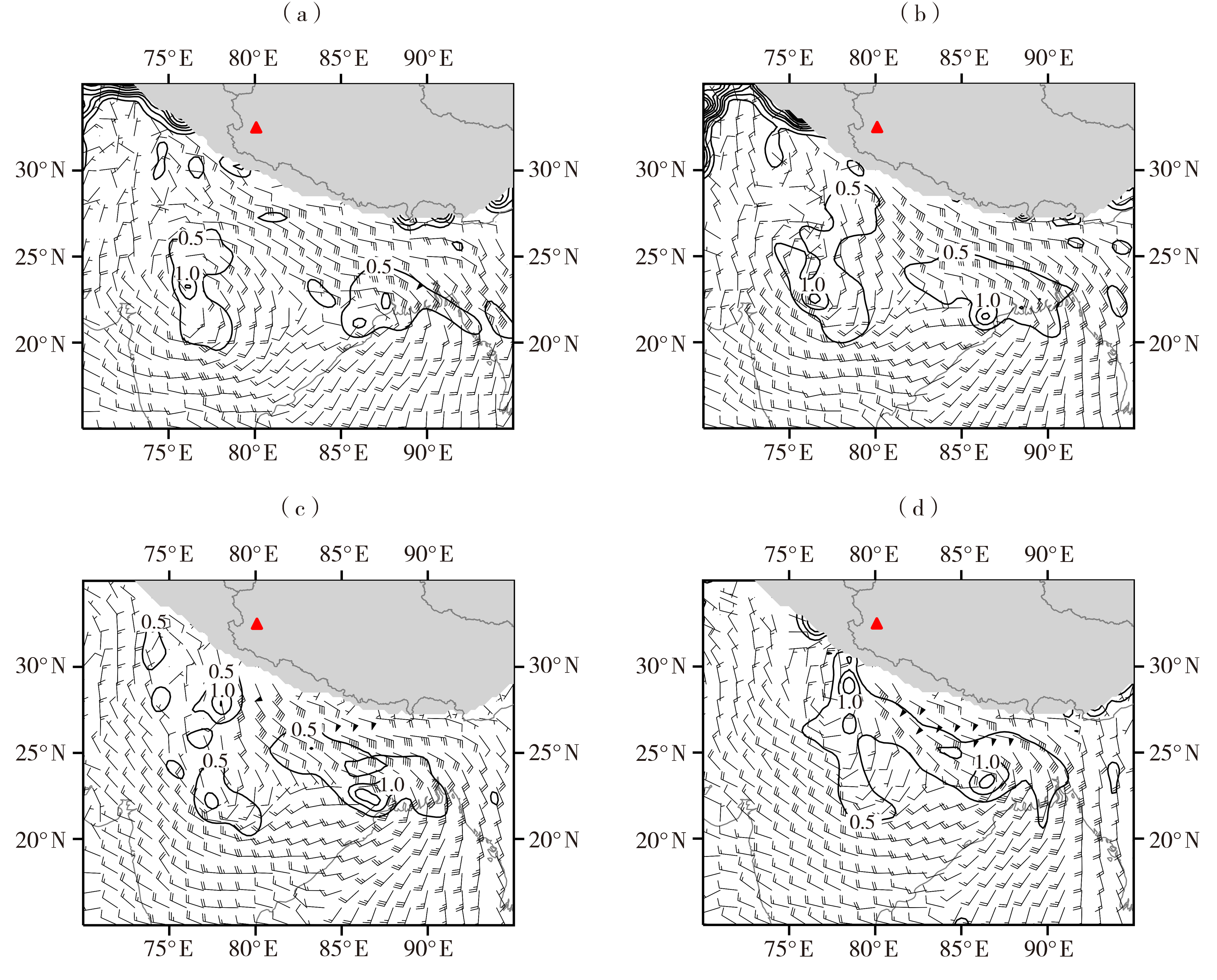
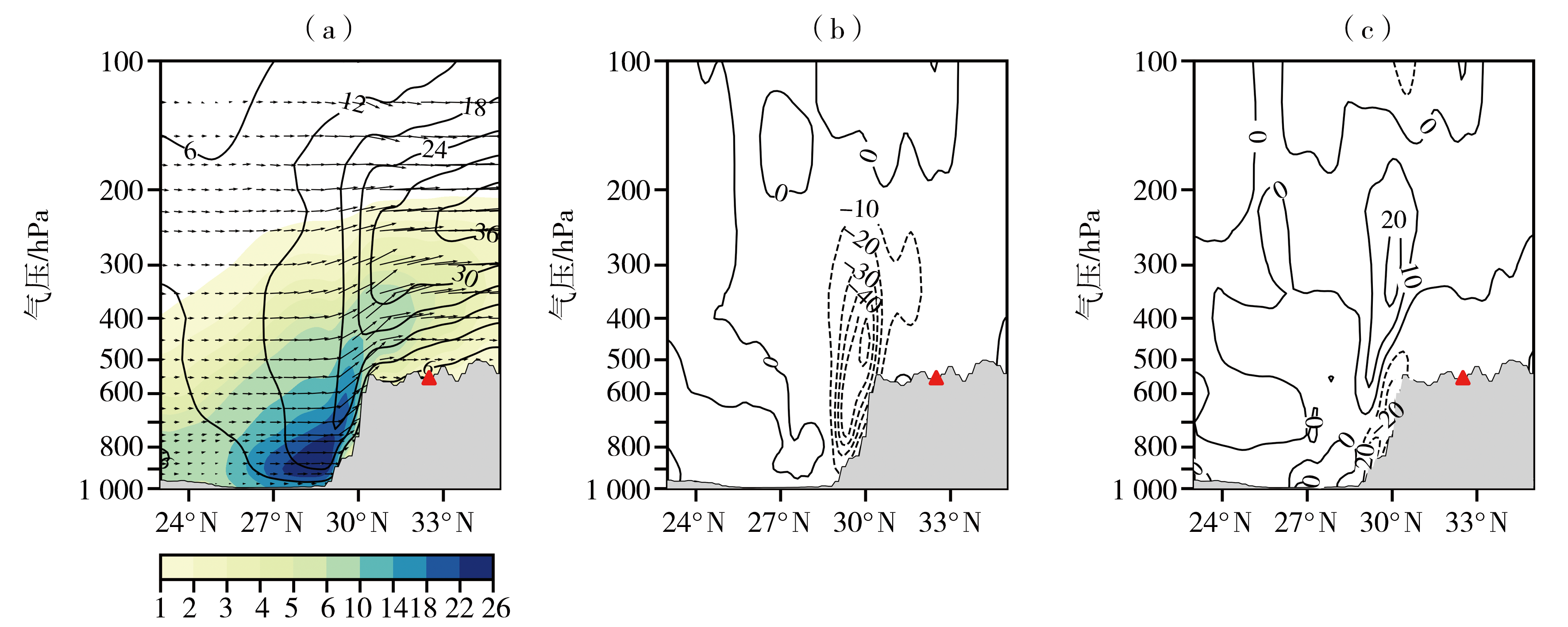
利用地面气象观测数据、欧洲中期天气预报中心ERA5再分析资料和FY-4A卫星云顶亮温数据,对2021年10月18—19日青藏高原西部暴雪过程进行综合分析,研究印度北部低涡对强降雪天气的贡献。结果表明:本次强降雪过程在南支槽东移和印度低涡异常活跃的背景下产生,南支槽前高空急流和印度北部东西向两个低涡为高原西部强降雪提供了有利的环流背景;降雪期间,印度北部至喜马拉雅山脉以南地区东南风低空急流大爆发,建立了一条由孟加拉湾向西输送的水汽通道,使得孟加拉湾水汽能够向西输送;生成于印度西北地区的对流层低涡系统一方面阻挡水汽继续向西输送,有利于孟加拉湾的水汽在低涡东部聚集,另一方面增强低涡东部偏南气流与高原大地形之间的强迫作用,使得大量水汽能够源源不断地从对流层低层沿高原南坡陡峭地形向上爬升至高原,为强降雪天气提供充足水汽条件;高空位涡侵入是印度西北地区的低涡系统生成发展的重要原因。总的来看,印度北部的低涡系统在此次高原西部降雪天气中起了重要作用,在高原地区降雪预报业务中,有必要加强对低纬度地区对流层低层低涡系统的跟踪监测。

关键词: 暴雪, 南支槽, 双低涡, 位涡, 高低空急流

Abstract:

Based on the conventional meteorological observations, the ERA5 (0.25°×0.25°) reanalysis data and FY-4A satellite cloud top brightness temperature data, the snow storm in the western Tibet from October 18 to 19, 2021 was analyzed, and the contribution of the low vortexes in northern India to the heavy snowfall was further studied. The results show that the heavy snowfall occurred under the background of the South Branch trough moving eastward and the abnormal activity of the Indian vortex, the high-level jet in front of the South Branch trough and the east-west double vortexes in northern India provided favorable circulation background for the strong snowfall in the west of the plateau. During this snowfall process, from northern India to the south of the Himalayas, the southeast low-level jet burst, establishing a water vapor transport channel from the bay of Bengal to the west, so that the water vapor in the bay of Bengal can be transported to the west. The low vortex system that generated in northwest India, on the one hand, made the water vapor from the bay of Bengal gather in the east of the low vortex and blocked its continuous transport westward. On the other hand, it enhanced the forcing effect between the southerly wind in the east of the low vortex and the plateau topography, so a large amount of water vapor can be continuously transported from the lower troposphere along the steep terrain on the southern slope of the plateau to the plateau, which provided sufficient water for the strong snowfall. The invasion of high-level potential vorticity is the main reason for the formation and development of the low vortex system in northwest India. In general, the low-level vortex system in the lower troposphere in northern India played a key role in the heavy snowfall process. In snow forecast in the plateau areas, it is necessary to strengthen tracking and monitoring of low vortex system in the lower troposphere in the low latitude.

Key words: snow storm, the South Branch trough, double vortexes, potential vorticity, high and low level jets

中图分类号: