干旱气象 ›› 2021, Vol. 39 ›› Issue (06): 1017-1024.DOI: 10.11755/j.issn.1006-7639(2021)-06-1017

• 业务技术应用 • 上一篇    下一篇

2010—2019年青海省雷电灾害综合风险区划

李文辉1(), 刘鑫1, 吴让2, 钟元龙3, 买永瑞3, 王军4, 韩炳宏5()   

  1. 1.青海省共和县气象局,青海 共和 813000
    2.青海省兴海县气象局,青海 兴海 813300
    3.青海省海南藏族自治州气象局,青海 共和 813000
    4.青海省雷电灾害防御中心,青海 西宁 810001
    5.兰州大学草地农业生态系统国家重点实验室,甘肃 兰州 730000
  • 收稿日期:2020-12-14 修回日期:2021-04-08 出版日期:2021-12-30 发布日期:2021-12-31
  • 通讯作者: 韩炳宏
  • 作者简介:李文辉(1990— ),男,青海湟源人,硕士生,主要从事气象防灾减灾和智慧气象方面研究. E-mail: 673955375@qq.com

Comprehensive risk regionalization of lightning disaster over Qinghai Province from 2010 to 2019

LI Wenhui1(), LIU Xin1, WU Rang2, ZHONG Yuanlong3, MAI Yongrui3, WANG Jun4, HAN Binghong5()   

  1. 1. Meteorological Bureau of Gonghe County of Qinghai Province, Gonghe 813000, Qinghai, China
    2. Meteorological Bureau of Xinghai County of Qinghai Province, Xinghai 813300, Qinghai, China
    3. Meteorological Bureau of Hainan Tibetan Autonomous Prefecture of Qinghai Province, Gonghe 813000, Qinghai, China
    4. Lightning Disaster Defense Center of Qinghai Provence, Xining 810001, China
    5. State Key Laboratory of Grassland Agro-ecosystem, Lanzhou University, Lanzhou 730000, China
  • Received:2020-12-14 Revised:2021-04-08 Online:2021-12-30 Published:2021-12-31
  • Contact: HAN Binghong

摘要:

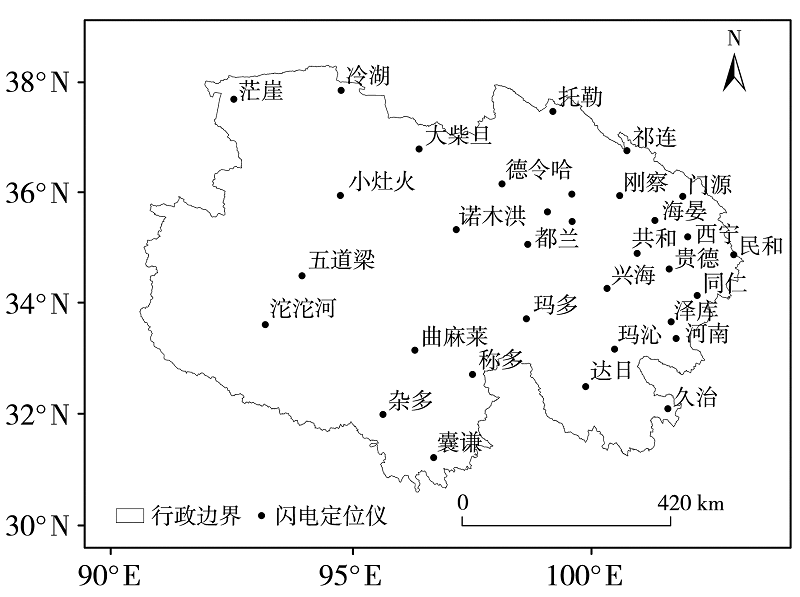
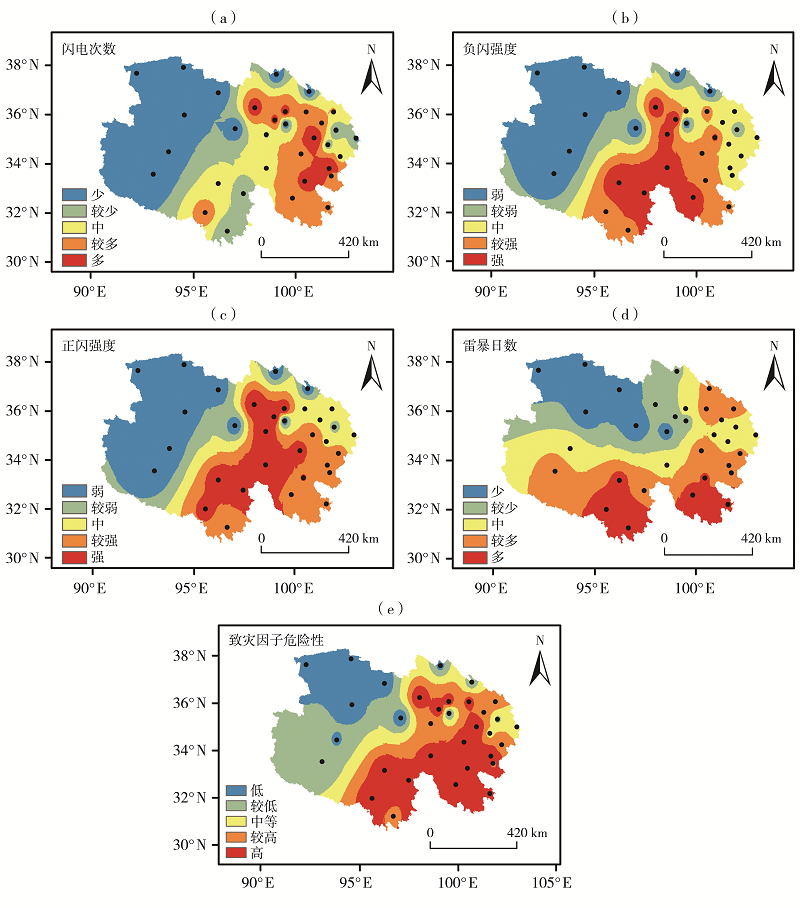
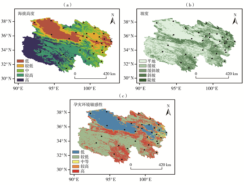
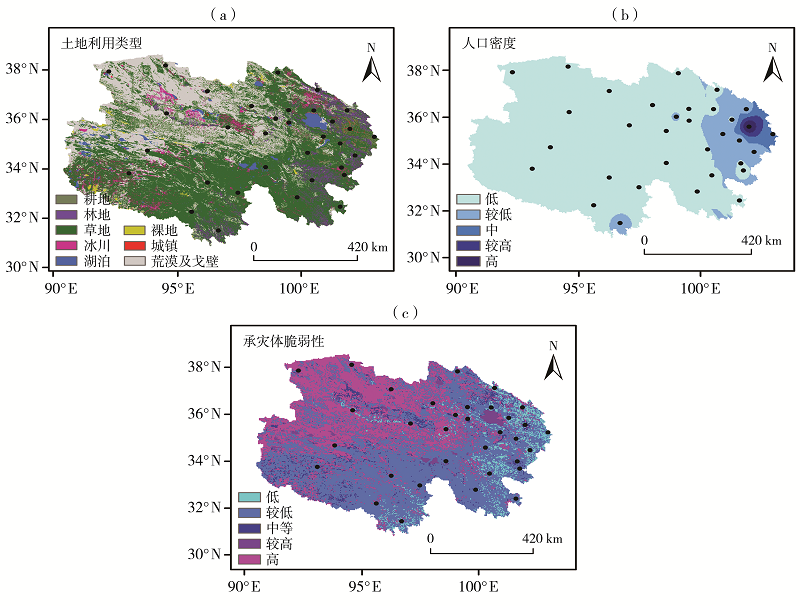
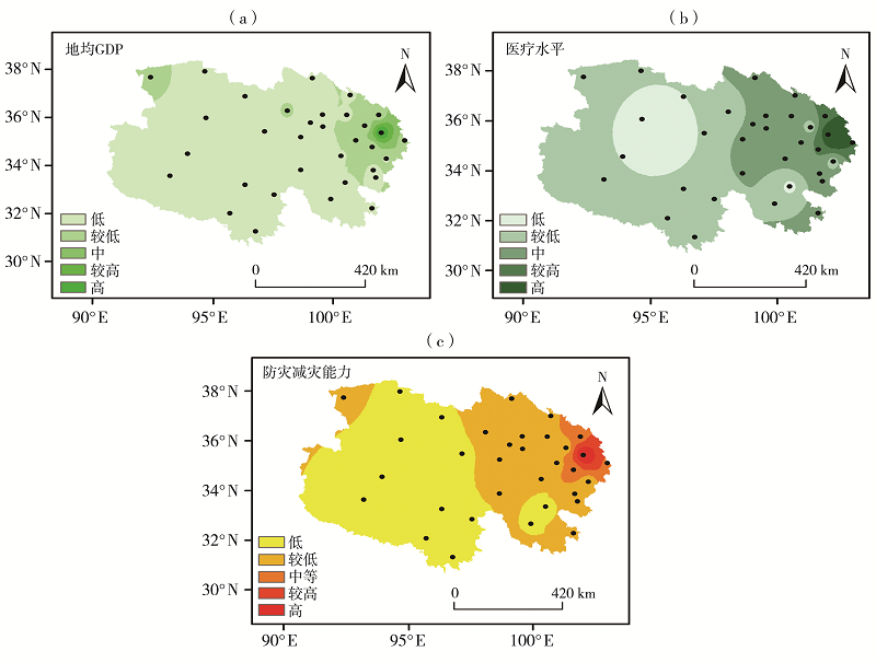
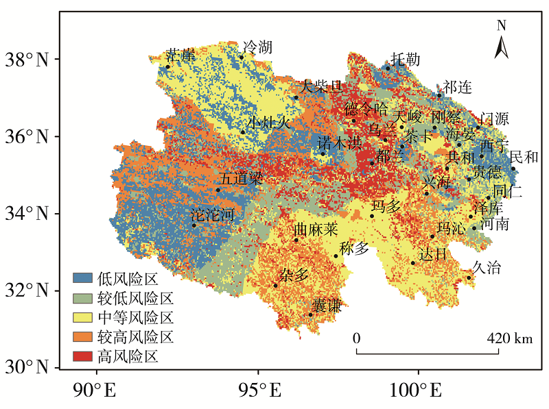
利用2010—2019年青海省33个闪电定位监测站闪电监测资料和48个市县区雷电灾害实时资料,采用数理统计和ArcGIS空间分析方法对青海省雷电灾害的空间分布及其风险区划进行了分析。结果表明,闪电次数较多、正负闪电流强度较强的地区主要分布于青海省中东部,雷暴日数高值区主要分布在祁连山区局地和青海省南部。青海省雷电灾害风险在空间上呈现出明显的地域分异特征。其中,高风险区主要位于境内的昆仑山、祁连山、念青唐古拉山、巴颜喀拉山和阿尼玛卿雪山以及青南牧区局部;柴达木盆地西北部、青南牧区东南部及环青海湖局部地区属中等风险地区;东部农业区大部、柴达木盆地局部、五道梁和沱沱河地区风险水平较低。

关键词: 青海省, 雷电灾害, 空间分布, 风险区划

Abstract:

Based on the lightning monitoring data of 33 lightning location monitoring stations and real-time lightning disaster data of 48 counties in Qinghai Province from 2010 to 2019, the spatial distribution and risk zoning of lightning disasters in Qinghai Province were analyzed by using mathematical statistics and ArcGIS spatial analysis method. The results show that the regions with more lightning frequency and strong positive and negative lightning current intensity were mainly distributed in the central and eastern part of Qinghai Province, while the areas with high value of thunderstorm days were mainly distributed in the Qilian Mountain and the southern part of Qinghai Province. The lightning disaster risk presented obvious regional differentiation in Qinghai Province. The high-risk regions were mainly located in Kunlun Mountains, Qilian Mountains, Nyainqentanglha Mountains, Bayan Har Mountains and Anyemaqen Snowy Mountains, as well as part of the southern grazing area of Qinghai Province. The northwest of Qaidam Basin, the southeast pastoral area of Qinghai Province and some areas around Qinghai Lake were medium-risk areas. The risk level in most of the eastern agricultural area, part of Qaidam Basin, Wudaoliang and Tuotuo River area was relatively lower.

Key words: Qinghai Province, lightning disaster, spatial distribution, risk zone

中图分类号: