

引言
三峡库区地处四川盆地与长江中下游平原的结合部,地形以山地为主,是三峡大坝修建蓄水形成的区域(孙晨和刘敏,2018;崔豪等,2021)。该区域处于亚热带季风区,降水年内和年际变化大,强降水易造成区域性洪涝灾害,并引发崩塌、滑坡、泥石流等次生灾害(吴翠红等,2013;矫梅燕,2014;董钊煜等,2020),是典型的生态环境脆弱区。此外,三峡库区位于长江流域腹地,发生在库区的降水直接汇入水库,由于强降水突发性强且强度大,导致产流快、反应时间短,给防洪带来极大困难,特别是在水库高水位运行情况下,直接影响整个流域的防洪调度及坝体安全(高琦等,2018)。因此,研究三峡库区降水特征及其变化规律,有助于筑牢防灾减灾第一道防线,也可为长江流域水患治理和水资源合理利用提供科学参考。
三峡库区夏季降水局地性强,大范围多雨洪涝时常伴有局地性降水偏少或大范围少雨干旱也会出现局地性降水偏多情况(宋文玲和杨义文,2003),且存在2~3 a、6~7 a及15 a左右的周期;夏季降水量整体呈增加趋势,并在1974年前后发生由少到多的突变(张永领等,2006),与长江中下游地区、西南地区乃至全国夏季降水变化趋势一致,这可能与西太平洋副热带高压增强有关(廖要明等,2007)。受限于资料分辨率,现有的三峡库区夏季降水特征研究多基于日尺度及以上资料,缺乏较长时间序列站点逐小时降水尤其是强降水精细化特征的探讨,而综合考量其强度和持续时间(简称“历时”)的研究更是鲜见。事实上,小时强降水因突发性强、生命史短、预测难度大等特点,给业务预报和科学研究带来巨大困难和挑战,而超过一定强度和历时的强降水事件更易造成灾害及严重威胁人民生命财产安全(Schumacher and Johnson,2005;陈炯等,2013;俞小鼎,2013;黄武斌等,2023)。因此,利用长时间序列的站点逐小时降水观测资料开展三峡库区夏季小时强降水和强降水事件精细化特征研究,对于深入认识该区域强降水天气及水资源高效利用、防灾减灾非常必要。
1 研究区概况
三峡库区跨越鄂中、川东山区岭谷地带,北屏大巴山,南依川鄂高原,地势起伏较大,东南高、西北低。库区内分布有25个国家级地面气象观测站,符合本研究时间序列长度要求的站点有20个,包括四川1站、湖北4站和重庆15站,站点海拔139.9~698.8 m,海拔最高、最低的站点分别为重庆南川站(107.11°E,29.16°N)、湖北三峡站(111.08°E,30.86°N),站点分布如图1所示。
图1

图1
研究区及周边地形高度(填充区,单位:m)及气象站点空间分布
Fig.1
The spatial distribution of terrain elevation (filled areas, Unit: m) and meteorological stations in the study area and its surrounding
2 资料与方法
选用中国气象局国家气象信息中心提供的1992—2021年夏季站点逐小时降水量观测资料和美国国家地球物理数据中心(National Geophysical Data Center,NGDC)提供的ETOPO1地形资料(http://www.ngdc.noaa.gov/mgg/global/etopo1source.html)。文中时间均为北京时。
采用小时降水量(R1h)大于等于20 mm作为小时强降水(Hourly Heavy Rainfall,HHR)阈值(伍红雨等,2017;杨丽杰等,2022)。对于某一站点,从降水出现到结束,其间最多只有连续1 h的间断,这样的一次过程称为一次降水事件。将一次降水事件中至少有1个时次R1h≥20 mm的定义为强降水事件(Heavy Rainfall Event,HRE)(Yu et al.,2007;李争辉和罗亚丽,2021),其起止时刻之间的时长称为历时,并根据历时长短划分为短历时(1~6 h)、中历时(7~12 h)和长历时(>12 h)3种类型。HRE的降水量与历时之比定义为HRE强度。站点的HRE频次定义为该站点HRE发生次数;站点的HRE平均降水量(平均历时)定义为该站点HRE总降水量(总历时)与总频次之比;站点的HRE平均强度定义为该站点HRE总降水量与总历时之比。
3 结果与分析
3.1 三峡库区夏季HHR时空分布特征
3.1.1 空间分布特征
受复杂地形环境影响,三峡库区气象要素空间差异显著(矫梅燕,2014)。对比分析1992—2021年三峡库区夏季总降水和HHR的平均降水量、频次、强度空间分布(图2),发现夏季总降水、HHR均在库区东南部出现降水量、频次高值中心,而库区中东部和西南部出现降水量低值区,且HHR降水量的局地性特征更明显,高值区和低值区相间分布,与频次空间分布对应较好,表明夏季HHR降水量主要源于其降水频次的贡献。与总降水强度(普遍为2.0~2.2 mm·h-1)相比,夏季HHR强度更强,普遍超过28.0 mm·h-1,且在库区东南部出现高值中心,展现出高强度特征。另外,由三峡库区夏季HHR降水量占比(与总降水量的百分比)空间分布(图略)可知,夏季HHR降水量占比普遍超过12%,最大占比20%出现在三峡站,表明三峡库区夏季HHR降水量对总降水量的贡献较大。
图2
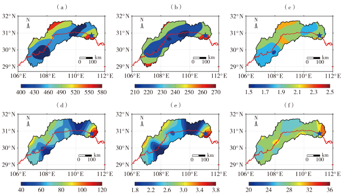
图2
1992—2021年三峡库区夏季总降水(a、b、c)和HHR(d、e、f)平均降水量(a、d,单位:mm)、频次(b、e,单位:次)、强度(c、f,单位:mm·h-1)空间分布
Fig.2
The spatial distribution of average precipitation (a, d, Unit: mm), frequency (b, e, Unit: times) and intensity (c, f, Unit: mm·h-1) of total rainfall (a, b, c) and HHR (d, e, f) in the Three Gorges Reservoir area in summer from 1992 to 2021
综上可知,三峡库区夏季HHR具有局地性和高强度性,库区东南部是HHR降水量、频次和强度中心,HHR降水量对总降水量的贡献较大,且主要源于HHR频次的贡献。
3.1.2 时间变化特征
图3是1992—2021年三峡库区平均夏季总降水量、HHR降水量及其占比的年际变化及趋势。可以看出,近30 a三峡库区夏季总降水量、HHR降水量及其占比均存在明显的年际变化,夏季站点平均HHR降水量、总降水量最多均出现在1998年,分别达135.3、797.9 mm,这与1998年长江流域特大暴雨有关(董钊煜等,2020),最少年份分别出现在1992年(29.3 mm)、2006年(272.1 mm),HHR降水量占比最高为22.5%(2006年),最低为7.7%(2004年),总降水量最少的2006年其HHR降水量贡献较大。从变化趋势来看,夏季总降水量、HHR降水量及其占比分别以15 mm·(10 a)-1、7 mm·(10 a)-1、1%·(10 a)-1的速率增加,三者的趋势系数分别为0.01、0.16、0.09,均未通过0.05的显著性水平检验。
图3
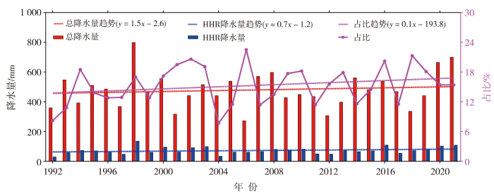
图3
1992—2021年三峡库区平均夏季总降水量、HHR降水量及其占比的年际变化及趋势
Fig.3
Inter-annual variation and its trend of average total precipitation, HHR precipitation and its proportion in the Three Gorges Reservoir area in summer from 1992 to 2021
探究三峡库区夏季HHR日变化特征,可增强对三峡库区天气气候的精细化认识。图4是1992—2021年三峡库区平均夏季总降水和HHR标准化降水量、频次和强度日变化,发现三峡库区夏季HHR标准化降水量、频次日变化相较于总降水波动多且振幅强,体现了HHR的突发性和高强度性;HHR标准化降水量和频次日变化均表现出峰值相当的双峰型,双峰分别出现在08:00和19:00,对应谷值分别出现在13:00和00:00,且13:00的谷值最低。可见,HHR标准化降水量与频次日变化特征非常一致,进一步表明三峡库区夏季HHR降水量主要源于降水频次的贡献。HHR和总降水的降水强度日变化振幅相当,且明显小于降水量和频次的日变化振幅,尤其是HHR。值得注意的是,三峡库区夏季HHR降水量和频次的下午峰值(出现在19:00)相比于总降水的下午峰值(出现在16:00)推迟了3 h,其原因有待进一步探索。
图4
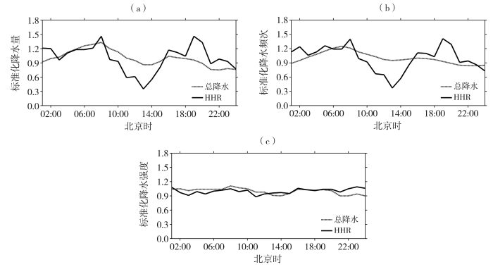
图4
1992—2021年三峡库区平均夏季总降水和HHR标准化降水量(a)、频次(b)、强度(c)日变化
Fig.4
The diurnal variation of average standardized precipitation (a), frequency (b) and intensity (c) of total rainfall and HHR in the Three Gorges Reservoir area in summer from 1992 to 2021
探究三峡库区夏季HHR日峰值时间位相特征,有助于理解该区域HHR的形成及演变规律。从图5可知,三峡库区夏季总降水、HHR的降水量与频次日峰值时间位相呈现相似的空间分布格局,区域一致性较强度日峰值时间位相强。夏季总降水的降水量、频次峰值大部站点出现在清晨,而HHR的降水量、频次峰值大部站点出现在下午,其次为清晨,降水量仅有1站(开县站)、频次仅有2站(开县、三峡站)峰值出现在夜间。HHR的降水量、频次日峰值时间位相与库区地形密切相关,峰值出现在下午的站点多位于库区东部相对高海拔山区,而峰值出现在清晨的站点多位于库区西部相对低海拔山区。这可能与地形差异造成的温度梯度日变化驱动的地形热力流有关(赵玉春等,2012;李强等,2017)。此外,与夏季总降水相比,库区西北部站点HHR的强度峰值多出现在夜间,表明库区西北部夜间HHR强度大,其原因有待进一步研究。
图5
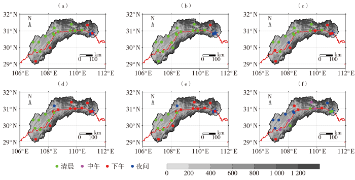
图5
1992—2021年三峡库区夏季总降水(a、b、c)和HHR(d、e、f)的降水量(a、d)、频次(b、e)、强度(c、f)日峰值时间位相(彩色圆点)空间分布
(灰色填充区为地形高度,单位:m)
Fig.5
The spatial distribution of diurnal peak time phase (color dots) of precipitation (a, d), frequency (b, e) and intensity (c, f) for total rainfall (a, b, c) and HHR (d, e, f) in the Three Gorges Reservoir area in summer from 1992 to 2021
(the grey filled areas for the terrain elevation, Unit: m)
3.2 三峡库区夏季HRE特征
3.2.1 HRE降水整体特征
由1992—2021年三峡库区夏季HRE降水量占比(与总降水量的百分比)空间分布[图6(a)]可见,夏季HRE局地性强,HRE降水量占比普遍超过22.0%,最大占比为31.7%,最小占比为18.6%,表明夏季HRE降水量对总降水量的贡献较大。夏季HRE降水量[图6(b)]与频次[图6(c)]的空间分布对应较好,高值区出现在库区西北部至中北部以及东南部,表明HRE降水量主要依赖其频次。夏季HRE平均降水量普遍超过50.0 mm,在库区中北部有一高值区[图6(d)],与HRE平均历时高值区[图6(f)]对应较好,同时在库区南部有一狭窄的高值带,与HRE平均强度高值区[图6(e)]对应较好,而库区东部HRE平均强度大、平均历时短,降水强度和历时的综合贡献使得库区东部HRE平均降水量与周边未产生较大差异。可见,三峡库区夏季HRE降水量是降水强度和历时综合作用的结果,降水量的多寡与降水强度和持续性有密切关系。
图6
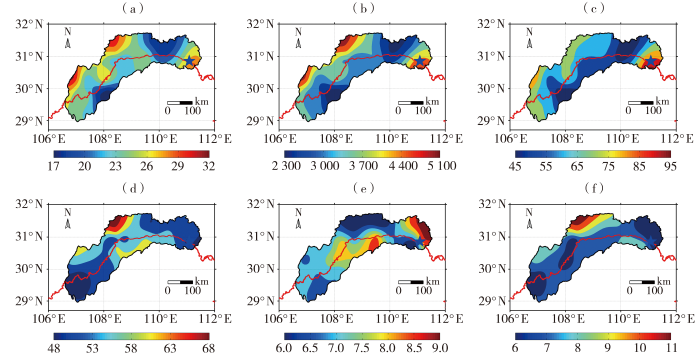
图6
1992—2021年三峡库区夏季HRE降水量占比(a,单位:%)和HRE降水量(b,单位:mm)、频次(c,单位:次)及平均降水量(d,单位:mm)、平均强度(e,单位:mm·h-1)、平均历时(f,单位:h)空间分布
Fig.6
The spatial distribution of proportion of HRE precipitation (a, Unit: %), and HRE precipitation (b, Unit: mm), frequency (c, Unit: times), average precipitation (d, Unit: mm), average intensity (e, Unit: mm·h-1) and average duration (f, Unit: h) in the Three Gorges Reservoir area in summer from 1992 to 2021
统计发现,1992—2021年三峡库区夏季HRE降水量最小为20.1 mm,最大为221.9 mm(历时39 h);HRE历时最小为1 h,最大为47 h;HRE强度最小为1.7 mm·h-1,最大为52.5 mm·h-1;HRE最大小时降水量最小为20.0 mm,最大为84.9 mm。从图7可知,三峡库区夏季HRE频次占比随降水量、历时和最大小时降水量增加而减小,随强度增加则呈先增后减的变化特征,夏季HRE的降水量多为20~<60 mm(占比约70.0%),历时多为1~6 h(占比约55.0%),降水强度多为5~<10 mm·h-1(占比约45.0%),最大小时降水量多为20.0~<30.0 mm(占比约65.0%)。可见,HRE集中发生在降水量、强度、历时和最大小时降水量较小(短)的区间,而极端HRE(最大值区间)的发生概率很小,这种极端HRE常常在短时间内产生大量降水,其突发性和高强度性更易造成洪涝及次生灾害,严重威胁长江流域防洪调度及三峡大坝安全,是天气预报、预警的重点和难点。
图7
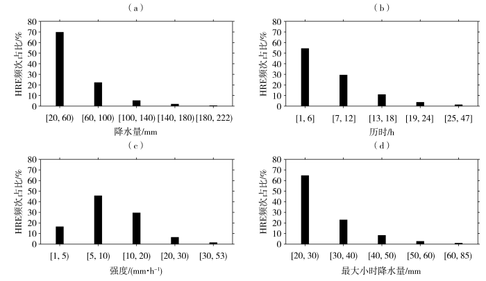
图7
1992—2021年三峡库区夏季不同降水量(a)、历时(b)、强度(c)和最大小时降水量(d)区间HRE频次占比
Fig.7
The proportion of HRE frequency under different intervals of precipitation (a), duration (b), intensity (c) and the maximum hourly precipitation (d) in the Three Gorges Reservoir area in summer from 1992 to 2021
图8是1992—2021年三峡库区夏季HRE开始、结束时间和最大小时降水量发生时间的频次占比,发现三者的日变化均呈双峰型。其中,HRE开始时间分别在21:00和24:00出现峰值,在12:00出现谷值,表明HRE多开始于下午和夜间而较少开始于中午,这与中国东部暖季HRE开始时间(Zhang and Zhai,2011)一致;HRE结束时间分别在20:00和23:00出现峰值,表明HRE多结束于下午和夜间;HRE最大小时降水量发生时间分别在08:00和19:00出现峰值,在13:00出现谷值,表明HRE的最大小时降水量多发生于清晨和下午,较少发生于中午。三峡库区夏季HRE日变化可能与太阳短波辐射加热和长江流域低空急流(Low Level Jet,LLJ)的日变化相关。研究表明,受太阳短波辐射加热影响,午后至前半夜的大气热力条件有利于触发强对流,进而易产生HRE(王国荣和王令,2013);长江与淮河之间的LLJ具有明显的日变化,通常在夜间最强(Fu et al.,2019),LLJ通过不断输送暖湿空气使得大气水汽含量和不稳定性增加(刘鸿波等,2014;Chen et al.,2021)。太阳辐射和LLJ作用使得三峡库区夏季HRE在下午和夜间活动频繁。
图8

图8
1992—2021年三峡库区夏季HRE开始、结束时间和最大小时降水量出现时间的频次占比
Fig.8
The proportion of HRE frequency at different starting time, ending time and occurring time with the maximum hourly precipitation in the Three Gorges Reservoir area in summer from 1992 to 2021
3.2.2 不同历时HRE降水特征
统计发现(表略),1992—2021年三峡库区夏季HRE共发生1 300次,其中短历时最多为708次(占54.5%),中历时次之,为383次(占29.5%),长历时最少为209次(占16.0%)。可见,三峡库区夏季HRE的持续时间存在明显差异,故对不同历时HRE的降水特征做进一步分析(图9)。由图9(a)看出,短历时、中历时HRE的降水量多为20~<60 mm,频次占比分别约90.0%、60.0%,频次占比随着降水量的增加逐渐减小,而长历时HRE的降水量多为60~<100 mm;对比发现,HRE最大降水量自短历时、中历时、长历时依次增加。由图9(b)可知,短历时、中历时HRE的频次占比随降水强度增大呈先增后减的特征,短历时的降水强度多为10~<20 mm·h-1,频次占比约50.0%,而中历时的降水强度多为5~<10 mm·h-1,频次占比超过60.0%;长历时HRE的频次占比则随降水强度增加而减小,绝大部分的降水强度低于10 mm·h-1;对比发现,高强度HRE的发生概率随历时增加而减小,HRE的最大降水强度自短历时、中历时、长历时依次减小。3种历时HRE的频次占比均随最大小时降水量增加而减小,且各区间频次占比相差不大,最大小时降水量介于20~<30区间的频次占比最大,均超过60.0%[图9(c)]。
图9
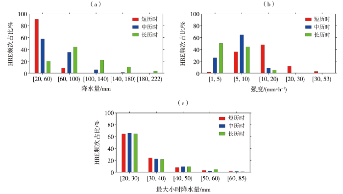
图9
1992—2021年三峡库区夏季不同降水量(a)、强度(b)和最大小时降水量(c)区间各历时HRE频次占比
Fig.9
The proportion of HRE frequency with different durations under different intervals of precipitation (a), intensity (b) and the maximum hourly precipitation (c) in the Three Gorges Reservoir area in summer from 1992 to 2021
综上可知,1992—2021年三峡库区夏季HRE发生频繁,以短历时为主,长历时的最少;HRE的最大降水量表现为短历时<中历时<长历时,而最大降水强度表现正相反;短历时、中历时HRE的降水量多为20~<60 mm,而长历时的多为60~<100 mm;随着降水历时的增加,高强度HRE的发生概率逐渐减小;3种历时HRE的发生概率随最大小时降水量的增加而减小,HRE的最大小时降水量多为20~<30 mm。
图10是1992—2021年三峡库区夏季3种历时HRE开始、结束时间和最大小时降水量出现时间的频次占比。可以看出,3种历时HRE的日变化特征明显不同,短历时HRE的开始时间和最大小时降水量出现时间均在下午出现峰值,而结束时间则在下午和夜间出现峰值;中历时、长历时HRE的开始时间均在夜间出现峰值,最大小时降水量均在清晨出现峰值,由于中历时HRE比长历时HRE持续时间短,导致结束时间前者在中午出现峰值,后者在下午出现峰值。综上可知,三峡库区夏季短历时HRE多开始于下午,由于历时短其最大小时降水量也多发生于下午;中历时、长历时HRE多开始于夜间,两者最大小时降水量多发生于清晨。
图10
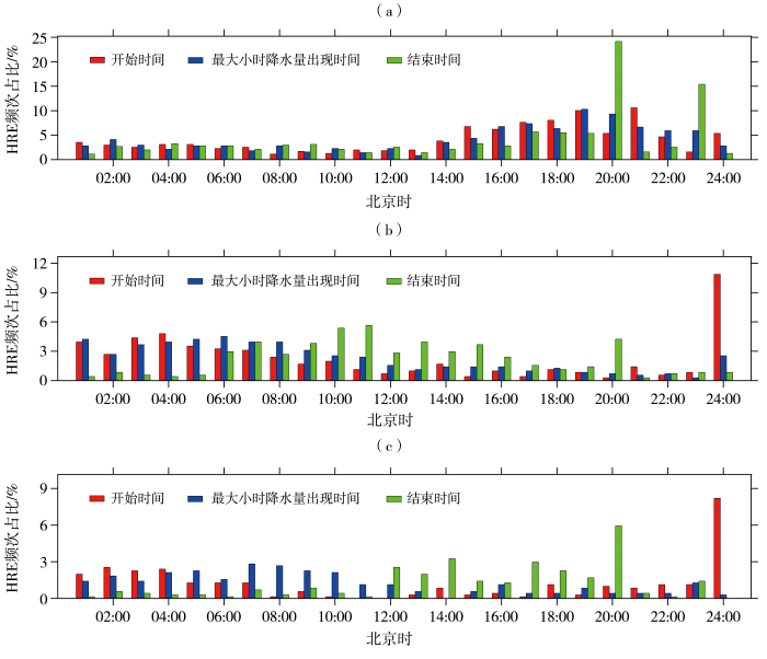
图10
1992—2021年三峡库区夏季短历时(a)、中历时(b)、长历时(c)HRE开始、结束时间和最大小时降水量出现时间的频次占比
Fig.10
The proportion of HRE frequency with short duration (a), medium duration (b), long duration (c) at different starting time, ending time and occurring time with the maximum hourly precipitation in the Three Gorges Reservoir area in summer from 1992 to 2021
4 结论与讨论
利用中国气象局国家气象信息中心提供的长序列站点逐小时降水观测资料,分析近30 a三峡库区夏季HHR时空分布特征,进一步探讨不同历时HRE的精细化特征,对深入认识该区域强降水天气及防灾减灾有重要意义。主要结论如下:
(1)三峡库区夏季HHR局地性强、强度大,库区东南部为高值中心,HHR、HRE降水量对总降水量贡献大,且主要源于降水频次的贡献,HRE降水量与降水强度和持续时间有关。
(2)近30 a来三峡库区夏季HHR降水量呈不显著增加趋势,HHR降水量和频次的日变化呈峰值相当的双峰型,峰值分别出现在清晨和下午,且日峰值时间位相与地形密切相关。
(3)三峡库区夏季HRE的降水量多为20~60 mm,历时多为1~6 h,强度多为5~10 mm·h-1,最大小时降水量多为20~30 mm,而极端HRE发生概率很小。
(4)三峡库区夏季HRE以短历时为主,长历时发生最少,最大降水量自短历时、中历时、长历时依次增多,而最大降水强度表现正相反;短历时、中历时HRE的降水量多为20~60 mm,长历时的多为60~100 mm,高强度HRE的发生概率随着历时增加而减小。
(5)三峡库区夏季HRE日变化也呈双峰型,多开始(结束)于下午和夜间,最大小时降水量多发生于清晨和下午。其中,短历时HRE多开始于下午,其最大小时降水量也多发生于下午,而中历时、长历时HRE多开始于夜间,两者的最大小时降水量多发生于清晨。
三峡库区复杂地形环境是影响夏季HHR空间分布及日变化特征的重要因素,HHR日变化还与太阳短波辐射加热和长江流域LLJ的日变化有关。研究表明,三峡库区降水变化在很大程度上受中国西南区域大尺度环流气候背景(陈鲜艳等,2013)、库区及上游流域自然状态和地表水文情势变化(黄亚,2019;郭广芬等,2021)影响,加之库区主城区不断扩张导致城市“雨岛”效应持续增强(邓梅,2020),进而影响其HHR。可见,三峡库区夏季HHR变化是多种因素叠加作用的结果(Luo et al.,2016;唐永兰等,2022;Tang et al.,2022)。在全球气候变暖背景下,天气系统愈加复杂,三峡库区及上游流域水文情势更加多变,随着库区城市化进程不断加快,该区域夏季HHR的演变规律还需综合多种因素做进一步探讨。
参考文献
陇东黄土高原旱区短时强降水的时空分布特征及地形影响研究
[J].
利用陇东黄土高原旱区2013—2020年302个区域自动气象观测站逐小时降水数据、数字高程模型数据和欧洲中期天气预报中心ERA5再分析资料等,分析短时强降水时空分布特征及其与地形、地理因子的关系,并结合2021年一次极端短时强降水事件,总结地形的影响机制。结果表明:(1)陇东黄土高原旱区短时强降水主要集中在夏季,7月日数占比(35.9%)最多、极端性最强,8月次数占比(46.9%)最多、强度最强;雨强主要分布在22.0~31.0 mm·h<sup>-1</sup>,日变化呈多峰型特征,17:00(北京时,下同)至次日00:00最为活跃,次数占比为56.8%,且强度和极端性最强。(2)短时强降水次数和小时雨量极值空间分布极不均匀,前者东南多、西北少,且随着雨强增大骤减,高发区主要集中在河谷喇叭口地形区,而掌地也是30.0 mm·h<sup>-1</sup>以上强降水高发区;后者中部小、东北与西南大,大值区主要分布在庆城东部—合水西部。(3)地理、地形因子对短时强降水次数影响显著,主要由地理位置贡献,而对极值无明显影响,地形强迫抬升并非是陇东黄土高原旱区短时强降水的主要影响机制。(4)山谷风环流及其诱发的地面中尺度辐合线是陇东黄土高原旱区河谷喇叭口地形区短时强降水形成的重要原因。
Spatial and temporal characteristics of abrupt heavy rainfall events over Southwest China during 1981-2017
[J].
Role of the nocturnal low-level jet in the formation of the morning precipitation peak over the Dabie Mountains
[J].
Seasonal variation of the diurnal cycle of rainfall in southern contiguous China
[J].Hourly station rain gauge data are employed to study the seasonal variation of the diurnal cycle of rainfall in southern contiguous China. The results show a robust seasonal variation of the rainfall diurnal cycle, which is dependent both on region and duration. Difference in the diurnal cycle of rainfall is found in the following two neighboring regions: southwestern China (region A) and southeastern contiguous China (region B). The diurnal cycle of annual mean precipitation in region A tends to reach the maximum in either midnight or early morning, while precipitation in region B has a late-afternoon peak. In contrast with the weak seasonal variation of the diurnal phases of precipitation in region A, the rainfall peak in region B shifts sharply from late afternoon in warm seasons to early morning in cold seasons. Rainfall events in south China are classified into short- (1–3 h) and long-duration (more than 6 h) events. Short-duration precipitation in both regions reaches the maximum in late afternoon in warm seasons and peaks in either midnight or early morning in cold seasons, but the late-afternoon peak in region B exists during February–October, while that in region A only exists during May–September. More distinct differences between regions A and B are found in the long-duration rainfall events. The long-duration events in region A show dominant midnight or early morning peaks in all seasons. But in region B, the late-afternoon peak exists during July–September. Possible reasons for the difference in the diurnal cycle of rainfall between the two regions are discussed. The different cloud radiative forcing over regions A and B might contribute to this difference.
Synoptic situations of extreme hourly precipitation over China
[J].In this study, synoptic situations associated with extreme hourly precipitation over China are investigated using rain gauge data, weather maps, and composite radar reflectivity data. Seasonal variations of hourly precipitation (&gt;0.1 mm h−1) suggest complicated regional features in the occurrence frequency and intensity of rainfall. The 99.9th percentile is thus used as the threshold to define the extreme hourly rainfall for each station. The extreme rainfall is the most intense over the south coastal areas and the North China Plain. About 77% of the extreme rainfall records occur in summer with a peak in July (30.4%) during 1981–2013.
Organization and environmental properties of extreme-rain-producing mesoscale convective systems
[J].This study examines the radar-indicated structures and other features of extreme rain events in the United States over a 3-yr period. A rainfall event is defined as “extreme” when the 24-h precipitation total at one or more stations surpasses the 50-yr recurrence interval amount for that location. This definition yields 116 such cases from 1999 to 2001 in the area east of the Rocky Mountains, excluding Florida. Two-kilometer national composite radar reflectivity data are then used to examine the structure and evolution of each extreme rain event. Sixty-five percent of the total number of events are associated with mesoscale convective systems (MCSs). While a wide variety of organizational structures (as indicated by radar reflectivity data) are seen among the MCS cases, two patterns of organization are observed most frequently. The first type has a line, often oriented east–west, with “training” convective elements. It also has a region of adjoining stratiform rain that is displaced to the north of the line. The second type has a back-building or quasi-stationary area of convection that produces a region of stratiform rain downstream. Surface observations and composite analysis of Rapid Update Cycle Version 2 (RUC-2) model data reveal that training line/adjoining stratiform (TL/AS) systems typically form in a very moist, unstable environment on the cool side of a preexisting slow-moving surface boundary. On the other hand, back-building/quasi-stationary (BB) MCSs are more dependent on mesoscale and storm-scale processes, particularly lifting provided by storm-generated cold pools, than on preexisting synoptic boundaries.
Characteristics of summer hourly precipitation under different urbanization background in central China
[J].The relationship between sub-daily precipitation and urbanization is widely concerned because short-term precipitation is sensitive to urbanization and difficult to predict. Using the data of summer hourly precipitation and urban development during 2007-2019 at four urban stations and an atmospheric background monitoring station in central China, this study investigates the characteristics of hourly precipitation and hourly extreme precipitation (HEP) under different urbanization background. It is found that high urbanization level may benefit precipitation intensity but not for accumulated precipitation amount and precipitation frequency, and it is also conducive to the occurrence of hourly precipitation within [20, 50) mm. Precipitation amount and frequency for hourly precipitation within [5, 50) mm have similar diurnal variation at fixed station, yet the diurnal variation of precipitation intensity is insignificant. The differences in temporal variation of precipitation are related to urbanization and terrain. Both high urbanization level and speed are conducive to summer HEP; especially summer HEP intensity may increase gradually under sustainable urbanization development. Although growth-type HEP occurs frequently with main contribution to total HEP precipitation amount in central China regardless of urbanization level, the frequency and contribution of continuous-type HEP tends to increase under high urbanization level and speed.© 2022. The Author(s).
Relation between rainfall duration and diurnal variation in the warm season precipitation over central eastern China
[J].

