干旱气象 ›› 2023, Vol. 41 ›› Issue (2): 279-289.DOI: 10.11755/j.issn.1006-7639(2023)-02-0279

• 论文 • 上一篇    下一篇

冷涡影响下两次不同类型强对流过程对比分析

褚颖佳1,2(), 郭飞燕1,3(), 高帆1,2, 胡鹏1,2, 郑丽娜1,2, 刘奕辰1,4, 鲁亓1,5   

  1. 1.山东省气象防灾减灾重点实验室,山东 济南 250031
    2.山东省济南市气象局,山东 济南 250102
    3.山东省青岛市气象局,山东 青岛 266003
    4.山东省章丘区气象局,山东 章丘 250200
    5.山东省济阳区气象局,山东 济阳 251400
  • 收稿日期:2022-02-10 修回日期:2022-05-16 出版日期:2023-04-30 发布日期:2023-05-09
  • 通讯作者: 郭飞燕(1986—),女,山西忻州人,博士,高级工程师,主要从事强对流天气机理分析和预报研究。E-mail: guofeiyan01@163.com
  • 作者简介:褚颖佳(1990—),女,河北唐山人,硕士,工程师,主要从事强对流天气研究。E-mail: ouccyj2009@163.com
  • 基金资助:
    山东省自然科学基金青年项目(ZR2021QD028);山东省自然科学基金项目(ZR2021MD010);山东省气象局预报员专项项目(SDYBY2017-05);山东省气象局预报员专项项目(SDYBY2019-05);山东省气象局预报员专项项目(SDYBY2020-04);山东省精准预报技术创新团队项目共同资助

Comparative analysis of two different types of severe convective processes under the influence of cold vortex

CHU Yingjia1,2(), GUO Feiyan1,3(), GAO Fan1,2, HU Peng1,2, ZHENG Lina1,2, LIU Yichen1,4, LU Qi1,5   

  1. 1. Laboratory for Meteorological Disaster Prevention and Mitigation of Shandong Province, Ji’nan 250031, China
    2. Ji’nan Meteorological Bureau of Shandong Province, Ji’nan 250102, China
    3. Qingdao Meteorological Bureau of Shandong Province, Qingdao 266003, Shandong, China
    4. Zhangqiu Meteorological Bureau of Shandong Province, Zhangqiu 250200, Shandong, China
    5. Jiyang Meteorological Bureau of Shandong Province, Jiyang 251400, Shandong, China
  • Received:2022-02-10 Revised:2022-05-16 Online:2023-04-30 Published:2023-05-09

摘要:

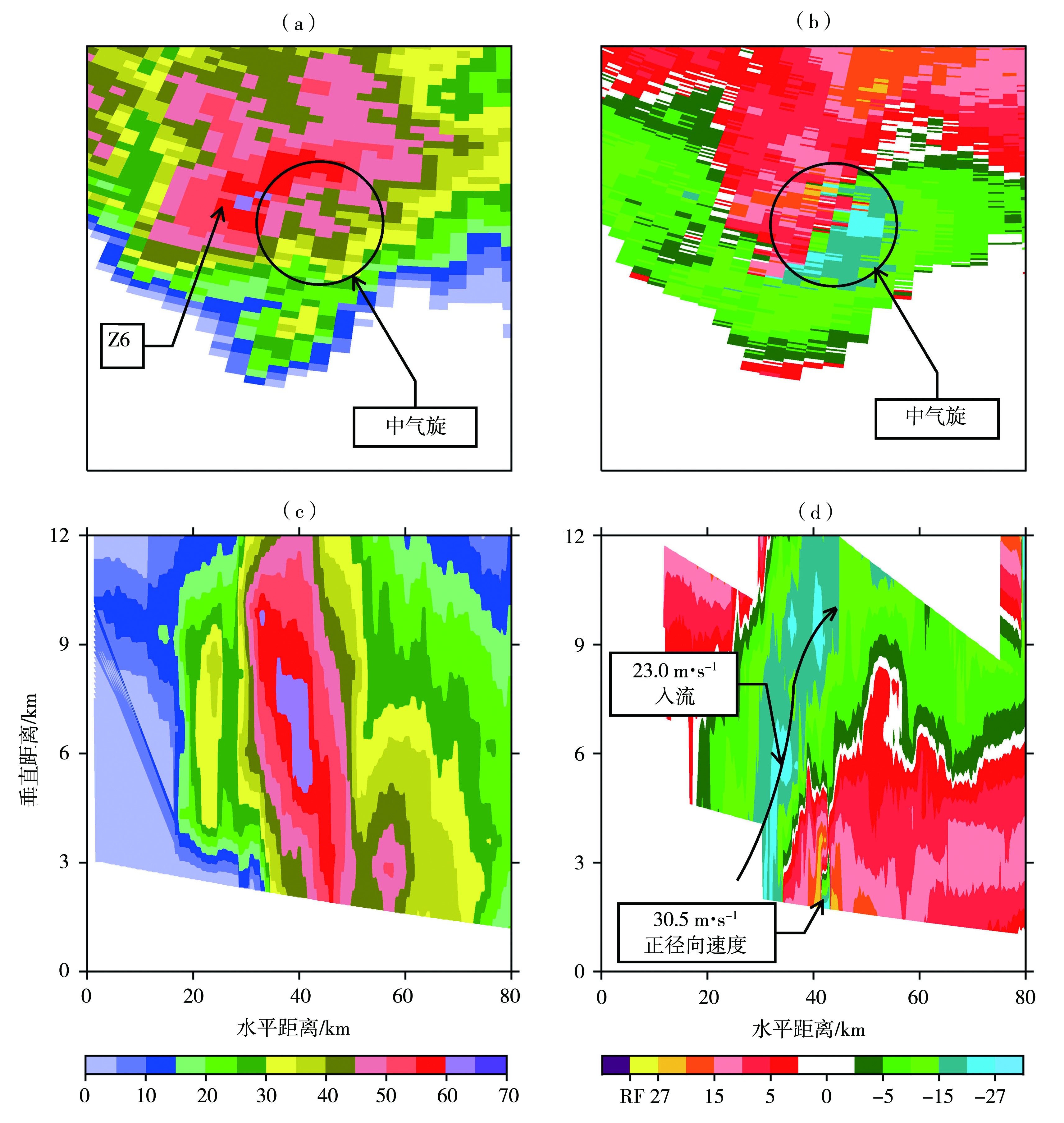
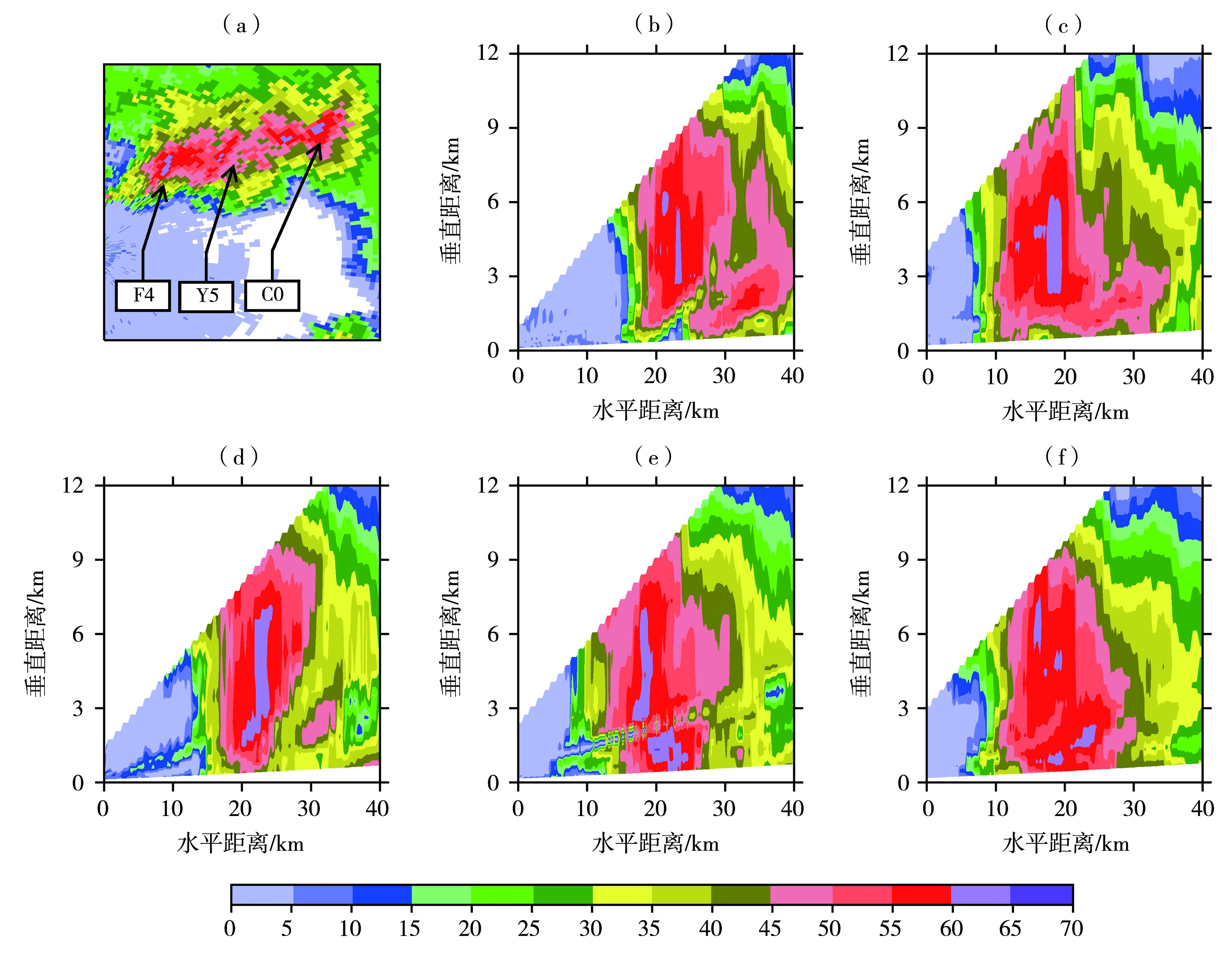
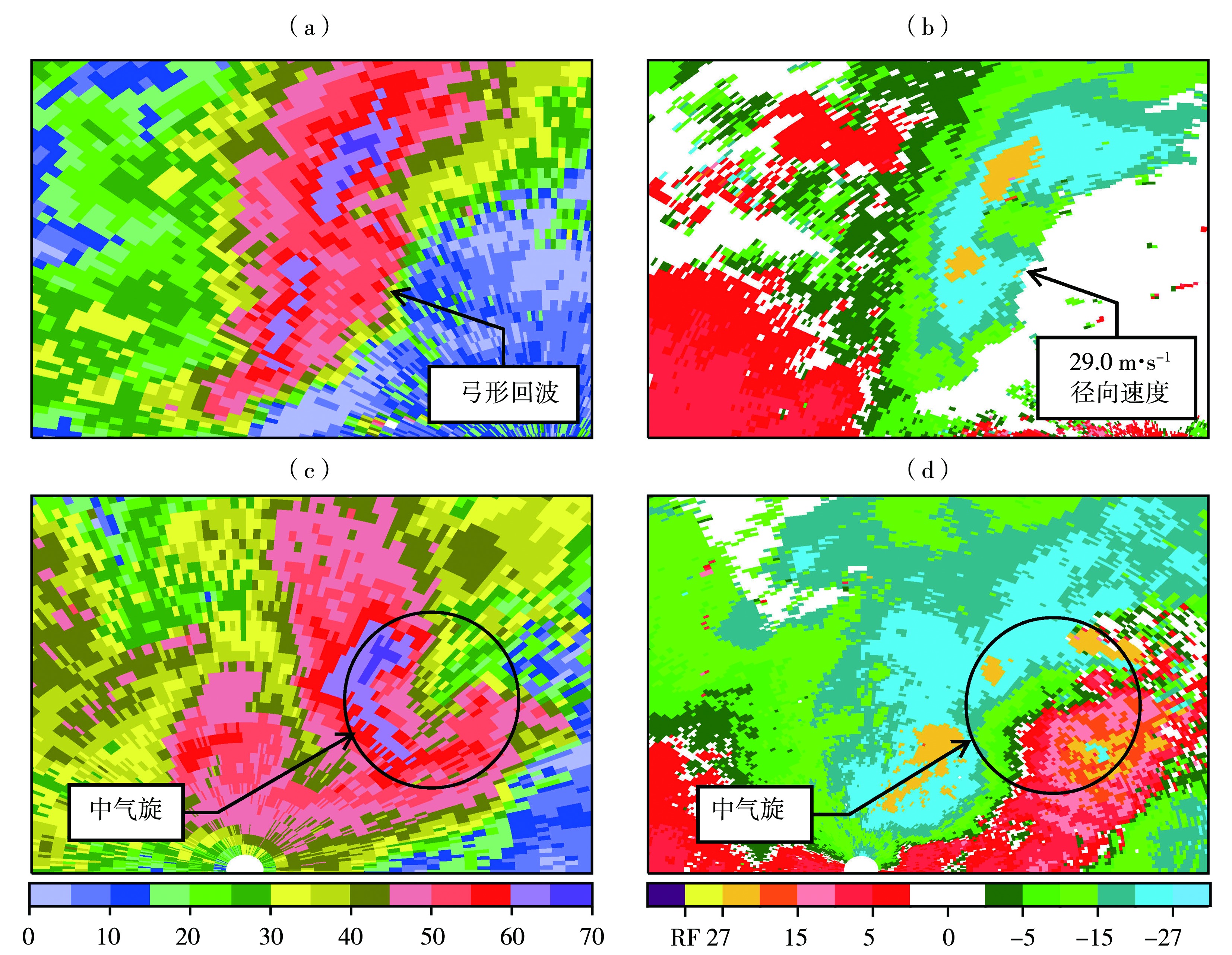
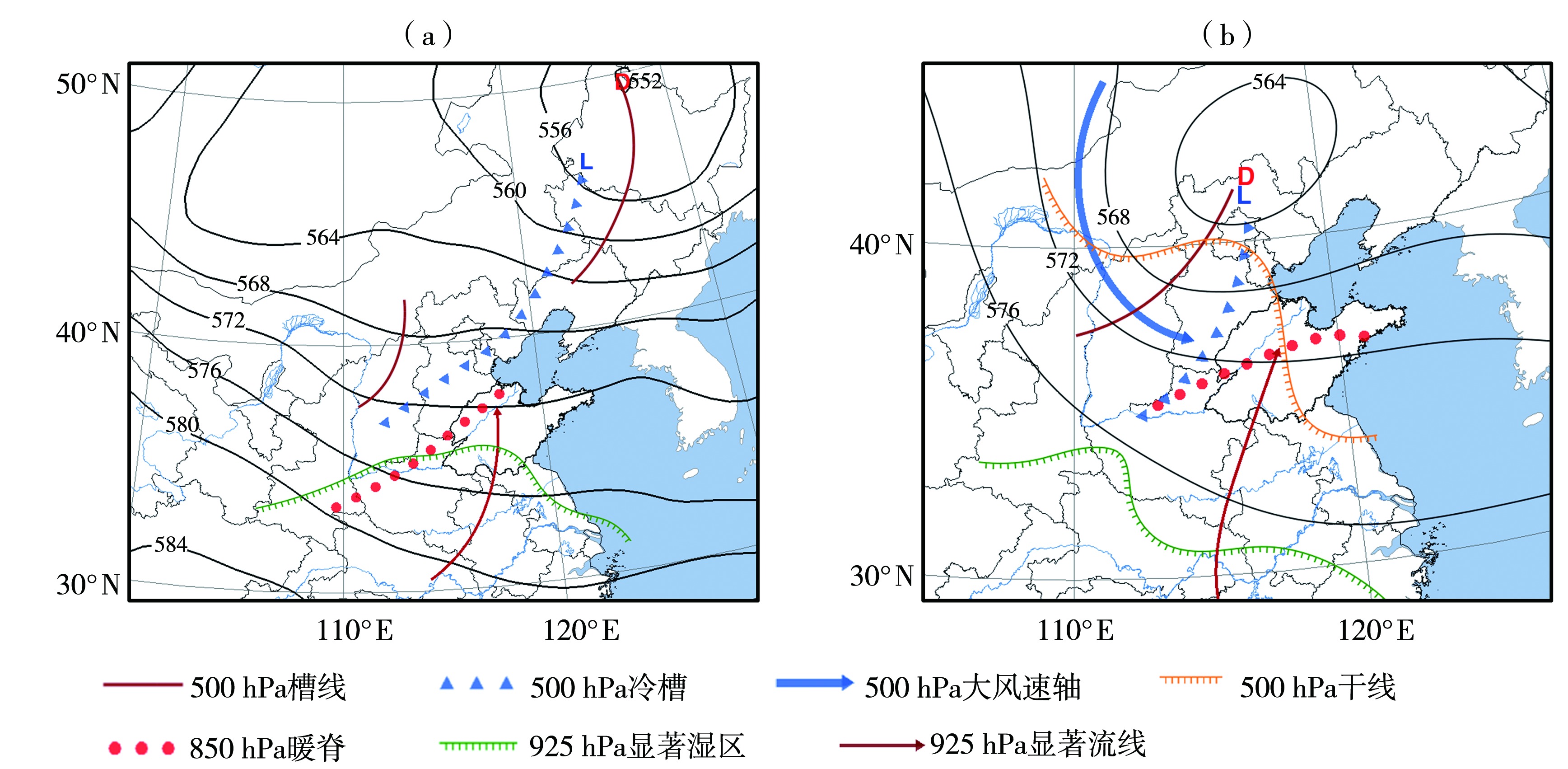
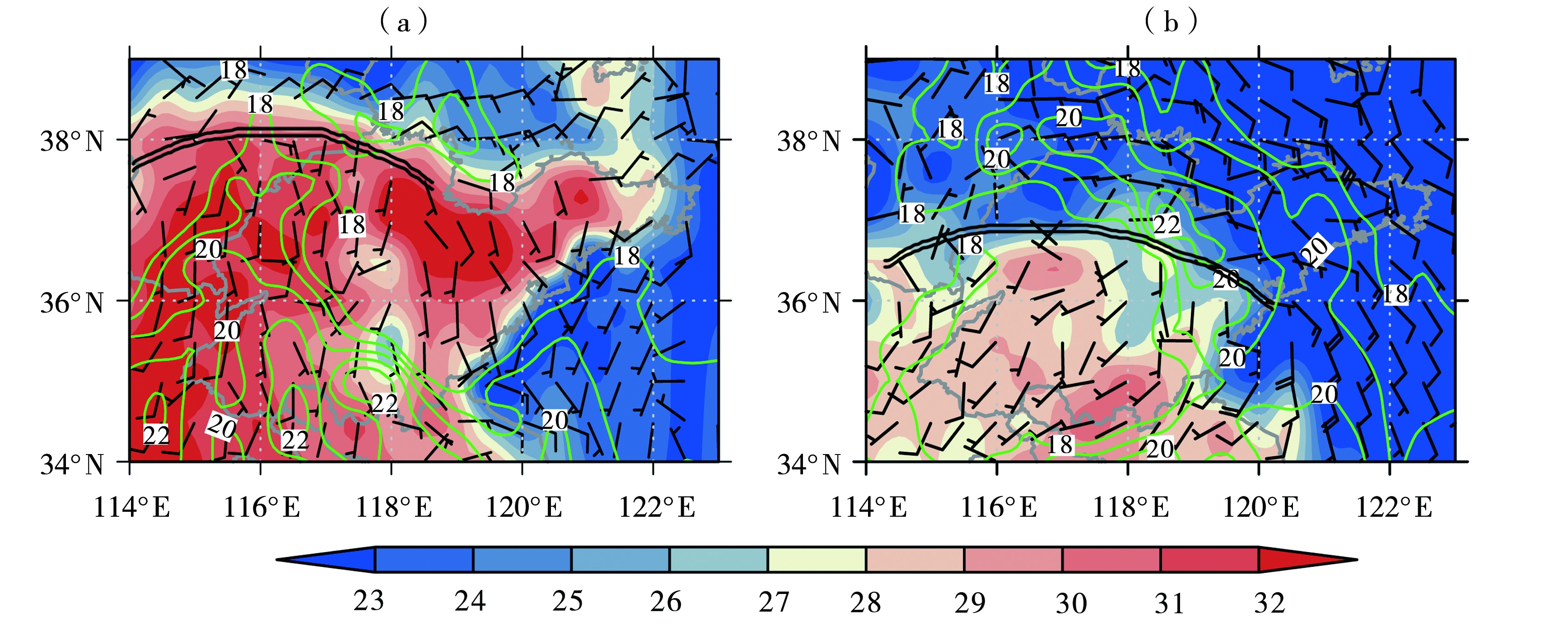
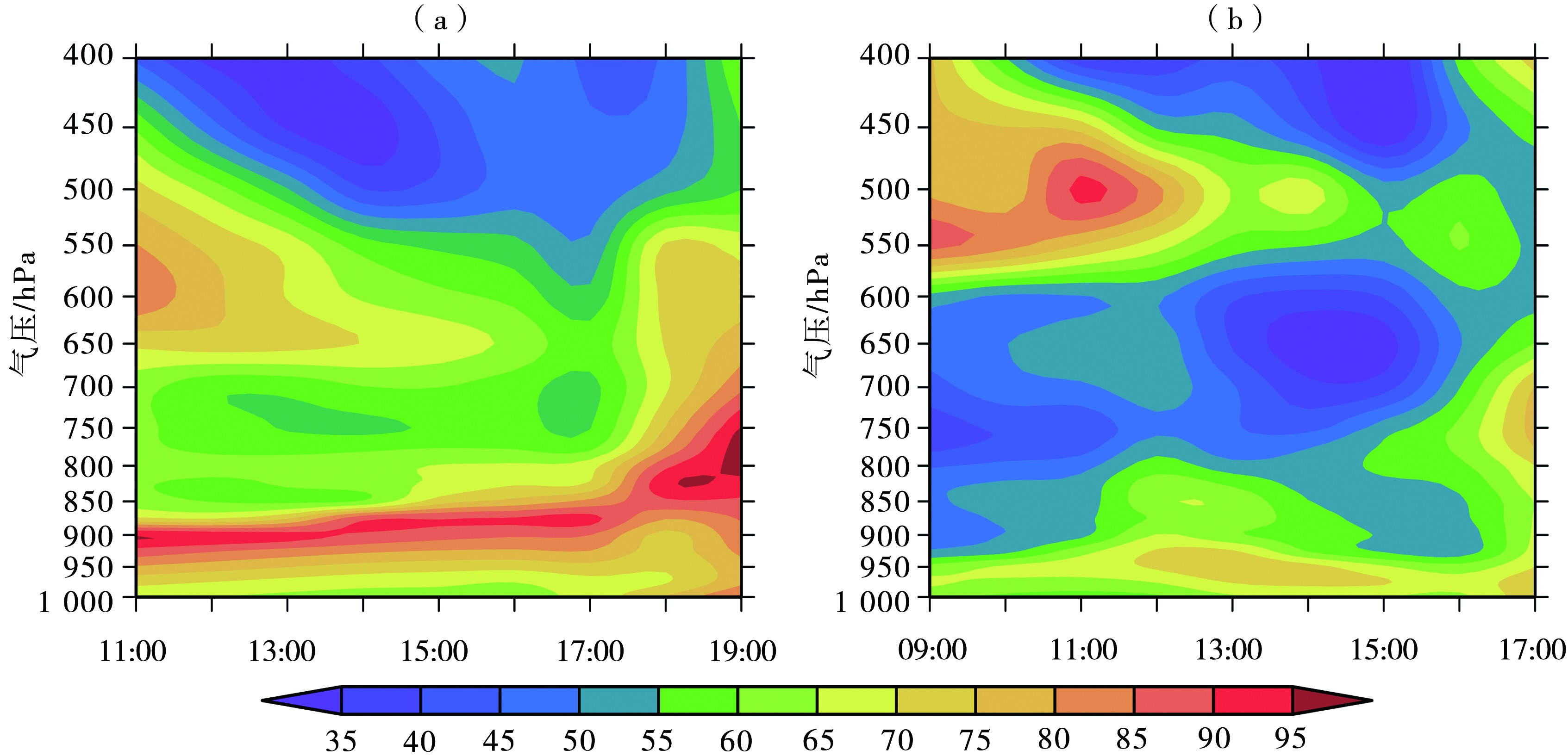
为深入认识冷涡影响下不同类型强对流天气发生条件的差异,利用高空、地面气象观测资料,多普勒天气雷达和风廓线雷达资料,以及欧洲中期天气预报中心(European Centre for Medium-Range Weather Forecasts,ECMWF)第五代大气再分析资料ERA5,对2016年6月13日和2018年6月13日山东两次同受冷涡影响但分别以短时强降水为主和风雹天气为主的不同类型强对流天气过程(分别简称“过程I”、“过程II”)进行了对比分析。结果表明:(1)以短时强降水为主的过程I,降水效率高,在其发展阶段回波质心高度低,成熟阶段形成强降水超级单体,最强降水出现在中气旋附近;以风雹天气为主的过程II,雷暴大风强度具有极端性,对流风暴发展深厚,60 dBZ以上强回波发展至-20 ℃层高度之上并持续,是产生大冰雹的重要原因。两次过程的强风均出现在弓形回波反射率因子核心前部和超级单体后侧下沉气流区。(2)过程I不稳定条件中等,西南气流配合湿区使低层增湿,950~850 hPa形成近饱和层并增厚,干层位于500 hPa以上,构成上干下湿层结,对流在地面辐合线和地面湿舌顶端叠加处触发;过程II热力和动力不稳定强,中空急流与800~600 hPa的显著干层为雷暴大风和冰雹的形成提供了有利条件,触发抬升系统是暖锋,比过程I更深厚。环境条件的差异决定了两次过程天气类型的差异。

关键词: 冷涡, 强对流, 环境条件, 垂直风切变

Abstract:

In order to deeply understand the difference of the occurrence conditions of different types of severe convective weather under the influence of cold vortex, different types of severe convective processes in Shandong Province on 13 June 2016 (process I) and 13 June 2018 (process II) which were dominated by short-term heavy rainfall and hail and extreme gale respectively were compared and analyzed based on the aerological and surface meteorological observation data, Doppler radar data, wind profiler radar data and the fifth generation atmospheric reanalysis ERA5 from European Centre for Medium-Range Weather Forecasts (ECMWF). The results are as follows: (1) In process I, which was dominated by short-term heavy rainfall, the precipitation efficiency was high. The echo centroid height was comparatively low in its developing stage, and a high precipitation supercell formed in its mature stage, the strongest precipitation occurred near the mesocyclone. In process II, which was dominated by hail and extreme gale, the intensity of thunderstorm gale was extreme, the convection storm developed deep, and the strong echo above 60 dBZ developed above the -20 ℃ layer and continued, playing an important role in the occurrence of large hail. The strong gales during the two processes appeared in the front of the bow echo reflectivity factor core and the rear flank downdraft (RFD) of the supercells. (2) In process I, the instability condition is moderate. The southwest airflow cooperated with the wet area to humidify the lower layers, and the near saturated layer was formed from 950 hPa to 850 hPa and thickened, the dry layer was above 500 hPa, forming the stratification of dry in the upper level and wet in the lower level, which was conducive to short-term heavy rainfall, and the convections were triggered at the superposition of the surface convergence line and the tip of the surface moisture tongue. In process II, the thermal and dynamic instabilities are strong, and the mid-tropospheric jet and the prominent dry layer from 800 hPa to 600 hPa provided favorable conditions for the formation of thunderstorm gales and the growth of hails. The triggering mechanism of process II was a warm front, which was deeper than the system of process I. Different environmental conditions of the two processes lead to the different types of convective weathers.

Key words: cold vortex, severe convection, environmental conditions, vertical wind shear

中图分类号: