近10 a北京地区10月两次区域性寒潮天气过程对比分析
|
|
马玉芳, 于波, 马秀梅, 郑玲, 马守存, 梁依玲, 王佳琳
|
Comparative analysis of two regional cold wave weather processes in October over Beijing in the past decade
|
|
MA Yufang, YU Bo, MA Xiumei, ZHENG Ling, MA Shoucun, LIANG Yiling, WANG Jialing
|
|
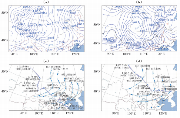
图7 2022年10月16日08:00(a)、2024年10月18日08:00(b)海平面气压场(等值线,单位:hPa)及2022年10月14—18日(c)、2024年10月17—20日(d)地面冷高压及冷锋演变
(字母G、D分别为高压和低压中心;蓝色线条上的三角形为冷锋,箭头指示冷高压移动路径)
|
Fig. 7 Sea-level pressure fields (contour lines, Unit: hPa) at 08:00 16 October 2022 (a) and 08:00 18 October 2024 (b), and the evolution of the surface cold high-pressure system and cold front during 14-18 October 2022 (c) and 17-20 October 2024 (d)
(The letter G and D denote the center of the high-pressure and low-pressure system, respectively; triangle along the blue lines represents cold fronts, the arrow indicates the propagation paths of the cold high)
|
|
|
|
|