), 傅朝1(), 刘维成1, 徐丽丽1, 刘娜1, 刘新雨2, 马绎皓1
), FU Zhao1(), LIU Weicheng1, XU Lili1, LIU Na1, LIU Xinyu2, MA Yihao1
), 傅朝1(), 刘维成1, 徐丽丽1, 刘娜1, 刘新雨2, 马绎皓1
), FU Zhao1(), LIU Weicheng1, XU Lili1, LIU Na1, LIU Xinyu2, MA Yihao1
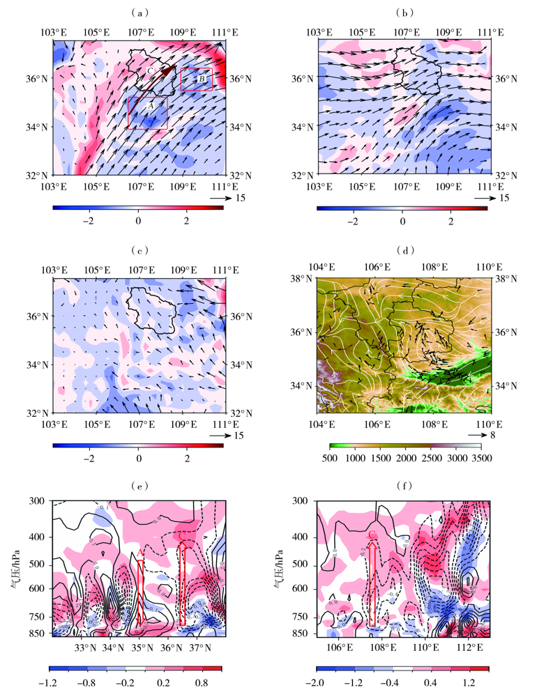
图11. 2022年7月15日06:00 700 hPa(a)和500 hPa(b)涡度(填色,单位:10-4 s-1)及风场(矢量,单位:m·s-1)、850 hPa散度(填色,单位:10-4 s-1)及风场(矢量,单位:m·s-1)(c)和15日04:00地面风场(矢量,单位:m·s-1)及地形高度(填色区,单位:m)(d)以及沿107.5°E(e)与沿36.5°N(f)的散度(填色,单位:10-4s-1)及垂直速度(等值线,单位:Pa·s-1)垂直剖面
(棕色箭头为低空急流,红色矩形区为低空急流入口区右侧和出口区右侧负涡度平流区,黑色线包围区域为庆阳市)
Fig.11. The 700 hPa (a) and 500 hPa (b) vorticity (the color shaded, Unit: 10-4 s-1) and wind field (vectors, Unit: m·s-1) and the divergence (the color shaded, Unit: 10-4 s-1) and wind field (vectors, Unit: m·s-1) at 850 hPa (c) at 06:00 BST July 15,2022, the surface wind field (vectors, Unit: m·s-1) and terrain height (the color shaded, Unit: m) at 04:00 BST July 15, 2022 (d), the zonal vertical section along 107.5°E (e) and the meridional vertical section along 36.5°N (f) of divergence(the color shaded, Unit: 10-4 s-1) and vertical velocity (isolines, Unit: Pa·s-1)
(The brown arrow line is low-level jet, and the red rectangular regions are negative vorticity advection areas on the right side of the entrance and the exit of low-level jet,and the area enclosed by black line is Qingyang)